Society of Wetland Scientists/ Association of State Wetland Managers Joint Regional Conference, Portland, OR, September 18, 2008
|
|
|
- Jocelyn Dawson
- 5 years ago
- Views:
Transcription

1 Reestablishing a Riverine Wetland Using Integrated Pest Management to Control Reed Canarygrass and Reference Wetlands Design Criteria to Restore Structure, Functions, and Habitat-Forming Processes Society of Wetland Scientists/ Association of State Wetland Managers Joint Regional Conference, Portland, OR, September 18, 2008 Mason Bowles, King County Department of Natural Resources and Parks
2 Today s Presentation Project Background Site Conditions Project Goals, Objectives Key Questions Controlling Reed Canarygrass Applying Design Criteria Implementing the Project Monitoring Results Conclusions Recommendations
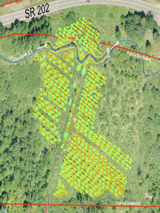
3 Project Background Seattle Public Utilities required to restore 1.2 acres of wetland as mitigation for 0.6 acres of wetland impacts from Tolt water pipeline King County elected to restore 4.3 acres of Patterson Creek Natural Area SPU hired King County DNRP to provide mitigation design, permit, construction, maintenance and monitoring services

4 Vicinity Map Project site is located 10 miles east of Bellevue in rural King County
5 Site Conditions 15.3 acre site Historically cleared, grubbed, graded and managed as hay pasture 14.3 acres of riverine flow-through wetland 1 acre upland Patterson Creek
6 Site Conditions Vegetation 6.7 acres of emergent wetland with reed canarygrass(phalaris arundinacea) 7.6 acres of forest, scrub-shrub wetland with black cottonwood (Populus balsamifera), Pacific willow (Salix lasiandra), Douglas spirea (Spirea douglasii) ~1 acre upland buffer with Oregon white oak (Quercus garyana), red alder (Alnus rubra), quaking aspen (Populus tremuloides)
7 Site Conditions Hydrology Patterson Creek is perennial Broad floodplain with high groundwater table supporting saturated and seasonally flooded wetlands. Located within the Snoqualmie Watershed Resource Inventory Area (WRIA 7).
8 Site Conditions Geomorphology Low-gradient (< 2%) with plane-bed meandering and braided channels Valley wall tributaries provide gravels and spawning habitat Soils Snohomish silt loam (hydric)

9 Site Conditions Habitat Patterson Creek contains cutthroat, rainbow/steelhead trout, Chinook and coho salmon. Adjacent undisturbed wetlands provide critical coho rearing habitat. Steelhead spawn in adjacent tributary streams. Regionally significant wildlife corridor.
10 Project Goals Provide 1.2 acres of compensatory mitigation for 0.6 acres of wetland impacts associated with Tolt water pipeline improvements Restore 4.3 acres of riverine flowthrough wetland structure, functions and habitat-forming processes

11 Key Questions: 1. How can reed canarygrass (RCG) be controlled? 2. How can design criteria be applied to restore wetland structure, functions and habitat-forming processes?

")
 to suppress")

 2.")


12 Controlling Reed Canarygrass Apply Integrated Pest Management (IPM) methods (Tu, 2002) to suppress RCG: 1. Mow RCG at peak of inflorescence (hard seed) 2. When RCG is 5-18 in tall spray with Rodeo 2% solution 3. Repeat treatment August 2002, 2003
13 Applying Design Criteria Reduce area of seasonal inundation favored by RCG by: 1. Creating mounds with seasonally saturated hydrology where trees can out-compete RCG 2. Creating pools with perennial hydrology and aquatic habitat which RCG does not favor

14 What are Design Criteria?
15 What are Design Criteria? Design criteria provide specific detail necessary to achieve project objectives Design criteria are numerical (e.g. elevations, stems per acre, feet per second, permeability) Design criteria provide acceptable or allowable tolerances for design components (i.e. minimum allowable limits of performance) Design criteria required for the Basis of Design report
16 Design Criteria may be: Analog/Reference (features in nature as a template for design) e.g. thin-stemmed emergent use by amphibians Empirical (mathematical relationships derived from observed relationships) e.g. relating bankfull discharge to channel width or depth Analytical (process-based approach to design) e.g. density-dependency relationships, RCG management strategies
 Special hydrologic studies of six wetlands, four heavily impacted by urbanization.")
17 Design Criteria from Reference Wetlands Derived from field studies of 19 wetlands in the Puget Sound Lowlands over 10 years (Puget Sound Wetlands Stormwater Management Research Program) Special hydrologic studies of six wetlands, four heavily impacted by urbanization. (King County)
 PSS (x) 10 5 0 0 10 20 30 40 50 60 70")
18 Average Plant Richness in Zone Plant Richness and Water Level Fluctuation PEM (x) PSS (x) Mean WLF (cm)
19 Design Criteria from Reference Wetlands Additional surveys of topography, snags and woody debris. 28 design criteria derived from reference wetlands (Azous, A.L, Bowles, M.B., Richter, K.O. 1998).
, 2.5-0.")
20 Design Criteria Example: Depth Definition: Water depth classes in the wetland during the intermediate growing season (May 16-September 15) based on WET (Adamus 1987) water depths Reference Standard: 3-4 WET water depths: < 2.5 cm (<1 inch), cm (1-6 inches), cm (6-20 inches), cm (20-60 inches), and > 152 cm (>60 inches Design Criteria: Create variable water depths and modify soil hydrology by constructing 450 mounds and pools. Mounds shall be constructed from native soils, minimum of 4x4 ft, maximum of 6 x 6 ft with pools 1.5 to 2.5 ft deep

21 Construction of Mounds and Pools 4 x 4 ft ft tall/ deep Mound formed using native soils from excavated pool material
22 Design Criteria Example: Woody Debris Definition: The amount, size, and distribution of woody debris in the wetland. Reference Standard Quantity 40 to 214 m3. Small 11 to 40% Medium 26 to 31% Large 30 to 60% 7:1 to 17:1 coniferous to deciduous wood 49 to 193 snags per hectare

23 Design Criteria Example: Woody Debris Design Criteria Small Medium Large Totals Diameter 0-15cm/0-6 inches 16cm-50cm/6-20 inches >50cm/>20 inches Length 0-3m / ft 3.1-6m / 3-12 ft >6m / >12 ft TOTALS

24 Implementation Prepare design plans Obtain Federal, State, Local permits NWP 27 Section 401 Hydraulic Project Approval NPDES Grading


25 Implementation: Mow and spray reed canarygrass for 2 yrs

26 Implementation: 2003 Survey and stake location of rows where mounds and pools will be constructed

27 Implementation: 2003 Install construction matting for access

28 Implementation: 2003 Construct 426 mounds and pools

29 Implementation: 2003 Place 846 pieces of small, medium and large woody debris

30 Implementation: 2003 Plant >1,000 live stakes of Pacific willow and black cottonwood

31 Implementation: yr flood event 10 days after construction

32 Implementation: 2004 Sheet mulch mounds with 4x8 sheets of cardboard and 4-6 of wood chips
 Mow between")
33 Implementation: 2004 Plant 2,560 trees and shrubs (~ 3-4ft OC) Mow between mounds
34 Planted species plot survival Common Name # Alive 2007 Total Number Planted % Survival Trees black cottonwood stakes and potted % Sitka spruce % red alder % Western red cedar % Shrubs Pacific willow % Sitka willow % Totals: %

35 Post-Construction

36 Monitoring Results: 2007
37 Monitoring Results: 2007 Goal, Objectives Project Goal Performance Standard Provide 5.5 acres of compensatory mitigation for 0.6 acre of wetlands impacts Monitoring Results 6.14 acres of wetland restored Objective 1: Establish 5.5 acres of native woody plant species < 6 meters (~20 feet) tall. Years 1, 3: Survivorship of planted species will be 70% of each species. DDES requires 80% survival of each species after 5 years, with monitoring in Years 3 and 5. Year 3 survival >70%. Actual = 86% Year 3 aerial cover of woody trees and shrubs was 38% in 2007
38 Monitoring Results: 2007 Goal, Objectives Performance Standard Monitoring Results Objective 2: Install 2,560 woody plants, including three native shrub and four tree species to increase overall plant richness. Objective 3: Limit invasive plant species to < 20 percent cover for each monitoring period. Woody plant community richness by year 10 will equal > 7 species. Non-native and other invasive plant species Himalayan blackberry, Japanese knotweed, Evergreen blackberry, reed canarygrass, Scotch broom, English ivy, morning glory, etc. may only comprise up to 20 percent aerial cover for each monitoring period. Woody plants = 7 species in 2007 Invasive cover in 2007 included reed canary grass (88%) and yellow-flag iris (3%) Invasive cover, except for reed canary grass, remain under a 5% total cover
39 Monitoring Results: 2007 Goal, Objectives Performance Standard Monitoring Results Objective 4: Maintain existing wetland hydrology for each monitoring period. Objective 5: Establish large and small organic debris by monitoring year 5. Soils will be saturated to the surface, or standing water will be present in a monitoring well at 12 inches below the surface or less, for a consecutive number of days greater than or equal to 12.5% of the growing season, for monitoring years one through ten. The following amounts of wood shall be present by monitoring year 5: 546 pieces of small organic debris; 198 pieces of medium organic debris; and 76 pieces of large organic debris. Standing water was observed at 66% of plots in August 2007, indicating the presence of wetland hydrology in the growing season. A total of 846 pieces of woody debris are present including 447 pieces of small wood, 254 pieces of medium wood, and 145 pieces of large wood.
40 Monitoring Results: 2007 SAM Functions* Pre- Construction (2000) Post- Construction (2007) Flood/Stormwater Control 6 9 Baseflow Groundwater Support 8 11 Erosion/Shoreline Protection 6 9 Water Quality Improvement Natural Biological Support Overall Habitat Functions 6 8 Specific Habitat Functions 5 15 Cultural/Socioeconomic *Cooke, Sarah S., 2000
41 Monitoring Results: 2007 % of Total Score Flood/Stormwater Control Baseflow Groundwater Support Erosion/Shoreline Protection Water Quality Improvement Natural Biological Support Overall Habitat Functions Specific Habitat Functions Cultural/Socioeconomic 0 Pre-Construction (2003) Post-Construction (2008)
42 Monitoring Results: % decrease in RCG dominance (from 100% - 88%! ) Increase in tree and shrub cover (38%) Regulatory Performance Standards satisfied within 3 years, except for RCG cover Wetland functions increased within 3 years Increase in plant species richness (n = 4 in 2003, n > 25 in 2007) Increase in fish use with three spine stickleback and coho juveniles found utilizing pools Increase in amphibian breeding and rearing Increase in bird use by marsh wren, sandpiper, common snipe, killdeer

43 Pre-construction Photograph Summer 2002

44 Pre-construction Photograph Summer 2003

45 Construction Photograph October 10, 2003

46 Construction Photograph October 21, 2003

47 Post-construction Photograph Summer 2004

48 Post-construction Photograph Summer 2005

49 Post-construction Photograph Summer 2007


50 Post-construction Photograph Summer 2008
51 Conclusions: IPM Treatment Pre-construction treatment of RCG was biologically effective >80% die-off of RCG in treatment area Herbicide treatment provided only short term (<2yr) control of reed canary grass. >3 years RCG was dominant emergent (88% cover)
52 Conclusions: Design Criteria from Reference Wetlands Design criteria from reference wetlands provided organizational framework for making design decisions Design criteria from reference wetlands provided detailed information on structural characteristics; e.g density and distribution formulas for specifying wood debris Other design criteria (e.g. analytical) required to overcome landscape-level stressors (RCG) using IPM suppression methods
53 Project Costs Planning, Design, Permits $72,079 Construction $123,395 Maintenance & Monitoring $37,509 TOTAL PROJECT COST $ 232,984 Unit Cost $38,830 p/acre
 Remove weed fabric from mounds Enhance buffer with additional")
54 Next Steps Thin and release conifers: Sitka spruce (Picea sitchensis), Western red cedar (Thuja plicata) Remove weed fabric from mounds Enhance buffer with additional plantings
55 Acknowledgements Seattle Public Utilities King Conservation District Fauna Nopp, Landscape Architect Laura Hartema, Ecologist Laird O Rollins, Ecologist
56 References Azous, A.L and Richard R. Horner Wetland and urbanization: implications for the future. Final report of the Puget Sound wetlands stormwater management research program. Washington State Department of Ecology, Olympia, WA Azous, A.L, Bowles, M.B., Richter, K.O Reference standards and project performance standards for the establishment of depressional flowthrough wetlands in the Puget Lowlands of Western Washington. King County Department of Development and Environmental Services, Renton, WA. Sarah S. Cooke, Wetland and Buffer Functions Semi-Quantitative Assessment Methodology (SAM), May 2000, Cooke Scientific, Seattle Tu, Mandy and Dan Salzer Integrated management strategies for the control of reed canarygrass in Western Oregon: 2001 progress report and proposal for the 2002 field season. The Nature Conservancy of Portland, OR.
57 Contact Information Mason Bowles, P.W.S. Senior Ecologist, Capital Projects Section Water and Land Resources Division King County Department of Natural Resources and Parks 201 S. Jackson, Suite 600 Seattle, WA, dnr.metrokc.gov/wlr/