Tools for archaeologists
|
|
|
- Delphia Cooper
- 5 years ago
- Views:
Transcription


1 Tools for archaeologists Estimating fuel loads Calculating first order fire effects Post-fire erosion modeling Rachel Loehman, USGS Ana Steffen, NPS


2 Surface fuel sampling: The Photoload sampling technique


 Fire")


3 Fire: From fuels to fire effects Fire environment Terrain Weather Fuels Size, shape Moisture content Quantity Spatial arrangement (vertical and horizonal) Fire behavior Depth of burn Residence time Temperature Combustion byproducts Oxidation, reduction Fire effects
, 13% pinon-juniper woodlands and 1% shrub or grass cover. The Fuel Models for this project will be FM 9, FM 10 and FM 6.")
4 Fire environment: Fuels Vegetation/Fuels Description: On-site fuels data: Ponderosa Pine is the dominate forest cover, covering 73% of the project area. About 13% is mixed conifer forest (on cool moist slopes), 13% pinon-juniper woodlands and 1% shrub or grass cover. The Fuel Models for this project will be FM 9, FM 10 and FM 6. Fuel Model 9 73% of project area Total Fuel Load, < 3-inch dead and 3.5 live, tons/acre Dead Fuel Load, ¼- inch, tons/acre 2.9 Live Fuel Load, Foliage, tons/acre 0 Fuel bed depth, feet 0.2 Fuel Model 10 13% of project area Total Fuel Load, < 3-inch dead and 12.0 live, tons/acre Dead Fuel Load, ¼- inch, tons/acre 3.0 Live Fuel Load, Foliage, tons/acre 2.0 Fuel bed depth, feet 1.0


5 Photoload: Visual fuels estimation method


6 Photoload: 1, 10, and 100-hour fuels


7 Photoload: Shrub and herbaceous fuels


8 Pre-fire loadings Consider several plots per site to capture range of conditions Immediate post-fire loadings 1 year postfire loadings

9 FOFEM: First Order Fire Effects Model First order fire effects immediate, direct or indirect consequences of a fire. FOFEM tool calculates consequences for prescribed fire or wildfire using four separate metrics: tree mortality, fuel consumption, emissions or smoke production, and soil heating.


10 Inputs Geographical region Forest type Season of burn and general burning conditions Fuel type, fuel loading by size class, fuel moisture Duff depth and moisture Soil texture and soil moisture percentage Outputs Preburn fuel loading, fuel consumed, postburn loading Tree mortality by species and size, pre- and postfire canopy cover Mineral soil exposure Emissions from flaming and smoldering combustion Soil layer maximum temperatures and duration of heating


11


12 Planning: Model calculates expected fire effects from field conditions (your data) Prediction: Model generates a range of field conditions that may lead to a specified set of desired (or unwanted) effects Quantifies important fire effects for resource preservation tree mortality, flame lengths, fuel consumption, surface and subsurface heating Aids in design of post-fire surveys and rehabilitation projects identify where greatest impacts might be?? OTHER IDEAS?? Why use FOFEM for archaeology?


 10")
13 Post-fire Erosion Modeling: 2 nd Order Effects Burn Severity High Moderate Low (unchanged) 10 miles / 16 km


14

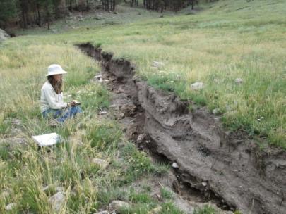
15 Pic of fans on the ground


16 1 km 1 mile


17
18 Tillery, A.C., and Haas, J.R., 2016, Potential postwildfire debris-flow hazards A prewildfire evaluation for the Jemez Mountains, northcentral New Mexico: U.S. Geological Survey Scientific-Investigations Report


19 Tillery, A.C., and Haas, J.R., 2016, Potential postwildfire debris-flow hazards A prewildfire evaluation for the Jemez Mountains, northcentral New Mexico: U.S. Geological Survey Scientific-Investigations Report


20 Inputs: Topography Watershed areas Watershed Boundary Datasets: hydrologic units Soils Soils data for US: Burn severity Range of precipitation conditions Megan Friggens, USFS Rocky Mountain Research Station ArcBurn Project
21 Identify sites at risk for erosion damage Understand past/prehistoric debris events Megan Friggens, USFS Rocky Mountain Research Station ArcBurn Project....


22 Identify sites at risk for erosion damage Understand past/prehistoric debris events Megan Friggens, USFS Rocky Mountain Research Station ArcBurn Project....