Conifer Encroachment in a Montane Meadow, Western Cascade Range, OR.
|
|
|
- Ira Cox
- 5 years ago
- Views:
Transcription

1 Conifer Encroachment in a Montane Meadow, Western Cascade Range, OR. Ryan D. Haugo Charles B. Halpern College of Forest Resources University of Washington, Seattle
2 Conifer Encroachment Widespread phenomenon Three widely proposed causes Fire suppression Climate change Sheep grazing Interactions among causes Woodward et al. 1995, Miller and Halpern 1998

3 Bunchgrass Meadow, Oregon Site description Dry, montane meadow, 1300m elevation Grand fir and lodgepole pine Soils formed under meadows Current studies Process and consequences of encroachment Experimental restoration Bunchgrass Meadow
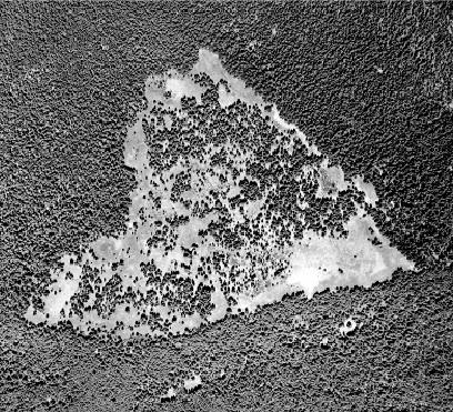
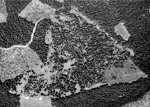
4 Bunchgrass Meadow, Oregon

5 4, 1 ha Intensive Sampling Plots
6 Objectives Examine temporal patterns and potential causes of conifer encroachment Climate variation Grazing Changing fire regime / Native American use Describe spatial patterns of conifer encroachment Spatial distributions through time Role of species interactions
7 Timing of Establishment Timing of Establishment , Combined age structure Grand fir Lodgepole pine Other species n = 5, 486 trees Number of stems per hectare Establishment period
8 Climate Precipitation, PDSI, Temperature, Snow Pack Climate reconstructions from Miller 1995 Spearman Rank Correlation Positive correlation with snow pack (p<0.01) 92.5% of total precipitation September through May Substantial conifer establishment
9 Burke (1979) Sheep Grazing Lookout Mountain / Mt. Washington Allotment sheep/year Historical Records, Willamette NF Too many Bunchgrasses Substantial establishment prior to 1938
10 Fire History Mixed severity landscape Morrison and Swanson (1990) and Stewart (1986) Lack of physical evidence Potential influence of Native Americans Unique resources Native American use of fire widely debated
11 Native Americans Molalla Indians Possible historic use Disease epidemics 1830s 1855 executive order ceded Molalla lands, relocated to Grand Ronde Valley Warm Springs Indians late 1800s to 1920s Potential grazing and burning
12 Combined age structure Establishment period Euro-American sheep grazing Grand fir Lodgepole pine Other species Potential Warm Springs grazing and burning Shift to cooler, wetter climate Molallas moved to Grand Ronde Molalla Disease Epidemics Number of stems per hectare

13 Spatial Patterns of Establishment Spatially and temporally complex Species specific
14 Plot Y (m) Grand fir Lodgepole pine Other species Dead grand fir (15-30 cm dbh) Dead lodgepole pine (15-30 cm dbh) X (m)
15 Plot Y (m) Grand fir Lodgepole pine Other species Dead grand fir (15-30 cm dbh) Dead lodgepole pine (15-30 cm dbh) X (m)
16 Plot Y (m) Grand fir Lodgepole pine Other species Dead grand fir (15-30 cm dbh) Dead lodgepole pine (15-30 cm dbh) X (m)
17 Plot Y (m) Grand fir Lodgepole pine Other species Dead grand fir (15-30 cm dbh) Dead lodgepole pine (15-30 cm dbh) X (m)
18 Plot Y (m) Grand fir Lodgepole pine Other species Dead grand fir (15-30 cm dbh) Dead lodgepole pine (15-30 cm dbh) X (m)
19 Plot Y (m) Grand fir Lodgepole pine Other species X (m)


20 Lodgepole Establishment


21 Lodgepole Grand Fir Facilitation


22 Lodgepole Grand Fir Facilitation
23 Temporal patterns and potential causes Two periods of conifer establishment Climate, Grazing Secondary influences Native American burning? Encroachment coincides with changes in Native American activity
24 Spatial patterns Spatially and temporally complex Initial establishment of lodgepole Facilitation of grand fir tree islands Ongoing research Spatially explicit analysis Vegetation responses to encroachment

25 Joint Fire Sciences Program, HJ Andrews LTER Fred Swanson and John Cissel Jim Mayo, Sam Swetland, Cheryl Friesen, Mei Lin Lantz, Monty Wilson McKenzie River Ranger District Joe Antos, Don Mckenzie Committee Members Nicki Lang, Jim Lutz, Kyle Smith, Janine Rice, Halpern lab group and BG field crews