Dye Creek Orchards Los Molinos, California
|
|
|
- Lindsey Bryan
- 5 years ago
- Views:
Transcription
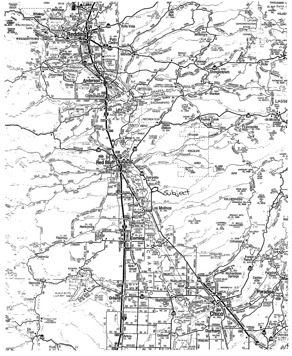
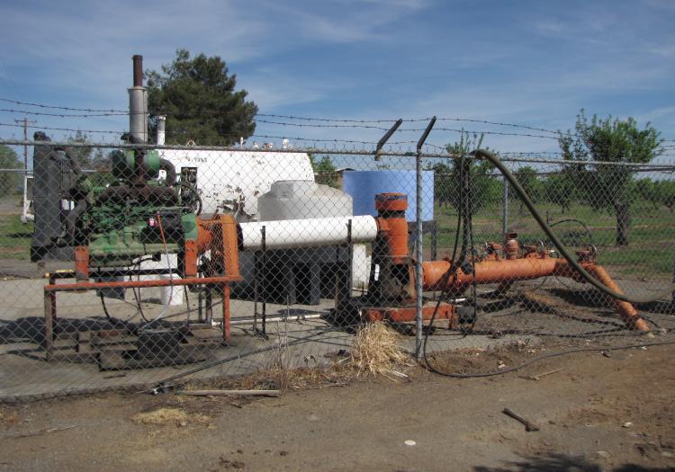
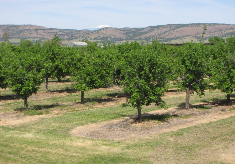
1 AG-LAND INVESTMENT BROKERS 275Sale Lane / P. O. Box 896 Red Bluff, CA office / fax Dye Creek Orchards Los Molinos, California Listing Price: $1,950,000. Seller financing available upon approved credit and terms. Seller will consider selling the property in (3) separate blocks or by individual parcel. Property: Approximately 159 total acres consisting of 141 acres planted to producing English walnuts and French prunes. The balance of the acreage is comprised of roads, ditches, farmstead area and lands within Dye Creek. Location: The property is located in central Tehama County, east of the Sacramento River. It is about 9 miles (S) of Red Bluff and 3 miles (N) of Los Molinos at Highway 99E, Los Molinos, California, Except for a band along the banks of Dye Creek, the property is not in the 100 year flood plain. Zoning: 3 of 11 parcels are zoned EA, 10 acre minimum. EA = Exclusive Agriculture (Cropland). The remaining 8 parcels are zoned EA-AP, 40 acre minimum. (EA = Exclusive Agriculture (Cropland), AP = Agricultural Preserve (Williamson Act Contract). The 5.13 acre parcel on the corner of Sixty Second Avenue and Highway 99E with the shops and home could be used for an AG related business with a use permit. Soils: The soil is primarily Vina Clay Loam, a Class I soil. The Class III soils are Berrendos Clay, Anita Clay, Anita Keefers Complex, and Molinos Complex and are found in the NE corner of the property. The Class IV soil is Millrace Gravelly Fine Sandy Loam and is found in the SE corner of the property. Topography: Flat to level to grade. Dye Creek, a year round stream borders the property on the south side. Dye Creek flows east to west and discharges into the Sacramento River west of the property. The property offers exceptional views of Lassen Peak and eastern mountain ranges. Water: Irrigation water is provided by (2) AG wells powered using diesel engines. Water from these wells is delivered to the orchards through inter-connected buried PVC mainline. Domestic water is provided by (5) wells using electric motors. The information contained herein is from sources deemed reliable, however, accuracy is not guaranteed. AG-LAND Investment Brokers assumes no liability as to errors, omissions or future operating and investment results. Buyer assumes responsibility to perform their own investigation and due diligence. This offering is subject to prior sale, price change or withdrawal from market without notice.
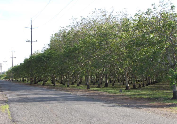
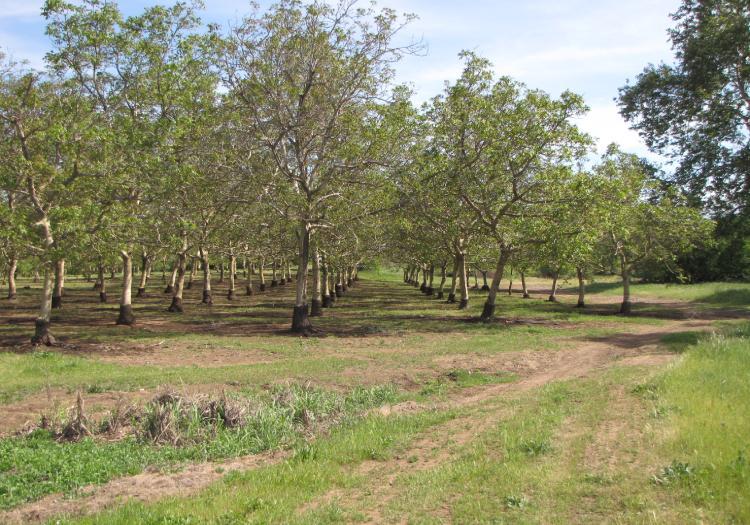
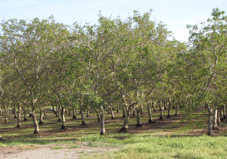
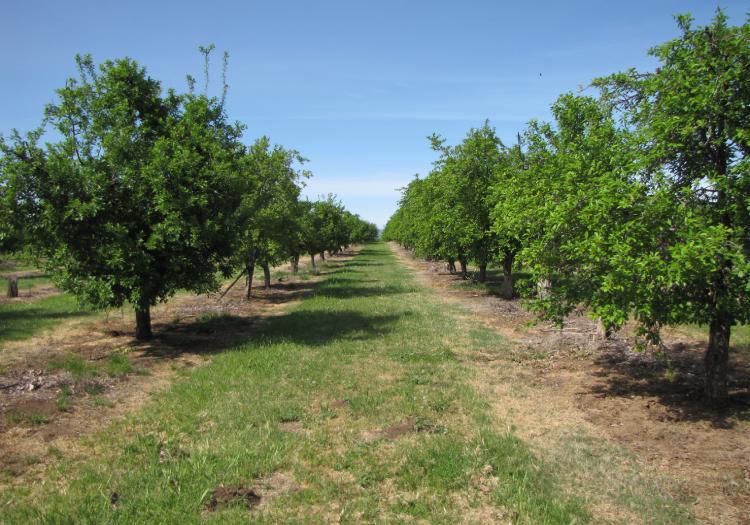
2 AG-LAND INVESTMENT BROKERS 275Sale Lane / P. O. Box 896 Red Bluff, CA office / fax Trees: Approx. 103 acres are planted to bearing French Prune on Mariani rootstock. Approx. 38 acres are planted to bearing English Walnuts on Northern California Black Walnut rootstock. The walnut varieties are primarily Hartley and Vina. The orchards are irrigated by a micro-jet irrigation system with above ground drip tubing. Production : The 10 year APH (Actual Production History) confirmed by NAU Country Insurance for federal crop insurance purposes is 1.4 dry tons per acre for the French prunes and 2,719 in-shell pounds per acre for the English walnuts. Improvements: Located upon the property are (2) homes and numerous barns and shops. There is also (1) double wide mobile home. Presently, the homes and mobile homes are rented. Wildlife: The Dye Creek corridor is a natural haven for wildlife such as Wild Hog, Turkey, Quail and Dove. Depreciation: The improvements on this property such as the trees, irrigation systems and buildings may offer significant deprecation advantages to the prospective Buyer. Mineral Rights: All oil, gas, mineral and water rights owned by Seller will transfer to the Buyer. Crop: Current crops are included in the sale provided Buyer reimburses Seller cultural costs including orchard management fee and crop insurance premiums from 11/01/2012 to close of escrow. Contact Info: Please contact the Listing Brokers, Bert Owens or Sam Mudd. Bert Owens, California Brokers License Number , office / , cell bert.owens@aglandbrokers.com, website Sam Mudd, California Brokers Number , office / , cell sam.mudd@aglandbrokers.com, website The information contained herein is from sources deemed reliable, however, accuracy is not guaranteed. AG-LAND Investment Brokers assumes no liability as to errors, omissions or future operating and investment results. Buyer assumes responsibility to perform their own investigation and due diligence. This offering is subject to prior sale, price change or withdrawal from market without notice.
3


4 AG-LAND Investment Brokers 275 Sale Lane, Suite 2 PO Box 896 Red Bluff, CA Fax
5
6
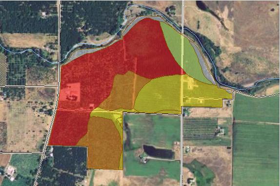
7 Irrigated Capability Class Tehama County, California (Los Molinos Ranch LLC) MAP LEGEND Area of Interest (AOI) Area of Interest (AOI) Soils Soil Map Units Soil Ratings Capability Class - I Capability Class - II Capability Class - III Capability Class - IV Capability Class - V Capability Class - VI Capability Class - VII Capability Class - VIII Not rated or not available Political Features Cities Water Features Streams and Canals Transportation Rails MAP INFORMATION Map Scale: 1:8,780 if printed on A size (8.5" 11") sheet. The soil surveys that comprise your AOI were mapped at 1:20,000. Warning: Soil Map may not be valid at this scale. Enlargement of maps beyond the scale of mapping can cause misunderstanding of the detail of mapping and accuracy of soil line placement. The maps do not show the small areas of contrasting soils that could have been shown at a more detailed scale. Please rely on the bar scale on each map sheet for accurate map measurements. Source of Map: Natural Resources Conservation Service Web Soil Survey URL: Coordinate System: UTM Zone 10N NAD83 This product is generated from the USDA-NRCS certified data as of the version date(s) listed below. Soil Survey Area: Tehama County, California Survey Area Data: Version 6, Jan 6, 2011 Date(s) aerial images were photographed: 6/30/2005 The orthophoto or other base map on which the soil lines were compiled and digitized probably differs from the background imagery displayed on these maps. As a result, some minor shifting of map unit boundaries may be evident. Interstate Highways US Routes Major Roads Local Roads Natural Resources Conservation Service Web Soil Survey National Cooperative Soil Survey 4/9/2013 Page 2 of 4
8 Irrigated Capability Class Tehama County, California Los Molinos Ranch LLC Irrigated Capability Class Irrigated Capability Class Summary by Map Unit Tehama County, California (CA645) Map unit symbol Map unit name Rating Acres in AOI Percent of AOI Af Anita clay, moderately deep % Ao Anita cobbly clay, moderately deep % At Anita-Keefers complex, 0 to 3 percent slopes % Bc Berrendos clay, 0 to 3 percent slopes % Km Mp Keefers loam, moderately deep, 0 to 3 percent slopes Millrace gravelly fine sandy loam, 0 to 3 percent slopes % % Mzt Molinos complex, channeled % Rr Riverwash % Vy Vina clay loam, deep, 0 to 3 percent slopes % Totals for Area of Interest % Natural Resources Conservation Service Web Soil Survey National Cooperative Soil Survey 4/9/2013 Page 3 of 4
9 Irrigated Capability Class Tehama County, California Los Molinos Ranch LLC Description Land capability classification shows, in a general way, the suitability of soils for most kinds of field crops. Crops that require special management are excluded. The soils are grouped according to their limitations for field crops, the risk of damage if they are used for crops, and the way they respond to management. The criteria used in grouping the soils do not include major and generally expensive landforming that would change slope, depth, or other characteristics of the soils, nor do they include possible but unlikely major reclamation projects. Capability classification is not a substitute for interpretations that show suitability and limitations of groups of soils for rangeland, for woodland, or for engineering purposes. In the capability system, soils are generally grouped at three levels-capability class, subclass, and unit. Only class and subclass are included in this data set. Capability classes, the broadest groups, are designated by the numbers 1 through 8. The numbers indicate progressively greater limitations and narrower choices for practical use. The classes are defined as follows: Class 1 soils have few limitations that restrict their use. Class 2 soils have moderate limitations that reduce the choice of plants or that require moderate conservation practices. Class 3 soils have severe limitations that reduce the choice of plants or that require special conservation practices, or both. Class 4 soils have very severe limitations that reduce the choice of plants or that require very careful management, or both. Class 5 soils are subject to little or no erosion but have other limitations, impractical to remove, that restrict their use mainly to pasture, rangeland, forestland, or wildlife habitat. Class 6 soils have severe limitations that make them generally unsuitable for cultivation and that restrict their use mainly to pasture, rangeland, forestland, or wildlife habitat. Class 7 soils have very severe limitations that make them unsuitable for cultivation and that restrict their use mainly to grazing, forestland, or wildlife habitat. Class 8 soils and miscellaneous areas have limitations that preclude commercial plant production and that restrict their use to recreational purposes, wildlife habitat, watershed, or esthetic purposes. Rating Options Aggregation Method: Dominant Condition Component Percent Cutoff: None Specified Tie-break Rule: Higher Natural Resources Conservation Service Web Soil Survey National Cooperative Soil Survey 4/9/2013 Page 4 of 4
10
11
12

13

14