Big Hill Insect and Disease Project Proposed Action
|
|
|
- Willis Peters
- 6 years ago
- Views:
Transcription
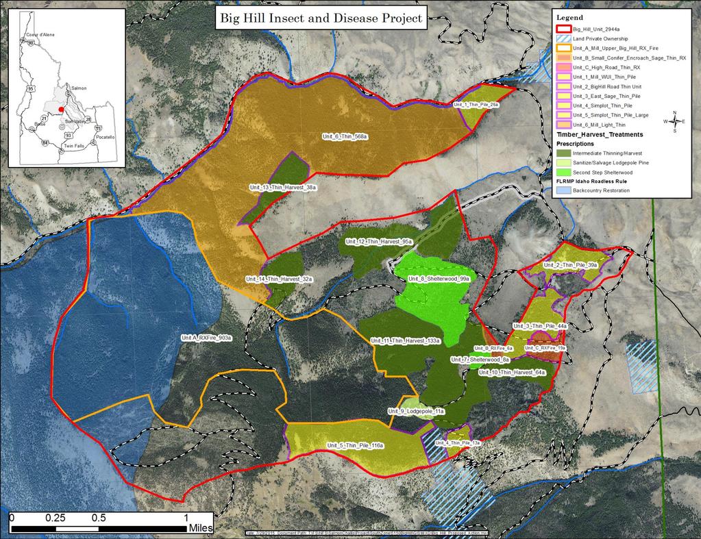
1 Big Hill Insect and Disease Project Proposed Action Project Background and 2014 Farm Bill The Big Hill Insect and Disease project on the Challis-Yankee Fork Ranger District of the Salmon-Challis National Forest was developed to increase forest stand resiliency to insects, disease, and other disturbances, such as wildland fire. The planning area is approximately 3000 acres and is located seven miles west of Challis, Idaho in portions of T14N, R18E (S28-33), T13N, R18E (S3-6), T13N, R17E (S1), T14N, R17E (S36) Boise Meridian, Custer County, ID. On February 7, 2014, President Obama signed into law the Agricultural Act of 2014 (2014 Farm Bill). Among the provisions that pertain to the Forest Service, Section 8204 includes an important provision for addressing insect and disease threats on National Forest System lands. Section 8204 amended Title VI of HFRA to add Sections 602 and 603. Section 603 establishes a categorical exclusion for qualifying insect and disease projects in designated areas. An insect and disease project that may be categorically excluded under this authority is a project that is designed to reduce the risk or extent of, or increase the resilience to insect or disease infestation in the areas (HFRA, Sections 602(d) and 603(a)). This categorical exclusion may be used to carry out an insect and disease project in an insect and disease treatment area designated by the Secretary under section 602. On March 31, 2014, Idaho Governor Butch Otter requested designation of landscape-scale areas on National Forests in Idaho to address insect or disease threats. Based on current insect and disease assessments, the Salmon-Challis National Forest submitted the Big Hill project area through the Governor s Office. On May 20, 2014, Forest Service Chief Tom Tidwell designated the Big Hill project area as eligible under Section 603 of HFRA. Purpose and Need for Action The project area is within the Challis Creek Management Area (#21) of the Challis National Forest Land and Resource Management Plan (Forest Plan). Management prescriptions in this area will emphasis timber production, wildlife and fish habitat, range administration and maintenance of water quality (Forest Plan p. IV-168). Additionally, the project is located within the boundaries of the Challis Creek Watershed Analysis (1997). The Forest Plan identifies desired conditions and management objectives for the planning area. Purpose and need for action is generated by identifying the departure of the existing condition from the desired condition. Policy and regulatory frameworks and consideration of best available science also guide identification of desired condition. The primary need identified for this project is for increased forest stand resiliency to insects and disease and other disturbance agents (biological and physical) within the project area. In the project area, the current coniferous stands, predominantly consisting of Douglas-fir and some mixed conifers, can generally be categorized as being heavily stocked with closed canopies. Multiple disease agents are present throughout, but the dominant disease is Douglas-fir and lodgepole pine mistletoe which is wide spread. The general area in the last decade has experienced elevated levels of bark beetle activity, some to epidemic proportion as was the case with mountain pine beetle that resulted in extensive mortality to lodgepole pine and whitebark pine species in the area. Douglas-fir beetle levels though not epidemic continue to occur, creating pockets of mortality to this present day. The stands within the project area
2 are weakened further when you combine the insect and disease agent with the drought stress taking place in much of the northwest region. Fire behavior modeling, from stand exam and fuels data collected in the project area, indicates if a wildfire is established on a normal summer day, it would become a crown fire. Such a crown fire would pose a significant threat to adjacent private property or homes and to the municipal watershed for Challis in the Garden Creek drainage. In meeting the need, the proposed actions would also do the following for consistency with the Forest Plan and/or policy or regulatory framework: Timber: Integrate appropriate forest pest management strategies into timber management and; Enhance timber species diversity and age structure within each Management Area. (Forest Plan p. IV-16) Treatment of Fuel and Other Vegetation: Reduce fire potential in high hazard, high value areas by a) fuelwood programs, b) fuels treatments, and c) fire breaks. (Forest Plan p.iv-29) Protection: Use prescribed fire to accomplish resource management objectives (Forest Plan p. IV-8). Proposed Action Finalized proposed actions were developed for the project and approved by the District Ranger Katherine Wood. The finalized proposed actions were based on public meetings (June 30th and July 11th 2015), project site visits, and comments received from interested parties. Objectives of the proposed action are to create stands that are resilient to insect and disease agents and reduce hazardous fuels. The proposed action consists of the following general activities: 1. Thinning for fuels reduction (harvest, pile, and/or lop/scatter) 2. Thinning for aspen restoration (harvest, pile, and/or lop/scatter) 3. Thinning for timber stand Improvement (harvest, pile, and/or lop/scatter) 4. Prescribed fire for fuels reduction, aspen restoration, or timber stand improvement (broadcast and pile) Portions of these activities will overlap in space and/or time. Prescribed fire is the only activity planned in the area of the project designated as backcountry restoration by the Idaho Roadless Rule. No mechanical treatments (thinning) will take place in this area other than incidental mechanical activities that support prescribed fire. No additional activities from this project are planned in the ongoing whitebark pine restoration area in the Southwest section of the project area. Below are further specifics on the activities that will be implemented by the proposed action: 1. Implement a thinning cut across approximately 1,286 acres using chainsaws or mechanical ground-based equipment such as feller-bunchers or processors. Thinning would involve the removal of live and dead conifer trees of most species and size classes (but not large, fireresistance trees) and without regards to canopy position, but with consideration for crown condition (dwarf mistletoe and western spruce budworm damage) and the potential for future tree and stand growth and/or vigor. This activity is not intended to result in change of cover 2
3 type (species composition of the dominant overstory trees), but is intended to result in the conversion of stagnant stands into actively growing stands through reduction in density. Units Implement the Second-step of Shelterwood with retention across 107 acres using chainsaws or mechanical ground-based equipment such as feller-bunchers or processors. Commercial harvest would involve reducing overstory tree spacing in half (from 17 X 17 to 30 by 30 ) favoring large disease free trees with desirable phenotypical characteristics of actively growing trees (crowns greater than 40%, bottom boles grey in color, top boles smooth silver in color, and not exhibiting flattening tops). Retain all legacy tree (exhibiting old characteristics) for future snags. Regeneration is already established and further reduction of overstory will enhance growth of these stands. This activity is not intended to result in a changes of cover type (species composition of the dominant overstory trees) but is intended to result enhance the growth of advance regeneration by providing more sunlight and less competition. Units 7 and Implement an aspen restoration cut across approximately 237 acres using chainsaws. This would generally occur in stands with aspen present but being overtaken with conifers, in order to promote aspen vigor and regeneration to their historical range. The aspen restoration cut, which is analogous to a group selection cut, is an multi-aged regeneration method in which live and dead conifer trees are cut in small groups and new age classes are established. The width of group selection cut is achieved by removing conifers for 150 from all live aspens. Regeneration would generally be dominated by aspen, an early-seral species, but may be dominated by lodgepole pine or Douglas-fir where existing aspen are not present. Where aspen and conifers co-dominate the seedling/sapling stage of the understory, hand chainsaws or pruning shears would be used to remove the conifers. Individual conifers of all size classes within areas outside of created openings would also be harvested to provide improved growing conditions for the remaining conifers or aspen, and reduce hazardous fuels. In most areas where groups of trees are harvested and openings are created, this activity is intended to result in changes of cover type (species composition of the dominant overstory trees) from Douglas-fir and lodgepole pine cover types to aspen cover types. The non-group matrix within cutting units would be intended to remain as cover types of conifer species. All affected stands are intended to remain in the Young Multi-strata Forest structure class. Aspen restoration would occur in portions of units 3, 8, and 12. Fencing for protection would occur for the large aspen stand in the center of unit 12 and may be recommended for additional small stands in units 3 and Implement broadcast and pile burning across approximately 2,214 acres, which includes areas affected by the tree cutting activities described above. Broadcast burning would burn in a patchy mosaic and reduce fuels across 30-60% of the proposed burn units. Fires would occur within a range of severities, ranging from low (<25% canopy mortality) to high (>75% mortality). This would create a fine-scale; topographically-driven mosaic of vegetation species assemblages and structural stages, and reduce fuel loads across much of the burn area. Where fire occurs and burns with moderate or high severity among habitat types where aspen and whitebark pine 3
4 occur, this treatment would create conditions more suitable for aspen and whitebark pine regeneration. Burning activities would remove a variety of tree species, from all size classes, depending on burn intensity and tree species resistance to fire effects. Broadcast burning treatments would be repeated as needed in dry Douglas-fir habitat types approximately every years. Broadcast burning would be the primary activity for units A, B, C, and 6 (1496 acres). Prior thinning (lop and scatter) in Units B, C, and 6 will be done for the purpose of supporting and facilitating broadcast burning. Pile burning will occur across approximately 238 acres. This will treat piled fuels in units 1,2,3,4, and 5. Broadcast burning will be used as a follow-up activity after thinning and/or pile burning in units 1-5 and Roads: No new construction of permanent roads would occur. Maintenance and repairs will occur on open roads as described in the Salmon-Challis National Forest Motor Vehicle Use Map (2014) where needed to allow for harvest activities. In addition, up to one mile of temporary roads may be constructed to access harvest units. Temporary roads will be constructed using national and regional harvest temporary road Best Management Practices (BMP s). Once harvest activities are complete all temporary roads and designated unclassified roads will be fully decommissioned as stated in the design features within three years of last date of harvest. Unclassified roads that will be selected for decommission are roads used as haul roads and unclassified roads that are present within perennial or intermittent stream RHCA s. Large Tree Retention: The project will maximize the retention of large trees. Legacy trees will be retained in the project area. Legacy trees can be defined as largest mature trees that have survived multiple disturbance events such as wildland fire, insect activity, and human activities. Harvest and thinning activities will favor the largest trees with lowest disease severity. Slash Treatments: For harvest areas some slash will need to be left for long term site productivity. Acceptable amounts should not exceed 7 tons per acre within any Wildland Urban Interface. Burning will need to take place post-harvest to address landing piles and may be needed to treat harvest generated slash across these area. For landings piles that are burned a follow up will occur to scarify and seed with native seed to return landings to pre-harvest conditions. To prevent unauthorized motorized use of skid trails, slash will be scatter along these routes making them impassable to those vehicles. Project Schedule and Duration: Implementation is expected to begin in the summer of 2016 and potentially extend up to ten years to complete all activities. For majority of the units, prescribe fire activities will be postponed until other proposed treatments have been accomplished (thin and pile) to adjust fuel conditions for a successful and safe burn within prescription windows and boundaries. 4
5 Big Hill Insect and Disease Unit Descriptions Acres Existing Condition Prescription Unit Number 1 26 Mixed conifer stand dominated by Douglas-fir. Of the Douglas-fir overstory approximately 50% are infected with Douglas-fir mistletoe propagating this disease agent into the understory Mixed conifer stand dominated by Douglas-fir. Of the Douglas-fir overstory approximately 30% of overstory is infected with Douglas-fir mistletoe propagating this disease agent into the understory Mixed conifer stand dominated by Douglas-fir. Of the Douglas-fir overstory approximately 30% of overstory is infected with Douglas-fir mistletoe propagating this disease agent into the understory. Several small aspen stand occur within the unit on the west and north portions of the stand Mixed conifer stand located at higher elevation in the basin containing subalpine fir and whitebark pine Mixed conifer stand located at higher elevation in the basin containing subalpine fir and whitebark pine. Reduce stems to approximately 150 trees per acre through overstory and understory thinning. Piling of slash will follow and concurrent with thinning activities. Retain all legacy trees. Favor for retention trees that are insect and disease free. Reduce stems per to approximately 150 trees per acre through overstory and understory thinning. Piling of slash will follow and concurrent with thinning activities. Retain all legacy trees. Favor for retention trees that are insect and disease free. Implement aspen restoration protocol where aspen is present. Reduce stems to roughly 150 trees per acre through overstory and understory thinning. Piling of slash will follow and concurrent with thinning activities. Retain all legacy trees. Favor for retention trees that are insect and disease free. Reduce stems to roughly 150 trees per acre through overstory and understory thinning. Piling of slash will follow and concurrent with thinning activities. Retain all legacy trees. Favor for retention trees that are insect and disease free. Reduce stems to roughly 150 trees per acre through overstory and understory thinning. Piling of slash will follow and concurrent with thinning activities. Retain all legacy trees. Favor for retention trees that are insect and disease free. 5
6 Unit Acres Existing Condition Prescription Number Mixed conifer stand dominated by Douglas-fir. Through the Douglas-fir overstory more than 50% of these trees are infected with Douglas-fir mistletoe propagating the disease agent into the understory. Thin (lop and scatter) areas of continuous and high densities of Douglas-fir mistletoe to the extent needed to facilitate consumption of understory and overstory to meet desired burn objectives. Burn objectives are to achieve a 30-60% mosaic burn pattern across the unit changing the current continuous fuels and disrupting potential for continuous crown fire. Expect fire results would occur within a range of severities through the trees, ranging from low (<25% canopy mortality) to high (>75% mortality). Multiple entries within different time and space will be needed to achieve desired results. Entries preference would occur progressively from the east end of the unit working towards the west. 7 8 Two-storied mixed conifer stand dominate by Douglas-fir. Of the Douglas-fir overstory approximately 50% are still infected with Douglas-fir mistletoe propagating this disease agent into the understory. Implement second step of shelterwood. Reduce overstory in half by removal of the existing infected trees and other non-infected trees to achieve desired spacing and release understory. Where infection is not present favor large trees that exhibit excellent growth characteristics for retention. If legacy trees are still present retain them for future snag. Postharvest sanitize understory removing regeneration that exhibits Douglas-fir 8 99 Two-storied Douglas-fir stand. Douglasfir overstory with advance regeneration underneath. 30% of the overstory is still infected with Douglas-fir mistletoe propagating this disease agent into the understory. Several small aspen stand occur within the unit on the west and north portions of the stand. Overstory constitutes approximately 150 trees per acre. mistletoe. Implement aspen restoration protocol where aspen is present of radial thinning all conifers within 150. Outside aspen area implement second step of a shelterwood and further reduce number of overstory trees. Reduce overstory in half by removal of the existing infected trees and other noninfected trees to approximately 30 by 30 spacing (50-75 overstory trees per acre). Where infection is not present favor large trees that exhibit excellent growth characteristics for retention. If legacy trees are still present retain them for future snag. Post-harvest sanitize understory removing that regeneration that exhibits Douglas-fir mistletoe. Consider fencing of aspen stands. 6
7 Unit Acres Existing Condition Prescription Number 9 11 Mixed conifer stand with significant lodgepole pine mortality as a result of previous mountain pine beetle epidemic. In the near past and presently area has provided personal use fuelwood and dead roundwood products. future growth Mixed conifer stand dominated by small diameter Douglas-fir (500+stems/acre). Majority of large trees were high grade at the turn of the century to provide lumber to newly establish community of Challis or to supply mine timbers to the fledging mining activity. Harvesting of only big trees release the regeneration that was present creating a stand with a few large trees with a significant amount of small diameter trees Douglas-fir tree stand with minor components of mixed conifer in the upper elevation on the Southwest side. Douglas-fir (500+stems/acre). Majority of large trees were high grade at the turn of the century to provide lumber to newly establish community of Challis or to supply mine timbers to the fledging mining activity. Harvesting of only big trees release the regeneration that was present creating a stand with a few large trees with a significant amount of small diameter trees. Expand opportunities in and around the vicinity for continue sanitization and salvage of lodgepole pine. Where access is limited consider offering small sales to the public to remove these products authorizing ground based mechanize systems for removal off existing roads. Allow the activity to continue for approximately 5 years. Post five years conduct thin from below activity sanitizing stand and establishing favorable conditions for Reduce stems per acre to roughly 175 through harvest and understory thinning. Retain all legacy trees. Favor for retention trees that are insect and disease free. Salvage the dead lodgepole pine that is scattered throughout the stand. Understory thinning will take place after harvest. Anticipated this will be a significant number allow free use firewood of the stand to further reduce this ground fuel. Reduce stems per acre to roughly 175 through harvest and understory thinning. Retain all legacy trees. Favor for retention trees that are insect and disease free. Salvage the dead lodgepole pine that is scattered throughout the stand. Understory thinning will take place after harvest. Pile post-harvest understory thinning slash except near existing roads and burn. 7
8 Unit Acres Existing Condition Prescription Number Dichotomous stand dominated by Douglas-fir but approximately 1/3 of stand area is an aspen stand being taken over by conifers. Implement aspen protocol where present. Outside aspen areas thin residual stand down to approximately 150 trees per acre through harvest and post-harvest activity. Favor large trees and retain all legacy trees present in the stand except near aspen. Within the commercial component favor for retention trees that are free of Douglas-fir dwarf mistletoe and free of damage from western spruce budworm. Commercial harvest during frozen ground conditions is the proposed treatment to limit resource damage Douglas-fir tree stand located at the top 1/3 of the slope. Reduce trees per acre to 125 or 24 by 24. Favor large trees that are free of Douglas-fir dwarf mistletoe or western spruce budworm damage. Where legacy trees are present retain for future snags Douglas-fir tree stand located at the top 1/3 of the slope. A 903 Mixed conifer stands. Primarily Douglasfir at lower elevations switching to heavier subalpine fir and whitebark pine at higher elevations. B 6 Scattered conifer encroachment into Grass/sage community. Small component of adjacent open grass/sage community. C 19 Scattered conifer encroachment into Grass/sage community. Small component of adjacent open grass/sage community. Reduce trees per acre to 125 or 24 by 24. Favor large trees that are free of Douglas-fir dwarf mistletoe or western spruce budworm damage. Where legacy trees are present retain for future snags. Broadcast burn to achieve 30-60% mosaic burned area across unit. Fires would occur within a range of severities, ranging from low (<25% canopy mortality) to high (>75% mortality). This would create a fine-scale; topographically-driven mosaic of vegetation species assemblages and structural stages, and reduce fuel loads across much of the burn area. Ignition of unit will be by aerial and hand ignition. Thinning of all conifers with the exception of legacy trees. Lop and scatter of thinning slash followed by broadcast burn to promote continuity and age diversity of unit and adjacent grass and sage. Thinning of all conifers with the exception of legacy trees. Lop and scatter of thinning slash followed by broadcast burn to promote continuity and age diversity of unit and adjacent grass and sage. 8
9 9
Kurtis Robins District Ranger US Forest Service 138 S Main
 United States Department of Agriculture Forest Service Fishlake National Forest Fax: (435) 836-2366 138 S Main, PO Box 129 Loa, UT 84747 Phone: (435) 836-2811 File Code: 1950 Date: April 5, 2011 Kurtis
Appendix A: Vegetation Treatments
 Appendix A: Vegetation Treatments In general, the proposed actions for the Light Restoration project focuses on establishing the composition, structure, pattern, and ecological processes necessary to make
Appendix A Silvicultural Prescription Matrix Spruce Beetle Epidemic and Aspen Decline Management Response
 Appendix A Silvicultural Prescription Matrix Spruce Beetle Epidemic and Aspen Decline Management Response Treatment objectives within the matrix are a combination of objectives for silvicultural, fuels,
PRESCRIBED FIRE IN SOUTHWEST IDAHO
 2016 PRESCRIBED FIRE IN SOUTHWEST IDAHO In southwest Idaho, public land managers work to: address public health and safety concerns; treat insect and disease infestations; reduce the risk of severe wildfires
BOISE FOREST COALITION MEETING BOGUS BASIN UPDATE
 BOISE FOREST COALITION MEETING BOGUS BASIN UPDATE WELCOME AND INTRODUCTIONS Idaho Department of Fish and Game 600 S. Walnut, Boise, Idaho Trophy Room October 15, 2015 Facilitators, Dick Gardner and Jim
Dear Interested Party:
 United States Department of Agriculture Forest Service Beaverhead-Deerlodge National Forest 420 Barrett Street Dillon, MT 59725 406 683-3900 File Code: 1950 Date: June 7, 2011 Dear Interested Party: Thank
Dear Interested Party,
 United States Department of Agriculture Forest Service Gunnison Ranger District 216 N Colorado St. Gunnison, CO 81230 Voice: 970-641-0471 TDD: 970-641-6817 File Code: 1950-1/2430 Date: June 8, 2010 Dear
APPENDIX A VEGETATION RESTORATION TREATMENT SUMMARY ABBREVIATIONS USED IN THE HARVEST TREATMENT SUMMARY TABLES
 APPENDIX A VEGETATION TREATMENTS APPENDIX A VEGETATION RESTORATION TREATMENT SUMMARY This table provides information about the proposed treatment units including the existing conditions, the proposed treatment,
CATEGORICAL EXCLUSION WORKSHEET: RESOURCE CONSIDERATIONS
 CATEGORICAL EXCLUSION WORKSHEET: RESOURCE CONSIDERATIONS Developed Recreation/Trails, Wilderness & Roadless Jasper Mountain Priest Lake Ranger District Idaho Panhandle National Forest Description of the
Rock Creek Fuels and Vegetation Project
 United States Department of Agriculture Forest Service November 2014 Rock Creek Fuels and Vegetation Project Minidoka Ranger District, Sawtooth National Forest Cassia and Twin Falls Counties, Idaho Image
Hyde Park Hyde Park Wildland Urban Interface Project. Scoping Information February 2017
 Introduction The Santa Fe National Forest is working as part of the Greater Santa Fe Fireshed Coalition (GSFF) to change conditions across a landscape critical to the vitality of our communities. The GSFF
Idaho Panhandle National Forests
 United States Department of Agriculture Forest Service Idaho Panhandle National Forests St. Joe Ranger District 222 S. 7 th St. Suite 1 St. Maries, ID 83861 (208) 245-2531 File Code: 1950 Date: January
File Code: 1950 Date: March 22, 2011
 United States Department of Agriculture Forest Service Mt. Hood National Forest Barlow Ranger District 780 NE Court Street Dufur, OR 97021 541-467-2291 FAX 541-467-2271 File Code: 1950 Date: March 22,
Telegraph Forest Management Project
 Telegraph Forest Management Project Black Hills National Forest Northern Hills Ranger District Lawrence and Pennington Counties, South Dakota Proposed Action and Request for Comments March 2008 Table of
Vestal Project Proposed Action Hell Canyon Ranger District Black Hills National Forest April 2011
 Vestal Project Proposed Action Hell Canyon Ranger District Black Hills National Forest April 2011 Introduction: The Vestal Project area is located surrounding the city of Custer, South Dakota within Custer
Nez Perce National Forest Moose Creek Ranger District
 United States Department of Agriculture Forest Service Nez Perce National Forest Moose Creek Ranger District 831 Selway Road Kooskia, ID 83539 208 926-4258 TTY 208 926-7725 File Code: 1950 Date: Dec 30,
Sheppard Creek Post-Fire Project
 Flathead National Forest Tally Lake Ranger District Sheppard Creek Post-Fire Project Purpose of the Project and Proposed Action December 14, 2007 This document presents information about the Brush Creek
Introduction. Methodology for Analysis
 1 Medicine Lake Caldera Vegetation Treatment Project Scenic Report Prepared by: /s/gary Kedish Natural Resources Specialist for: Big Valley and Doublehead Ranger Districts Modoc National Forest February
File Code: 1950 Date: November 17, 2015
 Logo Department Name Agency Organization Organization Address Information United States Forest Deschutes National Forest 63095 Deschutes Market Road Department of Service Bend/Fort Rock Ranger District
Boulder Ranger District
 United States Department of Agriculture Forest Service Boulder Ranger District 2140 Yarmouth Avenue Boulder, CO 80301-1615 Voice: (303) 541-2500 Web: www.fs.usda.gov/arp Fax: (303) 541-2515 File Code:
Taylor and Stoner Mesas Vegetation Management Project Scoping Package
 Taylor and Stoner Mesas Vegetation Management Project Scoping Package The Forest Service is seeking input and ideas regarding a vegetation management proposal on the Dolores Ranger District of the San
Appendix J. Forest Plan Amendments. Salvage Recovery Project
 Forest Plan Amendments Salvage Recovery Project APPENDIX J Lynx and Old Growth Forest Plan Amendments CHANGES BETWEEN DRAFT EIS AND FINAL EIS Changes in Appendix J between the Draft and Final EIS include:
Dwarf Mistletoe Biology and Management in Southeast Region
 Dwarf Mistletoe Biology and Management in Southeast Region Louis Halloin February 2003 Dwarf mistletoe is a parasitic plant native to western forests. It depends on its host for water and nutrients. Mistletoe
Reading Project Noxious Weed Risk Assessment Hat Creek Ranger District Lassen National Forest April 3, 2013
 Reading Project Noxious Weed Risk Assessment Hat Creek Ranger District Lassen National Forest April 3, 2013 Prepared By: /s/ Tim Kellison Date: 05-31-2013 Tim Kellison Assistant Forest Botanist Reviewed
Medicine Bow Landscape Vegetation Analysis (LaVA) Cooperating Agency Meeting March 6, :30 a.m. 12:30 p.m.
 Cooperating Agency Meeting March 6, :30 a.m. 12:30 p.m.") Medicine Bow Landscape Vegetation Analysis (LaVA) Cooperating Agency Meeting March 6, 2017 9:30 a.m. 12:30 p.m. Condition-based NEPA A Cutting-edge Analysis Approach What it s Not What it Is How it Works
Medicine Bow Landscape Vegetation Analysis (LaVA) Cooperating Agency Meeting March 6, 2017 9:30 a.m. 12:30 p.m. Condition-based NEPA A Cutting-edge Analysis Approach What it s Not What it Is How it Works
Walton Lake Restoration Project
 Walton Lake Restoration Project Fire and Fuels Specialist Report, February 2017 Ochoco National Forest Lookout Mtn. Ranger District Barry Kleckler Fuels Specialist, Prairie Division, Central Oregon Fire
Wildlife Conservation Strategy
 Wildlife Conservation Strategy Boise National Forest What is the Wildlife Conservation Strategy? The Boise National Forest is developing a Wildlife Conservation Strategy (WCS) in accordance with its Land
Notes for Smith Shields Public Meeting & Field Trip
 Notes for Smith Shields Public Meeting & Field Trip July 27 & 29, 2016; Livingston, MT and Project Area These notes are intended to capture the broader topics, issues and concerns discussed at the public
Acres within Planning Area. Total Acres Burned
 Calf-Copeland Project Description Figure 1: Dead sugar pine in the Calf-Copeland planning area. Sugar pine grow best in open conditions. In the absence of fire disturbance, high densities of Douglas-fir
Prescribed Fire Prescription 1. MP: 43 ac UB: 167 ac Landings: 21
 Appendix A: Proposed Thinning and Prescribed Fire Treatments This appendix contains parameters and prescriptions applicable to proposed commercial and non-commercial thinning treatments and prescribed
FISHLAKE NATIONAL FOREST BEAVER RANGER DISTRICT BIOLOGICAL ASSESSMENT. for. THREATENED, ENDANGERED or CANDIDATE WILDLIFE SPECIES.
 FISHLAKE NATIONAL FOREST BEAVER RANGER DISTRICT BIOLOGICAL ASSESSMENT for THREATENED, ENDANGERED or CANDIDATE WILDLIFE SPECIES for the Big Flat Vegetation Management Project Prepared By: /s/ Steve Flinders
File Code: 1950 Date: September 13, 2017
 United States Department of Agriculture Forest Service Darby-Sula Ranger District 712 N. Main Street Darby, MT 59829 406-821-3913 File Code: 1950 Date: September 13, 2017 The Bitterroot National Forest
Introduction. Methodology for Analysis
 Scenic Report Prepared by: /s/gary Kedish Natural Resources Specialist for: Warner Mountain Ranger District Modoc National Forest January 20, 2016 Introduction This report focuses on the Visual Quality
Sawmill Vegetation Management Project Environmental Assessment
 Sawmill Vegetation Management Project Environmental Assessment HYDROLOGY/SOILS SPECIALIST TECHNICAL REPORT Prepared by: David Deschaine Hydrologist, Salmon-Challis National Forest Intermountain Region
Forsythe II Project. September 2015
 Forsythe II Project September 2015 The Boulder Ranger District (BRD) of the Arapaho and Roosevelt National Forests is proposing vegetation treatments on 3,840 acres of National Forest System (NFS) lands
Prescribed Fire Prescription 1. MP: 43 ac UB: 167 ac Landings: 21
 Appendix A: Proposed Thinning and Prescribed Fire Treatments This appendix contains parameters and prescriptions applicable to proposed commercial and non-commercial thinning treatments and prescribed
Elkhorn Project Proposed Action
 Elkhorn Project Proposed Action PROJECT LOCATION The Elkhorn project area is defined by the Cache la Poudre River and Highway 14 to the south, the Manhattan Road (CR 69) to the east, the Deadman Road to
1. Protect against wildfires 2. Enhance wildlife habitat 3. Protect watersheds 4. Restore plant communities. Ford Ridge Project Area (pre-treatment)
") OVERVIEW Ford Ridge is a multi-stage project planned and coordinated utilizing indepth scientific research and best management practices. Project implementation began in the spring of 2015, with additional
OVERVIEW Ford Ridge is a multi-stage project planned and coordinated utilizing indepth scientific research and best management practices. Project implementation began in the spring of 2015, with additional
CHAPTER 1 - PURPOSE & NEED
 CHAPTER 1 - PURPOSE & NEED BACKGROUND The need for action in the Falls Meadowbrook area is based upon the results of the following analyses: The 2004 Potamus Watershed Analysis An analysis of the existing
Decision Memo for Pax Ponderosa Pine Planting Project
 Decision Memo for Pax Ponderosa Pine Planting Project USDA Forest Service Pacific Northwest Region Fremont-Winema National Forests Lakeview Ranger District Lake County, Oregon Introduction The Lakeview
ROCK CREEK FUELS AND VEGETATION PROJECT FORESTED VEGETATION ANALYSIS Karl Fuelling 9/18/2015
 ROCK CREEK FUELS AND VEGETATION PROJECT FORESTED VEGETATION ANALYSIS Karl Fuelling 9/18/2015 CURRENT CONDITIONS The vegetation analysis for the Rock Creek project has been done using Arcmap with Vegetation,
Q&A: Omineca spruce beetle outbreak May 4, 2018
 Q&A: Omineca spruce beetle outbreak May 4, 2018 Q. How big is this outbreak? What kind of impact has it had so far? The most recent provincial aerial overview survey was completed in fall 2017 and found
NEPA Template for White Bark Pine (WBP) Projects 11 March 2014
 Projects 11 March 2014") NEPA Template for White Bark Pine (WBP) Projects 11 March 2014 Steve Shelly, Regional Botanist & R1 WBP IDT U.S. Forest Service Region 1 Mark Skinner, Regional Botanist U.S. Forest Service Region 6 Aly
NEPA Template for White Bark Pine (WBP) Projects 11 March 2014 Steve Shelly, Regional Botanist & R1 WBP IDT U.S. Forest Service Region 1 Mark Skinner, Regional Botanist U.S. Forest Service Region 6 Aly
Idaho Panhandle National Forests
 United States Department of Agriculture Forest Service Idaho Panhandle National Forests St. Joe Ranger District 222 S. 7 th St. Suite 1 St. Maries, ID 83861 (208) 245-2531 File Code: 1950 Date: February
Clara Unit Card. Alternative 2 Acres: 19 Treatment Acres: 6 Stand Age: 106 Primary ELT: 16. Primary Treatment: Single-Tree Selection
 Unit: 7-013-014 Total BA: 62 Forest Type: Quaking Aspen New Forest Type: Aspen/W.Spruce/Fir Primary Treatment: Single-Tree Selection Acres: 19 Treatment Acres: 6 Stand Age: 106 Primary ELT: 16 Treatment
Black Spruce- Lowland. Tower Birch Clearcut-w/Reserves Adjacent 6/5/2019
 Minnesota Department of Natural Resource Division of Forestry 500 Lafayette Road St. Paul, MN 55155-4044 February 08, 2018 Notice of Annual Plan Additions Fiscal Year 2019 Harvest Plan Addition 4 This
Appendix J-1 Marking Guidelines Alternative 4 GTR 220
 Appendix J-1 Marking Guidelines Alternative 4 GTR 220 General Principles The Alternative 4 of the KREW Project is implementing the landscape, ecological vision of An Ecosystem Management Strategy for Sierran
Appendix A (Project Specifications) Patton Mill Fuel Break Project
 Patton Mill Fuel Break Project") Appendix A (Project Specifications) Patton Mill Fuel Break Project I. Proposed Actions: A. Construct a Fuel Break (approximately 5 miles, about 120 acres): The fuel break is located along a segment of
Appendix A (Project Specifications) Patton Mill Fuel Break Project I. Proposed Actions: A. Construct a Fuel Break (approximately 5 miles, about 120 acres): The fuel break is located along a segment of
3.15 SNAG AND SNAG ASSOCIATED SPECIES
 3.15 SNAG AND SNAG ASSOCIATED SPECIES 3.15.1 Scope of the Analysis Snags play an important role in creating biodiversity on the landscape. They provide holes that are homes for birds and small mammals,
Proposed Action Report Big Creek WBP Enhancement Project
 Proposed Action Report Big Creek WBP Enhancement Project USDA Forest Service Cascade Ranger District Boise National Forest Valley County, Idaho July 2013 PURPOSE AND NEED FOR THE PROPOSED ACTION The encroachment
Outlook Landscape Diversity Project
 Appendix D. Vegetation Landscape Diversity Project Prepared by: Lisa Helmig Forest Silviculturist for: Middle Fork Ranger District Willamette National Forest June 1, 2015 Appendix D Table 1 Integrated
3.14 VISUAL RESOURCE (SCENERY)
") 3.14 VISUAL RESOURCE (SCENERY) 3.14.1 INTRODUCTION The Lower West Fork analysis area lies in the Bitterroot Mountain Range and is bisected by the West Fork Road (State Highway 473). The Lower West Fork
3.14 VISUAL RESOURCE (SCENERY) 3.14.1 INTRODUCTION The Lower West Fork analysis area lies in the Bitterroot Mountain Range and is bisected by the West Fork Road (State Highway 473). The Lower West Fork
2015 Insect and Disease Update for Rocky Mountain. Region
 2015 Insect and Disease Update for Rocky Mountain Bob Cain USDA Forest Service State and Private Forestry and Tribal Relations Forest Health Protection Region Mountain Pine Beetle Spruce beetle Douglas-fir
The Galton Project Kootenai National Forest. The Galton Project
 Introduction The Galton Project The Fortine Ranger District of the Kootenai National Forest is in the early stages of developing a project entitled Galton, named for the mountain range dominating the eastern
Idaho Panhandle National Forests
 United States Department of Agriculture Forest Service Idaho Panhandle National Forests Sandpoint Ranger District 1602 Ontario Road Sandpoint, ID 83864-9509 (208)263-5111 File Code: 1950 Date: July 14,
DECISION MEMO MANHATTAN FUELS REDUCTION PROJECT U.S. FOREST SERVICE CANYON LAKES RANGER DISTRICT LARIMER COUNTY, CO
 DECISION MEMO MANHATTAN FUELS REDUCTION PROJECT U.S. FOREST SERVICE CANYON LAKES RANGER DISTRICT LARIMER COUNTY, CO Background and Project Description In order to improve forest health and reduce hazardous
Supplemental Silviculture Report for Cold Canal Vegetation Project Wallowa-Whitman N.F. Wallowa Valley Ranger District
 Supplemental Silviculture Report for Cold Canal Vegetation Project Wallowa-Whitman N.F. Wallowa Valley Ranger District Location: T03S-R45&46E-Multiple Sections County: Wallowa Fifth Field Watershed: Lower
ATTACHMENT 4: DESCRIPTION OF TREATMENT TYPES MESABI PROJECT
 ATTACHMENT 4: DESCRIPTION OF TREATMENT TYPES MESABI PROJECT Treatment Description Photo Example Create young forest with harvest Primary Treatments Two Age Cut Harvest is designed to maintain and regenerate
Bemidji Aspen Clearcut-Artificial Regen Cooperation 1/11/2019
 Minnesota Department of Natural Resource Division of Forestry 500 Lafayette Road St. Paul, MN 55155-4044 December 14, 2018 Notice of Annual Plan Additions Fiscal Year 2019 Harvest Plan Addition No. 3 This
Poker Chip Project. Noxious Weed Risk Assessment Almanor Ranger District Lassen National Forest
 Noxious Weed Risk Assessment Almanor Ranger District Lassen National Forest June 3, 2013 Introduction When a ground-disturbing action or activity is proposed, a Noxious Weed Risk Assessment (NWRA) determines
Appendix A: Vegetation Treatment Descriptions and Unit Specific Design Criteria
 Appendix A: Vegetation Treatment Descriptions and Unit Specific Design Criteria The table below describes the Kabetogama Project proposed vegetation treatments associated with Alternative 2. The treatment
Walla Walla Ranger District
 United States Department of Agriculture Forest Service Walla Walla Ranger District 1415 West Rose Walla Walla, WA 99362 509-522-6290 File Code: 1950 Date: September 30, 2014 Dear Forest User: The Walla
The Project Area. Coeur d'alene River Ranger District. Idaho Panhandle National Forest. P. O. Box 159 Smelterville, ID 83868
 United States Department of Agriculture Forest Service Idaho Panhandle National Forest Coeur d'alene River Ranger District P. O. Box 159 Smelterville, ID 83868 2502 East Sherman Avenue Coeur d' Alene,
Forsythe II Project Proposed Action
 The Boulder Ranger District (BRD) of the Arapaho and Roosevelt National Forests (ARNF) is proposing management activities on 3,901 acres of National Forest System (NFS) lands within the Forsythe II project
Fontana Project Scoping Record August 2013
 Fontana Project Scoping Record August 2013 The Cheoah Ranger District, Nantahala National Forest, is conducting an interdisciplinary analysis of a proposed project, called the Fontana Project, in Graham
Willow Creek Salvage and Fuels Reduction Project
 Decision Notice and Finding of No Significant Impact March 2009 USDA Forest Service Sulphur Ranger District, Arapaho and Roosevelt National Forests & Pawnee National Grassland Grand County, Colorado Introduction
PIPESTONE TIMBER SALE AND RESTORATION PROJECT RECORD OF DECISION
 PIPESTONE TIMBER SALE AND RESTORATION PROJECT RECORD OF DECISION TABLE OF CONTENTS I. BRIEF DESCRIPTION OF MY DECISION... 2 II. OVERVIEW OF THE PROJECT AREA... 3 III. OVERVIEW OF OUR ANALYSIS AND DECISION
Proposed treatments of planted white pine in the Waynesville Watershed
 Proposed treatments of planted white pine in the Waynesville Watershed Peter Bates and Rob Lamb in collaboration with The Waynesville Watershed Advisory Committee September 14, 2010 Presentation overview
DECISION NOTICE, FINDING OF NO SIGNIFICANT IMPACT, and FINDING OF NON-SIGNIFICANT AMENDMENT for the
 DECISION NOTICE, FINDING OF NO SIGNIFICANT IMPACT, and FINDING OF NON-SIGNIFICANT AMENDMENT for the LOWER SHEEP TIMBER SALE and FIRE REINTRODUCTION PROJECT USDA Forest Service Umatilla National Forest
Wildlife Conservation Society Climate Adaptation Fund 2014 Restoring Oak Resilience at the Table Rocks, Rogue River Basin, Oregon FACT SHEET
 Wildlife Conservation Society Climate Adaptation Fund 2014 Restoring Oak Resilience at the Table Rocks, Rogue River Basin, Oregon FACT SHEET Project Overview Oak ecosystems in the Pacific Northwest exist
SILVICULTURE SILVICULTURE 10/8/2018. Ecological forestry (Ecosystem management)
") SILVICULTURE SILVICULTURE Dave Peterson University of Washington School of Environmental and Forest Sciences Thanks to Kristi McClelland, Boyd Evison, and Greg Ettl Silviculture The science and art of
SILVICULTURE SILVICULTURE Dave Peterson University of Washington School of Environmental and Forest Sciences Thanks to Kristi McClelland, Boyd Evison, and Greg Ettl Silviculture The science and art of
Dear Interested Party,
 United States Department of Agriculture Forest Service Idaho Panhandle National Forest Coeur d'alene River Ranger District P. O. Box 159 Smelterville, ID 83868 2502 East Sherman Avenue Coeur d' Alene,
Keefer Pasture Drift Fence Project. Challis-Yankee Fork Ranger District Salmon-Challis National Forest
 Keefer Pasture Drift Fence Project Challis-Yankee Fork Ranger District Salmon-Challis National Forest PROPOSED ACTION The Challis-Yankee Fork Ranger District proposes construction of approximately.11 miles
Decision Notice and Finding of No Significant Impact for the Rio Tusas-Lower San Antonio Landscape. Restoration Project
 Decision Notice and Finding of No Significant Impact for the Rio Tusas-Lower San Antonio Landscape Introduction USDA Forest Service Tres Piedras Ranger District Carson National Forest Rio Arriba County,
Dear Interested Party;
 United States Department of Agriculture Forest Service Caribou-Targhee National Forest Curlew National Grassland Westside Ranger District 4350 Cliffs Drive Pocatello, ID 83204 (208) 236-7500 File Code:
SKIBO PROJECT SCOPING REPORT Laurentian Ranger District, Superior National Forest
 SKIBO PROJECT SCOPING REPORT Laurentian Ranger District, Superior National Forest I. Introduction The Laurentian Ranger District of the Superior National Forest is proposing management activities within
Southern Rowe Mesa Restoration Project. Scoping Report
 Southern Rowe Mesa Restoration Project Scoping Report Purpose and Need The purpose of this project is to promote a mosaic of healthy forest stands and natural grasslands on approximately 17,500 acres on
Treatment/Project Area: Blanco Basin
 Treatment/Project Area: Blanco Basin rev. 4/15/11 Geographic Area - Bounded on north by watershed divide between Rito Blanco and Rio Blanco (Blue Mtn and Winter Hills make up western half of divide), the
Climate Change Specialist Report final
 United States Department of Agriculture Forest Service Rocky Mountain Region Climate Change Specialist Report final La Garita Hills Restoration Submitted by: Trey Schillie R2 Climate Change Coordinator
Caring for the Land and Serving People
 Hello- December 3, 2007 The Forest Service is proposing management activities in the Blue Alder Resource Area to reduce hazardous fuels, establish healthy resilient forests, perform stand rehabilitation,
Dear Interested Party:
 United States Department of Agriculture Forest Service Grand Mesa, Uncompahgre and Gunnison National Forests 2250 Highway 50 Delta, CO 81416 Voice: 970-874-6600 TDD: 970-874-6660 File Code: 1950/2410 Date:
Commercial Firewood Project. McCall and New Meadows Ranger Districts Payette National Forest
 1 Commercial Firewood Project McCall and New Meadows Ranger Districts Payette National Forest PROPOSED ACTION The proposal would harvest approximately 47 acres of trees in the Upper Elkhorn Creek drainage,
Twins Project Scoping Report
 Twins Project Scoping Report Table of Contents Page I. Introduction 1 II. Purpose of and Need for Action 1 A. Landscape Ecosystem/Management Indicator 4 Habitat B. Spatial Patterns 6 C. Additional Wildlife
Forest Restoration and Fire Prevention in the Lake Tahoe Basin
 Forest Restoration and Fire Prevention in the Lake Tahoe Basin Legislative Committee for the Review and Oversight of the Tahoe Regional Planning Agency (TRPA) and the Marlette Lake Water System January
3. INSECTS AND DISEASE
 3. INSECTS AND DISEASE Introduction Forest insects and diseases follow natural cycles that range from there being little evidence of their existence to their being landscape-scale impacts. The following
Rocky Mountain Landscape Simulator
 Rocky Mountain Landscape Simulator GIS Database Cover Age Elevation Etc. Wildlife Habitat Suitability Models Initial Condition T1 T2 T3 FRAGSTATS Analysis Disturbance Scenarios Disturbance Processes Anthro
Glass Angel Restoration Project
 U S D A F O R E S T S E R V I C E Glass Angel Restoration Project Okanogan and Wenatchee National Forest Naches Ranger District 10237 U.S. Highway 12 Naches, WA 98937 509-6 5 3-1 4 0 0 The Proposal The
Chapter 1: Purpose and Need for Action and Proposed Action
 Chapter 1: Purpose and Need for Action and Proposed Action Introduction The Goosenest Ranger District of the Klamath National Forest (KNF) is proposing a habitat restoration project on 2,226 acres in a
Big Jack East Project Purpose of and Need for Action, Proposed Action Tahoe National Forest Truckee Ranger District Placer County, California
 Big Jack East Project Purpose of and Need for Action, Proposed Action Tahoe National Forest Truckee Ranger District Placer County, California Figure 1: Vicinity Map of the Big Jack East Project Area Table
Purpose and Need - 1 Chapter 1 Purpose and Need
 Purpose and Need - 1 Chapter 1 Purpose and Need Introduction 1-1 Project Area 1-1 Proposed Action 1-3 Purpose and Need for Action 1-3 Existing versus Desired Conditions 1-4 Management Direction 1-7 Purpose
Hunter Integrated Resource Project Information Sheet
 Hunter Integrated Resource Project Information Sheet Introduction The Clackamas River Ranger District (CRRD) of the Mt. Hood National Forest (Forest) is proposing a number of activities in the Hunter project
Climate Change. Introduction
 Climate Change This environmental assessment incorporates by reference (as per 40 CFR 1502.21) the Climate Change specialists report and other technical documentation used to support the analysis and conclusions
Mechanical Site Preparation
 Mechanical Site Preparation 1 Mechanical Site Preparation Introduction...3 CONTENTS The Benefits of Guidelines...3 Considerations...5 Design Outcomes To Maintain Soil Productivity...6 Planning...7 Planning
SBEADMR Priority Treatment Areas Process and Results
 SBEADMR Priority Treatment Areas Process and Results GIS Optimization & Interdisciplinary Validation, September & October 2015 Purpose Use GIS to focus and prioritize potential treatment areas within the
Scoping Notice for the Iron Springs Vegetation Improvement and Salvage Project Escalante Ranger District Dixie National Forest May, 2010
 for the Iron Springs Vegetation Improvement and Salvage Project Escalante Ranger District Dixie National Forest May, 2010 The Escalante Ranger District (ERD) of the Dixie National Forest proposes to conduct
Bald Fire Salvage and Restoration Project
 Bald Fire Salvage and Restoration Project Range Report Prepared by: KC Pasero Rangeland Management Specialist Hat Creek Ranger District /s/ KC Pasero April 27, 2015 Introduction The Bald Fire Salvage and
File Code: 1950 Date: July 23, Greetings,
 United States Department of Agriculture Forest Service Angeles National Forest Santa Clara/Mojave Rivers Ranger Districts 30800 Boquet Canyon Rd. Saugus, CA 91350 661-296-9710 Voice 626 447-8992 TTY File
REFORESTATION AFTER HARVEST
 REFORESTATION AFTER HARVEST You will be harvesting some timber. Do you need to plan to reforest the area? The purpose of the reforestation rules is to establish standards to ensure the timely replacement
Decision Notice and Finding of No Significant Impact
 LOCATION Decision Notice and Finding of No Significant Impact Forsythe II Project USDA Forest Service Roosevelt National Forest, Boulder Ranger District Boulder and Gilpin Counties, Colorado July 2017
Record of Decision. Galena Project (Forest Plan Amendment MAL-73) Blue Mountain Ranger District, Malheur National Forest. Grant County, Oregon
 Blue Mountain Ranger District, Malheur National Forest. Grant County, Oregon") Record of Decision United States Department of Agriculture Forest Service Pacific Northwest Region Galena Project (Forest Plan Amendment MAL-73) Blue Mountain Ranger District, Malheur National Forest Grant
Record of Decision United States Department of Agriculture Forest Service Pacific Northwest Region Galena Project (Forest Plan Amendment MAL-73) Blue Mountain Ranger District, Malheur National Forest Grant