El Dorado County COMMUNITY WILDFIRE PROTECTION PLAN Community Tab for ROYAL EQUESTRIAN ESTATES FIRE SAFE COUNCIL ACTIVITIES
|
|
|
- Nigel Barber
- 6 years ago
- Views:
Transcription

1 El Dorado County COMMUNITY WILDFIRE PROTECTION PLAN Community Tab for ROYAL EQUESTRIAN ESTATES FIRE SAFE COUNCIL ACTIVITIES Prepared for Inclusion in the: EL DORADO COUNTY FIRE SAFE COUNCIL Community Wildfire Protection Plan Diamond Springs, California Prepared for: ROYAL EQUESTERIAN ESTATES FIRE SAFE COUNCIL JANUARY 2017 pg. 215
2 The Royal Equestrian Estates is located south of the community of Shingle Springs in the foothills of El Dorado County. The primary vegetation types in the community are oak tree overstory with a grass understory typical of Sierra Mountain foothills along with areas of chaparral primarily Manzanita and chemise brush vegetation. The community is made up of mostly 5 acre parcels sub divided into 77 properties with 59 of the lots with large homes and landscaping. Each lot has its own well providing water. There is also an EID water filled water storage tank and fire hydrant system that provides coverage directly for about half the properties and can load water tenders for the balance. El Dorado County has a unique wildland fire environment owing to its Mediterranean climate, highly combustible fuels, frequent interface zones, and the complexity of its terrain. Fires burn with much greater intensity in this environment and are more costly and difficult to control creating a greater risk of loss of life, property, and resources. The CALFIRE Ranger Unit Direct Protection Area (DPA 1 ) on the west slope of the Central Sierra Mountain Range is experiencing explosive population growth. Most of this growth is occurring outside the incorporated cities the same areas that contain the most hazardous fuels and most difficult terrain. Most of the manmade values at risk from wildfire are also located in these areas. The fire environment in El Dorado County is conducive to large destructive wildfires as shown by the fire history map. Over 70% of the CDF's DPA contains high to very high hazard fuels (brush and timber). (CALFIRE Amador El Dorado Ranger Unit Fire Plan) 6.1 Fire History El Dorado County has increased its population and development over the past twenty years in the wildland vegetation and this has placed many additional homes at risk. Small fires often create wildland/urban interface fire protection problems previously only found in the most densely populated areas of southern California. Wildfire ignitions have increased in El Dorado County according the Amador-El Dorado Unit (CAL FIRE) Fire Management Plan. Latrobe and Shingle Springs are listed in the Federal Register as communities at risk from a wildfire. The Royal Equestrian Estates community is located between these two communities with the same vegetation and hazards as Shingle Springs and Latrobe. In 1976, before homes were constructed, the entire Royal Equestrian Estates area was burned over by the Quarry Fire which burned a total of 1940 acres. In 2006, the Deer Fire a wildfire started by accident at the EID sewage disposal plant in Marble valley, threatened the community from the west and burned 71 Acres. pg. 216

3 Figure 1: Royal Equestrian Estates FSC Map pg. 217
4 Fire Risk Mitigation Projects Summary Fuel Breaks A. Construction on Western Border The Community has acquired funds through a $98,000 grant to finance the construction of a fuel break along the Western boundary (REE 1) that will provide an opportunity for suppression resources to take advantage of a change in fire behavior that will allow for stopping a wildfire from entering the community. This highest priority external threat to Royal Equestrian Estates (REE) comes specifically from the west Marble Valley. To mitigate this threat from the west will require the implementation of a project to reduce the fuels along the western boundary of the REE Home Owners Association (HOA). The treatment will include the construction of a 54-acre shaded fuel break as shown on the following map. As REE implements its fuel break construction there will be opportunities for neighboring communities to add to the fuel break for their protection as well. There are numerous communities along South Shingle Road that would benefit from an enhanced fuel break above Marble Valley. pg. 218
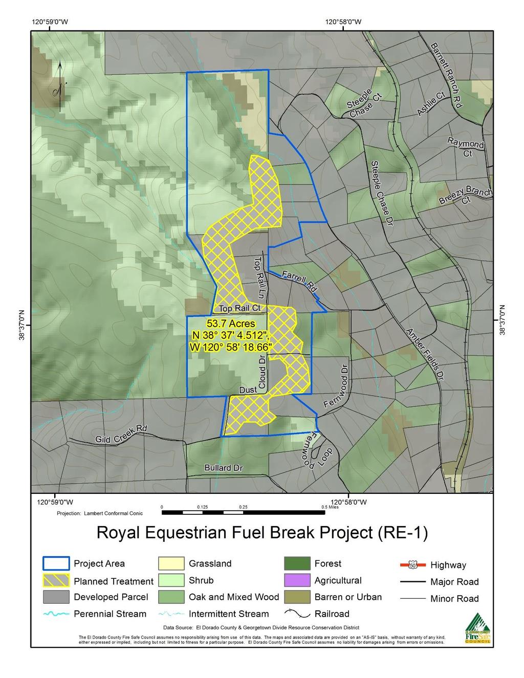
5 pg. 219
6 B. REE Community Recreation Trail and Railroad right of way The Royal Equestrian Estates HOA has a developed equestrian trail system that follows along much of the outside boundary of the REE. The trail is well defined along the northern, eastern and southern boundary of the community. This trail system if maintained to a width of 10 to 20 feet would provide a very good fuel break in the grass woodland portion of the estates. Through annually maintaining a trail tread to mineral soil of 6 to 10 feet wide with the grass and brush mowed to 10 feet wide on each side of the tread, the trail could provide an opportunity for suppression forces to use the trail as a control line during a wildfire. It is recommended that this trail system be accurately mapped so that local suppression forces would know that it exists and place it into their pre-attack planning. Once the trail has been constructed to the specifications and maintained annually it could be part of a fuel break system protecting the community from a wildfire threatening the community from the north, east and south. Also along the eastern boundary of the REE HOA is a railroad right-of-way which could be incorporated into a fuel reduction zone along with the equestrian trail. The vegetation, primarily grass and small brush, on either side of the rails could be mowed or cut 10 feet on each side of the rails. This could be done in concert with the right-of- way owner of the rails a joint powers authority. If the rails are put into service or maintained as a recreational trail again the owner of the right-of-way would have the responsibility for the treatment to prevent fires caused by the right-of-way use. Provide roadside hazard reduction along key ingress and egress routes inside the REE. The REE Fire Safe Council (FSC) has successfully mobilized property owners to provide proper defensible space alongside critical roads on their properties. They should continue to maintain this. If voluntary efforts are not successful, then contracted services can accomplish this at an estimated cost for roadside hazard reduction is $2000/acre. Clear Vacant Lots / Improve Defensible Space To both assist vacant lot owners and developed property owners in improving fire safety, there are several projects that can be undertaken including: Chipping /mulching program. The REE FSC has successfully sponsored annual community Chipper Days over the past 10 years to assist and encourage lot owners in the community to meet the State and County standards for fuels treatment by vegetation reduction efforts and using CalFire grant funded programs to have free chipping services chip the material on site. These programs should be continued. Vacant lots there remain several vacant lots that have not been treated. This is now the most significant internal fire risk for REE. The REEFSC reports that many attempts have been made over the years to encourage the owners of these lots to provide some treatment with only limited success. REE HOA may wish to consider implementing rules or CC&Rs similar to those adopted by many other local jurisdictions that require vacant lot owners to provide some defined level of treatment. The Royal Equestrian Estates Homeowners Association will work with the El Dorado County Fire Safe Council to establish several chipping days where the chipper will be exclusively available for the residents. A program to help economic disadvantaged or persons with physical limitations has pg. 220
7 been developed by the El Dorado County Fire Safe Council and can be used by homeowners unable financially or physically to clear their property. The intent is for this to supplement the El Dorado County Fire Safe council chipping program. Estimated cost for five chipping days is $3,800. Seek funding to strengthen the Defensible Space Program. The REE HOA may seek $6,000 to enhance the Defensible Space Program which includes the inspection for compliance with California s Defensible Space Program. Various sub-projects will be considered to enable the program to improve the defensible space situation within the subdivision; for example, the establishment of advisors and assistance to the remote owners of vacant lots to treat their properties. Implement a volunteer defensible space program of inspections and education a. If the volunteer inspection program is not sufficiently effective and material fire risks remain threatening the community, consider an abatement CC&R change that would involve contract clearing and billing the lot owner. This type of program has been successfully implemented in other communities and homeowner s associations. Explore funding to increase the number of Fire Hydrants / Maintain them a. Explore Cost / Benefit of installing additional Fire Hydrants REE was developed in two phases and the first phase which comprises about half of the REE HOA Properties does not have any fire hydrants. The second phase does have fire hydrants. The REE FSC has met with EID to develop rough costs of EID constructing sufficient pipeline capacity to the REE development and found it to be cost prohibitive at this time. And this did not include the very significant additional costs to dig up and install the pipes and hydrants in REE roads as well as to install a pumping station. However, as adjacent areas are developed REE will remain vigilant to see if there are potential future synergies available as other water infrastructure is installed to potentially cost effectively bring water supply to REE. At present the lack of fire hydrants is recognized by the El Dorado County Fire Protection District and a water tender is dispatched to all reported fires in REE. It has been recognized that the cost of installing Fire Hydrants is currently too high to really benefit the community and that the use of water tenders is a good trade off and beneficial to the community. b. Maintain Fire Hydrants- The property owner s water supply is provided by individual wells. The fire hydrant system and water to the hydrants is supplied by the Eldorado Irrigation District and is critical to effective community interior and exterior fire defenses. The Homeowners Association has a vested interest in their community water delivery system and has established a program of volunteers that, i. Tests each fire hydrant annually ii. Checks the water level and operational status of their 66,000-gallon water storage tank quarterly. iii. Drains and has the water tank inspected inside and out every five years with re-lining and any other needed maintenance accomplished as needed. pg. 221
8 This program should be continued. It may also be helpful for the REE FSC to contact the El Dorado Irrigation District and Eldorado County Fire Protection District to see if there are any further actions or programs that could be implemented to ensure that these systems are fully operational and well maintained and/or if these programs should be directed by the Fire District. pg. 222
9 Summary of proposed treatment by cost for the Royal Equestrian Area. COMMUNITY Royal Equestrian Royal Equestrian Royal Equestrian PRIORITY PROJECT NUMBER PROJECT DESCRIPTION 1 REE-1 West Side Fuel Break 2 REE-2 Riding Trail Fuel Reduction TREATMENT TYPE Fuel Reduction Fuel Reduction ACRES MILES ESTIMATED COST 54 $98, $40,000 Total Royal Equestrian $138,243 pg. 223
10 pg. 224
FIREWISE PLAN For. Southview Trails Community Association
 FIREWISE PLAN 2010 For Southview Trails Community Association Preface The Firewise Committee of the Southview Trails Community Association (STCA) submits this Firewise Plan 2010 along with the Firewise
Dear Interested Party;
 United States Department of Agriculture Forest Service Caribou-Targhee National Forest Curlew National Grassland Westside Ranger District 4350 Cliffs Drive Pocatello, ID 83204 (208) 236-7500 File Code:
The process for assessing your subdivision or neighborhood can be divided into five
 WILDFIRE HAZARD & RISK ASSESSMENT The process for assessing your subdivision or neighborhood can be divided into five distinct steps. Each is necessary to efficiently and accurately perform the assessment.
DOUGLAS COUNTY ZONING RESOLUTION Section 17 Wildfire Hazard - Overlay District 3/10/99. -Section Contents-
 SECTION 17 WILDFIRE HAZARD - OVERLAY DISTRICT -Section Contents- 1701 Intent... 17-2 1702 Definitions... 17-2 1703 Applicability... 17-5 1704 Wildfire Hazard Overlay District Map... 17-6 1705 Wildfire
GRIZZLY FLATS COMMUNITY WILDFIRE PROTECTION PLAN. REVIEW and UPDATE MARCH 2012
 GRIZZLY FLATS COMMUNITY WILDFIRE PROTECTION PLAN REVIEW and UPDATE MARCH 2012 Prepared by: Grizzly Flats Fire Safe Council Signature Page The agencies listed below have reviewed this 2012 Review and Update
FRENCH GULCH (UPPER CLEAR CREEK) PLANNING AREA
 PLANNING AREA") 2016 SHASTA COUNTY COMMUNITY WILDFIRE PROTECTION PLAN FRENCH GULCH (UPPER CLEAR CREEK) PLANNING AREA Covering the community of: French Gulch FRENCH GULCH (UPPER CLEAR CREEK) PLANNING AREA (2016) I. PROPOSED
2016 SHASTA COUNTY COMMUNITY WILDFIRE PROTECTION PLAN FRENCH GULCH (UPPER CLEAR CREEK) PLANNING AREA Covering the community of: French Gulch FRENCH GULCH (UPPER CLEAR CREEK) PLANNING AREA (2016) I. PROPOSED
Re: Initial Comments on the Mount Laguna and Pine Valley Community Defense and Healthy Forest Restoration Project
 Marian Kadota Adaptive Management Services Enterprise Team U.S. Forest Service 1072 Casitas Pass Road #288 Carpinteria, CA 93013 mkadota@fs.fed.us Re: Initial Comments on the Mount Laguna and Pine Valley
Community Wildfire Hazard Risk Assessment Sun Country Cle Elum, WA
 Community Wildfire Hazard Risk Assessment Cle Elum, WA Prepared by Suzanne Wade, FIREWISE Coordinator Kittitas County Conservation District Firewise Communities/USA Recognition Program Page 1 of 12 Table
Forest Restoration and Fire Prevention in the Lake Tahoe Basin
 Forest Restoration and Fire Prevention in the Lake Tahoe Basin Legislative Committee for the Review and Oversight of the Tahoe Regional Planning Agency (TRPA) and the Marlette Lake Water System January
Position Paper on the Nevada County Fire Plan
 228 Commercial Street #277, Nevada City, CA 95959 http://www.fona-nevco.org Position Paper on the Nevada County Fire Plan Presented by the Federation of Neighborhood Associations Revised April 2006 Summary
Hills Above Possum Kingdom Lake Firewise USA Risk Assessment
 Hills Above Possum Kingdom Lake Firewise USA Risk Assessment 2018 Introduction The Hills Above Possum Kingdom Lake (HAPKL) community in Graford, Texas boasts rolling hills, huge live oaks, dramatic elevation
RIM FIRE Preliminary Fuel Treatment Effectiveness Report
 RIM FIRE Preliminary Fuel Treatment Effectiveness Report USDA Forest Service, Pacific Southwest Region, Stanislaus National Forest DOI National Park Service, Pacific West Region, Yosemite National Park
2016 Yosemite West Hazardous Fuel Reduction Project
 Free Help to Protect Your Property The California Department of Forestry and Fire Protection (CAL FIRE) has awarded nearly $100,000 from its 2015-2016 State Responsibility Area Fire Prevention Fund (SRAFPF)
WILLOW BASIN WILDLAND URBAN INTERFACE FUELS TREATMENT PROJECT Manti-La Sal National Forest Moab Ranger District
 WILLOW BASIN WILDLAND URBAN INTERFACE FUELS TREATMENT PROJECT Manti-La Sal National Forest Moab Ranger District Proposed Actions: The Moab/Monticello Ranger District on the Manti-La Sal National Forest
2017 Grants Clearinghouse Competitive Grants Program Report
 2017 Grants Clearinghouse Competitive Grants Program Report August 28, 2017 2017 Highlights 21 PROJECTS AWARDED 15 COUNTIES 27,558 ACRES GRANT AWARDS PROVIDED: $2,100,000 California Fire Safe Council (CFSC)
Executive Summary. San Marcos Pass - Eastern Goleta Valley Mountainous Communities Community Wildfire Protection Plan
 Executive Summary San Marcos Pass - Eastern Goleta Valley Mountainous Communities Community Wildfire Protection Plan The San Marcos Pass and Eastern Goleta Valley (SMP/EGV) Mountainous Communities Community
A Community Wildfire Protection Plan
 A Community Wildfire Protection Plan The Circle Oaks Homes Association Original: 05/01/2009 Updated: 01/02/2013 Prepared by: Stephen Gort Manager, Circle Oaks Homes Association Page 1 of 12 Original: 05/01/2009
INTRODUCTION DEFINITION OF THE HOME IGNITION ZONE
 FIREWISE COMMUNITIES/USA RECOGNITION PROGRAM COMMUNITY ASSESSMENT May, 2011 Strawberry Lane Meadows Ashland, Oregon INTRODUCTION The Firewise Communities/USA program is designed to provide an effective
Lutsel K e. Community Wildfire Protection Plan
 Lutsel K e Community Wildfire Protection Plan Prepared for: Government of the Northwest Territories Environment and Natural Resources - Forest Management Division March 2012 Stew Walkinshaw, R.P.F. Canmore,
WILDLAND FIRE OVERVIEW
 WILDLAND FIRE OVERVIEW for DeNovo Independence Property Blaine County, Idaho Prepared by: Blackbull Wildfire Services, LLC Dick Mangan, President Missoula, Montana 59804 USA August 2009 EXECUTIVE SUMMARY
A COMMUNITY WILDFIRE PROTECTION PLAN
 A COMMUNITY WILDFIRE PROTECTION PLAN DEVELOPED BY THE LAKE ALMANOR COUNTRY CLUB FIREWISE COMMITTEE WITH SUPPORT FROM THE PLUMAS COUNTY FIRE SAFE COUNCIL AND THE PLUMAS COUNTY OFFICE OF EMERGENCY SERVICES
3.12 PUBLIC SAFETY AND HAZARDOUS MATERIALS
 3.12 PUBLIC SAFETY AND HAZARDOUS MATERIALS This section evaluates the potential impacts of the proposed project on public safety and hazardous materials. The public safety concerns related to the project
Firewise Communities:
 Firewise Communities: Where We Live. How We Live. An introduction to Firewise concepts for local communities Agenda National Firewise Communities Program Understanding Wildfire How Homes Ignite Hazard
Hamlet of Tulita. Community Wildfire Protection Plan
 Hamlet of Tulita Community Wildfire Protection Plan Prepared for: Government of the Northwest Territories Environment and Natural Resources - Forest Management Division March 2011 Stew Walkinshaw, R.P.F.
APPENDIX 5: PIONEER/VOLCANO PLAN- NING UNIT COMMUNITY FEATURES
 APPENDIX 5: PIONEER/VOLCANO PLAN- NING UNIT COMMUNITY FEATURES CONTENTS Pioneer/Volcano Community Features... 102 5.1. Social and Political Setting... 102 5.1.1. Cultural Resources... 102 5.1.2. Population
Land Use Planning to Reduce Wildfire Risk: Lessons from Five Western Cities
 Land Use Planning to Reduce Wildfire Risk: Lessons from Five Western Cities Land Use Planning Strategies to Reduce Wildfire Risk Community Initiatives Voluntary Property Assessment Partnerships and Coalitions
EDCFSC. El Dorado County Fire District CWPP Final 8/10/11 El Dorado County Fire Safe Council Page 1
 8/10/11 El Dorado County Fire Safe Council Page 1 Community Wildfire Protection Plan Mutual Agreement Page The Community Wildfire Protection Plan (CWPP) was developed for central El Dorado County and the
A Comprehensive Approach to Urban. Photo: Chris Doolittle
 A Comprehensive Approach to Urban Wildfire Losses in California Jon E. Keeley 1,2, Alexandra D. Syphard 3, Teresa Brennan 1, C.J. Fotheringham 1 1 U.S.. Geological Survey, Sequoia National Park, CA 2 University
Fire Danger Rating Areas
 Fire Danger Rating Areas Timber West This area is the Douglas-fir/Ponderosa Pine forest of the CAL FIRE Direct Protection Area in Trinity County. It is in the Interior Conifer Q81 st Planning Belt. The
Cypress Fire Protection District Fire Defense Plan
 Cypress Fire Protection District Fire Defense Plan Adopted: September 2017 Revision March 2018 Mission statement: The purpose of the Cypress Fire Protection Districts Fire Defense Plan is to provide a
Fire Adapted Communities on the Plains. Master Volunteer Forest Steward Course Lisa Mason, Colorado State Forest Service April 22, 2014
 Fire Adapted Communities on the Plains Master Volunteer Forest Steward Course Lisa Mason, Colorado State Forest Service April 22, 2014 About the CSFS The mission of the CSFS is to achieve stewardship of
Riparian Vegetation Protections. Heritage Tree Protection
 PLACER Protections in place: Oak Tree Retention/ Replacement Requirements General Plan Language Specific Voluntary Rural Design require preservation of native trees and groves through replacement and dedication
County of El Dorado. Tree Mortality Hazard Tree Removal Plan
 County of El Dorado Tree Mortality Hazard Tree Removal Plan The County of El Dorado Board of Supervisors proclaimed a Local State of Emergency due to drought conditions on October 21, 2014, and has renewed
El Dorado County COMMUNITY WILDFIRE PROTECTION PLAN Community Tab for LOGTOWN FIRE SAFE COUNCIL ACTIVITIES
 El Dorado County COMMUNITY WILDFIRE PROTECTION PLAN Community Tab for LOGTOWN FIRE SAFE COUNCIL ACTIVITIES Prepared for Inclusion in the: EL DORADO COUNTY FIRE SAFE COUNCIL Community Wildfire Protection
DEFENSIBLE. Landscaping
 DEFENSIBLE Landscaping Create defensible space for fire safety Every year, wildfires have burned hundreds of thousands of acres in the United States, forced evacuations, burned structures, and claimed
Mike Merz Pres., BHNA
 Wildfire Mitigation Projects Our neighbors are ecstatic about the free chipper! As one person said, this is the best thing the City has ever done for us. We have removed a lot of flammable brush & trees
4.7 HAZARDS AND HAZARDOUS MATERIALS
 4.7 HAZARDS AND HAZARDOUS MATERIALS This section describes the environmental setting (existing conditions and regulatory setting) for hazards and hazardous materials relating to the proposed project, as
Wildfire in South Carolina
 Wildfire in South Carolina Average number of wildfires per year 3,000 Average acres per year 20,000 Average acres per fire 6.7 Wildfires happen almost every day across SC! January 29 Fire Activity A Landscape
IV. ENVIRONMENTAL IMPACT ANALYSIS H. HAZARDS AND HAZARDOUS MATERIALS
 IV. ENVIRONMENTAL IMPACT ANALYSIS H. HAZARDS AND HAZARDOUS MATERIALS INTRODUCTION This section of the DEIR evaluates potential hazards and hazardous materials that may result from implementation of the
Salmon River Fire Safe Council Butler Cooperative Fire Safe Plan 2002 Draft 6/24/02 Butler Creek Cooperative Fire Safe Plan
 Butler Creek Cooperative Fire Safe Plan Background Salmon River Subbasin Fire History The entire Salmon River watershed is at risk of catastrophic fire. The United States Congress passed the Weeks Act
Reading Project Noxious Weed Risk Assessment Hat Creek Ranger District Lassen National Forest April 3, 2013
 Reading Project Noxious Weed Risk Assessment Hat Creek Ranger District Lassen National Forest April 3, 2013 Prepared By: /s/ Tim Kellison Date: 05-31-2013 Tim Kellison Assistant Forest Botanist Reviewed
OBSTACLES AND SOLUTIONS
 OBSTACLES AND SOLUTIONS The Douglas County CWPP Core Team identified six common obstacles that communities and stakeholders throughout Douglas County face in working to become safer from wildfire. These
APPENDIX D: WILDFIRE ASSESSMENT
 APPENDIX D: WILDFIRE ASSESSMENT Community Wildfire Hazard Assessment Report Montgomery County, Kansas Jason Hartman, Fire Prevention Specialist Kansas Forest Service June 20, 2008 Objective To provide
El Dorado County COMMUNITY WILDFIRE PROTECTION PLAN Sub-Section for POLLOCK PINES FIRE SAFE COUNCIL ACTIVITIES
 El Dorado County COMMUNITY WILDFIRE PROTECTION PLAN Sub-Section for POLLOCK PINES FIRE SAFE COUNCIL ACTIVITIES Prepared for Inclusion in the: EL DORADO COUNTY FIRE SAFE COUNCIL Community Wildfire Protection
Statement for the Record. Forest Service. United States Department of Agriculture. For the United States House of Representatives
 Statement for the Record Forest Service United States Department of Agriculture For the United States House of Representatives Committee on Natural Resources Subcommittee on Public Lands and Environmental
LOS ALTOS HILLS COUNTY FIRE DISTRICT
 ANNEX 4. LOS ALTOS HILLS COUNTY FIRE DISTRICT The Los Altos Hills County Fire Protection District (LAHCFD), a Board of Supervisors governed special district, provides fire protection to the Town of Los
LAKEHEAD PLANNING AREA
 2016 SHASTA COUNTY COMMUNITY WILDFIRE PROTECTION PLAN LAKEHEAD PLANNING AREA Picture courtesy of Lee Delaney Covering the communities of: Delta Gibson Gilman Road Gregory Creek land Lakes Lakehead Lakeshore
Mt. Elizabeth Drive Fuel Reduction Project (30422) Decision Memo
 Decision Memo") Mt. Elizabeth Drive Fuel Reduction Project (30422) Decision Memo Stanislaus National Forest Mi-Wok Ranger District Tuolumne County, California This decision memo provides documentation, pursuant to the
Mt. Elizabeth Drive Fuel Reduction Project (30422) Decision Memo Stanislaus National Forest Mi-Wok Ranger District Tuolumne County, California This decision memo provides documentation, pursuant to the
Integrating Wildfire Management with Conservation Objectives. Richard Harris, Ph.D., RPF #1961
 Integrating Wildfire Management with Conservation Objectives Richard Harris, Ph.D., RPF #1961 rrharrisconsulting@gmail.com Projects Objectives and Application Provide compendium of practices to balance
B. Wildfire Mitigation
 B. Wildfire Mitigation Addendum Part B supplements the information in Parts I through VIII of the HMA Unified Guidance. Addendum Part B is applicable to HMGP and the PDM Program and supersedes FEMA Mitigation
EXISTING EID WATER SUPPLY SOURCES
 EXISTING EID WATER SUPPLY SOURCES FOLSOM RESERVOIR Folsom Reservoir is located at the west end of El Dorado County, at the confluence of the North and South Forks of the American River. EID treats water
Hamlet of Fort Resolution. Community Wildfire Protection Plan
 Hamlet of Fort Resolution Community Wildfire Protection Plan Prepared for: Government of the Northwest Territories Environment and Natural Resources - Forest Management Division March 2011 Stew Walkinshaw,
Chapter 13: Wildlife and Vegetation
 Chapter 13: Wildlife and Vegetation Introduction and Setting Nevada County contains an extremely wide range of plants, animals and habitat types. With topographic elevations ranging from 300 feet in the
The following County planning and policy documents relate to or implement the Circulation, Infrastructure, and Services Element.
 Mariposa General Plan 9 CIRCULATION, INFRASTRUCTURE, AND SERVICES T his element identifies circulation and infrastructure needs in the County. The Element provides guidance for transportation and capital
Characterizing the Fire Threat to Wildland Urban Interface Areas in California
 Introduction Characterizing the Fire Threat to Wildland Urban Interface Areas in California This document outlines the procedures used to identify areas in California that pose significant threats from
Agenda Item #4 Attachment C Page 1 of 6
 PLAN OF SERVICE LA CANADA SUBDIVION ANNEXATION TO THE EL DORADO IRRIGATION DISTRICT, Page 1 of 6 LAFCO PROJECT N 2010-02> Z08-0001/ PD08-0003/ TM08-1463 EI Dorado County Project Name: Project Assessor
Acres within Planning Area. Total Acres Burned
 Calf-Copeland Project Description Figure 1: Dead sugar pine in the Calf-Copeland planning area. Sugar pine grow best in open conditions. In the absence of fire disturbance, high densities of Douglas-fir
S.1.1 Objective Airport Design Ensure all airports are designed in compliance with adopted federal and state safety standards
 Goals, Objectives, and S.1 Airport Safety Goal Increase airport safety in and around airport facilities. S.1.1 Objective Airport Design Ensure all airports are designed in compliance with adopted federal
Regulation II Rule 201 Prohibitions, General Requirements and Burn Day Determinations
 Regulation II Rule 201 Prohibitions, General Requirements and Burn Day Determinations This Rule replaced Rule 201 General Prohibitions and Exemptions for Selected Open Burning. The current version was
INTRODUCTION DEFINITION OF THE HOME IGNITION ZONE
 FIREWISE COMMUNITIES/USA RECOGNITION PROGRAM COMMUNITY ASSESSMENT Oak Knoll Meadows Ashland, Oregon INTRODUCTION The Firewise Communities/USA program is designed to provide an effective management approach
2.1 NEIGHBORHOOD BOUNDARY DELINEATION
 2.0 METHODOLOGY 2.1 NEIGHBORHOOD BOUNDARY DELINEATION The wildland-urban interface is the place where homes and wildland meet. This project focused on identifying hazards and risks in the wildland-urban
PRESCRIBED FIRE IN SOUTHWEST IDAHO
 2016 PRESCRIBED FIRE IN SOUTHWEST IDAHO In southwest Idaho, public land managers work to: address public health and safety concerns; treat insect and disease infestations; reduce the risk of severe wildfires
INTRODUCTION DEFINITION OF THE HOME IGNITION ZONE
 FIREWISE COMMUNITIES/USA RECOGNITION PROGRAM COMMUNITY ASSESSMENT Lincoln Neighborhood (Merrill Circle, Roca Canyon, Quailhaven) Ashland, Oregon INTRODUCTION The Firewise Communities/USA program is designed
FIREWISE USA RECOGNITION PROGRAM COMMUNITY WILDFIRE RISK ASSESSMENT
 FIREWISE USA RECOGNITION PROGRAM COMMUNITY WILDFIRE RISK ASSESSMENT This information is intended to help guide you and your community through the risk assessment process. Each state has the ability to
Statement of. Dale Bosworth, Chief U.S. Forest Service United States Department of Agriculture
 Statement of Dale Bosworth, Chief U.S. Forest Service United States Department of Agriculture Before the House Resource Committee Subcommittee on Forests and Forest Health U.S. House of Representatives
5.1 SUMMARY OF PROJECT FACILITIES AND SERVICES
 5.1 SUMMARY OF PROJECT FACILITIES AND SERVICES This Chapter describes the water, waste water, storm water facilities, electric, gas, and communications facilities, police and fire services, and school
Summary: Wildland Fire Research February 2013
 Summary: Wildland Fire Research February 2013 THE PROBLEM: The price of fighting forest fires has been increasing substantially. At the national level, fire costs represent nearly half of the U.S. Forest
ESCONDIDO FIRE DEPT TRAINING MANUAL Section Engine Module Page 1 of 6 Wildland Hand Crews Revised
 Engine Module Page 1 of 6 HANDCREW OPERATIONS Hand crews play an important role in wildland fire suppression. Each crew is made up of highly skilled individuals using a variety of hand tools that match
Placerville, a Unique Historical Past Forging into a Golden Future
 Placerville, a Unique Historical Past Forging into a Golden Future City Manager s Report October 10, 2017 City Council Meeting Prepared by: Steve Youel, Director of Community Services Item #: Subject:
INTRODUCTION DEFINITION OF THE HOME IGNITION ZONE
 FIREWISE COMMUNITIES/USA RECOGNITION PROGRAM COMMUNITY ASSESSMENT Lithia Creek Estates Ashland, Oregon INTRODUCTION The Firewise Communities/USA program is designed to provide an effective management approach
FIREWISE USA RECOGNITION PROGRAM COMMUNITY WILDFIRE RISK ASSESSMENT
 FIREWISE USA RECOGNITION PROGRAM COMMUNITY WILDFIRE RISK ASSESSMENT This template will help guide your community through the Firewise USA risk assessment process. The assessment should be completed in
MUNICIPALITY OF ANCHORAGE
 MUNICIPALITY OF ANCHORAGE ANCHORAGE PARKS & RECREATION Memorandum PRC 08-31 DATE: 8 May, 2008 TO: FROM: SUBJECT: Parks & Recreation Commission Monique Anderson, Parks Superintendent PRC 08-31 Firewise
APPENDIX D: WILDFIRE ASSESSMENT
 APPENDIX D: WILDFIRE ASSESSMENT Community Wildfire Hazard Assessment Report Neosho County, Kansas Jason Hartman, Fire Prevention Specialist Kansas Forest Service April 7, 2008 Objective To provide base
Laramie County CWPP DRAFT REVIEW
 Laramie County CWPP DRAFT REVIEW Where Are We What Do We Need to Do Draft Review Completed and Forwarded Review Content and Take Input From Public and Joint Wildfire Task Force Make Revisions as Agreed
MEMORANDUM. Governor John Hickenlooper & Members of the Colorado General Assembly
 690 Kipling Street, Suite 3000 Lakewood, CO 80215 MEMORANDUM TO: FROM: Governor John Hickenlooper & Members of the Colorado General Assembly Paul L. Cooke, Director (Outgoing) DATE: April 25, 2016 RE:
CalFire s Vegetation Management Program: A Field-Based Training Summary, Reflections, and Next Steps First Stop: Trabing Fire Area
 CalFire s Vegetation Management Program: A Field-Based Training Summary, Reflections, and Next Steps First Stop: Trabing Fire Area On Friday February 27 th, a group of forest and fire agency personnel,
FS-PG PERIMETER GUARD
 WILD FIRE RETARDANT POWDER FS-PG PERIMETER GUARD HANDBOOK Passive Fire Protection designed to create a long-term fire break around your property. Protect your home and property from wildfire events. www.flameseal.com
Wekweeti Community Wildfire Protection Plan
 Wekweeti Community Wildfire Protection Plan Prepared for: Government of the Northwest Territories Environment and Natural Resources - Forest Management Division With federal support through Natural Resources
EL DORADO COUNTY GENERAL PLAN PUBLIC SERVICES AND UTILITIES ELEMENT PRINCIPLE INTRODUCTION RELATIONSHIP TO OTHER ELEMENTS
 EL DORADO COUNTY GENERAL PLAN PUBLIC SERVICES AND UTILITIES ELEMENT PRINCIPLE The Plan must identify the types of governmental services which are necessary to meet residents needs and provide a fiscally
WILDLAND URBAN INTERFACE (WUI) PRODUCTS
 PRODUCTS") CALIFORNIA DEPARTMENT of FORESTRY and FIRE PROTECTION OFFICE OF THE STATE FIRE MARSHAL WILDLAND URBAN INTERFACE (WUI) PRODUCTS Published by CAL-FIRE WILDLAND FIRE PREVENTION ENGINEERING Revised 12/17/07
CALIFORNIA DEPARTMENT of FORESTRY and FIRE PROTECTION OFFICE OF THE STATE FIRE MARSHAL WILDLAND URBAN INTERFACE (WUI) PRODUCTS Published by CAL-FIRE WILDLAND FIRE PREVENTION ENGINEERING Revised 12/17/07
LETTER 174: EL DORADO HILLS AREA PLANNING ADVISORY COMMITTEE
 LETTER 174: EL DORADO HILLS AREA PLANNING ADVISORY COMMITTEE Response to Comment 174-1 (GP): The role of APAC and its vision for El Dorado Hills is acknowledged. Response to Comment 174-2 (GP): Please
1. FALLEN LEAF FIRE DEPARTMENT
 1. FALLEN LEAF FIRE DEPARTMENT 1.1 Demographics, location, topography, and climatic data The Fallen Leaf Fire Department (FLFD) is located in the southwestern portion of the Lake Tahoe Basin (figure 5).
Santa Clara County Community Wildfire Protection Plan Annex 1. Santa Clara County Central Fire Protection District Chapter 5
 ANNEX 1 CHAPTER 5 NEW ALMADEN The Village of New Almaden is nestled in a canyon 11 miles south of San Jose between the Pueblo Hills and the spurs of the Santa Cruz Mountains. New Almaden is the site of
Feather Falls: Wildfire Community Assessment and Action Plan. Feather Falls. Wildfire Community Assessment & Action Plan
 Feather Falls Wildfire Community Assessment & Action Plan November 17, 2015 1 INDEX I. Introduction 3 a. Feather Falls Community At-a-Glance Demographics b. Collaborators who assisted with assessment Section
Wildlife Conservation Society Climate Adaptation Fund 2014 Restoring Oak Resilience at the Table Rocks, Rogue River Basin, Oregon FACT SHEET
 Wildlife Conservation Society Climate Adaptation Fund 2014 Restoring Oak Resilience at the Table Rocks, Rogue River Basin, Oregon FACT SHEET Project Overview Oak ecosystems in the Pacific Northwest exist
POLICY and PROCEDURE FIRE SAFETY
 FIRE SAFETY P & P # 12 1 of 3 04/18/2018 06/24/2005 PURPOSE To establish policy procedures for fire safety to comply with Pinebrook CC&R s, Ebbetts Pass Fire District (EPFD) Ordinances California Department
NDSU - North Dakota Forest Service North Dakota Cooperative Fire Protection Initiative Budget Request
 Agency Information NDSU - North Dakota Forest Service North Dakota Cooperative Fire Protection Initiative 2015-17 Budget Request North Dakota State Board of Higher Education May 29, 2014 NDSU-North Dakota
9.0 KINGS CANYON LOWER
 9.0 KINGS CANYON LOWER FUEL HAZARD: MODERATE COMMUNITY RISK: LOW The Lower Kings Canyon neighborhood contains the Kings Canyon Highlands and Kings Canyon Meadows subdivisions to the west of Longview Way:
ORGANIZATION AND JURISDICTION
 ANNEX 7. CITY OF CUPERTINO Cupertino is a city on the western edge of the Santa Clara Valley and extending into the foothills of the Santa Cruz Mountains. According to the 2010 Census the population was
Fuel Reduction Projects
 Fuel Reduction Projects February 2012 1 Collaboration Group Charter Issues The Kern River Valley and Kern Plateau areas (areas) in Tulare and Kern Counties have four government agencies and one non-government
EL DORADO COUNTY REGIONAL FIRE PROTECTION STANDARD
 EL DORADO COUNTY REGIONAL FIRE PROTECTION STANDARD Fire Water Supply without a Purveyor Residential & Commercial STANDARD #D-003 EFFECTIVE 01-04-2016 1. PURPOSE 1.1. The California Fire Code (CFC) requires
Building a Resilient Community in the Shadow of a Catastrophic Fire
 Building a Resilient Community in the Shadow of a Catastrophic Fire Stephanie Larson, PhD Livestock & Range Management Advisor Steven Swain Environmental Horticulture Advisor UCCE Sonoma & Marin Counties
Agenda Item #5 Attachment A Appendix B Page 1 of 7
 Page 1 of 7 The California Department of Forestry and Fire Protection (CAL FIRE) Although the California Department of Forestry and Fire Protection (CAL FIRE, formerly known as CDF) is not a local entity,
HAZARD DESCRIPTION... 1 LOCATION AND HISTORICAL...
 W I L D F I R E HAZARD DESCRIPTION... 1 LOCATION AND HISTORICAL... 1 SIGNIFICANT PAST EVENTS... 1 EXTENT... 2 PREVIOUS OCCURRENCES... 6 PROBABILITY OF FUTURE EVENTS... 7 VULNERABILITY AND IMPACT... 7 HAZARD
Appendix A: Vegetation Treatments
 Appendix A: Vegetation Treatments In general, the proposed actions for the Light Restoration project focuses on establishing the composition, structure, pattern, and ecological processes necessary to make
The Galton Project Kootenai National Forest. The Galton Project
 Introduction The Galton Project The Fortine Ranger District of the Kootenai National Forest is in the early stages of developing a project entitled Galton, named for the mountain range dominating the eastern
Sequoia National Forest, California; Summit Fuels Reduction and Forest Health. Notice of intent to prepare an environmental impact statement.
 This document is scheduled to be published in the Federal Register on 09/16/2015 and available online at http://federalregister.gov/a/2015-23236, and on FDsys.gov [3410-11-P] DEPARTMENT OF AGRICULTURE
Silver City Case Study (text only) Community Responses to Wildland Fire Threats in New Mexico
 Community Responses to Wildland Fire Threats in New Mexico") Overview Silver City, located in Grant County, lies in southwestern New Mexico at the base of the Pinos Altos Mountains. The city borders the southern edge of Gila National Forest and is a short distance
Overview Silver City, located in Grant County, lies in southwestern New Mexico at the base of the Pinos Altos Mountains. The city borders the southern edge of Gila National Forest and is a short distance
Volcanoville Community Wildfire Protection Plan
 Volcanoville Community Wildfire Protection Plan Review and Update of the Volcanoville Community Fire Safe and Fuels Reduction Plan, June 00 September 01 Volcanoville CWPP 01 Final Page 1 1 1 1 1 1 1 1
To Have Healthy Watersheds, We Need Healthy Forests. Steve Brink Vice President Public Resources California Forestry Association
 To Have Healthy Watersheds, We Need Healthy Forests Steve Brink Vice President Public Resources California Forestry Association National Forests Managed by the Forest Service in California Sacramento Stockton