A Crown Cover Chart For Oak Savannas
|
|
|
- Posy Patrick
- 6 years ago
- Views:
Transcription

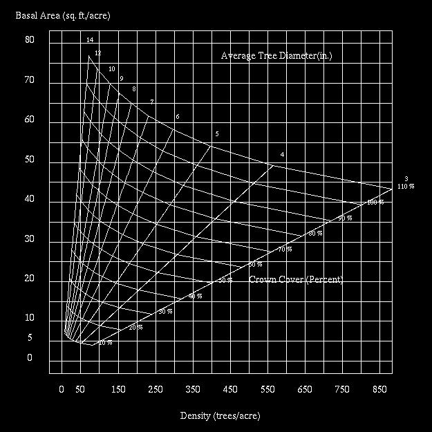
1 March, 1994, TB-NC-2 A Crown Cover Chart For Oak Savannas Jay R. Law, USDA Forest Service (retired) Paul S. Johnson, Principal Silviculturist Garry Houf, Forest Biologist, Mark Twain National Forest Although oak savannas have been defined in many ways, they are characterized by scattered trees, largely comprised of oaks, and a sparse ground layer rich in grasses and forbs (Haney and Apfelbaum 1990). Nuzzo (1986, p. 11) more specifically defined oak savannas as plant communities "...dominated by oaks having between 10 and 80 percent canopy, with or without a shrub layer, and herbaceous cover, predominately a grassy layer, composed of both prairie and forest communities..." From these definitions, it is apparent that a certain range in crown coverage of trees is a characteristic of oak savannas central to their definition and thus their preservation, restoration, and management. This paper presents a crown cover chart for estimating the crown coverage of open-grown oaks and hickories in oak savannas and similar plant communities. Application The crown cover chart (fig. 1) can be used to estimate the crown cover of trees as a percent of total area. Potential applications of the chart include monitoring changes in savanna crown cover, determining needed reductions in crown cover, and defining the savanna "state." In restoring savannas that have grown into closed canopy stands, you can use the chart to estimate initial crown cover before restoration work is begun and again after crown cover has been reduced. To use the chart, you need to estimate two stand parameters from sample plots within a savanna: (1) basal area in square feet per acre, and (2) number of trees per acre. Variation in tree size and spatial distribution determines how many sample points you must have to attain a given degree of accuracy in estimation. In most applications, at least 10 well-distributed sample points will be required to obtain acceptable estimates. To determine the average basal area in square feet per acre, use the point sampling method and an angle gauge or prism (Hays et al. 1981, Husch et al. 1982). This variable- radius plot
2 sampling method can be used to estimate average basal area per acre of trees above some minimum threshold diameter (e.g., 4 inches d.b.h.). In the Eastern United States, the 10- factor (English unit) prism has been widely used. If that prism or angle gauge is used, each tree counted at a sample point represents 10 square feet of basal area per acre. In addition to obtaining a tree count at each point-sample plot with a prism or angle gauge, you'll also need to obtain tree counts on fixed-radius plots. To do this, use 1/20-acre plots (26.4 feet in radius) centered on each point-sample plot. These tree counts then are used to estimate number of trees per acre. See table 1 for an example of how the chart can be applied. In this example, the number of trees sampled on 10 basal area factor-10 plots total 38 (24 post oaks, 4 white oaks, 4 black oaks, 4 hickories, and 2 other species 1). Because each tree represents 10 square feet of basal area and there are 10 sample points, the estimated basal area is 38 x 10/10 or 38 square feet per acre. The total tree count on the ten 1/20-acre fixed-radius plots (1/2-acre) is 24. Thus, the estimated number of trees per acre is 24/0.5 or Because "other" species were a minor component of this savanna, they were included in crown cover estimates even though the crown cover chart may not accurately estimate their crown areas. Table 1. --Inventory of trees on 10 point-sample plots and 10 fixed radius plots in a post oak (Quercus stellata Wangenh.) savannah restoration project, Mark Twain National Forest, Missouri. Post oak Point-sample tree count by species (10-factor prism) White oak Black oak Hickory Other Total 1/20- acre tree count With this information, you can estimate the average crown cover for the savanna from the crown cover chart (fig. 1). First, locate 48 trees per acre on the horizontal axis of the upper chart, which pertains to stands with trees that average 3 to 14 inches in diameter measured 4.5 feed above ground (d.b.h.). Then locate the corresponding basal area value by moving vertically along the basal area scale until a value of 38 is reached. Note that this intersection of basal area and trees per acre occurs between the 50- and 60-percent crown cover curves, which are shown as diagonal lines. By interpolation, crown cover in this case is thus approximately 55 percent.
3
 equation.")
4 Quercus alba L.), black oak (Q. velutina Lam.), northern red (Q. rubra L.), and shagbark hickory (Carya ovata (Mill.) K. Koch) (Krajicek et al. 1961). Because differences among species in crown diameter/d.b.h. relations were small, species were combined to produce a single maximum crown area (MCA) equation. The equation accounts for 97 percent of the variation in observed relative crown area and is given by: MCA = D D 2
5 where, MCA is percent of an acre and D is d.b.h. in inches (Krajicek et al. 1961). Equation 1 can thus be used to estimate the relative area of tree crowns (percent crown cover) in open-grown stands by summing the MCA's of all trees on an acre. Because of the high correlation between crown area and stem area at d.b.h., the resulting sums produce accurate estimates of relative crown cover when there is no overlap between crowns. Accordingly, the equation should be used only to estimate crown cover in stands where the sum of MCA's for all trees on an acre is 100 percent of less and trees are well dispersed. The equation is thus potentially applicable to estimating tree crown cover in oak savannas. In that context, crown cover is defined as the proportion of an acre (or other unit area) covered by the vertical projection of tree crowns onto an acre. The equation assumes that tree crowns are circular. We used the stocking chart format developed by Gingrich (1967) to graphically express crown cover in relation to other stand parameters. The method assumes that a given measure of relative stand density (or, in our case, relative crown cover) can be graphically expressed as a function of mean stand diameter, basal area per acre, and number of trees per acre. Expressing those relations in a chart requires that equation 1 be extended to the stand (population) level by the following relation: SCC = N Σ D Σ D 2 where SCC is stand crown cover as a percent of an acre, N is the number of trees per acre above a given minimum threshold diameter, Σ D is the sum of tree diameters at d.b.h., and Σ D 2 is the sum of the squared diameters. Solving equation 2 for N = 1 thus yields crown cover estimates identical to equation 1. The chart (fig. 1) and equation 2 produce comparable estimates of crown cover. Equation 2 produces more accurate estimates of crown cover because a given variance in tree diameters must be assumed to construct the chart; but in equation 2, this variance is inherent in the relation between Σ D and Σ D 2 for a given sample of diameters (Gingrich 1967). However, comparisons of estimates across the range of diameter distributions likely to occur in oak savannas revealed that the two methods of estimation will be within +5 percent more than 95 percent of the time. Literature Cited Gingrich, Samuel F Measuring and evaluating stocking and stand density in upland hardwood forests in the Central States. Forest Science. 13(1): Haney, Alan: Apfelbaum, Steven I Structure and dynamics of midwest oak savannas. In: Sweeney, James S., ed. Management of dynamic ecosystems, proceedings of the symposium; 1989 December 5; Springfield, IL. West Lafayette, IN: North Central Section, The Wildlife Society: Hays, Robert L.; Summers, Cliff; Seitz, William.
6 1981. Estimating wildlife habitat variables. Publ. FWS/OBS=81/47. Washington, DC: U.S. Department of the Interior, Fish and Wildlife Service Husch, Bertram; Miller Charles I.; Beers, Thomas W Forest mensuration. New York, NY: Wiley and Sons. 402 p. Krajicek, John E.; Brinkman, Kenneth A.; Gingrich, Samuel F Crown competition-a measure of density. Forest Science. 7(1): McGill, D.W.; Rogers, R.; Martin, A.J.; Johnson, P.S Measuring stocking in northern red oak stands in Wisconsin. Northern Journal of Applied Forestry. [In press]. Nuzzo, Victoria A Extent and status of midwest oak savanna: presettlement and Natural Areas Journal. 6(2):6-36. The United States Department of Agriculture (USDA) Forest Service is a diverse organization committed to equal opportunity in employment and program deliver. USDA prohibits discrimination on the basis of race, color, national origin, sex, religion, age, disability, political affiliation and familial status. Persons believing they have been discriminated against should contact the Secretary, U.S. Department of Agriculture, Washington, DC 20250, or call (voice), or (TDD). Copyright 1998, USDA Forest Service
Forest Resources of the Black Hills National Forest
 United States Department of Agriculture Forest Service Rocky Mountain Research Station August 22 Forest Resources of the Black Hills National Forest Larry T. DeBlander About the author Larry T. DeBlander
HARDWOOD NOTES. Wildlife Habitat Evaluation
 Wildlife Habitat Evaluation North Central Forest Experiment Station 9.02 HARDWOOD NOTES To evaluate wildlife habitat you need to answer the following questions related to the three basic habitat components-food,
Texas, Forest Inventory & Analysis Factsheet. James W. Bentley. Forested Area. Introduction. Inventory Volume
 Texas, 21 James W. Bentley Forest Inventory & Analysis Factsheet F I A The Nation s Forest Census Introduction Guadalupe River State Park, Comel County, TX. (photo by This science update summarizes the
WISCONSIN WOODLANDS:
 G3362 WISCONSIN WOODLANDS: Estimating Stocking Conditions In Your Timber Stand Jeff Martin Foresters use the term stocking to indicate the number of trees or basal area per acre in a timber stand an aggregation
Sampling Land Use Edge from ~ e6ai photographs
 United States Department of Agriculture Forest Service Northeastern Forest Experiment Station Research Note NE-321 Sampling Land Use Edge from ~ e6ai photographs - Line Transect vs. Circular Pattern Robert
NTRAL HARDWOOD NOTES. Thinning Even-Aged, Upland Oak Stands
 North Central Forest Experiment Station 6.06 NTRAL HARDWOOD NOTES Thinning Even-Aged, Upland Oak Stands Thinning produces bigger and better trees faster. Thinning removes poor quality trees and concentrates
Simulating Regeneration Dynamics in Upland Oak Stands
 Simulating Regeneration Dynamics in Upland Oak Stands Powered By Powered by: USDA Forest Service Southern Research Station Dr. David Loftis Powered By Powered by: Regen for Excel is a simulation model
STEM FORM CHANGES IN UPLAND OAKS AFTER THINNING
 STEM FORM CHANGES IN UPLAND OAKS AFTER THINNING by. Donald E, Hilt and Martin Em Dale FOREST SERVICE RESEARCH PAPER NE-433 1979 FOREST SERVICE, U.S. DEPARTMENT OF AGRICULTURE NORTHEASTERN FOREST EXPERIMENT
North Carolina, 2010
 North Carolina, Introduction Mark J. Brown and Barry D. New North Carolina s first annualized forest survey was completed in and results were published in e-science Update SRS 029. There were 5,800 ground
Georgia, Forest Inventory & Analysis Factsheet. Richard A. Harper. Timberland Area and Live-Tree Volume by Survey
 Georgia, 211 Richard A. Harper Forest Inventory & Analysis Factsheet F I A Forest cover along the Ocmulgee River south of Macon, GA. (photo courtesy of the Georgia Forestry Commission) 3 25 2 15 1 5 Area
Appendix B: Site Index Curves for Selected Tree Species. Interpreting Site Index Curves
 199 Appendix B: Site Index Curves for Selected Tree Species Interpreting Site Index Curves Site index is the height to which trees will grow over a given period usually 50 years in the Lake States. Trees
Stand Development and Yields o Appalachian Hardwood Stands Managed with Single-Tree Selection for at Least 30 Years
 el%+ United States epartment of w 4 Agriculture @D Forest Service I Northeastern Forest Experiment Station Research Paper NE-655 Stand Development and Yields o Appalachian Hardwood Stands Managed with
unit area = sample area
 6.2 Assessing Stands w/ Plots (or Points ) as Sample Units The inventory sample unit most often used to obtain information about parameters of a stand or forest is some sort of sample plot centered on
8) Which of the following species is best adapted to poorly drained sites? a) Bur oak b) Eastern red cedar c) Black ash d) Yellow birch
 Which of the following species is best adapted to poorly drained sites? a) Bur oak b) Eastern red cedar c) Black ash d) Yellow birch") School Score Wisconsin Envirothon 2004 Forestry Exam Answer the following questions based on the species description and graphic to the right. 1) This tree is the state tree of Wisconsin and is prized
School Score Wisconsin Envirothon 2004 Forestry Exam Answer the following questions based on the species description and graphic to the right. 1) This tree is the state tree of Wisconsin and is prized
CHANGES _ A MISSOURI OZARK OAK-HICKORY FOREST DURING 40 YEARS OF U_EVEN-AGED
 CHANGES _ A MISSOURI OZARK OAK-HICKORY FOREST DURING 40 S OF U_EVEN-AGED MANAGEMENT Edward F. Loewenstein_,Harold E. GarretP, Paul S. Johnson2,and John P. Dwyer' Abstract: Changes in basal area, density
FOR Forest Measurement and Inventory Site Index Measurement David Larsen
 Site Index FOR 2542 - Forest Measurement and Inventory Site Index Measurement David Larsen Site index is a tool to determine the relative productivity of a particular site or location. Site index is the
Cheat Mountain Wildlife Habitat Enhancement
 United States Department of Agriculture Forest Service Monongahela National Forest Greenbrier Ranger District Box 67 Bartow, WV 24920 304-456-3335 File Code: 2670/1950 Date: June 7, 2011 Scoping - Opportunity
Com?etitio Measure of Density
 Com?etitio Measure of Density BY JOHN E. KRAJICEK KENNETH A. BRINKMAN SAMUEL F. GINGRICH THE MEASUREMENT of stand density has been one of the most trying problems in forestry. Many measures have been proposed
SILVICULTURE & WILDLIFE HABITAT MANAGEMENT
 SILVICULTURE & WILDLIFE HABITAT MANAGEMENT Ralph D. Nyland Department of Forest and Natural Resources Management SUNY College of Environmental Science and Forestry Syracuse, NY 13210 Nyland - 2010 All
Recruitment of Shortleaf Pine into the Upper Canopy of Mixed Species Even Aged Forest in Southeast Missouri Ozarks
 Quantitative Silviculture Laboratory, 2013 Recruitment of Shortleaf Pine into the Upper Canopy of Mixed Species Even Aged Forest in Southeast Missouri Ozarks David M. McCorkell, Lance A. Vickers, and David
NTRALHARDWOOD NOTES. Estimating Oak Growth and Yield. Managed Stand Yield. Individual Tree Growth and Yield Models
 North Central Forest Experiment Station 5.03 NTRALHARDWOOD NOTES Estimating Oak Growth and Yield Yields from upland oak stands vary widely from stand to stand due to differences in age, site quality, species
Users Guide for Noble Fir Bough Cruiser
 United States Department of Agriculture Forest Service Pacific Northwest Research Station General Technical Report PNW-GTR-644 July 2005 Users Guide for Noble Fir Bough Cruiser Roger D. Fight, Keith A.
Telegraph Forest Management Project
 Telegraph Forest Management Project Black Hills National Forest Northern Hills Ranger District Lawrence and Pennington Counties, South Dakota Proposed Action and Request for Comments March 2008 Table of
Effect of Cattle Grazing, Seeded Grass, and an Herbicide on Ponderosa Pine Seedling Survival and Growth
 United States Department of Agriculture Forest Service Pacific Southwest Research Station http://www.psw.fs.fed.us/ Research Paper PSW-RP-242 Effect of Cattle Grazing, Seeded Grass, and an Herbicide on
2016 Urban Forest Analysis within Three Parks in Burlington, Vermont
 2016 Urban Forest Analysis within Three Parks in Burlington, Vermont John Truong Forest Ecosystem Monitoring Cooperative (formerly Vermont Monitoring Cooperative) 5/25/2017 1 Contents Executive Summary...
Tree Survival 15 Years after the Ice Storm of January 1998
 United States Department of Agriculture Tree Survival 15 Years after the Ice Storm of January 1998 Walter C. Shortle Kevin T. Smith Kenneth R. Dudzik Forest Service Northern Research Paper Research Station
Evaluating the Management Potential of Upland Hardwood Stands
 DIVISION OF AGRICULTURE RESEARCH & EXTENSION University of Arkansas System Agriculture and Natural Resources FSA5012 Evaluating the Management Potential of Upland Hardwood Stands Kyle Cunningham Extension
Frontenac State Park Management Plan Amendment
 This document is made available electronically by the Minnesota Legislative Reference Library as part of an ongoing digital archiving project. http://www.leg.state.mn.us/lrl/lrl.asp Frontenac State Park
Role of Woody Species in (Riparian) Buffer Plantings
 Buffer Plantings") Role of Woody Species in (Riparian) Buffer Plantings Ginger Kopp State Staff Forester USDA NRCS, St. Paul MN April 1, 2008 USDA is an equal opportunity provider and employer. NRCS Conservation Practice
Role of Woody Species in (Riparian) Buffer Plantings Ginger Kopp State Staff Forester USDA NRCS, St. Paul MN April 1, 2008 USDA is an equal opportunity provider and employer. NRCS Conservation Practice
Attempt any FOUR questions. All questions are of equal marks.
 Attempt any FOUR questions. All questions are of equal marks. Regular 2069 Magh/Falgun 1. (a) A forester standing 30m away from the base of a 5 inward leaned Oak tree on regular slope observed with Abney
Proposed Action. for the. North 40 Scrub Management Project
 United States Department of Agriculture Forest Service Proposed Action for the North 40 Scrub Management Project National Forests in Florida, Ocala National Forest February 2016 For More Information Contact:
Dominant-Tree Thinning in New England Northern Hardwoods a Second Look
 United States Department of Agriculture Dominant-Tree Thinning in New England Northern Hardwoods a Second Look William B. Leak Forest Service Northern Research Note Research Station NRS-201 September 2015
Woodland Planning for Success
 Woodland Planning for Success Why Do I Need a Forest Management Plan? 20 th Annual Tri-State Forest Stewardship Conference 2014 Wade Conn Natural Resources Conservation Service State Forester Champaign,
Hassayampa Landscape Restoration Environmental Assessment
 Hassayampa Landscape Restoration Environmental Assessment Economics Report Prepared by: Ben De Blois Forestry Implementation Supervisory Program Manager Prescott National Forest for: Bradshaw Ranger District
Scoping Report for the Aldridge Creek Tornado Salvage Project 51712
 United States Department of Agriculture Scoping Report for the Aldridge Creek Tornado Salvage Project 51712 Poplar Bluff Ranger District Mark Twain National Forest Butler County, Missouri Cover Photo:
FROM FOREST TO BUYER-SEEING THE PROBLEMS & SOLUTIONS IN THE US HARDWOOD FOREST PRODUCTS INDUSTRY
 FROM FOREST TO BUYER-SEEING THE PROBLEMS & SOLUTIONS IN THE US HARDWOOD FOREST PRODUCTS INDUSTRY Thursday, August 2nd, 2012 Harry Watt North Carolina State University and US Forest Service s Wood Education
Softwood Lumber Prices for Evaluation of Small-Diameter Timber Stands in the Intermountain West
 United States Department of Agriculture Forest Service Forest Products Laboratory Research Note FPL RN 0270 Softwood Lumber Prices for Evaluation of Small-Diameter Timber Stands in the Intermountain West
Objective Based Vegetation Management (OBVM) Program Overview. Division of Habitat and Species Conservation Wildlife and Habitat Management Section
 Program Overview. Division of Habitat and Species Conservation Wildlife and Habitat Management Section") Objective Based Vegetation Management (OBVM) Program Overview Division of Habitat and Species Conservation Wildlife and Habitat Management Section Objective Based Vegetation Management (OBVM) Program Overview
Objective Based Vegetation Management (OBVM) Program Overview Division of Habitat and Species Conservation Wildlife and Habitat Management Section Objective Based Vegetation Management (OBVM) Program Overview
STUMP SPROUT DOMINANCE PROBABILITIES OF FIVE OAK SPECIES IN SOUTHERN INDIANA 20 YEARS AFTER CLEARCUT HARVESTING
 STUMP SPROUT DOMINANCE PROBABILITIES OF FIVE OAK SPECIES IN SOUTHERN INDIANA 20 YEARS AFTER CLEARCUT HARVESTING Dale R. Weigel, Daniel C. Dey, and Chao-Ying Joanne Peng 1 Abstract. Oak (Quercus spp.) stump
Frequently Asked Questions. Adapted from the on-line Teachers Guide
 Frequently Asked Questions Adapted from the on-line Teachers Guide http://mff.dsisd.net 1 2 Frequently Asked Questions About Michigan s Forest 1. Is Michigan running out of trees or forest? No. Forest
Corn Objective Yield Survey Data,
 Washington, D.C. Corn Objective Yield Survey Data, 1992-2006 Released May 18, 2007, by the National Agricultural Statistics Service (NASS),, U.S. Department of Agriculture. For information on call Ty Kalaus
Characteristics of Five Climax Stands in New Hampshire
 United States Department of Agriculture Forest Service Northeastern Forest Experiment Station Research Note NE-336 Characteristics of Five Climax Stands in New Hampshire W. B. Leak Abstract Analysis of
nventory and Ana ysis Unit's
 United States Department of Agriculture Forest Service Southern Forest Experiment Station New Orleans, Louisiana General Technical Repi;;t SO-77 Stocking, Forest Type, and Stand Size Class-The Southern
2015 Wisconsin Envirothon KEY Forestry Exam
 2015 Wisconsin Envirothon KEY Forestry Exam Answers that are correct but differ strongly from answer key must be initialized by Station Captain as an approved answer prior to delivery to score stewards.
General Location: Approximately 6 miles east of Huntsville, Utah along the South Fork of the Ogden River (Figure 1)
") PUBLIC SCOPING SOUTH FORK WUI OGDEN RANGER DISTRICT, UINTA-WASATCH-CACHE NATIONAL FOREST WEBER COUNTY, UTAH OCTOBER 6, 2017 1.0 INTRODUCTION The Ogden Ranger District of the Uinta-Wasatch-Cache National
PUBLIC SCOPING SOUTH FORK WUI OGDEN RANGER DISTRICT, UINTA-WASATCH-CACHE NATIONAL FOREST WEBER COUNTY, UTAH OCTOBER 6, 2017 1.0 INTRODUCTION The Ogden Ranger District of the Uinta-Wasatch-Cache National
AN APPRAISAL OF THE CLASSIC FOREST SUCCESSION PARADIGM WITH THE SHADE TOLERANCE INDEX
 AN APPRAISAL OF THE CLASSIC FOREST SUCCESSION PARADIGM WITH THE SHADE TOLERANCE INDEX Jean Lienard, Ionut Florescu, Nikolay Strigul 1 Abstract We revisit the classic theory of forest succession that relates
A Comparison of Two Estimates of Standard Error for a Ratio-of-Means Estimator for a Mapped-Plot Sample Design in Southeast Alaska
 United States Department of Agriculture Forest Service Pacific Northwest Research Station Research Note PNW-RN-532 June 2002 A Comparison of Two Estimates of Standard Error for a Ratio-of-Means Estimator
Natural Resource Biometrics December 2, 1999 oak.snr.missouri.edu/nr3110/
 Site Index By David R. Larsen Site index is a tool to determine the relative productivity of a particular site or location. Site index is the height of a "free to grow" tree of a given species at a base
Second Wednesdays 1:00 2:15 pm ET
 Second Wednesdays 1:00 2:15 pm ET www.fs.fed.us/research/urban-webinars This meeting is being recorded. If you do not wish to be recorded, please disconnect now. USDA is an equal opportunity provider and
Final Decision Memo. Murphy Meadow Restoration Project. USDA Forest Service Willamette National Forest McKenzie River Ranger District
 Final Decision Memo Murphy Meadow Restoration Project USDA Forest Service Willamette National Forest McKenzie River Ranger District T19S, R5E, Sec. 23, 24. Lane County Oregon BACKGROUND The Murphy Meadow
BALANCING GROWTH, HARVEST, AND CONSUMPTION OF HARDWOOD RESOURCES IN THE NORTH CENTRAL REGION
 BALANCING GROWTH, HARVEST, AND CONSUMPTION OF HARDWOOD RESOURCES IN THE NORTH CENTRAL REGION Stephen R. Shifley North Central Research Station USDA Forest Service Columbia, Missouri Neal Sullivan Department
Christopher M. Oswalt Forest Inventory & Analysis Factsheet
 United States Department of Agriculture Christopher M. Oswalt Forest Inventory & Analysis Factsheet Cumberland Falls. (photo by Chris Kuehl, Wikimedia.org) This science update provides an overview of forest
U.S. Forest Facts and Historical Trends
 Errata In the printed version of this brochure the graphics on page 13 should be in Billion cubic feet. The following pdf version of the brochure has been corrected. U.S. Forest Facts and Historical Trends
2017 Regional Envirothon
 2017 Regional Envirothon Forestry Test (25 Points Total) MATCHING: Match the term to the description that best fits (1 Point Each) A. Selective Harvest B. Baltimore Stick C. Clinometer D. Prism E. High
Colorado Front Range Fuel Photo Series
 Colorado Front Range Fuel Photo Series Michael A. Battaglia Jonathan M. Dodson Wayne D. Shepperd Mark J. Platten Owen M. Tallmadge General Technical Report RMRS-GTR-1WWW United States Department of Agriculture
Proposed Action for 30-day Notice and Comment Emerald Ash Borer SLow Ash Mortality (SLAM) Hoosier National Forest Brownstown Ranger District
 Hoosier National Forest Brownstown Ranger District") United States Department of Agriculture Forest Service February 2012 Proposed Action for 30-day Notice and Comment 2012 Emerald Ash Borer SLow Ash Mortality (SLAM) Hoosier National Forest Brownstown Ranger
United States Department of Agriculture Forest Service February 2012 Proposed Action for 30-day Notice and Comment 2012 Emerald Ash Borer SLow Ash Mortality (SLAM) Hoosier National Forest Brownstown Ranger
PROJECT INFORMATION Manchester Ranger District Apple Tree Release and Maintenance Project
 PROJECT INFORMATION Manchester Ranger District Apple Tree Release and Maintenance Project The USDA Forest Service is proposing to release and prune living apple trees in the Manchester Ranger District,
Soybean Objective Yield Survey Data,
 Washington, D.C. Soybean Objective Yield Survey Data, 1992-2006 Released July 27, 2007, by the National Agricultural Statistics Service (NASS),, U.S. Department of Agriculture. For information on call
Decision Memo Tongass National Forest. Wrangell Ranger District. Pre-Commercial Thinning CE 2010
 Decision Memo Tongass National Forest Pre-Commercial Thinning CE 2010 Decision It is my decision to authorize pre-commercial thinning (PCT) on approximately 7,500 acres of overstocked young-growth forest
FWF Silviculture Lab Exercise 2018 Spring Semester. Comparison of Thinning Methods
 Page 1 of 10 FWF 312 ---- Silviculture Lab Exercise 2018 Spring Semester Comparison of Thinning Methods Introduction Thinning is the technique that more than any other distinguishes intensive silvicultural
Evaluation of an Oak Woodland Restoration at Deer Grove Forest Preserve. Pete Jackson February 7, 2009
 Evaluation of an Oak Woodland Restoration at Deer Grove Forest Preserve Pete Jackson February 7, 2009 Savanna Oak Woodland Mesic Ravine Prairie Opening Sedge meadow Marsh Objective: determine whether
Forest Groundcover Restoration 1
 WEC269 Forest Groundcover Restoration 1 Holly K. Ober and Jennifer L. Trusty 2 Restoration is the process of assisting the recovery of an area that has been degraded, damaged, or destroyed because of human
PNW-3 53 March 1980 ESTIMATING MERCHANTABLE VOLUMES OF SECOND GROWTH DOUGLAS-FIR STANDS FROM TOTAL CUBIC VOLUME AND ASSOCIATED STAND CHARACTERISTICS
 This file was created by scanning the printed publication. Text errors identified by the software have been corrected; however, some errors may remain. PNW-3 53 March 1980 ESTIMATING MERCHANTABLE VOLUMES
M I S S O U R I State Champion Trees M I S S O U R I D E P A R T M E N T O F C O N S E R V A T I O N
 M I S S O U R I State Champion Trees M I S S O U R I D E P A R T M E N T O F C O N S E R V A T I O N B I G T R E E S There is something about a big tree that commands interest, respect and a certain amount
ANALYZING REGIONAL FIA DATA IN THE ARCVIEW GEOGRAPHIC INFORMATION SYSTEM 1
 ANALYZING REGIONAL FIA DATA IN THE ARCVIEW GEOGRAPHIC INFORMATION SYSTEM 1 David Reed, Scott Pugh, Pat Miles, and Kurt Pregitzer 2 Abstract The ArcView Geographic Information System (GIS) is probably the
Matanuska-Susitna Borough Timber Inventory 2006
 Matanuska-Susitna Borough Timber Inventory 2006 1989 MSB Forest Management Plan 17 Forest Management Units (FMU) 138,000 acres classified forest land Approximately 84,700 acres Commercial Timber Land
Discovering Profits in Unlikely Places: Agroforestry Opportunities for Added Income
 Page 1 of 7 BU-07407 2000 To Order Discovering Profits in Unlikely Places: Agroforestry Opportunities for Added Income by Scott J. Josiah Copyright 2000 Regents of the University of Minnesota. All rights
The Regeneration of Aspen Stands in Southern Utah
 The Regeneration of Aspen Stands in Southern Utah By: Justin Britton, Justin DeRose, James Long, Karen Mock, Darren McAvoy Background Quaking aspen (Populus tremuloides) is an important species in southern
Detection and analysis of the stress relaxation properties of thin wood composites using cantileverbeam
 Detection and analysis of the stress relaxation properties of thin wood composites using cantileverbeam bending Houjiang Zhang John F. Hunt Yan Huang Abstract Introduction 309 SUMMARY ON STRESS RELAXATION
Overview. United States Department of Agriculture
 This resource update provides an overview of forest resources in Kansas based on inventories conducted by the U.S. Forest Service, Forest Inventory and Analysis (FIA) program of the Northern Research Station.
Notes and Discussion
 Am. Midl. Nat. 153:180 186 Notes and Discussion Oak Regeneration Before and After Initial Restoration Efforts in a Tall Grass Oak Savanna Conference Paper ABSTRACT. Unsuccessful oak (Quercus spp.) regeneration
FOREST DYNAMICS AT THE EPICENTER OF AN OAK DECLINE EVENT IN THE BOSTON MOUNTAINS, ARKANSAS YEAR ONE
 FOREST DYNAMICS AT THE EPICENTER OF AN OAK DECLINE EVENT IN THE BOSTON MOUNTAINS, ARKANSAS YEAR ONE Martin A. Spetich ABSTRACT. Oak decline is a significant problem in the Boston Mountains and Ozark Highland
The Use of Remotely-Sensed Imagery to Analyze Vegetation Cover in Pinyon and Juniper Woodlands
 The Use of Remotely-Sensed Imagery to Analyze Vegetation Cover in Pinyon and Juniper Woodlands April Hulet, Bruce A. Roundy, Steven L. Petersen, Ryan R. Jensen, and Stephen C. Bunting Land managers in
Lesson 2: Introduction to Plot Sampling
 Lesson 2: Introduction to Plot Sampling Review and Introduction Lesson 1 focused on taking a big picture approach and dividing your forest into individual management units called stands. The next step
 Cost Share Assistance for Landowners Dawn Kier, White Earth Tribal Conservation District Ed Musielewicz, USDA-NRCS District Conservationist Becker County Adam Woltjer, USDA-NRCS White Earth Tribal Liaison
Managing Lowcountry Forests for Wildlife
 Managing Lowcountry Forests for Wildlife Prepared by William H. Conner, Professor of Forestry, Clemson University; Karey Waldrop, Consulting Forester, Walterboro, S.C.; and Robert Franklin, Extension Forester,
Tree Risk Assessment: Executive Summary
 Tree Risk Assessment: Executive Summary Prepared For: Randy Lawrence Public Works Director Nichols Hills Public Works (405) 843-5222 RLAWRENCE@NICHOILSHILLS.NET Prepared By: Mark Bays Riley Coy Urban Forestry
FOR 274 Forest Measurements and Inventory. Written Take Home Exam
 FOR 274 Forest Measurements and Inventory Written Take Home Exam Instructions: This exam is comprehensive of the material covered within the Forest Resources 274 class curriculum. The first question is
Average Biomass of Four Northwest Shrubs by Fuel Size Class and Crown Cover
 This file was created by scanning the printed publication. Text errors identified by the software have been corrected; however, some errors may remain. United States Department of Agriculture Forest Service
Longleaf Pine Maintenance Condition Class Definitions
 America s Longleaf Restoration Initiative Longleaf Partnership Council Longleaf Pine Maintenance Condition Class Definitions A Guide to Assess Optimal Forest Habitat Conditions for Associated Plant and
FOREST COMPOSITION CHANGE IN THE EASTERN UNITED STATES
 FOREST COMPOSITION CHANGE IN THE EASTERN UNITED STATES Songlin Fei and Peilin Yang 1 Abstract. Forest ecosystems in the eastern United States are believed to be experiencing a species composition change,
DECISION MEMO. Wildlife Habitat Improvement Project Wildlife Opening Construction, Rehabilitation and Expansion FY
 DECISION MEMO Wildlife Habitat Improvement Project Wildlife Opening Construction, Rehabilitation and Expansion FY 2007-2013 USDA Forest Service Bankhead National Forest - National Forests in Alabama Winston
Forest Resources of the Medicine Bow National Forest
 United States Department of Agriculture Forest Service Rocky Mountain Research Station September 2008 Forest Resources of the Medicine Bow National Forest Jim Steed Wyoming Medicine Bow National Forest
Restoring and Regenerating High Graded Forests. Jim Finley School of Forest Resources
 Restoring and Regenerating High Graded Forests Jim Finley School of Forest Resources Silviculture The theory (science) and practice (art) of controlling forest establishment, composition, structure, and
The Influence of Stand Density on Mortality in California s Forests
 The Influence of Stand Density on Mortality in California s Forests An Analysis of Inventory Data Michael Landram Regional Silviculturist, USDA Forest Service, R-5 Contributors and Collaborators Ralph
Woodland owners routinely want to measure property acreage,
 Archival copy. For current version, see: https://catalog.extension.oregonstate.edu/ec119 Tools for Measuring Your Forest EC 119 Revised November 014 Steve Bowers, Tristan Huff Woodland owners routinely
Regeneration of Upper-Elevation Red Oak in the White Mountains of New Hampshire
 United States Department of Agriculture Forest Service Northern Research Station Research Note NRS-161 Regeneration of Upper-Elevation Red Oak in the White Mountains of New Hampshire William B. Leak Mariko
Forest Resources of the Shoshone National Forest
 United States Department of Agriculture Forest Service Rocky Mountain Research Station May 2008 Forest Resources of the Shoshone National Forest Jim Menlove About the author Jim Menlove is an Ecologist
Focus on Financial Resources. Kristin Lambert, WI DNR Chris Miller, NRCS
 Focus on Financial Resources Kristin Lambert, WI DNR Chris Miller, NRCS USDA FOREST PROGRAMS CHRIS MILLER SAUK COUNTY DISTRICT CONSERVATIONIST Environmental Quality Incentive Program (EQIP) Initially created
Forest Resources of the Beaverhead- Deerlodge National Forest
 United States Department of Agriculture Forest Service Rocky Mountain Research Station August 21 Forest Resources of the Beaverhead- Deerlodge National Forest Larry T. DeBlander Beaverhead-Deerlodge National
Forest Resources of the Apache- Sitgreaves National Forest
 United States Department of Agriculture Forest Service Rocky Mountain Research Station September 2003 Forest Resources of the Apache- Sitgreaves National Forest Paul Rogers About the author Paul Rogers
Estimating Biomass of Shrubs and Forbs in Central Washington Douglas-Fir Stands Craig M. Olson and Robert E. Martin
 This file was created by scanning the printed publication. Text errors identified by the software have been corrected; however, some errors may remain. United States Department of Agriculture Forest Service
Basics of the Oak Shelterwood Method
 Basics of the Oak Shelterwood Method Jeff Stringer Professor, Hardwood Silviculture and Forest Operations Department of Forestry University of Kentucky David Loftis Forest Ecologist USFS Southern Station
DECISION MEMO. Griz Thin (Stand )
") Background DECISION MEMO Griz Thin (Stand 507089) USDA Forest Service Siuslaw National Forest Central Coast Ranger District Lane County, Oregon Township 16 South, Range 10 West, Sections 6 and 7 The Cummins-Tenmile
Background DECISION MEMO Griz Thin (Stand 507089) USDA Forest Service Siuslaw National Forest Central Coast Ranger District Lane County, Oregon Township 16 South, Range 10 West, Sections 6 and 7 The Cummins-Tenmile
Based on the Crown Diameter1D.b.h. Relationship of Open-Grown Sugar Maples
 Based on the Crown Diameter1D.b.h. Relationship of Open-Grown Sugar Maples by H. Clay Smith and Carter 6. Glbbs U.S.D.A. FOREST SERVICE RESEARCH PAPER NE- 171 1970 NORTHEASTERN FOREST EXPERIMENT STATION,
Elizabeth A. Summers. Dept. of Forestry, Wildlife & Fisheries
 INDEX OF BIOTIC INTEGRITY MODELS FOR EVALUATING ECOLOGICAL RESTORATION IN HARDWOOD BOTTOMLAND SITES Elizabeth A. Summers Matthew J. Gray Dept. of Forestry, Wildlife & Fisheries Bottomland Hardwood (BLH)
Classification of Forest Dominate Types Using an Integrated Landsat and Ecological Model
 Classification of Forest Dominate Types Using an Integrated Landsat and Ecological Model Southern Region Existing Vegetation Mapping Pilot Project Test Supported By Region 8 Engineering/GeoSpatial 3 Year
Land and Resource Management Plan
 Pacific Southwest Region United States Department of Agriculture Forest Service Land and Resource Management Plan Klamath National Forest 1995 (Including all amendments as of 11/21/01) Siskiyou County,
Decision Memo. Cabin #5 Electric, Water, Septic Improvements
 Decision Memo Cabin #5 Electric, Water, Septic Improvements USDA Forest Service Ocoee/ Hiwassee Ranger District, Cherokee National Forest Polk County, Tennessee Section 18, Township 2, Range 3 East; Lot
Crown Area Equations for 13 Species of Trees and Shrubs in Northern California and Southwestern Oregon
 United States Department of Agriculture Forest Service Pacific Southwest Research Station Research Paper PSW-RP-227-Web 1996 Crown Area Equations for 13 Species of Trees and Shrubs in Northern California