Role and importance of Satellite data in the implementation of the COMIFAC Convergence Plan
|
|
|
- Clementine Murphy
- 6 years ago
- Views:
Transcription
1 Plenary Meeting of the Congo Basin Forest Partnership (CBFP) Palais des Congrès, Yaoundé. Cameroon November, 2009 Role and importance of Satellite data in the implementation of the COMIFAC Convergence Plan Landing MANE, OSFAC Alice ALTSTATT, UMD Diane DAVIES, UMD
2 Summary plan Congo Basin overview Plan of convergence : Context and Challenge Role and importance of the Satellite imagery in the implementation of the Plans of Convergence Satellite data access

3 Congo basin overview Forested area : 2,000,000 sq km Second largest tropical forest in the world Forests of Congo Basin play an important role for the conservation of biodiversity and other ecosystem services (biomass, carbon sequestration)
4 Axis 10: Cooperation and Partnership COMIFAC Plan of convergence : Strategic axes Axis 1: Harmonization of forest policies and fiscal Axis 2 : Knowledge Resource Axis 3: Management of reforestation and forest ecosystems Axis 4: Conservation of biological diversity Axis 5: Valuing sustainable forest resources Axis 6: Development of alternative activities and poverty reduction Axis 7: Capacity building, stakeholder participation, information, training Axis: Research - Development Axis 9: Development of financing mechanisms
5 Axis 2 : Knowledge of the resource Component of Axis 2 (Knowledge of the resource) 1) Inventory of forest resources... 2) Strengthening and / or establishment of national and regional centers 3) Geospatial monitoring of forest resources
6 Use of the satellite imagery Knowledge of the resource ole of the satellite imagery will be essential for this strategic axis Which Objectives / Challenge?: - Monitoring of forest cover and their dynamics - Estimation of biomass - Estimation of carbon stock - Evaluation of carbon tax? Two possibilities: Ground studies (inventory and measurements)


7 Inventory on ground and measurements What does one measure? Experimental plot Diameter Height Density: tree number per unit of area Taxonomy: diversity (species number) Source : Jean Rémy Makana, WCS, DRC)

8 Remote sensing: Principles and methods The electromagnetic spectrum is the continuum of energy whose wavelength range extends from nanometers to kilometers. The visible field of the electromagnetic spectrum
9 Advantages of using satellite imagery Simultaneous coverage of large areas Potential for regular, systematic updates for monitoring land cover and land use change. Relatively inexpensive (compared to field data collection) Access to remote areas
10 Earth Observing Satellites with Vegetation Mapping Applications Satellite Sensor(s) Spatial Revisit Application Resolution Frequency Optical NOAA AVHRR 1 km Daily Global NDVI SPOT VEGETATION 1 km Daily Global Terra / Aqua MODIS 250 m 1 km Daily Global, Regional Envisat MERIS 300 m 1 km 3 days Global, Regional CBERS-2 CCD, IRMSS, WFI m 5 / 26 days Regional, Local IRS-P6 LISS, AWiFS m 5 / 24 days Regional, Local Landsat 5 / 7 TM / ETM m 16 days Regional, Local SPOT- 4 / 5 HRVIR / HRG m 26 days Regional, Local Terra ASTER m On demand Local EO-1 ALI m 16 days Local Ikonos 1 m 3 days Community ALI m 16 days Local Radar Orbit overpass ERS-2 SAR (C-band) 30 m 35 days Regional Envisat ASAR (C-band) 30 m 35 days Regional ALOS PALSAR 7 88 m 46 days Regional RADARSAT SAR (C and X-band) 25 m 24 days Regional Optical Remote sensing (depending on solar radiation : passive) Radar Remote sensing (independent of solar radiation : active)
11 Selection of Remote Sensing data types to use Choice depends on : Purpose of the study (land cover and land use mapping, differentiation of species of plants, etc.) Desired precision (spatial scale, temporal scale) Wavelength (e.g. bands, radar) Data affordability and access Operational requirements - human and technical capacity for processing data High resolution image? or Low resolution image?
12 Operational Monitoring CBERS Landsat MODIS ASTER MERIS Data affordability / accessibility ALOS/PALSAR SPOT/IRS RADAR/ LIDAR Continuity of measurement / systematic acquisition strategy


13 Examples of satellite data used for vegetation mapping at different spatial resolutions A. SPOT VEGETATION 1 km B. MODIS 250 m C. Landsat 30 m Source : D. Devers SOF, 2006
14 Operational requirements for the use of satellite data Availability of data Quality of data acquired (Cloud issue) Infrastructure for storage and data processing Expertise and human resources for the satellite data processing

15 Global Forest Cover monitoring (MODIS satellite data)
16 Global Forest Cover monitoring (MODIS satellite data)
17 Regional applications of satellite data use in Congo Basin Monitoring forest cover and change FAO FRA 2010 / UCL Samples of 20X20 km over varying intervals (1, ½ ) depending on country area Landsat data are used for this study CARPE/UMD /SDSU "Wall to Wall" methodology, use of low resolution data from MODIS (250 m) and high resolution Landsat data (30 m)

18 FAO FRA 2010 / UCL Remote Sensing Survey

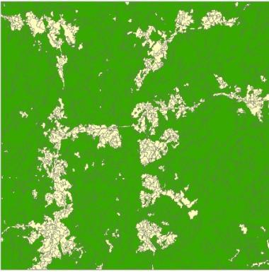
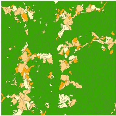
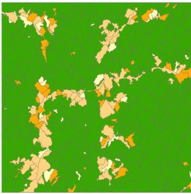
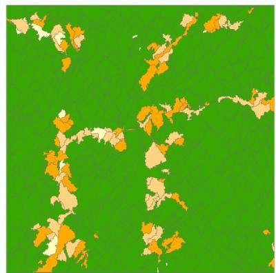
19 Results of monitoring Congo Basin forest using UCL methodology AGGREGATION LABELS (L1) at Level (L2) Shrub Forêt Non Forêt Mosaïque basse Mosaïque haute Eau No data (cloud, shadow)

20 Results of monitoring Congo Basin forest using CARPE/UMD/SDSU methodology


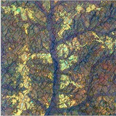
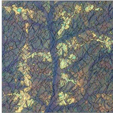
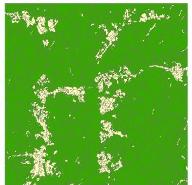
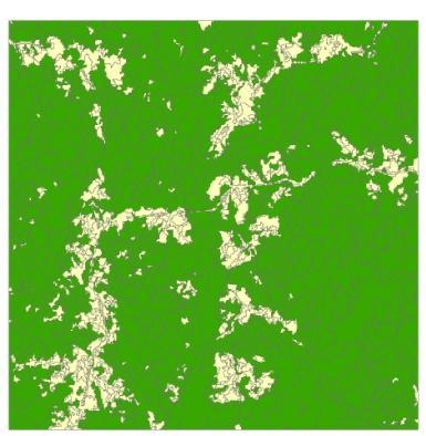
21 Geospatial Monitoring of Forest Resources Expansion of the rural complex and logging roads north of Bumba Deforestation in red

22 Geospatial Monitoring of Forest Resources Inundated Forest characterization In Congo Basin

23 Constraints of using satellite images (Example of Landsat images with clouds)
24 Regional Constraints for Satellite-based Forest Monitoring Need for systematic data acquisition strategy across the basin Challenge of acquiring adequate cloud free data across the basin (optical sensors) Need for consistent forest characterization across basin Challenge of monitoring forest degradation (vs. deforestation) Need to use data from a variety of sensors (e.g., probably not feasible to derive biomass from optical data alone) Need for systematic field data collection to supplement and validate remote sensing data products Need for a regional satellite data dissemination mechanism (poor internet access)


25 GOFC - GOLD contribution for data accessibility by networks Global Observation of Forest Cover (GOFC) + Global Observation of Land cover Dynamics (GOLD) = GOFC-GOLD


 ± 600 images covering the entirety of the Congo Basin and a")
26 Improve the availability and the access to satellite data for the Central African Region Distribution of freely-available satellite data and products ASTER ±2500 images covering the major part of the zones of the congo basin (period: 2000 to 2008 SRTM Feb Landsat images covering the entirety of the basin (of to 2008) ± 600 images covering the entirety of the Congo Basin and a mosaic of the totality of the Basin
27 This presentation has shown through examples the important role played by satellite images in the inventory, monitoring and forest resources characterization Remote sensing can contribute to the implementation of strategic axis of the Convergence Plan of COMIFAC, particularly, on aspects relating to Knowledge of forest resources : inventory of forest resources geospatial monitoring of forest resources.
28 have close collaboration between existing (OSFAC,OFAC) and future centers involved in forest monitoring Future prospects For remote sensing plays its full role in the implementation of Convergence Plan of COMIFAC, it should necessary to: Improve the availability and access to satellite data strengthen capacity of forest managers in processing and use of satellite data combine field and remote sensing studies for monitoring forest cover, forest dynamics and biomass (carbon stock estimation). combine use of the optical and radar data
29 Recommendations To improve the accessibility of satellite data Focus international attention on this critical region and encourage the space agencies to bring this region under continuous monitoring Encourage the agencies to consider free and open sharing of data for this region and seek solutions to the current obstacles to data access with special consideration of African internet limitations Encourage donors to coordinate their various satellite monitoring activities
30 Thank You
Forest and Land Cover Monitoring by Remote Sensing Data Analysis
 Low Carbon Asia Research Network (LoCARNet) 3rd Annual Meeting Bogor, Indonesia November 24 26, 2014 Forest and Land Cover Monitoring by Remote Sensing Data Analysis Muhammad Ardiansyah Center for Climate
Integration methods for forest degradation assessment and change monitoring
 VTT TECHNICAL RESEARCH CENTRE OF FINLAND LTD Joint GFOI / GOFC-GOLD / CONABIO / SilvaCarbon R&D Expert and Capacity Building workshop on: Regional solutions to forest type stratification and characterising
Mapping the world s forests: work by FAO and partners in the global Forest Resource Assessment (FRA) Mette L. Wilkie Adam Gerrand FAO
 Mette L. Wilkie Adam Gerrand FAO") Mapping the world s forests: work by FAO and partners in the global Forest Resource Assessment (FRA) Mette L. Wilkie Adam Gerrand FAO www.fao.org/forestry/fra2010 Main points Challenges unprecedented global
Mapping the world s forests: work by FAO and partners in the global Forest Resource Assessment (FRA) Mette L. Wilkie Adam Gerrand FAO www.fao.org/forestry/fra2010 Main points Challenges unprecedented global
Forest Changes and Biomass Estimation
 Forest Changes and Biomass Estimation Project Title: Comparative Studies on Carbon Dynamics in Disturbed Forest Ecosystems: Eastern Russia and Northeastern China Supported by NASA Carbon Cycle Science
Current Status of NFMIS in Myanmar & How MOLI data can Contribute to the ongoing Efforts. Myat Su Mon, Forest Department, Myanmar
 Current Status of NFMIS in Myanmar & How MOLI data can Contribute to the ongoing Efforts Myat Su Mon, Forest Department, Myanmar 26-05-2017 1 Presentation Outlines Background Information Challenges for
Announcement TE AM Agenda and Talks Reorganized. See Registration Desk
 Announcement TE AM Agenda and Talks Reorganized See Registration Desk Review of LCLUC Observations and Data and Land Use Chris Justice LCLUC Program Scientist University of Maryland LCLUC Program Objectives
A global perspective on land use and cover change
 A global perspective on land use and cover change Alan Belward The Global Environment Monitoring Unit Institute for Environment and Sustainability European Commission Joint Research Centre 21027 Ispra
FOREST COVER MAPPING AND GROWING STOCK ESTIMATION OF INDIA S FORESTS
 FOREST COVER MAPPING AND GROWING STOCK ESTIMATION OF INDIA S FORESTS GOFC-GOLD Workshop On Reducing Emissions from Deforestations 17-19 April 2007 in Santa Cruz, Bolivia Devendra PANDEY Forest Survey of
Use of Earth Observation Data for Water Resources Management by the Nile Basin Initiative. - Tigernet Project
 Use of Earth Observation Data for Water Resources Management by the Nile Basin Initiative. - Tigernet Project By Milly Mbuliro GIS/ Remote Sensing Specialist Nile Basin Initiative Secretariat 25-27 March,
FOREST AND FOREST CHANGE MAPPING WITH C- AND L-BAND SAR IN LIWALE, TANZANIA
 FOREST AND FOREST CHANGE MAPPING WITH C- AND L-BAND SAR IN LIWALE, TANZANIA J. Haarpaintner a, C. Davids a, H. Hindberg a, E. Zahabu b, R.E. Malimbwi b a Norut, P.O. Box 6434, Tromsø Science Park, N-9294
MONITORING LAND USE AND LAND USE CHANGES IN FRENCH GUIANA BY OPTICAL REMOTE SENSING
 MONITORING LAND USE AND LAND USE CHANGES IN FRENCH GUIANA BY OPTICAL REMOTE SENSING Photo : Valéry Gond Photo : Valéry Gond Photo Photo : Gaëlle : : Valéry VERGER Gond Gaëlle VERGER ONF, French National
The Observatory for Central African Forests (OFAC):
:") The Observatory for Central African Forests (OFAC): A regional platform at the service of forest policies Philippe Mayaux European Commission Joint Research Centre Observatoire des Forêts d Afrique Centrale
The Observatory for Central African Forests (OFAC): A regional platform at the service of forest policies Philippe Mayaux European Commission Joint Research Centre Observatoire des Forêts d Afrique Centrale
HYDROLOGY AND WATER RESOURCES REMOTE SENSING IN SOIL AND WATER RESOURCE MANAGEMENT
 Ninth International Water Technology Conference, IWTC9 2005, Sharm El-Sheikh, Egypt 689 HYDROLOGY AND WATER RESOURCES REMOTE SENSING IN SOIL AND WATER RESOURCE MANAGEMENT Behrooz Sari Sarraf*, S. Reza
Remote Sensing and the Kyoto Protocol: A Review of Available and Future Technology for Monitoring Treaty Compliance
 Remote Sensing and the Kyoto Protocol: A Review of Available and Future Technology for Monitoring Treaty Compliance Ann Arbor, Michigan, USA, October 20-22, 1999 Workshop Report Edited by: Å. Rosenqvist,
The role of Remote Sensing in Irrigation Monitoring and Management. Mutlu Ozdogan
 The role of Remote Sensing in Irrigation Monitoring and Management Mutlu Ozdogan Outline Why do we care about irrigation? Remote sensing for irrigated agriculture What are the needs of irrigators? Future
Using global datasets for biomass and forest area estimation: Miombo forests in Tanzania
 Using global datasets for biomass and forest area estimation: Miombo forests in Tanzania Erik Næsset, Terje Gobakken, Hans Ole Ørka (NMBU, Norway) 2111 2005 Objectives Quantify and compare precision of
GEOGLAM international cooperation activities
 GEOGLAM international cooperation activities Chris Justice Center for Global Agricultural Monitoring and Research Dept. of Geographical Sciences University of Maryland GEO: an International Coordinating
Tiger project #2 : Biomass evaluation of tropical dry and wet forests. Climate change impacts
 Tiger II Workshop Hartebeeshoek, South Africa, 12 13 December 2011 Tiger project #2 : Biomass evaluation of tropical dry and wet forests. Climate change impacts Laboratory Institution Partners Project
Earth Observation for Sustainable Development of Forests (EOSD) - A National Project
 - A National Project") Earth Observation for Sustainable Development of Forests (EOSD) - A National Project D. G. Goodenough 1,5, A. S. Bhogal 1, A. Dyk 1, R. Fournier 2, R. J. Hall 3, J. Iisaka 1, D. Leckie 1, J. E. Luther
Earth Observation for Sustainable Development of Forests (EOSD) - A National Project D. G. Goodenough 1,5, A. S. Bhogal 1, A. Dyk 1, R. Fournier 2, R. J. Hall 3, J. Iisaka 1, D. Leckie 1, J. E. Luther
Wolf Forstreuter Pacific Community (SPC)
") K&C Phase 4 Status report Improving Forest and Carbon Monitoring in the Pacific Island Region Wolf Forstreuter Pacific Community (SPC) Science Team meeting #22 Tokyo, Japan, February 16-18, 2016 Pacific
K&C Phase 4 Status report Improving Forest and Carbon Monitoring in the Pacific Island Region Wolf Forstreuter Pacific Community (SPC) Science Team meeting #22 Tokyo, Japan, February 16-18, 2016 Pacific
TAKING STOCK OF OUR FORESTS
 Measurement, Reporting and Verification (MRV) systems are expected to be a crucial part of any future international climate agreement, including Reducing Emissions from Deforestation and forest Degradation,
KEEPING AN EYE ON SDG 15. Working with countries to measure indicators for forests and mountains
 KEEPING AN EYE ON SDG 15 Working with countries to measure indicators for forests and mountains FORESTS AND MOUNTAINS IN THE SUSTAINABLE DEVELOPMENT GOALS The 2030 Agenda for Sustainable Development and
REDD-COMIFAC Meeting March 2008, Paris. REDD Pilot Project COMIFAC: Cameroon. T. Haeusler, S. Gomez
 REDD-COMIFAC Meeting 10-12 March 2008, Paris R e d u c i n g E m i s s i o n s f r o m D e f o r e s t a t i o n a n d D e g r a d a t i o n REDD Pilot Project COMIFAC: Cameroon T. Haeusler, S. Gomez Consortium
LAND AND WATER - EARTH OBSERVATION INFORMATICS FSP
 Earth Observation for Water Resources Management Arnold Dekker,Juan P Guerschman, Randall Donohue, Tom Van Niel, Luigi Renzullo,, Tim Malthus, Tim McVicar and Albert Van Dijk LAND AND WATER - EARTH OBSERVATION
ESA UNCLASSIFIED - For Official Use
 ESA UNCLASSIFIED - For Official Use Forestry TEP Renne Tergujeff VTT Technical Research Centre of Finland Ltd ESA UNCLASSIFIED - For Official Use Objective of Forestry TEP (F-TEP) One-stop shop for forestry
Australia s National Carbon Accounting System. Gary Richards, Robert Waterworth and Shanti Reddy Department of Climate Change Australian Government
 Australia s National Carbon Accounting System Gary Richards, Robert Waterworth and Shanti Reddy Department of Climate Change Australian Government Presentation Outline Objectives Key Features of NCAS NCAS
Remote sensing: A suitable technology for crop insurance?
 Remote sensing: A suitable technology for crop insurance? Geospatial World Forum 2014 May 9, 2014, Geneva, Switzerland Agenda 1. Challenges using RS technology in crop insurance 2. Initial situation Dominance
JICA s Cooperation for. Sustainable Forest. Management
 JICA s Cooperation for Sustainable Forest Management 9 March 2016 GOSEKI Kazuhiro Forestry & Nature Conservation Group, Global Environment Department, Japan International Cooperation Agency Outline of
To provide timely, accurate, and useful statistics in service to U.S. agriculture
 NASS MISSION: To provide timely, accurate, and useful statistics in service to U.S. agriculture What does NASS do? Administer USDA s Statistical Estimating Program Conduct the 5-year Census of Agriculture
Presentation of the Congo Basin countries
 UNFCCC Workshop on Reducing Emissions from Deforestation in Developing Countries 30 August - 1 September 2006 Rome, Italy Presentation of the Congo Basin countries The second tropical forest in the world
LiDAR based sampling for subtle change, developments, and status
 LiDAR based sampling for subtle change, developments, and status Erik Næsset Norwegian University of Life Sciences, Norway 2111 2005 Conclusions: 1. LiDAR is an extremely precise tool for measuring forest
Monitoring Deforestation and Forest Degradation on National and Local Level in Indonesia
 Monitoring Deforestation and Forest Degradation on National and Local Level in Indonesia Dr. Ir. Ruandha A. Sugardiman, M.Sc. Dr. Ir. Belinda A. Margono, M.Sc. Ministry of Environment and Forestry Indonesia
UrtheCast s Vision for the Democratization of Earth Observation
 UrtheCast s Vision for the Democratization of Earth Observation Fabrizio Pirondini, CEO Deimos Imaging & GM Earth Observation UrtheCast Geospatial World Forum 2016, Rotterdam, The Netherlands, 23 May 2016
Rice crop monitoring using EO data in the Mekong Delta, Vietnam
 The 10th GEOSS Asia-Pacific Symposium WG5: Agriculture and Food Security Hanoi, 18-20 th, Sep. 2017 Rice crop monitoring using EO data in the Mekong Delta, Vietnam Lam Dao Nguyen, Hoang Phi Phung, Dang
Existing products and tools for country support
 NFMS and MRV FAO Forestry Existing products and tools for country support FAO Forestry www.fao.org/forestry Country Level HQ Level NFMS/MRV cooperation and coordination at HQ and national level P&Ms UN-REDD
Good Practice of the Preparation of Information System. Central Africa Case of the Democratic Republic of the Congo
 Japan International Cooperation Agency Ministry of Environment, Nature Conservation and Sustainable Development Directorate of Inventory and Management (DIAF) Good Practice of the Preparation of Information
User Awareness & Training: LAND. Tallinn, Estonia 9 th / 10 th April 2014 GAF AG
 User Awareness & Training: LAND Tallinn, Estonia 9 th / 10 th April 2014 GAF AG Day 2 - Contents LAND (1) General Introduction to EO and the COPERNICUS Sentinel Programme Overview of COPERNICUS/GMES LAND
K&C Phase 3 Brief project essentials. Climate-Relevant Modernization of the National Forest Policy and Piloting of REDD+ Measures in the Philippines
 K&C Phase 3 Brief project essentials Climate-Relevant Modernization of the National Forest Policy and Piloting of REDD+ Measures in the Philippines Francisco B. Tavora, Jr. 1, Jose Don T. De Alban 2, Enrico
Monitoring Natural Sal Forest Cover in Modhupur, Bangladesh using Temporal Landsat Imagery during
 Monitoring Natural Sal Forest Cover in Modhupur, Bangladesh using Temporal Landsat Imagery during 1972 2015 Hasan Muhammad Abdullah *, M. Golam Mahboob, Md.Mezanur Rahman, Tofayel Ahmed * Assistant Professor,
Comparing Lidar, InSAR, RapidEye optical, and global Landsat and ALOS PALSAR maps for forest area estimation
 Comparing Lidar, InSAR, RapidEye optical, and global Landsat and ALOS PALSAR maps for forest area estimation Erik Næsset, Hans O. Ørka, Ole M. Bollandsås, Endre H. Hansen, Ernest Mauya, Terje Gobakken
CID Survey Report. Satellite Imagery and Associated Services used by the JRC. Current status and future needs
 EUROPEAN COMMISSION DIRECTORATE GENERAL JRC JOINT RESEARCH CENTRE ISPRA Institute for the Protection and Security of the Citizen Agriculture and Fisheries Unit JRC IPSC/G/C/PAR/pha D(7)(78) / JRC Scientific
Intersection of SAR imagery with medium resolution DEM for the estimation of regional water storage changes
 Intersection of SAR imagery with medium resolution DEM for the estimation of regional water storage changes Sonya Spiridonova 1, Karin Hedman 1, Florian Seitz 2 1 Earth Oriented Space Science and Technology
Regreening the Sahel and Farmer Managed Natural Regeneration: What the Satellite Imagery Shows
 Regreening the Sahel and Farmer Managed Natural Regeneration: What the Satellite Imagery Shows First Drylands Week June 10-17, 2011 Dakar, Senegal Gray Tappan, U.S. Geological Survey Earth Resources Observation
Forest change detection and monitoring using passive and active remote sensing data (RS4FOR project)
") Forest change detection and monitoring using passive and active remote sensing data (RS4FOR project) Katarzyna Staszyńska, Ewa Grabska, Anna Zielonka, Katarzyna Ostapowicz Institute of Geography and Spatial
Forest change detection and monitoring using passive and active remote sensing data (RS4FOR project) Katarzyna Staszyńska, Ewa Grabska, Anna Zielonka, Katarzyna Ostapowicz Institute of Geography and Spatial
Forest Biomass Change Detection Using Lidar in the Pacific Northwest. Sabrina B. Turner Master of GIS Capstone Proposal May 10, 2016
 Forest Biomass Change Detection Using Lidar in the Pacific Northwest Sabrina B. Turner Master of GIS Capstone Proposal May 10, 2016 Outline Relevance of accurate biomass measurements Previous Studies Project
DMC 22m Sensors for Supertemporal Land Cover Monitoring. Gary Holmes DMC International Imaging Ltd June 2014
 DMC 22m Sensors for Supertemporal Land Cover Monitoring Gary Holmes DMC International Imaging Ltd June 2014 DMC 2 nd Generation Satellites UK-DMC2 and Deimos-1 launched 29 th July 2009 650km swath width
Application of PALSAR data to classify vegetation in an anthropogenically affected wetland area in Central Spain (Las Tablas de Daimiel)
") Rhodes, Greece, Application of PALSAR data to classify vegetation in an anthropogenically affected wetland area in Central Spain (Las Tablas de Daimiel) Thomas Schmid 1, Magaly Koch 2, Jesús Solana 3 and
Rhodes, Greece, Application of PALSAR data to classify vegetation in an anthropogenically affected wetland area in Central Spain (Las Tablas de Daimiel) Thomas Schmid 1, Magaly Koch 2, Jesús Solana 3 and
SOIL MOISTURE RETRIEVAL FROM OPTICAL AND THERMAL SPACEBORNE REMOTE SENSING
 Comm. Appl. Biol. Sci, Ghent University, 70/2, 2005 1 SOIL MOISTURE RETRIEVAL FROM OPTICAL AND THERMAL SPACEBORNE REMOTE SENSING W.W. VERSTRAETEN 1,2 ; F. VEROUSTRAETE 2 ; J. FEYEN 1 1 Laboratory of Soil
Fragmentation of tropical forests a forgotten process in the global carbon cycle?
 Fragmentation of tropical forests a forgotten process in the global carbon cycle? A. Huth 1,2, K. Brinck 1,3, R. Fischer 1, J. Groeneveld 1, S. Puetz 1 1 Helmholtz Centre for Environmental Research, Leipzig,
INTRODUCTION cont. INTRODUCTION. What is Impervious Surface? Implication of Impervious Surface
 Mapping Impervious Surface Changes In Watersheds In Part Of South Eastern Region Of Nigeria Using Landsat Data By F. I. Okeke Department of Geoinformatics and Surveying, University of Nigeria, Enugu Campus
Forest Carbon Partnership Facility (FCPF) Participants Committee (PC23) Meeting. March 27-29, 2017, Washington DC
 Participants Committee (PC23) Meeting. March 27-29, 2017, Washington DC") Forest Carbon Partnership Facility (FCPF) Participants Committee (PC23) Meeting Update on Gabon s Readiness progress March 27-29, 2017, Washington DC 1 Agenda I. Characteristics and challenge of Gabon
Forest Carbon Partnership Facility (FCPF) Participants Committee (PC23) Meeting Update on Gabon s Readiness progress March 27-29, 2017, Washington DC 1 Agenda I. Characteristics and challenge of Gabon
A look past and a look forward. David Skole Michigan State University
 A look past and a look forward David Skole Michigan State University Antecedents ca. 1988-94 There were important antecedents to the NASA LCLUC program Two important drivers: Large scale Landsat databases
Remotely-Sensed Fire Danger Rating System to Support Forest/Land Fire Management in Indonesia
 Remotely-Sensed Fire Danger Rating System to Support Forest/Land Fire Management in Indonesia Orbita Roswintiarti Indonesian National Institute of Aeronautics and Space (LAPAN) SE Asia Regional Research
Joint GFOI/GOFC-GOLD Expert Workshop 2: Approaches to monitoring forest degradation for REDD+
 Joint GFOI/GOFC-GOLD Expert Workshop 2: Approaches to monitoring forest degradation for REDD+ Forest carbon monitoring for REDD MRV with satellite 3D SAR Svein Solberg Norwegian Forest and Landscape Institute
Global Biomass Map Products
 Global Biomass Map Products Maurizio Santoro (santoro@gamma-rs.ch) & GlobBiomass team Status of global biomass datasets at UW3 A first version of the global AGB and GSV datasets were delivered to ESA and
Forest Monitoring in Tropical Regions
 Forest Monitoring in Tropical Regions Manuela Hirschmugl & Mathias Schardt Institute of Digital Image Processing, Joanneum Research Content: 1. Background 2. Data 3. Methods 3.1. Pre-processing 3.2. Segmentation
User Contact. Greenhouse Gas Reporting (GHG) for Kyoto
 for Kyoto") F+S_Service case_neu.qxd 23.10.2006 12:51 Uhr Seite 1 SWITZERLAND Client Profile The Federal Office for the Environment (FOEN) and specifically the Federal Department of Environment, Transport, Energy
F+S_Service case_neu.qxd 23.10.2006 12:51 Uhr Seite 1 SWITZERLAND Client Profile The Federal Office for the Environment (FOEN) and specifically the Federal Department of Environment, Transport, Energy
Available online at Received 15 November 2006; received in revised form 18 July 2007; accepted 21 July 2007
 Available online at www.sciencedirect.com Remote Sensing of Environment 112 (2008) 1969 1981 www.elsevier.com/locate/rse Deforestation in Central Africa: Estimates at regional, national and landscape levels
OneMap Myanmar Project and Updates
 International Meeting on Land Use and Emission in South/Southeast Asia Ho Chi Minh City, Vietnam, 17 th -19 th October 2016 OneMap Myanmar Project and Updates Myat Su Mon Forest Department, Myanmar Presentation
GeoCarb. PI: Berrien OU (Leadership, science analysis)
") PI: Berrien Moore @ OU (Leadership, science analysis) Partner Institutions: Lockheed-Martin (instrument) CSU (Algorithms) NASA Ames (Validation) GeoCarb A NASA Earth-Ventures mission, awarded in Dec 2016,
PI: Berrien Moore @ OU (Leadership, science analysis) Partner Institutions: Lockheed-Martin (instrument) CSU (Algorithms) NASA Ames (Validation) GeoCarb A NASA Earth-Ventures mission, awarded in Dec 2016,
Detecting deforestation with multitemporal L-band SAR imagery: a case study in western Brazilian Amazônia
 INT. J. REMOTE SENSING INPE eprint: sid.inpe.br/eprint@80/2006/12.08.13.17 v1 2006-12-09 2006, 1 8, PrEview article Detecting deforestation with multitemporal L-band SAR imagery: a case study in western
GEO-FCT Product Development Team 2012 Technical Status Report (v. 1.0) 18 October 2012
 18 October 2012") GEO-FCT Product Development Team 2012 Technical Status Report (v. 1.0) 18 October 2012 GEO FOREST CARBON TRACKING Page 1 ! Table of Contents Contents' Table of Contents 2! 1! Introduction 3! 1.1! GEO FCT
GEO-FCT Product Development Team 2012 Technical Status Report (v. 1.0) 18 October 2012 GEO FOREST CARBON TRACKING Page 1 ! Table of Contents Contents' Table of Contents 2! 1! Introduction 3! 1.1! GEO FCT
Introducing the Moors for the Future Pilot, Peak District National Park
 Introducing the Moors for the Future Pilot, Peak District National Park Winner of The Copernicus Masters Sustainable Living Challenge 2016 Gail Millin-Chalabi Ioanna Tantanasi Adam Johnston Team based
Assessment of areas of selective logging and burned forests in Mato Grosso State, Brazil, from satellite imagery
 XIV WORLD FORESTRY CONGRESS, Durban, South Africa, 7-11 September 2015 Assessment of areas of selective logging and burned forests in Mato Grosso State, Brazil, from satellite imagery Yosio Edemir Shimabukuro
ROLE OF REMOTE SENSING AND GIS IN FORESTRY
 ROLE OF REMOTE SENSING AND GIS IN FORESTRY MEGHA GUPTA 1, ANKITA KHARE 2 & SRASHTI PATHAK 3 1,2,3 Student(cs),IITM Gwalior, Gwalior Email:meghagupta492@yahoo.com, ankita.khare27@gmail.com, srashti.cseengg@gmail.com
EVALUATING THE ACCURACY OF 2005 MULTITEMPORAL TM AND AWiFS IMAGERY FOR CROPLAND CLASSIFICATION OF NEBRASKA INTRODUCTION
 EVALUATING THE ACCURACY OF 2005 MULTITEMPORAL TM AND AWiFS IMAGERY FOR CROPLAND CLASSIFICATION OF NEBRASKA Robert Seffrin, Statistician US Department of Agriculture National Agricultural Statistics Service
Tools Development and Outcomes. Dave Skole Michigan State University
 Tools Development and Outcomes Dave Skole Michigan State University Background Carbon2Markets Carbon Climate Livelihoods Focus of our work is on a range of issues in Carbon Measurement Forests, woodlands,
GEO GFOI 19-23, 2015 INPE
 12 th Regional Workshop on Forest Monitoring GEO GFOI Early Warning Systems for Deforestation Report January 19-23, 2015 INPE Headquarters, São José Dos Campos, Brazil Meeting Objective: The main objective
A REVIEW OF FOREST FIRE INFORMATION TECHNOLOGIES IN VIETNAM
 A REVIEW OF FOREST FIRE INFORMATION TECHNOLOGIES IN VIETNAM Le Thanh Ha 1, Nguyen Hai Chau 1, Nguyen Hoang Nam 1, Bui Quang Hung 1, Nguyen Thi Nhat Thanh 1, Nguyen Ba Tung 1, Do Khac Phong 1, Nguyen Van
DISASTER RESPONSE IN AFRICA BY THE INTERNATIONAL CHARTER
 DISASTER RESPONSE IN AFRICA BY THE INTERNATIONAL CHARTER Ahmed Mahmood *, Canadian Space Agency, Saint-Hubert (Quebec), Canada, J3Y 8Y9, Ahmed.Mahmood@space.gc.ca Eliane Cubero-Castan, Centre National
PRODES - INPE INPE. PRODES Methodology- PRODES Methodology - INPE. Mapping and Monitoring Deforestation and Forest Degradation in the Brazilian Amazon
 Mapping and Monitoring Deforestation and Forest Degradation in the Brazilian Amazon GOFC-GOLD GOLD Symposium on Forest and Land Cover Observations March 21st-26 26 th, 2006 Jena, Germany Carlos Souza Jr.
Indonesia Burning The Impact of Fire on Tropical Peatlands : Focus on Central Kalimantan
 Indonesia Burning The Impact of Fire on Tropical Peatlands : Focus on Central Kalimantan A collaborative research programme: *Sue Page, Univ. of Leicester, UK *Jack Rieley, Univ. of Nottingham, UK *Florian
Land Use/Land Cover Change Research and Management in Vietnam
 NASA-LCLUC Science Team Joint Meeting with MAIRS, GOFCGOLD and SEA START on LC/LU Change Processes in Monsoon Asia Region Jan.12-17, 2009 Land Use/Land Cover Change Research and Management in Vietnam By:
Input to UNFF8 by the Southern African Development Community (SADC)
") Preamble Input to UNFF8 by the Southern African Development Community (SADC) All SADC member states signed and ratified the UN Framework Convention on Climate Change, the Kyoto Protocol, Convention on
Preamble Input to UNFF8 by the Southern African Development Community (SADC) All SADC member states signed and ratified the UN Framework Convention on Climate Change, the Kyoto Protocol, Convention on
Remote sensing technology contributes towards food security of Bangladesh
 American Journal of Remote Sensing 2013; 1(3): 67-71 Published online June 20, 2013 (http://www.sciencepublishinggroup.com/j/ajrs) doi: 10.11648/j.ajrs.20130103.12 Remote sensing technology contributes
Monitoring Crop Leaf Area Index (LAI) and Biomass Using Synthetic Aperture Radar (SAR)
 and Biomass Using Synthetic Aperture Radar (SAR)") Monitoring Crop Leaf Area Index (LAI) and Biomass Using Synthetic Aperture Radar (SAR) Mehdi Hosseini, Heather McNairn, Andrew Davidson, Laura Dingle-Robertson *Agriculture and Agri-Food Canada JECAM SAR
Monitoring Crop Leaf Area Index (LAI) and Biomass Using Synthetic Aperture Radar (SAR) Mehdi Hosseini, Heather McNairn, Andrew Davidson, Laura Dingle-Robertson *Agriculture and Agri-Food Canada JECAM SAR
Satellite Based Crop Monitoring and Estimation System for Food Security Application in Bangladesh
 Satellite Based Crop Monitoring and Estimation System for Food Security Application in Bangladesh Dr. Hafizur Rahman Head, Agriculture Division Bangladesh Space Research and Remote Sensing Organization
Forestry Department Food and Agriculture Organization of the United Nations FRA 2000 GLOBAL FOREST COVER MAP. Rome, November 1999
 Forestry Department Food and Agriculture Organization of the United Nations FRA 2000 GLOBAL FOREST COVER MAP Rome, November 1999 Forest Resources Assessment Programme Working Paper 19 Rome 1999 The Forest
Mapping water constituents concentrations in estuaries using MERIS full resolution satellite data
 Mapping water constituents concentrations in estuaries using MERIS full resolution satellite data David Doxaran, Marcel Babin Laboratoire d Océanographie de Villefranche UMR 7093 CNRS - FRANCE In collaboration
Using Landsat TM Imagery to Estimate LAI in a Eucalyptus Plantation Rebecca A. Megown, Mike Webster, and Shayne Jacobs
 Using Landsat TM Imagery to Estimate LAI in a Eucalyptus Plantation Rebecca A. Megown, Mike Webster, and Shayne Jacobs Abstract The use of remote sensing in relation to determining parameters of the forest
Integrating field and lidar data to monitor Alaska s boreal forests. T.M. Barrett 1, H.E. Andersen 1, and K.C. Winterberger 1.
 Integrating field and lidar data to monitor Alaska s boreal forests T.M. Barrett 1, H.E. Andersen 1, and K.C. Winterberger 1 Introduction Inventory and monitoring of forests is needed to supply reliable
THE ASSESSMENT OF RAPID LANDUSE CHANGE AND ITS IMPACT ON SUSTAINABLE FISHERIES
 THE ASSESSMENT OF RAPID LANDUSE CHANGE AND ITS IMPACT ON SUSTAINABLE FISHERIES By: Dewayany Sutrisno National Coordination Agency For Survey And Mapping - Indonesia e-mail: dewayani@bakosurtanal.go.id
Towards a European Forest Fire Simulator
 Towards a European Forest Fire Simulator J.M. Baetens Research Unit Knowledge-based Systems Ghent University COST Green Engineering Camp July 2, 2012 KERMIT J.M. Baetens (KERMIT) A European Forest Fire
Operational products for crop monitoring. Hervé Kerdiles, JRC MARS
 Operational products for crop monitoring Hervé Kerdiles, JRC MARS Outline Meteo products Rainfall, temperature, global radiation, ETa, snow depth Biomass indicators & crop yield prediction NDVI & other
POTENTIAL IMPROVEMENT FOR FOREST COVER AND FOREST DEGRADATION MAPPING WITH THE FORTHCOMING SENTINEL-2 PROGRAM
 POTENTIAL IMPROVEMENT FOR FOREST COVER AND FOREST DEGRADATION MAPPING WITH THE FORTHCOMING SENTINEL-2 PROGRAM L. Hojas-Gascón a, d, A. Belward a, H. Eva a*, G. Ceccherini a, O. Hagolle b, J. Garcia c,
Monitoring and Assessment of Drylands: Forests, Rangelands, Trees, and Agrosilvopastoral Systems
 Workshop on Monitoring and Assessment of Drylands: Forests, Rangelands, Trees, and Agrosilvopastoral Systems Combining local surveillance and spatial observation for environmental monitoring in the Circum-Sahara:
2. Relevant operational framework(s)
") Inputs provided by: International Center of Insect Physiology and Ecology (ICIPE), Nairobi, Kenya 1. General description of mandates and objective(s) of your organization / associated network with institutional
Inputs provided by: International Center of Insect Physiology and Ecology (ICIPE), Nairobi, Kenya 1. General description of mandates and objective(s) of your organization / associated network with institutional
Annual Deforestation Mapping in Sumatera using multi temporal digital classification
 Annual Deforestation Mapping in Sumatera 1990-2014 using multi temporal digital classification Kustiyo Remote Sensing Technology and Data Center LAPAN International Workshop on Land Use/Cover Change and
2014REDD302_41_JCM_PM_ver01
 Joint Crediting Mechanism Proposed Methodology Form Cover sheet of the Proposed Methodology Form Form for submitting the proposed methodology Host Country Indonesia Name of the methodology proponents Mitsubishi
Mid-term report & request for additional funding Madagascar
 FCPF PC22 Meeting Accra, Ghana 26 th to 30 th of September 2016 Mid-term report & request for additional funding Madagascar 1 Outline 1. General and historical context 2. Progress made on REDD+ preparation
Developing and testing Airborne LiDAR-Based Sampling Procedures for Regional Forest Biomass and Carbon Estimation On-going and New Initiatives
 Developing and testing Airborne LiDAR-Based Sampling Procedures for Regional Forest Biomass and Carbon Estimation On-going and New Initiatives Erik Næsset Norwegian University of Life Sciences Dept. of
Forest Carbon Accounting for REDD+ Readiness at District and FMU Level Experiences from Kalimantan
 Indonesian-German Forests and Climate Change Programme (FORCLIME) Forest Carbon Accounting for REDD+ Readiness at District and FMU Level Experiences from Kalimantan Jakarta, 03.03.2015 Franz-Fabian Bellot
RESTORE+: Addressing Landscape Restoration for Degraded Land in Indonesia and Brazil. Picture credit Stora Enso
 RESTORE+: Addressing Landscape Restoration for Degraded Land in Indonesia and Brazil Picture credit Stora Enso IMPORTANCE OF RESTORATION Bonn Challenge and Global Partnership on Forest Landscape Restoration
Using Remote Sensing to Map and Monitor Water Resources in Arid and Semiarid Regions
 Using Remote Sensing to Map and Monitor Water Resources in Arid and Semiarid Regions Victor Klemas and Aline Pieterse Contents 1 Introduction... 34 2 Identification and Mapping of Arid and Semiarid Regions...
WORKSHOP REPORT: SHIFTING CULTIVATION, GENDER AND REDD+ IN WEST AND CENTRAL AFRICA
 WORKSHOP REPORT: SHIFTING CULTIVATION, GENDER AND REDD+ IN WEST AND CENTRAL AFRICA Washington, DC 20 July 2012 Forest Carbon, Markets and Communities (FCMC) Program NOVEMBER 2012 www.fcmcglobal.org CONTENTS
A Remote Sensing Based Urban Tree Inventory for the Mississippi State University Campus
 A Remote Sensing Based Urban Tree Inventory for the Mississippi State University Campus W. H. Cooke III a and S.G. Lambert b a Geosciences Department, GeoResources Institute, Mississippi State University,
On SEBI-SEBS validation in France, Italy, Spain, USA and China
 On SEBI-SEBS validation in France, Italy, Spain, USA and China Massimo Menenti Li Jia 2 and ZongBo Su 2 - Laboratoire des Sciences de l Image, de l Informatique et de la Télédétection (LSIIT), Strasbourg,
The use of satellite pictures and data provided by drones for the purposes of identification of crops and assessment of plant production
 The use of satellite pictures and data provided by drones for the purposes of identification of crops and assessment of plant production Tomasz Milewski Białobrzeska 11/64, 02-379 Warsaw Central Statistical
SOUTHERN INDIANA 2008 FLOODS: DAMAGE ASSESSMENT AND WEB MAPPING
 SOUTHERN INDIANA 2008 FLOODS: DAMAGE ASSESSMENT AND WEB MAPPING Ejaz Hussain KyoHyouk kkim Jie Shan, Associate Professor {ehussain,kim458,jshan}@,j purdue.edu Tel:765-494-2168 School Of Civil Engineering
Mapping global soil Carbon stocks and sequestration potential
 Mapping global soil Carbon stocks and sequestration potential John Latham Renato Cumani UN/FAO Environmental Assessment and Monitoring Unit FAO, Rome, April 16, 2009 1 Food and Agriculture Organization