ANNE ARUNDEL SOIL CONSERVATION DISTRICT EROSION AND SEDIMENT CONTROL PLAN FOR FOREST HARVEST OPERATIONS CHECKLIST (Check attached items)
|
|
|
- Cody Rice
- 5 years ago
- Views:
Transcription
1 ANNE ARUNDEL SOIL CONSERVATION DISTRICT EROSION AND SEDIMENT CONTROL PLAN FOR FOREST HARVEST OPERATIONS CHECKLIST (Check attached items) THESE PLANS MUST BE EXECUTED BY A MARYLAND LICENSED PROFESSIONAL FORESTER ATTACHMENTS 1-4 SEDIMENT AND EROSION CONTROL DETAILS attached to the Plan GRADING PERMIT APPLICATION VICINITY/LOCATION MAP: This map shall delineate the site location, street names and show distances from the nearest major road intersection. Provide map at a legible scale, note the map scale and highlight the site on the vicinity/location map. USGS TOPO MAP: These maps clearly show the location of blue lined streams and can also be utilized as the Vicinity/Location Map. Clearly delineate street names, the site and harvest areas on this map. This scale is not large enough to show all the necessary items required under Site Plan. SITE PLAN: Site plans or sketches shall be prepared for all forest harvests. All access points, property boundaries, harvest areas, existing farm lanes, landings, haul roads, skid trails, steep slopes, all waters of the State, SMZ s, wetlands, uncut/cut buffer areas, and stream crossings must be identified on the site plan or sketch. Said items must be shown in a legend and/or clearly labeled on site plan. A more detailed map of the buffer may be required. Provide a legible map scale (preferably100-scale) and note the map scale on the site plan. The 100-scale base sheet topography and color photo may be obtained from DPW s map room, 2662 Riva Road, Second Floor. This topography map must be clear enough to show the practices necessary to prevent sediment and erosion impacts. CUSTOM EROSION AND SEDIMENT CONTROL PLAN (If applicable): Situations may arise when it is not possible, even with careful planning, to comply with all general requirements of a Standard Plan. In such cases, a Custom Plan is necessary. Two pieces of information must be included in a Custom Plan: 1) a description as to why the Standard Plan requirements cannot be met; and 2) provide the specific erosion and sediment control measures to be used for the forest harvest operation. A sketch or map of the harvest site that identifies this information must be submitted with a Custom Plan. For example, if proposed haul road grade exceeds 15%, and turnouts are to be used to drain water from the road, the location of the turnouts must be noted. If stone is to be installed at the discharge end of the turnout to prevent side bank erosion, then the location of the stone must also be shown. Another example is locating a landing on a slope exceeding 10%. It may be necessary to install reinforced silt fence on the downstream side of the landing to act as a sediment filter. In this case, the location of sediment controls and the type of final stabilization to be used at the landing must be noted on the custom plan. AASCD may require certification of a Custom Plan by a professional engineer, land surveyor, landscape architect, architect or a LPF, verifying that the plan has been designed in accordance with the appropriate erosion and sediment control ordinances, regulations, standards, and criteria. AASCD has the option to require a specific design if a particular situation demands it. In summary, it is important to develop a Custom Plan that identifies the location and describes the specific erosion and sediment controls to be utilized whenever the Standard Plan requirements cannot be met. STREAMSIDE MANAGEMENT ZONE (SMZ) AND SMZ PLAN (If applicable): The establishment of a SMZ is required, at a minimum, along all blue line streams. A SMZ is generally required in lieu of structural measures such as reinforced silt fence, diversion dikes, and sediment traps. Harvesting is allowed within a SMZ provided that a SMZ Plan is prepared by a LPF and approved by AASCD. A SMZ Plan must be very specific when describing which trees are to be cut, what precautions for sediment control will be taken, and where the sediment controls will be located. The location of any harvesting within a SMZ must be identified on a sketch of the SMZ. The sediment controls to be used for waterway protection within the SMZ also must be identified on this sketch. If a SMZ Plan is required, all other Standard or Custom Plan criteria must still be met. If other conditions of the harvest necessitate a Custom Plan, requirements for harvesting within the SMZ will be made a part of the Plan. Each site must be evaluated on its own individual characteristics and limitations. The SMZ Plan must include an executed Attachment #3. 5/2017 LoggingPermit5-2017
2 Attachment #1/Sheet 1 of 1 ANNE ARUNDEL SOIL CONSERVATION DISTRICT EROSION AND SEDIMENT CONTROL PLAN FOR FOREST HARVEST OPERATIONS TYPE OF PLAN: STANDARD PLAN STANDARD PLAN with SMZ PLAN CUSTOM PLAN CUSTOM PLAN with SMZ PLAN I. Site Information A. Location Address B. Specify Type of Operation(s) Check Applicable Operation: chipping firewood clear cut shelter wood cut selection other (specify type) NOTE: THIS PLAN IS VOID IF WORK INVOLVES STUMP REMOVAL OR OTHER LAND DISTURBANCE. C. Total Acres Harvested D. Estimated Acres of Loblolly Pine E. Property Tax Acct. # Parcel # Map # F. Site in Critical Area: Yes No (If yes, provide approval letter from CFB.) II. Landowner and Operator Information A. Landowner(s) Phone Address B. Operator Phone Address Current Forest Product Operator s (FPO) License # Certificate of Training (Green Card) # C. Professional Forester who prepared Plan Phone Address D. If subcontracting to any of the operators listed above, do you assume responsibility for their compliance with the Plan? Yes If no, they must obtain a separate plan prior to their operations. III. Agreement A. I/We agree to adhere to the terms of the AASCD Erosion and Sediment Control Plan for Forest Harvest Operations (Plan) and to hereby authorize the right of entry for periodic on-site evaluation by the Maryland Department of the Environment (MDE) Compliance Inspectors, Anne Arundel County Inspectors and representatives of AASCD. B. I/We am aware of the landowner s responsibilities of preventing accelerated erosion and sedimentation during and subsequent to forest harvest operations as mandated by the rules and regulations adopted by the State of Maryland, local jurisdictions and the 2015 Maryland Soil Erosion and Sediment Control Standards and Specifications for Forest Harvest Operations (2015 Standards). C. I/We agree to require the operator conducting forest harvest operations on my property listed above to adhere to the requirements of this Plan and to have a certificate of attendance from the MDE s Responsible Personnel Certificate Program for Erosion and Sediment Control. D. I/We certify that this Plan has been prepared by the professional forester noted above. E. I/We am responsible for the acquisition of all easements, rights, and/or right of way that may be required for any work and/or discharge of storm water onto or across adjacent or downstream properties. F. The approval of this Plan does not relieve the landowner/operator from complying with federal, state or county requirements pertaining to environmental issues. G. Landowner/operator agree to notify Inspections and Permits ( ) 48 hours prior to and upon completion of harvesting. Landowner Signature Date Landowner Printed Name Operator Signature Date Operator Printed Name (Operator s signature is an acknowledgement that operator understands the requirements.) Approved: Anne Arundel Soil Conservation District Date 5/2017
3 Attachment 2/Sheet 1 of 5 ANNE ARUNDEL SOIL CONSERVATION DISTRICT EROSION AND SEDIMENT CONTROL PLAN FOR FOREST HARVEST OPERATIONS I. General Requirements Maryland State law and regulations require that an erosion and sediment control plan be developed and approved before undertaking any earth-disturbing activity in excess of 5,000 square feet or 100 cubic yards. This requirement applies to construction on residential, commercial, industrial, and institutional sites as well as on forest harvest projects. No stump removal, understory vegetation removal or conversion of woodlands to cropland or pasture will be allowed. This AASCD Plan can be used for forest harvest operations in Anne Arundel County when all of the following Standard Plan requirements are met: 1. No cuts or fills are allowed under this Plan. 2. Grades for haul roads do not exceed 15%. 3. Landings are located on slopes 10% or less. 4. Grades for skid trails do not exceed 20%. 5. The site has no stream crossings. If the above conditions or any other criteria cannot be met, a Custom Plan, based on the 2015 Standards is required. If harvesting is proposed within a Streamside Management Zone (SMZ), a SMZ Plan must accompany this Plan. II. Conditions A. The forest harvest operator working on this site assumes full responsibility for implementing this Plan on behalf of the landowner. An operator is defined as any individual or company which has contracted or subcontracted a portion of the harvest operation. This also applies to those operators conducting firewood cutting or separate forest harvest operations in conjunction with or subsequent to the initial harvest. Each operator must be identified on Attachment 1/Sheet 1 and must implement and maintain the required practices as indicated on the approved Plan. B. The landowner or operator shall notify the Anne Arundel County Department of Inspections and Permits ( ) at least 48 hours prior to commencing forest harvest operations and 48 hours prior to the completion of work. Note: Outstanding site work or outstanding correction orders issued by the inspector must be resolved before any other forest harvest operations can be reviewed and approved on behalf of the landowner or operator. C. A copy of the approved Plan and any applicable SMZ Plan must be available on site during harvest operations and until timber removal operations have been completed. D. Each site will be periodically inspected by local government and/or State inspectors for compliance with the approved Plan. State and local inspectors, as well as AASCD personnel, may require AASCD approved Plan modifications to this Plan as conditions dictate, to prevent movement of sediment from the site.
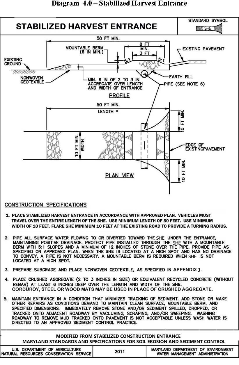
4 Attachment 2/Sheet 2 of 5 E. Failure to properly implement or maintain the practices required by this Plan, or failure to comply with written requirements for corrective action, may result in the operation being stopped (issuance of a stop work order) until the deficiencies have been corrected. Failure to take required corrective action may also result in legal action. Outstanding site work or outstanding correction notices issued by the inspector must be resolved before other forest harvest operations can be reviewed and approved on behalf of the landowner or operator. F. All erosion and sediment controls must be implemented in accordance with specifications contained in the 2015 Standards, available from MDE, Maryland Department of Natural Resources and AASCD s Reinforced Silt Fence detail. G. The issuance of an approval by MDE, a SCD, or a jurisdiction not within a SCD, does not relieve the applicant of the continuing responsibility to effectively abate sediment pollution and to comply with all other applicable local and State laws. III. Plan Requirements A. Site Maps: 1. Site maps shall be prepared for all forest harvests and submitted with the Plan. The maps shall identify the site location and provide directions and distances from the nearest major road intersection. 2. The topo map and site plan/sketch must include scale and text must be both accurate and legible. All access points, property boundaries, harvest areas, existing farm lanes, landings, haul roads, skid trails, steep slopes, waters of the States, SMZ s, wetlands, uncut/cut buffer areas, and stream crossings must be identified on the maps. The harvest area must be delineated on copies of the vicinity map, the United States Geological Survey (USGS) topographic map, and/or any other maps required by AASCD. 3. If harvesting is planned in a SMZ, a more detailed map (larger scale) of the SMZ area is required. Additionally, a SMZ Plan must also accompany the Standard or Custom Plan. The harvest area should be delineated on a photocopy of the USGS 7.5 Minute Series Topographic quadrangle maps. B. Site Access: 1. Access points to the site shall be stabilized with wood chips, corduroy logs, a stone stabilized construction entrance or other methods approved in the 2015 Standards. Any soil or debris which is tracked onto off-site paved roads shall be removed immediately and deposited in a controlled area by the end of each working day. 2. A grading or entrance permit may be required for a new entrance onto a county or state road. Details may be obtained from the appropriate county, city permitting department or State Highway Administration. 3. Existing public road drainage shall not be blocked or damaged by access to the construction area. Pipe culverts shall be installed to maintain existing drainage (if applicable). 4. The stabilized harvest entrance is to be removed at the end of the forest harvest per the 2015 Standards, unless an entrance permit has been obtained from the county, city or State Highway Administration. A copy of the entrance permit must be submitted and made part of the Standard or Custom Plan.
5 Attachment 2/Sheet 3 of 5 C. Waterway Protection: 1. Any required SMZ shall be marked and properly maintained (see specifications for SMZ section.) Uncut buffer zones shall be marked and maintained on all sides of perennial or intermittent streams, rivers, lakes, ponds, bogs, marshes and wetlands. These features are identified on USGS 7.5 Minute Series (topographic) quadrangle maps and on other maps as applicable. 2. The minimum SMZ width is 50 feet on land with no slope (less than 1%). Where sloping land is encountered, the following formula shall be applied: 50 feet + (2 feet x % slope) = SMZ width (to a maximum of 150 feet) Example for 20% Slope: 50 feet + (2 feet x 20%) = 50 feet + 40 feet = 90 feet SMZ Table 2 SMZ Width vs. Site Slope Slope % Width of SMZ (feet) on each side of watercourse Unless part of an approved SMZ Plan, new roads, trails, and harvesting equipment are not allowed in any SMZ except to provide access to authorized stream crossings. 4. Harvesting within the SMZ is not allowed unless a SMZ Plan, along with the approved Plan, is submitted to and approved by AASCD. The SMZ Plan must be prepared by a Licensed Professional Forester (LPF) and include the harvest method, the square footage of basal area to be removed and retained, provisions for removing and restocking the cut trees, and other criteria for the harvest operation. 5. Although not all Waters of the State require the establishment of a SMZ, protecting water quality when harvesting within or near these areas is still required. At a minimum, the following criteria must be adhered to when a SMZ Plan is not required: a. Locating log decks and landings at least 50 feet from any Waters of the State. b. Locating truck haul roads at least 50 feet from any Waters of the State. c. Limiting skidding operations to single-pass trails within 50 feet of any Waters of the State. d. Fell trees away from Waters of the State and remove any slash that enters Waters of the State. e. Avoid crossing Waters of the State. When crossing is unavoidable, required permits must be obtained if a ford or culvert is proposed. f. Stabilize within three days any disturbed areas (damage to the humus layer) within 50 feet of Waters of the State unless other sediment control practices have been installed. 6. Roads, trails, and harvesting equipment shall not be allowed in any buffer area except to provide access or authorized stream crossings. AASCD may make exceptions for existing roads. Existing roads, if serviceable, and not creating a pollution problem, may be utilized if identified on the Plan and approved by AASCD.
6 Attachment 2/Sheet 4 of 5 7. The restriction on harvesting within the SMZ may be waived providing that a SMZ Plan (referred to as SMZ Plan in the 2015 Standards) is submitted to and approved by AASCD as part of this Standard or Custom Plan. The SMZ Plan shall be designed by a LPF and must include the forest harvest method, the square footage of basal area to be removed and retained, provisions for removing and restocking the cut trees, the sediment and erosion control practices, and any other criteria established in the 2015 Standards. All trees to be removed from the SMZ shall be marked at the base of the stump (so the mark remains after harvesting) by the LPF in advance of the harvest operation. The SMZ Plan is a Plan modification to the Standard or Custom Plan and must be available on site during harvest operations. 8. Harvesting within SMZ areas must adhere to the following criteria: Basal area may not be reduced below 60 square feet measured at breast height. Any slash which inadvertently falls into adjacent water bodies must be removed to prevent waterway blockage. Roads, trails, and equipment will not be allowed within 50 feet of any water body except at approved stream crossings. Timber cut within this 50 foot area must be removed by cable. D. Haul Roads and Skid Trails: 1. Grading of existing roads and/or trails will be limited to that necessary to make them operable. If any of the conditions cannot be met, an approved Custom Plan will be required in order to utilize the existing roads and/or trails. 2. Haul roads and skid trails shall be laid out along natural land contours. No cut or fills are allowed. All new roads must be sketched on the Plan map and must be flagged in advance of the harvest. 3. Drainage structures shall be provided at the time of construction of haul roads and skid trails according to specifications contained in the 2015 Standards. 4. Crossing of perennial or intermittent streams should be avoided. Where it becomes necessary to cross either a perennial or intermittent stream, a bridge, culvert, or ford crossing shall be temporarily installed. A MDE- WMA Waterway Construction Permit may be required prior to crossing any stream. No permanent culvert crossings or permanent stream crossings will be allowed. The location of the stream crossing must be shown on the Plan and the detail must be attached to this Plan. 5. Grades for haul roads shall not exceed 15%. Grades for skid trails shall not exceed 20%. If it is not feasible to maintain these grade limits, a Custom Plan that identifies the controls required to prevent erosion, must be approved by AASCD prior to road or trail construction. 6. No haul roads or skid trails other than those providing access to waterway crossings shall be constructed within the SMZ, unless a SMZ Plan has been prepared and approved. Drainage from approaches to waterway crossings shall be diverted to undisturbed areas. 7. Skid trails and earth disturbance on slopes with highly erodible soils must be stabilized within seven days of land disturbance. E. Landings and Log Decks: Landings shall be located outside of the SMZ and at least 50 feet from any Waters of the State. Landings shall be located on reasonably level (between 3% and 10% slope), well-drained ground. If harvest sites do not have any area with a slope of at least 3%, landings shall be located on the maximum slope of the site. Landings located on slopes exceeding 10% must be shown on an approved Custom Plan.
7 Attachment 2/Sheet 5 of 5 F. Stabilization: 1. All unstable material (exposed soil) resulting from the roads, skid trails and landings, which are not adjacent to a buffer, shall be stabilized within three days of disturbance with seed and mulch. When adjacent to an SMZ, soil disturbance shall be stabilized at the end of the each work day. 2. Following completion of installation of all perimeter erosion and sediment controls and slopes steeper than 3:1 (H:V), stabilization must be accomplished within three calendar days. 3. Within seven days of completion of the harvest, all roads, trails, and landings located on slopes 10% or greater shall be graded or back-dragged, seeded and mulched according to standards and specifications. The surface of roads, landings, and skid trails less than 10% should be back-dragged and left in a condition that permits successful natural regeneration of trees, shrubs, or other annual and perennial plants. Under certain circumstances, stabilization of these roads and landings with seed and/or mulch may be required (e.g. highly erodible soils and steep slopes). 4. Temporary stabilization may be required to minimize the potential for erosion or if a forest harvest is halted prior to completion. In addition to the practices noted in Item 2 above; mats, wood chips, and compacted wood slash may be used as temporary stabilization practices. G. Maintenance: All practices installed shall be maintained at all times to function as intended. Any practice that fails to function properly must be repaired and correctly immediately. IV. Certification: I/We certify that I/we have read the requirements of the Erosion and Sediment Control Plan for Forest Harvest Operations and that all criteria of this Plan will be followed. Landowner s Name (Print): Signature: Date: Address: Phone Number: Operator s Name (Print): Signature: Date: Address: Phone Number: 5/2017
8 STREAMSIDE MANAGEMENT ZONE (SMZ) PLAN Attachment 3/Sheet 1 of 1 Landowner s Name: Address: Location of Operation: (Attach a map indicating the location of streamside management zone, waterways, planned stream crossing, roads, main skid trails, and landings.) Area in streamside management zone (SMZ): acres Width of SMZ (each side of stream): Range (min. max. width) feet Average Width: feet Boundary of SMZ is marked with: (color) (paint or flagging). Predominant tree species: Current stocking density (basal area): Range (min. max): square feet/acre Average: square feet/acre Average stocking to be retained: sq.ft./acre (Normally > 60 sq.ft. in trees > 6 in. DBH) Trees to be harvested are marked with: color paint at eye level and on base Type of harvest within SMZ: (thinning, selection, shelterwood, clearcut) Regeneration will be from: (advanced reproduction, seed, sprouts, planted seedlings, or N/A) This SMZ Plan is used in conjunction with the Standard Plan for this operation. All limitations for harvesting timber within a SMZ, as described in Specifications for Streamside Management Zone (SMZ), of the 2015 Maryland Erosion and Sediment Control Standards and Specifications for Forest Harvest Operations, will be followed. Additional comments may be attached. Prepared by: (MD Licensed Professional Forester) Printed Name Signature Date Agreed to by: (Landowner) Printed Name Signature Date Agreed to by: (Operator) Printed Name Signature Date Approved by: (Anne Arundel Soil Conservation District) -- Signature Date 5/2017
9 Attachment 4/Sheet 1 of 1 ANNE ARUNDEL COUNTY FOREST CONSERVATION ORDINANCE DECLARATION OF INTENT LOGGING EXEMPTION Property Owner(s): Address of Property: Phone: Tax Account #: Tax Map: Parcel: I/we,, the Owner(s) of the real property located at the above address and described as (Liber/Folio) / hereby declare my/our intent to meet the requirements for an exemption under the Forest Conservation Provisions of the Anne Arundel County Code (Article 17 Section 6-301(b)(3)) for five years. Is the property of this Declaration of Intent subject to either: A previously approved Forest Conservation Plan? Yes No A previous Declaration of Intent? Yes No This Declaration grants an exemption for commercial forestry activities under the Forest Conservation provisions of the Anne Arundel County Code. If the owner(s) or subsequent owner(s) make application to the County for an activity regulated under the Forest Conservation provisions, on all or part of the subject property within a five (5) year period from the date of the approved commercial forestry activity, the County may require the owner(s) to meet the standards set forth in the Forest Conservation provision of the Code. A non-compliance fee of $0.80 per square foot for forest area disturbed in violation of this exemption may be assessed together with possible civil and/or criminal penalties. By signing below, I/we agree that I/we have examined and understand this declaration, including any accompanying forms and statements, and that the information contained herein, to the best of my/our knowledge, is true, correct and complete. Property Owner (s): Signature: Signature: Signature: Date: Date: Date: 5/2017 FOR OFFICE USE ONLY: Grading Permit #: Date Approved:
10
11
12
CHARLES SOIL CONSERVATION DISTRICT COMPLIANCE AGREEMENT FOR THE STANDARD EROSION AND SEDIMENT CONTROL PLAN FOR FOREST HARVEST OPERATIONS
 CHARLES SOIL CONSERVATION DISTRICT COMPLIANCE AGREEMENT FOR THE STANDARD EROSION AND SEDIMENT CONTROL PLAN FOR FOREST HARVEST OPERATIONS I. Site Information A. Location (Include site map of harvest area)
STANDARD GRADING AND SOIL EROSION & SEDIMENT CONTROL PLAN FOR SINGLE LOT SINGLE FAMILY RESIDENTIAL CONSTRUCTION AND MINOR EARTH DISTURBANCES
 DIVISION OF ENGINEERING & CONSTRUCTION MANAGEMENT PLAN REVIEW DEPARTMENT WASHINGTON COUNTY SOIL CONSERVATION DISTRICT 1260 Maryland Avenue, Suite 101 Hagerstown, MD 21740 Telephone: (301) 797-6821, Ext.
STANDARD PLAN FOR MINOR EARTH DISTURBANCES
 Allegany Soil Conservation District 12407 Naves Cross Road, NE Cumberland, MD 21502 Phone: 301.777.1747 Fax: 301.777.7632 Permit #: Allegany County City of Cumberland City of Frostburg Other Date: STANDARD
Town of Friday Harbor PO Box 219 / Friday Harbor / WA / (360) / fax (360) /
 / fax (360) /") Town of Friday Harbor PO Box 219 / Friday Harbor / WA / 98250 (360) 378-2810 / fax (360) 378-5339 / www.fridayharbor.org LAND CLEARING, GRADING, OR FILLING PERMIT APPLICATION APPLICATION DATE GRD No. APPLICANT/FRANCHISE
Town of Friday Harbor PO Box 219 / Friday Harbor / WA / 98250 (360) 378-2810 / fax (360) 378-5339 / www.fridayharbor.org LAND CLEARING, GRADING, OR FILLING PERMIT APPLICATION APPLICATION DATE GRD No. APPLICANT/FRANCHISE
Please print or type.
 SOIL EROSION AND SEDIMENTATION CONTROL PERMIT APPLICATION 6-18-07 Ann kjjkjkff- ANN ARBOR CHARTER TOWNSHIP 3792 Pontiac Trail, Ann Arbor, Michigan 48105-9656 Phone (734) 663-3418 Website: www.aatwp.org
Residential Site Soil Erosion and Sedimentation Control Permit Application
 Residential Site Soil Erosion and Sedimentation Control Permit Application Kent County Road Commisson Permit No. Exp. Date 1500 Scribner Avenue NW Grand Rapids, MI 49504 Permit Fee Paid (616) 242-6920
CCSD#1 Stormwater Standards
 SECTION 6 EROSION CONTROL STANDARDS 6.1 INTRODUCTION The policies of this section shall apply during construction and until permanent measures are in place following construction as described herein, unless
Erosion & Sedimentation Control Policy
 Issue Date 10/22/2010 Page 1 of 8 Erosion & Sedimentation Control Policy Introduction: Soil erosion is the removal of soil by water, wind, ice or gravity and sediment deposition occurs when the rate of
NEW CASTLE CONSERVATION DISTRICT. through. (Name of Municipality) PLAN REVIEW APPLICATION DRAINAGE, STORMWATER MANAGEMENT, EROSION & SEDIMENT CONTROL
 PLAN REVIEW APPLICATION DRAINAGE, STORMWATER MANAGEMENT, EROSION & SEDIMENT CONTROL") NEW CASTLE CONSERVATION DISTRICT through (Name of Municipality) PLAN REVIEW APPLICATION DRAINAGE, STORMWATER MANAGEMENT, EROSION & SEDIMENT CONTROL Office use only: Received by Municipality: Received by
NEW CASTLE CONSERVATION DISTRICT through (Name of Municipality) PLAN REVIEW APPLICATION DRAINAGE, STORMWATER MANAGEMENT, EROSION & SEDIMENT CONTROL Office use only: Received by Municipality: Received by
SITE SPECIFIC GRADING PLAN FOR CONTIGUOUS SINGLE LOT SINGLE FAMILY RESIDENTIAL CONSTRUCTION WITH PREVIOUSLY APPROVED PRELIMINARY PLAT (FORM 2)
") WASHINGTON COUNTY DIVISION OF PLAN REVIEW AND PERMITTING 80 West Baltimore Street Hagerstown, Maryland 21740-6003 Telephone: (240) 313-2460 FAX: (240) 313-2461 Hearing Impaired call 7-1-1 for Maryland
WASHINGTON COUNTY DIVISION OF PLAN REVIEW AND PERMITTING 80 West Baltimore Street Hagerstown, Maryland 21740-6003 Telephone: (240) 313-2460 FAX: (240) 313-2461 Hearing Impaired call 7-1-1 for Maryland
Permit Application: Soil Erosion and Sediment Control Program
 Missaukee Conservation District Soil Erosion and Sediment Control Program 6180 W. Sanborn Road, Suite 3 Lake City, MI 49651 Ph 231.839.7193 Fax 231.839.5411 http://missaukeecd.org/soil-erosion/ kate.nietling@macd.org
Water Resources Program.
 POCKET GUIDE Water Resources Program http://tfsweb.tamu.edu/bmp Texas Forestry Best Management Practices Pocket Guide August 2017 This guide was financed in part (60%) by a 319 (h) grant from the U.S.
SOIL EROSION AND SEDIMENT CONTROL
 ARTICLE 20 SOIL EROSION AND SEDIMENT CONTROL 20.01 Activities Affected... 20-1 20.02 Exemptions to Soil Erosion and Sediment Control Requirements... 20-2 20.03 Basic Erosion Control Objectives... 20-3
Ordinance No Lot Surface Drainage
 Ordinance No. 35-2008 - Lot Surface Drainage The Township has adopted a new Lot Surface Drainage Ordinance which amends Chapter 170, Article IX, Subdivision and Site Plan Review by adding a new Section
Erosion and Sediment Control Plan for a Timber Harvesting Operation
 3930-FM-WM0155 Rev. 7/2004 Erosion and Sediment Control Plan for a Timber Harvesting Operation 1. GENERAL INFORMATION A. Location Municipality B. Timber sale area = acres Date County C. Landowner Name
TOWN OF SMYRNA Water Quality Buffer Zone Policy
 TOWN OF SMYRNA Water Quality Buffer Zone Policy Section I - Description A water quality buffer zone (a.k.a. a riparian zone) is a strip of undisturbed native (indigenous) vegetation, either original or
MINNEHAHA CREEK WATERSHED DISTRICT BOARD OF MANAGERS REVISIONS PURSUANT TO MINNESOTA STATUTES 103D.341. Adopted April 24, 2014 Effective June 6, 2014
 MINNEHAHA CREEK WATERSHED DISTRICT BOARD OF MANAGERS REVISIONS PURSUANT TO MINNESOTA STATUTES 103D.341 Adopted April 24, 2014 Effective June 6, 2014 EROSION CONTROL RULE 1. POLICY. It is the policy of
EROSION CONTROL AND GRADING PERMIT APPLICATION
 EROSION CONTROL AND GRADING PERMIT APPLICATION COMMUNITY DEVELOPMENT DEPARTMENT 1735 MONTGOMERY STREET OROVILLE, CA 95965 530-538-2420 FAX (530) 5382426 www.cityoforoville.org APPLICATION DATE PERMIT FEE
FLOODPLAIN PERMIT APPLICATION SUBMITTAL REQUIREMENTS
 Planning Department 215 South 4 th Street, Suite F Hamilton, MT 59840 Phone 406-375-6530 Fax 406-375-6531 planning@rc.mt.gov FLOODPLAIN PERMIT APPLICATION SUBMITTAL REQUIREMENTS To initiate the permit
CHAPTER 8 EROSION AND SEDIMENT CONTROL PLAN REQUIREMENTS
 CHAPTER 8 EROSION AND SEDIMENT CONTROL PLAN REQUIREMENTS 8.1 INTRODUCTION To minimize the detrimental effects of erosion and sedimentation, Henrico County requires that those individuals responsible for
CHAPTER 77 LOGGING AND FOREST MANAGEMENT
 77.1 Definitions 77.2 Intent 77.3 Permit required CHAPTER 77 LOGGING AND FOREST MANAGEMENT 77.4 Requirements for logging and the cutting of trees 77.5 Survey 77.6 Timber Harvest Plan 77.7 Fees 77.8 Bond
CON APPENDIX C USAG HI Storm Water Pollution Prevention Plan Content Review Checklist
 Con Appendix FINAL US Army Garrison, Hawaii October 2015 CON APPENDIX C USAG HI Storm Water Pollution Prevention Plan Content Review Checklist Storm Water Management Plan CON Appendix C U.S. Army Garrison-Hawaii
GRADING & DRAINAGE PERMIT SOIL EROSION AND SEDIMENTATION CONTROL PERMIT PROGRAM OVERVIEW
 GRADING & DRAINAGE PERMIT SOIL EROSION AND SEDIMENTATION CONTROL PERMIT PROGRAM OVERVIEW Chapter 8 Building and Building Regulations, Article XIII Grading and Drainage and Article XV Soil Erosion and Sedimentation
Soil Erosion and Sedimentation Control (SESC) Information and Application Packet
 Information and Application Packet") ARENAC COUNTY BUILDING DEPARTMENT SOIL EROSION & SEDIMENT CONTROL P.O. BOX 724 * 120 NORTH GROVE ST * STANDISH, MI 48658 PH. 989-846-9791 FAX: 989-846-9188 This institution is an equal opportunity provider.
ARENAC COUNTY BUILDING DEPARTMENT SOIL EROSION & SEDIMENT CONTROL P.O. BOX 724 * 120 NORTH GROVE ST * STANDISH, MI 48658 PH. 989-846-9791 FAX: 989-846-9188 This institution is an equal opportunity provider.
If you have any questions, feel free to contact the office of the Planning Commission at
 Attention: Enclosed, is an application for a zoning permit for the Townships of Amboy, Franklin, Fulton & York. You may return your application and check made payable to: ZONING FEES Fulton County Regional
Maine s Land Use Regulations and Erosion Control Techniques
 Maine s Land Use Regulations and Erosion Control Techniques Protecting Maine s Air, Land and Water Colin Clark 441-7419 colin.a.clark@maine.gov Tom Gilbert 441-8031 thomas.gilbert@maine.gov Jim Rodrigue
COLUMBIA WATERSHED MANAGMENT PLAN SWM RETROFIT CONCEPT LE-RRI-015 QUEEN MARIA COURT
 1A. OWNER/ DEVELOPER: COLUMBIA ASSOCIATION 10221 WINCOPIN CIRCLE COLUMBIA, MD. 210443410 HOWARD COUNTY DEPARTMENT OF PUBLIC WORKS 5. Total area of site is: Total area disturbed is: Total area vegetatively
EROSION AND SEDIMENTATION CONTROL SECTION 1 - GENERAL 1.1 SUMMARY
 31 25 00 EROSION AND SEDIMENTATION CONTROL SECTION 1 - GENERAL 1.1 SUMMARY A. Erosion and sedimentation control shall be provided by the Contractor for all areas of the site denuded or otherwise disturbed
Roscommon County Soil Erosion and Sedimentation Control (SESC) Program Guide
 Program Guide") Roscommon County SESC Program 500 Lake Street Roscommon, Michigan 48653 Phone: 989-275-8323 Fax: 989-275-8640 Roscommon County Soil Erosion and Sedimentation Control (SESC) Program Guide INCLUDED ATTACHMENTS
Roscommon County SESC Program 500 Lake Street Roscommon, Michigan 48653 Phone: 989-275-8323 Fax: 989-275-8640 Roscommon County Soil Erosion and Sedimentation Control (SESC) Program Guide INCLUDED ATTACHMENTS
ZONING ORDINANCE FOR THE ZONED UNINCORPORATED AREAS ARTICLE 1500 OF PUTNAM COUNTY, WEST VIRGINIA Page 149 ARTICLE 1500 DRAINAGE AND STORM SEWERS
 OF PUTNAM COUNTY, WEST VIRGINIA Page 149 ARTICLE 1500 DRAINAGE AND STORM SEWERS 1500.01 GENERAL REQUIREMENTS 1500.02 NATURE OF STORM WATER FACILITIES 1500.03 DRAINAGE EASEMENTS 1500.04 STORM WATER MANAGEMENT
Town of Essex, Vermont January, 2017 Standard Specifications For Construction CHAPTER 3 EROSION AND SEDIMENT CONTROL
 CHAPTER 3 EROSION AND SEDIMENT CONTROL CHAPTER 3 EROSION AND SEDIMENT CONTROL Section 300 General Summary All projects constructed within the Town of Essex shall be constructed in strict accordance with
Memo. To: From: cc: For further assistance please contact Ben Ruzowicz, GSWCC Technical Specialist at (706)
") Memo To: From: cc: Local Issuing Authorities, Design Professionals, Plan Reviewers and Other Interested Parties The Georgia Soil and Water Conservation Commission and the Georgia Environmental Protection
Memo To: From: cc: Local Issuing Authorities, Design Professionals, Plan Reviewers and Other Interested Parties The Georgia Soil and Water Conservation Commission and the Georgia Environmental Protection
Dawson County Public Works 25 Justice Way, Suite 2232, Dawsonville, GA (706) x 42228
 x 42228") Dawson County Public Works 25 Justice Way, Suite 2232, Dawsonville, GA 30534 (706) 344-3500 x 42228 DAWSON COUNTY STORM WATER REVIEW CHECKLIST Project Name: Property Address: Engineer: Fax #/Email: Date:
Dawson County Public Works 25 Justice Way, Suite 2232, Dawsonville, GA 30534 (706) 344-3500 x 42228 DAWSON COUNTY STORM WATER REVIEW CHECKLIST Project Name: Property Address: Engineer: Fax #/Email: Date:
Ingham County Drain Commissioner Patrick E. Lindemann 707 BUHL AVENUE P. O. BOX 220 MASON MI PH. (517) FAX (517)
 FAX (517)") Date Issued Ingham County Drain Commissioner Patrick E. Lindemann 707 BUHL AVENUE P. O. BOX 220 MASON MI 48854 PH. (517) 676-8395 FAX (517) 676-8364 APPLICATION FOR SOIL EROSION AND SEDIMENTATION POLLUTION
Date Issued Ingham County Drain Commissioner Patrick E. Lindemann 707 BUHL AVENUE P. O. BOX 220 MASON MI 48854 PH. (517) 676-8395 FAX (517) 676-8364 APPLICATION FOR SOIL EROSION AND SEDIMENTATION POLLUTION
PART II - SURVEYING AND GRADING CRITERIA
 PART II - SURVEYING AND GRADING CRITERIA A. Surveying Procedures 1. Unless a temporary benchmark is approved in advance by the City Engineer, all submitted civil plans, including but not limited to grading,
City of Centerton Grading & Erosion Control Application Package
 City of Centerton Grading & Erosion Control Application Package Grading & Erosion Control Application........ 3 Residential Checklist...... 5 Commercial Checklist........ 6 Utility Checklist......... 8
GRADING, EROSION AND SEDIMENTATION CONTROL
 SECTION 500 GRADING, EROSION AND SEDIMENTATION CONTROL 501 Erosion and Sedimentation Control Plan All engineering plans for projects that propose to construct new, or modify existing drainage facilities,
REQUIRED INFORMATION Please check the following boxes that apply to your lot or parcel and complete the other requested information.
 MARTIN COUNTY EXCAVATION AND FILL PERMIT APPLICATION This application to be used only for excavating or filling activities not associated with a building permit or development review and for projects requiring
Soil Erosion and Sedimentation Control (SESC) Information and Application Packet
 Information and Application Packet") ARENAC COUNTY BUILDING DEPARTMENT SOIL EROSION & SEDIMENT CONTROL P.O. BOX 724 * 120 NORTH GROVE ST * STANDISH, MI 48658 PH. 989-846-9791 FAX: 989-846-9188 This institution is an equal opportunity provider.
ARENAC COUNTY BUILDING DEPARTMENT SOIL EROSION & SEDIMENT CONTROL P.O. BOX 724 * 120 NORTH GROVE ST * STANDISH, MI 48658 PH. 989-846-9791 FAX: 989-846-9188 This institution is an equal opportunity provider.
PERMIT APPLICATION for Part 91 SOIL EROSION AND SEDIMENTATION CONTROL
 PERMIT APPLICATION for Part 91 SOIL EROSION AND SEDIMENTATION CONTROL City of Alpena 208 N. First Avenue Alpena, MI 49707 (989)-354-1760 1. APPLICANT (Please check if applicant is the landowner or designated
Chapter 34 Index. Article V Violations And Penalties Misdemeanor Injunction Civil Damages...
 Chapter 34 Index Article I Definitions; General Provisions 34-1 Definitions... 34-1 34-2 Purpose... 34-2 34-3 Application; Variances; Minimum Requirements... 34-3 34-4 Reserved... 34-3 34-5 Reserved...
Notice is hereby given that bids will be received by the Unit Manager, BARAGA MANAGEMENT UNIT, for certain timber on the following described lands:
 DEPARTMENT OF NATURAL RESOURCES STATE OF MICHIGAN TIMBER SALE PROSPECTUS #6163 SCHEDULED SALE DATE AND TIME: 9:00 a.m. (local time) on March 8, 2018. LOCATION: BARAGA MGMT UNIT, 427 US 41 NORTH, BARAGA,
Chapter CONSTRUCTION SITE EROSION CONTROL
 Chapter 19.30 CONSTRUCTION SITE EROSION CONTROL Sections: 19.30.010 When required. 19.30.020 Definitions. 19.30.030 Technical Standards 19.30.040 Erosion and sediment control performance standards for
CITY OF SPRING HILL Water Quality Buffer Zone Policy (Adopted April 22, 2008)
") Section I - Description CITY OF SPRING HILL Water Quality Buffer Zone Policy (Adopted April 22, 2008) A water quality buffer zone (a.k.a. a riparian zone) is a strip of undisturbed native (indigenous)
Section I - Description CITY OF SPRING HILL Water Quality Buffer Zone Policy (Adopted April 22, 2008) A water quality buffer zone (a.k.a. a riparian zone) is a strip of undisturbed native (indigenous)
Virginia Department of Forestry Water Resources Program. Chesapeake Bay Forestry Workgroup Meeting April 8, 2014
 Virginia Department of Forestry Water Resources Program Chesapeake Bay Forestry Workgroup Meeting April 8, 2014 VDOF Mission for Forestry in Virginia We protect and develop healthy, sustainable forest
Mecklenburg County Sustainable Facilities and Development Policy
 Mecklenburg County Sustainable Facilities and Development Policy The objective of this policy is to define goals, standards, and verification means for the design, construction, and future operation of
Cass County Soil Erosion & Sedimentation Control Program
 Cass County Soil Erosion & Sedimentation Control Program Both residents and visitors of Cass County enjoy the beauty of over 250 lakes and ponds, along with numerous streams, creeks, and wetlands that
GRADING PERMIT CITY OF RAPID CITY 300 SIXITH STREET RAPID CITY, SD ID NO: (605) PIN NO:
 PIN NO:") PERMIT NUMBER: GRADING PERMIT CITY OF RAPID CITY 300 SIXITH STREET RAPID CITY, SD 57701 ID NO: (605) 394-4157 PIN NO: APPLICATION DATE: DATE ISSUED: PROPERTY INFORMATION CONTRACTOR INFORMATION LOT ADDRESS
PERMIT NUMBER: GRADING PERMIT CITY OF RAPID CITY 300 SIXITH STREET RAPID CITY, SD 57701 ID NO: (605) 394-4157 PIN NO: APPLICATION DATE: DATE ISSUED: PROPERTY INFORMATION CONTRACTOR INFORMATION LOT ADDRESS
Notice is hereby given that bids will be received by the Unit Manager, BARAGA MANAGEMENT UNIT, for certain timber on the following described lands:
 DEPARTMENT OF NATURAL RESOURCES STATE OF MICHIGAN TIMBER SALE PROSPECTUS #6329 SCHEDULED SALE DATE AND TIME: 9:00 a.m. (local time) on December 6, 2018. LOCATION: BARAGA MGMT UNIT, 427 US 41 NORTH, BARAGA,
GRADING PERMIT APPLICATION
 Butte County Department of Public Works Butte County Department of Development Services/Planning Division 7 County Center Drive, Oroville, CA 95965 (530) 538-7266 / (530) 538-7601 GRADING PERMIT APPLICATION
For the property described as: Property Owner: Name. Phone Number. Mailing Address. City. Report Year:
 Timber Management Plan For the property described as: Property Owner: Name Phone Number Mailing Address City State Zip Report Year: (This template is provided to assist Cherokee County land owners who
CITY OF JENKS EARTH CHANGE PERMIT APPLICATION
 CITY OF JENKS EARTH CHANGE PERMIT APPLICATION Any applicable State or Federal permits must be attached to this application or must be applied for with copies attached to this application if this permit
Understanding Stormwater Pollution Prevention Plans (SWPPPs) (SWPPPS)
 (SWPPPS)") Understanding Stormwater Pollution Prevention Plans (SWPPPs) (SWPPPS) Definitions SWPPP: Storm Water Pollution Prevention Plan BMP: Best Management Practice(s) to control pollution IDNR: Iowa Department
Understanding Stormwater Pollution Prevention Plans (SWPPPs) (SWPPPS) Definitions SWPPP: Storm Water Pollution Prevention Plan BMP: Best Management Practice(s) to control pollution IDNR: Iowa Department
Soil Erosion and Sedimentation Control Application Packet 2011
 Soil Erosion and Sedimentation Control Application Packet 2011 The following items are required to apply for a Soil Erosion and Sedimentation Control permit for a construction project in Chippewa County:
Riparian Vegetation Protections. Heritage Tree Protection
 PLACER Protections in place: Oak Tree Retention/ Replacement Requirements General Plan Language Specific Voluntary Rural Design require preservation of native trees and groves through replacement and dedication
WHEREAS, since its adoption, the Zoning Ordinance has from time to time been amended;
 ORDINANCE NO. 108 AN ORDINANCE OF THE TOWNSHIP OF HAYCOCK, BUCKS COUNTY, PENNSYLVANIA, AMENDING REQUIREMENTS OF ARTICLE IV, SECTION 403, TABLE OF USE REGULATIONS OF HAYCOCK TOWNSHIP ZONING ORDINANCE OF
D EROSION AND SEDIMENT CONTROL. Table of Contents
 Table of Contents D1. GENERAL... 1 D2. OBJECTIVE... 1 D3. REFERENCE MATERIAL... 1 D4. REGULATORY REQUIREMENTS... 1 D5. EROSION AND SEDIMENT CONTROL (ESC) PLANS... 2 D5.1 Goals and Objectives:... 2 D5.2
Erosion and Sediment Pollution Control Guidelines for Residential Lots with soil disturbance of less than 1 acre (see exceptions)
") Adams Co. Conservation District 670 Old Harrisburg Road, Suite 201 Gettysburg, PA 17325 Telephone: 334-0636 Fax: 337-0730 www.adamscounty.us Erosion and Sediment Pollution Control Guidelines for Residential
Adams Co. Conservation District 670 Old Harrisburg Road, Suite 201 Gettysburg, PA 17325 Telephone: 334-0636 Fax: 337-0730 www.adamscounty.us Erosion and Sediment Pollution Control Guidelines for Residential
LAMINATE AND POST AT JOB SITE NOTICE MUST BE VISIBLE FROM STREET
 Permit. ARR150000 SITE WITH AUTOMATIC COVERAGE (LESS THAN 5 ACRES) CONSTRUCTION SITE NOTICE FOR THE Arkansas Department of Environmental Quality (ADEQ) Storm Water Program NPDES GENERAL PERMIT NO. ARR150000
1.2 REGULATORY REQUIREMENTS
 Table 1.1. Soil textural classes and general terminology used in soil descriptions (Source: US Environmental Protection Agency 1977). Name Texture Basic soil textural common class names Sandy soils Coarse
No. 6 December, Wisconsin s Forestry Best Management Practices for Water Quality Forest Roads
 No. 6 December, 1995 Wisconsin s Forestry Best Management Practices for Water Quality Forest Roads Steve Holaday, Wisconsin Dept. of Natural Resources, and Jeff Martin, Dept. of Forestry, UW-Madison BMPs
LAMINATE AND POST AT JOB SITE NOTICE MUST BE VISIBLE FROM STREET
 Permit. ARR150000 SITE WITH AUTOMATIC COVERAGE (LESS THAN 5 ACRES) CONSTRUCTION SITE NOTICE FOR THE Arkansas Department of Environmental Quality (ADEQ) Storm Water Program NPDES GENERAL PERMIT NO. ARR150000
Cass County Soil Erosion & Sedimentation Control Program
 Cass County Soil Erosion & Sedimentation Control Program Both residents and visitors of Cass County enjoy the beauty of over 250 lakes and ponds, along with numerous streams, creeks, and wetlands that
TECHNICAL CONTENT PROPOSED STEEP SLOPE REGULATION
 1 TECHNICAL CONTENT PROPOSED STEEP SLOPE REGULATION Draft 2/08/10 (Revised 02-14-11,Revised 02-21-11, Revised 03-03-11, Revised 04-19-11, Revised 04-20-11, Revised 05-05-11, Revised 05-09-11). DEFINITIONS
LOWNDES COUNTY BOARD OF COMMISSIONERS
 LOWNDES COUNTY BOARD OF COMMISSIONERS RODNEY N. CASEY, CHAIRMAN J. EDGAR ROBERTS, DISTRICT 1 RICHARD C. LEE, DISTRICT 2 G. ROBERT CARTER, DISTRICT 3 ENGINEERING DIVISION 325 West Savannah Avenue P. O.
Notice is hereby given that bids will be received by the Unit Manager, BARAGA MANAGEMENT UNIT, for certain timber on the following described lands:
 DEPARTMENT OF NATURAL RESOURCES STATE OF MICHIGAN TIMBER SALE PROSPECTUS #6400 SCHEDULED SALE DATE AND TIME: 9:00 a.m. (local time) on April 11, 2019. LOCATION: BARAGA MGMT UNIT, 427 US 41 NORTH, BARAGA,
TOWN OF BETHLEHEM SWPPP APPLICATION REVIEW CHECKLIST
 TOWN OF BETHLEHEM SWPPP APPLICATION REVIEW CHECKLIST Instructions: This form must be included with an initial submittal of a Site Plan or Subdivision Application. Use the column to indicate if the SWPPP
CHAPTER 11 Grading, Erosion and Sediment Control
 CHAPTER 11 Grading, Erosion and Sediment Control Section 11-1. Introduction/ Purpose During the construction process, soil is highly vulnerable to erosion by wind and water. Eroded soil endangers water
APPENDIX I. Plan Reviewer Checklist
 APPENDIX I Plan Reviewer Checklist PLAN REVIEW CHECKLIST Annual Standards and Specifications The ESC/SWM Plan clearly indicates the version of Virginia Tech Annual Standards and Specifications applicable.
APPLICATION FOR A SITE CONSTRUCTION PERMIT
 CITY OF KLAMATH FALLS PUBLIC WORKS ENGINEERING 226 S. 5 th St., Klamath Falls, OR 97601 Phone (541) 883-5368 Fax (541) 883-5287 APPLICATION FOR A SITE CONSTRUCTION PERMIT For City Use Only: APPLICATION
Building Permit Application Office Use Only Please Print Clearly in Ink or Type
 APPLICANT INFORMATION City of Bowling Green Neighborhood and Community Services 707 E. Main Ave PO Box 430 Bowling Green, KY 42102 0430 Phone: 270 393 3676 & 270 393 3615 Fax: 270 393 3223 www.bgky.org
Residential Building Permit Checklist
 Residential Building Permit Checklist REQUIRED APPLICATION MATERIALS: Completed Residential Building Permit Application Building plans: one (1) set. The Town no longer retains a set of residential building
Building Permit Application Office Use Only Please Print Clearly in Ink or Type
 APPLICANT INFORMATION City of Bowling Green Neighborhood and Community Services 707 E. Main Ave PO Box 430 Bowling Green, KY 42102-0430 Phone: 270-393-3676 & 270-393-3615 Fax: 270-393-3223 www.bgky.org
E & S Plan Approved. Not required but may be a municipal requirement** Not required but may be a. municipal. requirement** Not required but may be a
 Disturbed Area 0-5000 Sq. ft 5000 Sq. ft to less than 1 acre 1 to
Stormwater Erosion Control & Post-Construction Plans (Stormwater Quality Plans)
") Stormwater Erosion Control & Post-Construction Plans (Stormwater Quality Plans) Allen County Stormwater Plan Submittal Checklist The following items must be provided when applying for an Allen County Stormwater
Stormwater Erosion Control & Post-Construction Plans (Stormwater Quality Plans) Allen County Stormwater Plan Submittal Checklist The following items must be provided when applying for an Allen County Stormwater
PERMIT APPLICATION for Part 91 SOIL EROSION AND SEDIMENTATION CONTROL
 PERMIT APPLICATION for Part 91 SOIL EROSION AND SEDIMENTATION CONTROL OFFICE USE ONLY Permit Number Date Issued Expiration Date File Number 1. APPLICANT (Please check if applicant is the landowner or designated
Appendix B Construction SWPPP Short Form
 Appendix B Construction SWPPP Short Form Projects falling within the thresholds listed below may use this short form instead of preparing a formal Construction Stormwater Pollution Prevention Plan (SWPPP).
SUMMIT COUNTY PLANNING AND ENGINEERING DEPARTMENT SINGLE-FAMILY/DUPLEX BUILDING PERMIT / GRADING AND EXCAVATION PERMITTING INFORMATION PACKET
 SUMMIT COUNTY PLANNING AND ENGINEERING DEPARTMENT SINGLE-FAMILY/DUPLEX BUILDING PERMIT / GRADING AND EXCAVATION PERMITTING INFORMATION PACKET GENERAL INFORMATION The following information explains how
CITY OF SOUTH LAKE TAHOE APPLICATION FOR ENCROACHMENT, EXCAVATION and GRADING WITHIN THE CITY RIGHT OF WAY
 CITY OF SOUTH LAKE TAHOE APPLICATION FOR ENCROACHMENT, EXCAVATION and GRADING WITHIN THE CITY RIGHT OF WAY The Right-of-Way Encroachment, Excavation & Grading Permit issued by the Public Works Department
Reclamation Plan for the Non-metallic Mining Site owned and operated by Birds Eye Foods, LLC.
 MEMO Date: April 15, 2011 Land Use and Resource Management To: From: Walworth County Zoning Agency Matthew Weidensee, Associate Planner, Land Use Division Fay Amerson, Urban Program Specialist, Walworth
Stormwater Pollution Prevention Plan Engineering Department Requirements
 Stormwater Pollution Prevention Plan Engineering Department Requirements The following are the stormwater pollution prevention plan requirements for the above referenced project. If you have any questions
Single Family Residential Construction Erosion/Sediment Control Standards
 Single Family Residential Construction Erosion/Sediment Control Standards Introduction: This booklet contains standard plans and procedures sufficient for typical building construction. It is not intended
DIVISION VII SOIL EROSION AND SEDIMENTATION CONTROL
 DIVISION VII SOIL EROSION AND SEDIMENTATION CONTROL 1. General la. Purpose VII-1 1B. Necessity of Grading Permit... VII-1 1C. Additional Requirements... VII-2 1D. Responsibility of Permittee... VII-2 2.
BUILDING PERMIT CHECKLIST FOR THE TOWN OF GRAND LAKE
 BUILDING PERMIT CHECKLIST FOR THE TOWN OF GRAND LAKE Please Note: No construction, including site preparation (grading, excavating, vegetation removal, etc.), will be allowed until a building permit or
Notice is hereby given that bids will be received by the Unit Manager, GWINN MANAGEMENT UNIT, for certain timber on the following described lands:
 DEPARTMENT OF NATURAL RESOURCES STATE OF MICHIGAN TIMBER SALE PROSPECTUS #6313 SCHEDULED SALE DATE AND TIME: 1:00 p.m. (local time) on December 17, 2018. LOCATION: GWINN MGMT UNIT, 410 WEST M 35, GWINN,
GRADING GUIDELINES. Kern County Engineering, Surveying & Permit Services Department Floodplain Management Section January 1, 2011
 GRADING GUIDELINES Kern County Engineering, Surveying & Permit Services Department Floodplain Management Section January 1, 2011 County Surveyor - Building Inspection - Drainage - Floodplain - Special
TOWN OF WAYLAND MASSACHUSETTS CONSERVATION COMMISSION
 TOWN OF WAYLAND MASSACHUSETTS 01778 CONSERVATION COMMISSION TOWN BUILDING 41 C0CHITUATE ROAD TELEPHONE: (508) 358-3669 FAX: (508) 358-3606 Wayland s Wetlands and Water Resources Bylaw CHAPTER 194 (D-768)
JEFFERSON COUNTY STORM WATER MANAGEMENT
 JEFFERSON COUNTY STORM WATER MANAGEMENT B-210 Courthouse, Birmingham, Alabama 35203 Telephone: (205) 325-8741 Erosion and Sedimentation Control Measures for Commercial Projects (Plans Requirements) -All
GREAT LAKES REGIONAL MICHIGAN MASTER LOGGER FIELD AUDIT FORM. Field Verifier s I.D. #: Acres: Sale #:
 Applicant s I.D. #: Date Audited: Field Verifier s I.D. #: Acres: Sale #: 1 The purpose of this form is to document an applicant s compliance in specific areas of responsibility and with performance standards
Sample Timber Sale Agreement
 Sample Timber Sale Agreement I (Name) of (Address), hereinafter called the Contractor, agree to purchase from: (Name) of (Address), hereinafter called the Seller, the designated timber from the area described
DEPARTMENT OF NATURAL RESOURCES STATE OF MICHIGAN TIMBER SALE PROSPECTUS #5949
 DEPARTMENT OF NATURAL RESOURCES STATE OF MICHIGAN TIMBER SALE PROSPECTUS #5949 SCHEDULED SALE DATE AND TIME: 2:00 p.m. (local time) on August 9, 2017. LOCATION: SHINGLETON MGMT UNIT, PO BOX 67 M-28 WEST,
Wetland Permit Application
 DAVID J. KLOTZLE WETLAND INSPECTOR, PHILIPSTOWN, NY 238 Main Street Cold Spring, NY 10516 (914) 736-7132 Wetland Permit Application MEMO TO APPLICANT 1. Use this form to apply for a Wetlands Permit as
DESIGN GRADING AND EROSION CONTROL A. Slope Criteria
 Section 5. DESIGN GRADING AND EROSION CONTROL A. Slope Criteria Earthen slopes shall conform to the following: Maximum slope should not be steeper than 6:1 (horizontal to vertical) unless protected from
Storm Water Pollution Prevention Plan (SWP3) Checklist
 Checklist") . Summit Soil and Water Conservation District Storm Water Pollution Prevention Plan (SWP3) Checklist Modified from the Ohio EPA SWP3 Checklist (Revised January 2017) SITE NAME: REVIEWER: DATE RECEIVED:
. Summit Soil and Water Conservation District Storm Water Pollution Prevention Plan (SWP3) Checklist Modified from the Ohio EPA SWP3 Checklist (Revised January 2017) SITE NAME: REVIEWER: DATE RECEIVED:
COWLITZ COUNTY DEPARTMENT OF BUILDING AND PLANNING
 COWLITZ COUNTY DEPARTMENT OF BUILDING AND PLANNING GENERAL GRADING REQUIREMENTS GRADING STANDARDS Unless otherwise recommended in a soils engineering or engineering geology report, approved by the County,
Lake Forest Construction Standard Rev. 1/ SITE GRADING, DRAINAGE AND EROSION CONTROL ORDINANCE AN ORDINANCE
 AN ORDINANCE AMENDING ARTICLE X1, SECTION 2-155 OF THE LAKE FOREST CITY CODE BE IT ENACTED BY THE CITY COUNCIL OF THE CITY OF LAKE FOREST, ILLINOIS: Section 1: That Article XI, City Surveyor and Engineer,
GENERAL SOIL EROSION AND SEDIMENT CONTROL NOTES FOR HUNTERDON COUNTY, NJ
 GENERAL SOIL EROSION AND SEDIMENT CONTROL NOTES FOR HUNTERDON COUNTY, NJ *THE BELOW NOTES ARE COMMONLY USED IN SE&SC PLAN APPLICATIONS THE NOTES MAY BE EDITED AS APPROPRIATE FOR PROJECT BEING DEVELOPED
Washoe County PLAN SUBMITTAL
 Washoe County PLAN SUBMITTAL Grading Residential and Commercial Washoe County Permits Plus Zone 1001 East Ninth Street PO Box 11130 Reno, NV 89520-0027 GRADING PERMIT SUBMITTAL GUIDELINES The following
Grading & Excavation Information Application & Checklist
 Grading & Excavation Information Application & Checklist Yakima County Public Services ~ Building & Fire Safety Division 128 North 2 nd Street, Yakima, WA 98901 ~ Office (509) 574-2300 Building & Fire