SOIL SURVEY IN PAKISTAN, HISTORY, ACHIEVEMENT AND IMPACT ON AGRICULTURE JARWAR ATTAR KHAN DIRECTOR SOIL SURVEY OF PUNJAB, PAKISTAN
|
|
|
- Douglas Owens
- 5 years ago
- Views:
Transcription

1

2 SOIL SURVEY IN PAKISTAN, HISTORY, ACHIEVEMENT AND IMPACT ON AGRICULTURE BY JARWAR ATTAR KHAN DIRECTOR SOIL SURVEY OF PUNJAB, PAKISTAN
3 Pakistan is located between 24 and 37 o N and 61 and 75 o E. The climate is arid with low rainfall and humidity and high solar radiation over most parts of the country. Most areas receive less than 200 mm annual rainfall, except for the high altitude northern mountains, which receive more than 500 mm annually. The rainfall distribution varies widely: 60% of rainfall in Sind and Punjab Provinces occurs during the monsoon season i.e. from July to early September. Baluchistan and the northern mountains receive maximum rainfall during October to March (FAO, 1987). The total land area of Pakistan, including Azad Kashmir, is 88 M ha
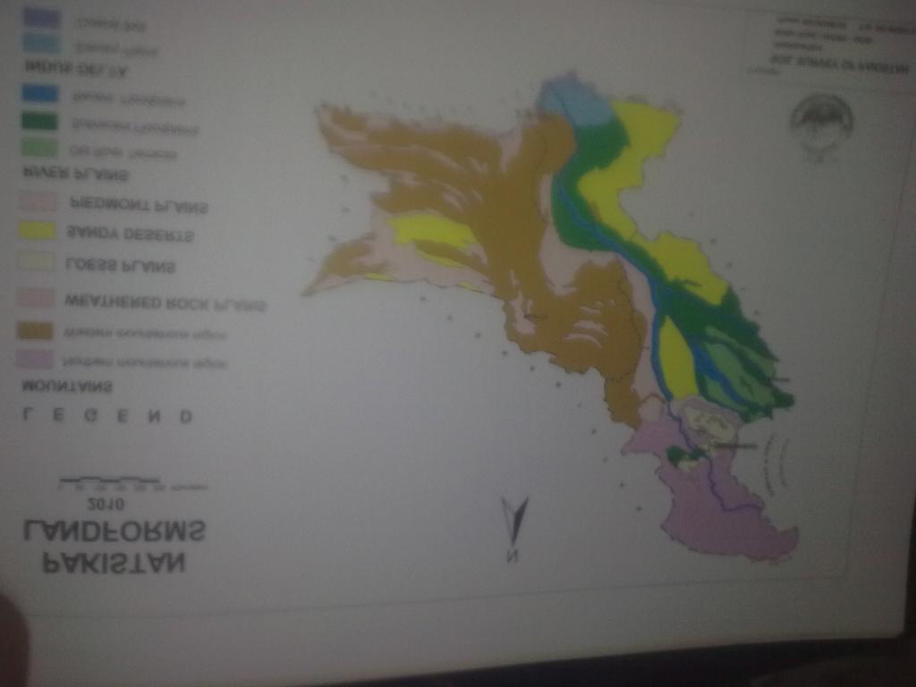
4 Geographically Pakistan has a highly diversified Landscape and environment. Lofty snow covered mountains, Vast Sandy deserts, and extensive river and piedmont plains have contributed to give rise to a country reflecting remarkable variations in soil characteristics. Six major landscapes namely, mountains, Rock plains, Aeolian plains (Loess plains and Sandy deserts), Piedmont plains, River plains and Indus Delta are known to occur in the country.
5 THE SOIL SURVEY OF PAKISTAN: The Soil Survey of Pakistan (SSP) came into being in 1962 as a project titled Soil Survey Project of Pakistan under the Ministry of Food and Agriculture, Govt. of Pakistan. The project was assisted by the United Nations Special Fund (UNDP) with Food and Agriculture Organization (FAO) of the United Nations as its executing agency. The project was regularized as a department in July, Main objective of the project were:
6 Main objectives: To prepare an inventory of Pakistan s s soil resources through standard reconnaissance soil surveys, in the form of reports and maps, which would assist the government in planning of projects aiming at new land development, irrigation extension, drainage improvement, land reclamation, soil conservation, forestry development, watershed management and range improvement, etc., and an overall economic development of the country.
7 Through the Soil Survey Project of Pakistan, in total 27 reconnaissance Soil Survey reports and analog maps were prepared and covered 38% of the area. The report completed up to 1973 are listed below: SR. NO. TITLE OF REPORT SR. NO. TITLE OF REPORT 1 Sheikhupura Area Dera Ismail Khan Lahore District Jacobabad Jhang Area Badin Sahiwal District Ghotki Thal North Muzaffargarh Thal South Hderabad Thatta East Khairpur Sargodha 1966, 2nd Edition Campbellpur Multan South Bahawalnagar Area Multan North Bahawalpur Area 1971
8 SR. NO. TITLE OF REPORT SR. NO. TITLE OF REPORT 21 Sanghar Area Jacobabad-Usta Muhammad Nawabshah Dadu District Larkana Peshawar Vale 24 Rahim Yar Khan 1972 (Peshawar and Mardan District) nd Edition 1973
9 After regularization (1973) of Department, Soil Survey of Pakistan, completed 43 reports and covered 96% of the country s s area. The reports completed are: 28 Cholistan Karachi District Buner Valley Gujranwala Area (Gujranwala and Sialkot Districts) 1968 Reprint Dera Ghazi Khan Lyallpur Area (Sandal Bar and Kamalia Plain), 1967, Reprint Lasbela District Rawalpindi Area 1967, Reprint 1978
10 SR. NO. TITLE OF REPORT SR. NO. TITLE OF REPORT 36 Gujrat District 1967, Reprint Swat Catchment Quetta and Pishin Districts 46 Swat Catchment Salt Range Loralai Haro Basin Zhob Area Dir Upper Thal Kohat Kachhi Tarbela Watershed Kohistan Mahal Murree-Kahuta Kohlu Kalat Sibi Thatta West Kachhi (Evaluation & Utilization) 1990
11 SR. NO. TITLE OF REPORT SR. NO. TITLE OF REPORT 56 Khuzdar Kasur FATA North Thar (South) Gujranwala 66 Narowal 2005 (Updated) Chitral Turbat Kaghan Azad Jamu Kashmir Chilas Panjgur Chagai and Kharan 70 Baltistan (in press) Districts Gwardar Area 1994

12 Semi Detailed and Detailed survey
13 PROVINCE WISE GEOGRAPHICAL AREA AND COVERAGE OF RECONNAISSANCE SOIL SURVEY OF PAKISTAN RECONNAISSANCE SOIL SURVEYS: PROVINCE-WISE COVERAGE Province Geographical Area Area Surveyed Un-surveyed Area ( 000 square kilometers) ( 000 square kilometers) (% of total) ( 000 square kilometers) Punjab 206* Sindh (Thar North) Khyber (South Pakhtunkhwa Wazristan) ) 3.7 (KPK) & FATA (Gaps) Balochistan Gilgit ** 100 Baltistan (GB) Azad Kashmir (AJK) Total Source: Soil Survey of Pakistan, Lahore. 2010
14 Land use Categories of Pakistan (000 ha) Except Gilgit Baltistan LAND USE TYPE AREA %AGE 1. Agriculture 21, Rangelands 25, Coniferous Forests 1, Irrigated Plantations Scrub Forests Riverain Forests Wastelands including areas under 28, Ice and Snow 8. Water Bodies (rivers only) 1, Others TOTAL: 79,
15 LAND CAPABILITY CLASSIFICATION (Thousands hectares) province Class/ Pakistan % Sub-class KPK + Baloch- Punjab Sindh GB AJK FATA istan I II III IV V VI VII 4, , , , VIII Total Classified
16 The Soils of Pakistan identified and classified as : Orders : 06 (Alfisol, Aridisol, Entisol, Inceptisol, Molisol, vertisol) Suborder : 21. great group : 38. Sub group : 112. Families : 353. Soil Series : 894.
17 Area affected by Erosion Water erosion: Degree of Province (area in hectares Pakistan erosion Punjab Sindh KPK+ Baluchista G.B FATA n Slight, (Sheet and Rill) Moderate Sheet and Rill) Severe (Rill, Gully & or steam bank ) Very sever (gully, pipe & pinnacle ) Total
18 Wind Erosion DEGREE OF PROVINCE PAKISTAN EROSION (AREA IN HECTARES PUNJA B SINDH KPK+ FATA BALUCHIST AN G.B Slight, Moderate Severe to very severe 0 8 Total
19 DEGREE OF EROSION Surface patchy Soils affected by salinity and sodicity PROVINCE (AREA IN HECTARES PAKISTAN PUNJAB SINDH KPK+ FATA BALUCHISTAN Irrigated G.B Un irrigated Gypsiferous Saline sodic Irrigated Un irrigated Porous saline sodic Irrigated Un irrigated Dense saline sodic Irrigated Un irrigated Total
20 TRANSFER OF TECHNOLOGY: Through Trainings of 1000s of Extension Workers, Forest officers/ officials, Students, regarding, management of Soils, Selection of soil for specific crop, keeping in view the Soil Type, Climate, Limitation Factors, depth of Soil, Relief, Erosion, drainage / infiltration, aeration / pore spaces, water logging, Salinity / sodicity management, etc
21 UP DATION OF THE DATA AND DIGITIZATION: THE WORK WAS STARTED FROM THE WORK IS IN PROGRESS, THE DETAIL OF COMPLETED WORK IS GIVEN AS UNDER : Updation of Land resource Inventory / Land Evaluation through field surveys. Of 126 Districts of Pakistan and prepare updated reports digitized, Land Form and soil map, present land Use, Land suitability, Land Capability, maps at District, Provincial and country level.
22 The six land forms are: 1.Mountains ; Northern and Western 2.Weathered rock plains. 3.Loess plains. 4.Sandy Deserts. 5.Piedmont plains. 6.River plains: Old river terraces, Sub-recent flood plains, and Recent flood plains. 7.Indus Delta
23
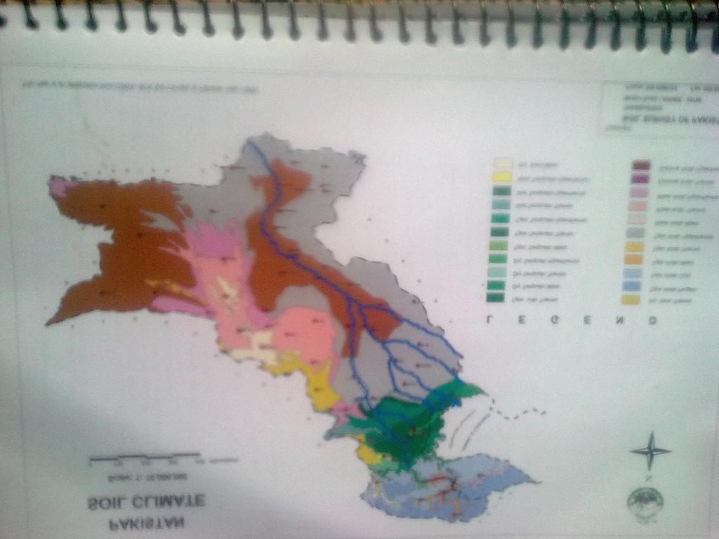
24 Soil Climate: a soil climate map of Pakistan has been produced on the basis of available meteorological data and field experience. In all 04 moisture regime and five soil temperature regimes have been recognized as defined in soil taxonomy. 22 soil climatic regimes resulting from grouping pertinent soil moisture and temperature regimes on accompanying map of Pakistan at 1:10,000,000 scale.
25 The geographic area delineation representing various soils climatic regimes have been based on a mathematical model (Newhall, 1972). The calculation s (Van Wambeke, 1985; SCS-USDA, 1990) are supplemented by our own field experience (Soil Survey staff-ssp, 1965 to 1994)
26
27 Up to date soil series identified are 894 but Generally the soils are categorized in 25 types of soils. The Generalized soil map at 1: 24,000 is given for soil complexes. The dissimilar components are not more than 25%.

28
29 THE DISTRICT WISE UP-DATION AND DIGITIZATION To be covered Total Districts Punjab province Other provinces Covered But unfortunately the organization is devolved to province of Punjab.Thus now the remaining Districts in Punjab will be covered. But this organization Will not continue work for other provinces. Still the provinces or Federal Government has not established any unit for this work.
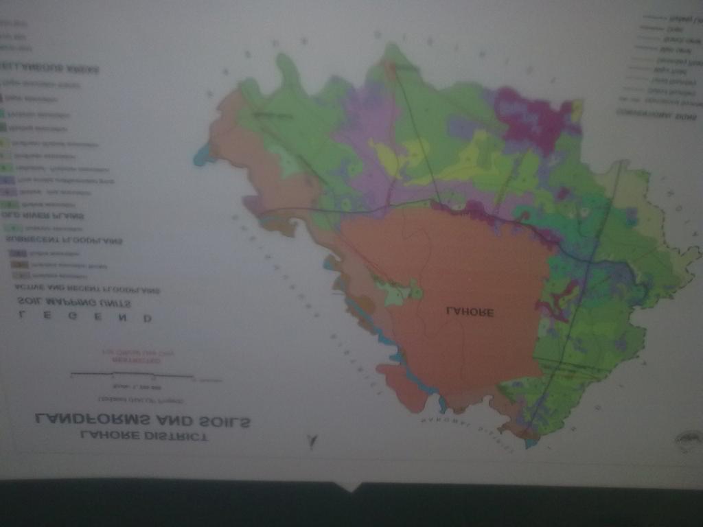
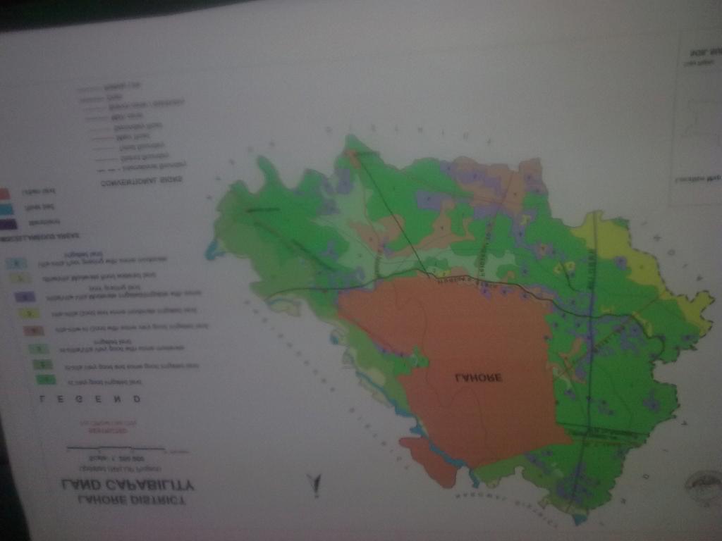
30 In those District wise reports, 04 maps are prepared as, Land forms and Soils, Present land use, Land Suitability, and Land Capability. The reports covers and Describes: 1.Introducion / general Nature of Soil. 2. Present land use. 3. Land Suitability. 4. Land Capability. 5. Management Factors. Maps are given for example:
31

32

33
34
35 Impact Impact of Soil Survey reports, maps The scientific base for resource based land use planning to rationalize agriculture Land use and maximize agriculture production through adoption of appropriate management technology and systematic development / improvement of agriculture land resources. And optimum utilization of land use.
36 Impact on some major Crops is given as under: No doubt there is contribution of other Research organizations along with soil Survey, identification of soil types and management practices suggested as per soil characteristics. The area and production is Increased. The detail of comparison is given in following Table. Crop Area million ha. Production million Tonnes Area million ha. Production Million Wheat Cotton ( Lint Prod '000' bales* of 375 lbs each) Sugar cane Onion Chillies Pulses Maize Rapeseed and mustard All Vegetables Million Tonnes
37 Thanks
38 ORDER SUB ORDER NUMBERS FAMILIES Alfisoils Aridisol s Entisols inceptisol Molisols Vertisois SERIES Total =
39 Land Capability Classification Class/ (Thousands hectares) KPK + Baloch- Sub-class Punjab Sindh GB AJK FATA istan Pakistan % I II III IV V VI VII 4, , , , VIII Sub Total Unclassifie d Grand Total