Community Wildfire Protection Plan An Action Plan for Wildfire Mitigation and Conservation of Natural Resources. Bacon County A U G U S T 1 2,
|
|
|
- Francine Potter
- 5 years ago
- Views:
Transcription


1 A Program of the Georgia Forestry Commission with support from the U.S. Forest Service Community Wildfire Protection Plan An Action Plan for Wildfire Mitigation and Conservation of Natural Resources Bacon County A U G U S T 1 2,
2 Prepared by; Pete Rewis, Chief Ranger Bacon County Will Fell CWPP Specialist Georgia Forestry Commission 1238 GA Hwy 32 East Alma, GA The following report is a collaborative effort among various entities. The representatives listed below comprise the core decision-making team responsible for this report and mutually agree on the plan s contents: Roger Boatright Chairman Bacon County Board of Commissioners Robert S Taylor Alma Bacon County Fire Chief Pete Rewis Chief Ranger, Bacon County Forestry Unit Rhonda Johnson Bacon County EMA Director Wendell Taylor Bennett Still District Fire Chief Art Cothern New Lacy District Fire Chief Louis Martinez Sessoms District Fire Chief Jerry Taylor Taylortown District Fire Chief Billy Tatum Ware District Fire Chief Roger Varnadore Warnock District Fire Chief
3 PLAN CONTENTS I. Objectives... 1 II. Community Collaboration... 1 III. Community Background and Existing Situation... 2 IV. Community Base Map... 4 V. Community Wildfire Risk Assessment... 5 VI. Community Hazards Map... 7 VII. Prioritized Mitigation Recommendations VIII. Action Plan IX. Appendix: Wildfire Pre-Suppression Plan....18
4 I. OBJECTIVES The mission of the following report is to set clear priorities for the implementation of wildfire mitigation in Bacon County. The plan includes prioritized recommendations for the appropriate types and methods of fuel reduction and structure ignitability reduction that will protect this community and its essential infrastructure. It also includes a plan for wildfire suppression. Specifically, the plan includes community-centered actions that will: Educate citizens on wildfire, its risks, and ways to protect lives and properties, Support fire rescue and suppression entities, Focus on collaborative decision-making and citizen participation, Develop and implement effective mitigation strategies, and Develop and implement effective community ordinances and codes. II. COMMUNITY COLLABORATION The core team convened in February of 2009 to assess risks and develop the Community Wildfire Protection Plan. The group is comprised of representatives from local government, local fire authorities, and the state agency responsible for forest management. Below are the groups included in the task force: Bacon County Government Fire Rescue Emergency Management Board of County Commissioners Georgia Forestry Commission GEMA It was decided to conduct community assessments on the basis of the individual fire districts in the county. The chiefs of the six fire departments in the county assessed their districts and reconvened in March for the purpose of completing the following: Risk Assessment Fuels Reduction Structure Ignitability Assessed wildfire hazard risks and prioritized mitigation actions. Identified strategies for coordinating fuels treatment projects. Identified strategies for reducing the ignitability of structures within the Wildland interface. Emergency Management Forged relationships among local government and fire districts and developed/refined a pre-suppression plan. Education and Outreach Developed strategies for increasing citizen awareness and action and to conduct homeowner and community leader workshops. P a g e 1
5 III. COMMUNITY BACKGROUND AND EXISTING SITUATION Background Bacon County, in southeast Georgia, was named for U.S. senator Augustus Octavius Bacon, who served four terms and was president pro tempore of the Senate in The 285-square-mile county was created from portions of Appling, Pierce, and Ware counties in Because Bacon was the 151st county, an amendment was needed to override a previous limit of 145 counties set by Georgia voters in The area, part of the wiregrass region, was first settled by Creek Indians and then by pioneer families from the Carolinas who sought more affordable land. Naval stores and turpentine were the key industries. The county seat, Alma, was incorporated in The courthouse, built in 1919, still serves residents and was placed on the National Register of Historic Places in Two stories exist about the origin of Alma's name. One, put forth in 1966 by Bernice McCullar in her book This Is Your Georgia and frequently repeated by local residents, is that each letter represents the first letter of four of Georgia's early state capitals, Augusta, Louisville, Milledgeville, and Atlanta. However, another story, recorded by Kenneth Krakow in Georgia Place-Names (1975), is that a Macon salesman, traveling through the unnamed town, offered his wife's name, Alma Sheridan. There are no other incorporated towns in the county, but other communities are Rockingham and Sessoms. The community of Rockingham was named for Rockingham, North Carolina, by settlers who hailed from there. Most employment in Bacon County comes from the manufacturing sector, followed by service jobs and retailing. The county also supports a large blueberry industry. A satellite campus of Okefenokee Technical College opened in Alma in In addition to the courthouse, two other Bacon County buildings are listed on the National Register of Historic Places: the Alma Depot and the Rabinowitz Building on West 11th Street. The depot, added to the register in 1983, is privately owned and used as a warehouse. Other buildings and places of interest include the Old Dixon Hotel and the Camp Ground Methodist Church, dating from the early 1800s. Two wildlife management areas, the Bacon Area and Whitehead Creek Area, allow hunting and, with Bacon County's parks, provide visitors and residents ample opportunity for recreation. Annual events include the Georgia Farm Show in January, the Wild Game Festival in April, the Georgia Blueberry Festival in June, the Guysie Mule Roundup in October, the Lions Club Big Buck Contest in October, and the Christmas Parade. According to the 2000 U.S. census, the population of Bacon County is 10,103 (81.5 percent white, 15.7 percent black, and 3.4 percent Hispanic). (Courtesy New Georgia Encyclopedia) P a g e 2
6 Existing Situation While Bacon County has a significant agricultural presence, about 67% of the land area is still in woodland. With the exception of a few large blocks of industrial timberland in the northeastern portion of the county, there are homes scattered throughout the county. With significant tracts of woodlands intermixed with agriculture in the 285 square miles of land in the county, the risk from the wildland urban interface is fairly substantial and general throughout the county. Alma and Bacon County are protected by the Alma - Bacon County Fire Department with the central station located in downtown Alma, with six rural departments well spaced throughout the county. The Georgia Forestry Commission maintains a county protection unit located just east of Alma to respond to wildland fires within the county. The city of Alma is serviced with a modern pressurized water system with hydrants throughout the city and in the industrial area just west of the city. The unincorporated areas have a well spaced system of 32 dry hydrants installed throughout the county. Over the past fifty years, Bacon County has averaged 65 reported wildland fires per year and almost 55% of these have occurred during the months of December, January, February, March and April. These fires have burned an average of 403 acres annually. Of this annual acreage burned, 63% was lost during the months of February, March, April and May. Despite the advent of the outdoor burning permit law about 20 years ago, the numbers of fires have remained steady over the years as more residences have moved out of town into the Wildland Urban Interface. The leading causes of these fires, was debris burning causing 44% of the fires and 40% of the acres burned. Incendiary or arson was the next leading cause with 21% of the fires and 24% of the acres lost. More detailed records over the past five years show that 50% of these debris fires originated from escapes from household or residential debris burning. Georgia Forestry Commission wildfire records show that in the past five years, 109 homes have been lost or damaged by wildfire in Bacon County resulting in estimated losses of $1,695,175 along with 20 outbuildings valued at $19,100. According to reports during this period 66 homes have been directly or indirectly threatened by these fires. Additionally 54 vehicles valued at $473,654 and 12 pieces of other mechanized equipment suffered damages estimated at $884,200. This is a substantial loss of non timber property attributed to wildfires in Bacon County. P a g e 3

7 IV. COMMUNITY BASE MAP P a g e 4
8 V. COMMUNITY WILDFIRE RISK ASSESSMENT The Wildland-Urban Interface There are many definitions of the Wildland-Urban Interface (WUI), however from a fire management perspective it is commonly defined as an area where structures and other human development meet or intermingles with undeveloped wildland or vegetative fuels. As fire is dependent on a certain set of conditions, the National Wildfire Coordinating Group has defined the wildland-urban interface as a set of conditions that exists in or near areas of wildland fuels, regardless of ownership. This set of conditions includes type of vegetation, building construction, accessibility, lot size, topography and other factors such as weather and humidity. When these conditions are present in certain combinations, they make some communities more vulnerable to wildfire damage than others. This set of conditions method is perhaps the best way to define wildland-urban interface areas when planning for wildfire prevention, mitigation, and protection activities. There are three major categories of wildland-urban interface. Depending on the set of conditions present, any of these areas may be at risk from wildfire. A wildfire risk assessment can determine the level of risk. 1. Boundary wildland-urban interface is characterized by areas of development where homes, especially new subdivisions, press against public and private wildlands, such as private or commercial forest land or public forests or parks. This is the classic type of wildland-urban interface, with a clearly defined boundary between the suburban fringe and the rural countryside. 2. Intermix wildland-urban interface areas are places where improved property and/or structures are scattered and interspersed in wildland areas. These may be isolated rural homes or an area that is just beginning to go through the transition from rural to urban land use. 3. Island wildland-urban interface, also called occluded interface, are areas of wildland within predominately urban or suburban areas. As cities or subdivisions grow, islands of undeveloped land may remain, creating remnant forests. Sometimes these remnants exist as parks, or as land that cannot be developed due to site limitations, such as wetlands. (courtesy Fire Ecology and Wildfire Mitigation in Florida 2004) P a g e 5
9 The wildland fire risk assessments conducted in 2009 by the Alma Bacon County Fire Department returned an average score of 136, placing Bacon County in the high hazard range. The risk assessment instrument used to evaluate wildfire hazards to Bacon County s WUI was the Woodland Community Wildfire Hazard Risk Assessment Checklist. The instrument takes into consideration accessibility, vegetation (based on fuel models), topography, roofing assembly, building construction, and availability of fire protection resources, placement of gas and electric utilities, and additional rating factors. The following factors contributed to the wildfire hazard score for Bacon County: Dead end roads with inadequate turn arounds Narrow roads without drivable shoulders Long, narrow, and poorly labeled driveways Limited street signs and homes not clearly marked Thick, highly flammable vegetation surrounding many homes Minimal defensible space around structures Homes with wooden siding and roofs with heavy accumulations of vegetative debris No pressurized or non-pressurized water systems available Above ground utilities Large, adjacent areas of forest or wildlands Undeveloped lots comprising half the total lots in many rural communities. High occurrence of wildfires in the several locations Summary of Bacon County Assessment Ratings Fire District Access Site Hazard Bldg Hazard Add Hazards Total Score Hazard Rating City of Alma Low Risk Bennett Still Moderate Risk Taylortown Extreme Risk Ware Extreme Risk New Lacy High Risk Sessoms Extreme Risk Warnock High Risk Average High Risk P a g e 6


10 WILDFIRE PROTECTION PLAN: AN ACTION PLAN FOR WILDFIRE MITIGATION VI. COMMUNITY HAZARDS MAPS Page 7


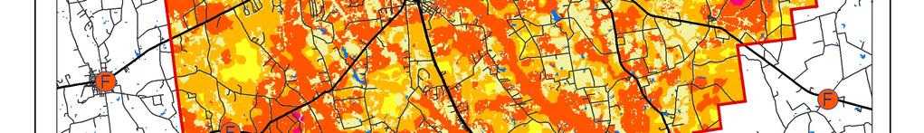

11 WILDFIRE PROTECTION PLAN: AN ACTION PLAN FOR WILDFIRE MITIGATION Page 8


12 WILDFIRE PROTECTION PLAN: AN ACTION PLAN FOR WILDFIRE MITIGATION Page 9
13 VII. PRIORITIZED MITIGATION RECOMMENDATIONS Executive Summary The following recommendations were developed by the Bacon County CWPP Core team as a result of surveying and assessing fuels and structures and by conducting meetings and interviews with county and city officials. A priority order was determined based on which mitigation projects would best reduce the hazard of wildfire in the assessment area. Proposed Community Hazard and Structural Ignitability Reduction Priorities Primary Protection for Community and Its Essential Infrastructure Treatment Area Treatment Types Treatment Method(s) 1. All Structures Create minimum of 30- feet of defensible space** 2. Applicable Structures Reduce structural ignitability** 3. Community Clean-up Day Cutting, mowing, pruning** Trim shrubs and vines to 30 feet from structures, trim overhanging limbs, replace flammable plants near homes with less flammable varieties, remove vegetation around chimneys. Clean flammable vegetative material from roofs and gutters, store firewood appropriately, install skirting around raised structures, store water hoses for ready access, replace pine straw and mulch around plantings with less flammable landscaping materials. Cut, prune, and mow vegetation in shared community spaces. 4. Driveway Access Culvert installation See that adequate lengths of culverts are installed to allow emergency vehicle access. 5. Road Access Identify needed road improvements 6. Codes and Ordinances Examine existing codes and ordinances. As roads are upgraded, widen to minimum standards with at least 50 foot diameter cul de sacs. Amend and enforce existing building codes as they relate to skirting, propane tank locations, public nuisances (trash/debris on property), Property address marking standards and other relevant concerns At such time as the development of zoning, planning and subdivision ordinances become practical include fire department and emergency services input in the design of these. P a g e 1 0
14 Proposed Community Wildland Fuel Reduction Priorities Treatment Area Treatment Types Treatment Method(s) 1. Adjacent WUI Lands Reduce hazardous fuels 2. Railroad Corridors Reduce hazardous fuels Encourage prescribed burning for private landowners and industrial timberlands particularly adjacent to residential areas Encourage railroads to better maintain their ROW eliminating brush and grass through herbicide and mowing. Maintain firebreaks along ROW adjacent to residential areas. 3. Existing Fire Lines Reduce hazardous fuels Clean and re-harrow existing lines. Proposed Improved Community Wildland Fire Response Priorities 1. Water Sources Dry Hydrants Inspect, maintain and improve access to existing dry hydrants. Add signage along road to mark the hydrants 2. Fire Stations Water Tanks Install elevated drop tanks with automatic cut-off valves for quick refilling of trucks 3. Fire Stations Equipment Wildland hand tools. Lightweight Wildland PPE Gear. Larger capacity hose. Investigate need for brush trucks. 4. Emergency infrastructure Equipment Obtain mobile generator to provide backup power where needed. 5. Water Sources Drafting equipment Investigate need for drafting fittings for area irrigation wells. 6. Personnel Training Obtain Wildland Fire Suppression training for Fire Personnel. **Actions to be taken by homeowners and community stakeholders P a g e 1 1
15 Proposed Education and Outreach Priorities 1. Conduct How to Have a Firewise Home Workshop for Bacon County Residents Set up and conduct a workshop for homeowners that teach the principles of making homes and properties safe from wildfire. Topics for discussion include defensible space, landscaping, building construction, etc. Workshop will be scheduled for evenings or weekends when most homeowners are available and advertised through local media outlets. Distribute materials promoting firewise practices and planning through local community and governmental meetings. 2. Conduct Firewise Workshop for Community Leaders Arrange for GFC Firewise program to work with local community leaders and governmental officials on the importance of Firewise Planning in developing ordinances and codes as the county as the need arises. Identify Communities at Risk within the county for possible firewise community recognition. 3. Spring Clean-up Event Conduct clean-up event every spring involving the Georgia Forestry Commission, Alma Bacon County Fire and Rescue and community residents. Set up information table with educational materials and refreshments. Initiate the event with a morning briefing by GFC Firewise coordinator and local fire officials detailing plans for the day and safety precautions. Activities to include the following: Clean flammable vegetative material from roofs and gutters Trim shrubs and vines to 30 feet away from structures Trim overhanging limbs Clean hazardous or flammable debris from adjacent properties Celebrate the work with a community cookout, with Community officials, GFC and Alma Bacon Fire and Rescue discussing and commending the work accomplished. 4. Informational Packets Develop and distribute informational packets to be distributed by realtors and insurance agents. Included in the packets are the following: Be Firewise Around Your Home Firewise Guide to Landscape and Construction Firewise Communities USA Bookmarks P a g e 1 2
16 5. Wildfire Protection Display Create and exhibit a display for the general public at the Georgia Blueberry Festival. The Festival usually runs in June. Display can be independent or combined with the Georgia Forestry Commission display. 6. Press Invite the Alma Times and the Waycross Journal Herald to community Firewise functions for news coverage and regularly submit press releases documenting wildfire risk improvements in Bacon County. P a g e 1 3
17 VIII. ACTION PLAN Roles and Responsibilities The following roles and responsibilities have been developed to implement the action plan: Role Responsibility Hazardous Fuels and Structural Ignitability Reduction Bacon County WUI Fire Council Key Messages to focus on Create this informal team or council comprised of residents, GFC officials, Alma Bacon Fire and Rescue officials, a representative from the city and county government and the EMA Director for Bacon county. Meet periodically to review progress towards mitigation goals, appoint and delegate special activities, work with federal, state, and local officials to assess progress and develop future goals and action plans. Work with residents to implement projects and firewise activities. 1 Defensible Space and Firewise Landscaping 2 Debris Burning Safety 3 Firewise information for homeowners 4 Prescribed burning benefits Communications objectives Target Audiences Methods 1 Create public awareness for fire danger and defensible space issues 2 Identify most significant human cause fire issues 3 Enlist public support to help prevent these causes 4 Encourage people to employ fire prevention and defensible spaces in their communities. 1 Homeowners 2 Forest Landowners and users 3 Civic Groups 4 School Groups 1 News Releases 2 Personal Contacts 3 Key messages and prevention tips 4 Visuals such as signs, brochures and posters P a g e 1 4
18 Spring Clean-up Day Event Coordinator Event Treasurer Publicity Coordinator Work Supervisor Coordinate day s events and schedule, catering for cookout, guest attendance, and moderate activities the day of the day of the event. Collect funds from residents to cover food, equipment rentals, and supplies. Advertise event through neighborhood newsletter, letters to officials, and public service announcements (PSAs) for local media outlets. Publicize post-event through local paper and radio PSAs. Develop volunteer labor force of community residents, develop labor/advisory force from Georgia Forestry Commission, Alma Bacon Fire and Rescue, and Emergency Management Agency. Procure needed equipment and supplies. In cooperation with local city and county officials, develop safety protocol. Supervise work and monitor activities for safety the day of the event. Funding Needs The following funding is needed to implement the action plan: Project Estimated Cost Potential Funding Source(s) 1. Create a minimum of 30 feet of defensible space around structures 2. Reduce structural ignitability by cleaning flammable vegetation from roofs and gutters, appropriately storing firewood, installing skirting around raised structures, storing water hoses for ready access, replacing pine needles and mulch around plantings with less flammable material. 3. Amend codes and ordinances to provide better driveway access, increased visibility of house numbers, properly stored firewood, minimum defensible space brush clearance, required Class A roofing materials and skirting around raised structures, planned maintenance of community lots. Varies Varies No Cost Residents will supply labor and fund required work on their own properties. Residents will supply labor and fund required work on their own properties. To be adopted by city and county government. 4. Spring Cleanup Day Varies Community Business Donations. 5. Fuel Reduction Activities $15 / acre FEMA & USFS Grants P a g e 1 5
19 POTENTIAL FUNDING SOURCES: As funding is questionable in these times of tight government budgets and economic uncertainty, unconventional means should be identified whereby the need for funding can be reduced or eliminated. Publications / Brochures FIREWISE materials are available for cost of shipping only at Another source of mitigation information can be found at Access to reduced cost or free of charge copy services should be sought whereby publications can be reproduced. Free of charge public meeting areas should be identified where communities could gather to be educated regarding prevention and firewise principles. Mitigation Community Protection Grant: o USFS sponsored prescribed burn program. Communities with at risk properties that lie within 3 miles of the USFS border may apply with the GFC to have their forest land prescribed burned free of charge. FEMA Mitigation Policy MRR : through GEMA - Hazard Mitigation Grant Program (HMGP) and Pre Disaster Mitigation (PDM) o o o To provide technical and financial assistance to local governments to assist in the implementation of long term cost effective hazard mitigation measures. This policy addresses wildfire mitigation for the purpose of reducing the threat to all-risk structures through creating defensible space, structural protection through the application of ignition resistant construction, and limited hazardous fuels reduction to protect life and property. With a complete and registered plan (addendum to the State plan) counties can apply for premitigation funding. They will also be eligible for HMGP if the county is declared under a wildfire disaster. GFC - Plowing and burning assistance can be provided through the Georgia Forestry Commission as a low cost option for mitigation efforts. Individual Homeowners In most cases of structural protection ultimately falls on the responsibility of the community and the homeowner. They will bear the cost; yet they will reap the benefit from properly implemented mitigation efforts. GEMA Grant - PDM (See above) Ultimately it is our goal to help the communities by identifying the communities threatened with a high risk to wildfire and educate those communities on methods to implement on reducing those risks. P a g e 1 6
20 Assessment Strategy To accurately assess progress and effectiveness for the action plan, the Alma Bacon WUI Fire Council will implement the following: Annual wildfire risk assessment will be conducted to re-assess wildfire hazards and prioritize needed actions. Mitigation efforts that are recurring (such as mowing, burning, and clearing of defensible space) will be incorporated into an annual renewal of the original action plan. Mitigation efforts that could not be funded in the requested year will be incorporated into the annual renewal of the original action plan. Continuing educational and outreach programs will be conducted and assessed for effectiveness. Workshops will be evaluated based on attendance and post surveys that are distributed by mail 1month and 6 months following workshop date. The Alma Bacon WUFP Team will publish an annual report detailing mitigation projects initiated and completed, progress for ongoing actions, funds received, funds spent, and in-kind services utilized. The report will include a state of the community section that critically evaluates mitigation progress and identifies areas for improvement. Recommendations will be incorporated into the annual renewal of the action plan. An annual survey will be distributed to residents soliciting information on individual mitigation efforts on their own property (e.g., defensible space). Responses will be tallied and reviewed at the next Alma Bacon WUIFC meeting. Needed actions will be discussed and delegated. This plan should become a working document that is shared by local, state, and federal agencies that will use it to accomplish common goals. An agreed-upon schedule for meeting to review accomplishments, solve problems, and plan for the future should extend beyond the scope of this plan. Without this follow up this plan will have limited value P a g e 1 7

21 P. O. Box 819Macon, GA GA- TREESGaTrees.org The Georgia Forestry Commission provides leadership, service, and education in the protection and conservation of Georgia s forest resources.an Equal Opportunity Employer and Service Provider P a g e 1 8