Public Notice ISSUED: May 20, 2016 EXPIRES: June 20, 2016
|
|
|
- Terence Lindsey
- 5 years ago
- Views:
Transcription

1 SPONSOR: Howard Pender Public Notice ISSUED: May 20, 2016 EXPIRES: June 20, 2016 REFER TO: LSP SECTION: Clean Water Act 1. WETLAND COMPENSATORY MITIGATION BANK PROPOSAL 2. SPECIFIC INFORMATION. SPONSOR S ADDRESS: SPONSOR S AGENT: Howard Pender Jr Dorff Beach Road Audubon, Minnesota Mark Aanenson Houston Engineering st Avenue North Fargo, North Dakota PROJECT LOCATION: The project site is located in SW ¼, Section 16, T138N, R45W, Clay County, Minnesota. The approximate UTM coordinates are N , E Latitude Longitude BANK SERVICE AREA: The proposed bank service area is Upper Red River of the North (Bank Service Area 4). DESCRIPTION OF PROJECT: The sponsor is proposing to develop the Howard Pender Wetland Bank by ceasing farming activities on portions of the property that have been historically tilled and planting these areas with native vegetation. The conservation easement for this bank will contain approximately acres. Within the conservation easement, approximately acres of farmed wetland and upland buffer will be vegetatively enhanced and given partial wetland bank credits (ie approximately 33% - 50% according to district wetland bank policy). The remaining acres within the easement area consists of existing wetlands and forested areas and will not be given wetland bank credits, however these areas will be contained within the conservation easement. Current land use, including adjacent properties The proposed wetland bank is located in a rural portion of southeastern Clay County, Minnesota. Information supplied with the prospectus indicates that the property has been in nearly continuous agricultural crop production since the early 1900 s. Wetlands within the parcel have been tilled or otherwise utilized for agricultural operations when conditions allowed. Adjacent properties are primarily large to medium sized agricultural operations producing primarily row crops. There is a small homesteads on the property. Rural residences are found on adjacent properties. Modifications proposed to restore, establish, enhance and/or preserve wetlands on the bank site The total amount of property included in the easement will be acres comprising permanent wetlands, tilled and cropped wetland and tilled upland areas.
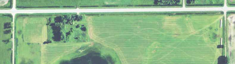
2 Operations - Regulatory ( LSP) The consultant conducted a review of aerial photography, LIDAR and soil data to evaluate the potential for vegetative enhancement of cropped wetlands at the site. 13 currently tilled and cropped basins were identified as having the appropriate soils and topography that could potentially be enhanced by planting to native vegetation. These 13 basins are all currently in crop production. The potential enhancement locations are shown on the attached map labeled LSP Page 3 of 3. These wetland basins will be planted with a native seed mix appropriate for the site. A large, shallow marsh exists near the center of the easement, but will not be given wetland bank credits. The upland portions of the easement will be planted with an appropriate native seed mix and will be credited based upon meeting success criteria in accordance with district wetland bank policy. Long-term management of the site: The applicant has proposed to place a perpetual conservation easement on acres of the site as shown on the attached drawing labeled LSP Page 2 of 3. All agricultural activities will cease within the easement boundary and it will be maintained as a native plant community in perpetuity. The project would restore approximately 33.91acres of wetlands with an additional acres of upland. Crediting will be based upon the current Saint Paul district wetland bank policy from SURROUNDING LAND USE: This bank site is located in a rural area of Clay County. This area is dominated by large and medium sized agricultural operations primarily growing row crops such as corn and soybeans. COORDINATION WITH RESOURCE AGENCIES: This project has been coordinated with the following members of the Interagency Review Team (IRT) and other resource agencies: United States Fish and Wildlife Service, United States Environmental Protection Agency, Minnesota Department of Natural Resources, Minnesota Board of Water and Soil Resources. 3. REPLIES/COMMENTS. Interested parties are invited to submit to this office written facts, arguments, or objections within 30 days of the date of this notice. These statements should bear upon the suitability of the location and the adequacy of the project and should, if appropriate, suggest any changes believed to be desirable. Comments received may be forwarded to the applicant. A copy of the full prospectus submitted by the Sponsor is available to the public for review upon request. Replies may be addressed to Regulatory Branch, St. Paul District, Corps of Engineers, 4111 Technology Drive NW, Bemidji, Minnesota, Attn: Larry Puchalski. Or, IF YOU HAVE QUESTIONS ABOUT THE PROJECT, call Larry Puchalski at the Bemidji Regulatory Field Office of the Corps, telephone number (651) To receive Public Notices by , go to: and add your information in the New Registration Box. 2
3 Operations - Regulatory ( LSP) 4. FEDERALLY-LISTED THREATENED OR ENDANGERED WILDLIFE OR PLANTS OR THEIR CRITICAL HABITAT. None were identified by the bank sponsor or are known to exist in the action area. However, Clay County is within the known historic range for the following Federally-listed species: Northern Long-Eared Bat Northern Prairie Fringed Orchid Dakota Skipper Poweshiek Skipperling Hibernates in caves and mines swarming in surrounding wooded areas in autumn. Roosts and forages in upland forests during spring and summer. Native mesic prairie habitat. Native prairie habitat. Native prairie habitat. This notice is being coordinated with the U.S. Fish and Wildlife Service. Any comments it may have concerning Federally-listed threatened or endangered wildlife or plants or their critical habitat will be considered in our final assessment of the described work. 5. JURISDICTION. The aquatic resources, if any, within the boundaries of the proposed mitigation bank are being reviewed in accordance with current practices for documenting Corps jurisdiction under Section(s) 9 & 10 of the Rivers and Harbor Act of 1899 and Section 404 of the Clean Water Act. We have made a preliminary determination that the aquatic resources within the boundaries of the proposed mitigation bank are subject to Corps of Engineers jurisdiction under Section(s) 9 & 10 of the Rivers and Harbors Act of 1899 and/or Section 404 of the Clean Water Act. If an approved jurisdictional determination is completed for this mitigation bank, a copy will be posted on the St. Paul District web page at the following link: Any regulated discharges associated with implementation of a final approved bank plan could likely be authorized by regional general permit if the bank plan is approved before any regulated discharge occurs. Any required compensatory mitigation would be accounted for in the credit yield calculations because this is a mitigation bank project. 6. HISTORICAL/ARCHAEOLOGICAL. The Corps will review information on known cultural resources and/or historic properties within and adjacent to the project area. The Corps will also consider the potential effects of the project on any properties that have yet to be identified. The results of this review and the Corps determination of effect will be coordinated with the State Historic Preservation Officer independent of this public notice. Any adverse effects on historic properties will be resolved prior to the Corps authorization, or approval, of the work in connection with this project. 3
4 Operations - Regulatory ( LSP) 7. PUBLIC HEARING REQUESTS. Any person may request, in writing, within the comment period specified in this notice, that a public hearing be held to consider this application. Requests for public hearings shall state, in detail, the reasons for holding a public hearing. A request may be denied if substantive reasons for holding a hearing are not provided or if there is otherwise no valid interest to be served. Enclosure(s) Chad S. Konickson Chief, Regulatory Branch 4


5 ST Riverton LSP Page 1 of 3 Hawley ST 12 Eglon ± ST 71 ST 10 Project Location Elkton Clay County Skree ST 120 ST 119 ST 121 Parke?A@ 32 ST 124 ST ST ST ST H:\Fargo\JBN\7000\7031\14_7031_002\GIS\Project Location.mxd ST 52 ST Barnesville ST 55 ST 55 ST 51 ST 2?A@ ST Barnesville Miles Atherton ST 52 Prairie View Humboldt Wilkin County ?A@ ST 127 Pender Wetland Banking Project Location Tansem Scale: Drawn by: Checked by: Project No : Date: Sheet: AS SHOWN SMO ZOH /25/ of 1


6 200TH ST S LSP Page 2 of 3 ± 16 Skree Clay County H:\Fargo\JBN\7000\7031\14_7031_002\GIS\Site Maps.mxd ST NAIP Image Project Boundary ST 10 90TH AVE S Feet Pender Wetland Banking Project Boundaries Scale: Drawn by: Checked by: Project No : Date: Sheet: AS SHOWN SMO ZOH /25/ of 1 205TH ST S


7 LSP Page 3 of 3