PROJECT SUMMARY WHAT:
|
|
|
- Imogene Hodges
- 5 years ago
- Views:
Transcription

1
2 PROJECT SUMMARY WHAT: A conservation partnership to identify flood-prone cleared land in the Lower Mississippi River s active floodplain that landowners desire to reforest through Wetland Reserve Easements. WHO: The Mississippi River Trust and the Lower Mississippi River Conservation Committee in partnership with the Natural Resources Conservation Service, the Walton Family Foundation and the U.S. Endowment for Forestry and Communities. WHERE: From the Ohio River confluence to the port of Baton Rouge in six states. The project area covers 2 million acres (near-term goal of 20,000 acres by 2020). WHY: To improve water quality in the river and Gulf of Mexico, increase wildlife habitat, enhance recreational opportunities, save taxpayer expenditures for crop insurance and disaster relief on frequently flooded farmland, and protect navigation and flood control infrastructure.
3 THE MISSISSIPPI RIVER TRUST Operates as a land trust in six states along the Lower Mississippi River. Primary tool is the conservation easement, which allows willing landowners to protect important ecological and historical assets, retain ownership, and prevent land use changes while obtaining tax advantages. Works with governmental and private entities on land conservation, water quality protection and conservation planning issues along the Lower Mississippi River. Works to develop policy for both private and public lands, with an emphasis on policies beneficial to the Lower Mississippi River, such as the Conservation Title of the Farm Bill. Has protected 49,095 acres, restored 21,680 acres and enhanced 23,581 acres, for a total of 94,356 acres throughout the Lower Mississippi River corridor. Founded in 2002.
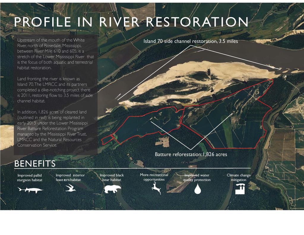
4 PROJECT AREA DESCRIPTION 699-mile reach of the Lower Mississippi River and its active floodplain from the confluence with the Ohio River (River Mile 954) to the upper limit of the Port of Baton Rouge, Louisiana (River Mile 255) Total project area = 2 million acres o Woody/Herbaceous Wetlands = 1,065,335 acres o Open Water = 478,000 acres o Cropland = 345,000 acres o Other Land Uses = 90,375 acres o Other Forest = 21,290 acres Reforestation eliminates annual inputs of nitrogen- and phosphorus-based fertilizers and various pesticides. Batture sequesters nutrients from river. Batture provides wildlife corridors and supports black bears, forest-dwelling songbirds, waterfowl, wading birds, various bats, white-tailed deer, etc.

5 PROJECT STATUS Project now in Phase II. Nearly 15,000 acres closed, pending closure or in application in six states. About half of acres in Tennessee. Phase III application submitted to NRCS in May 2016.
.")
6 PROJECT OPPORTUNITIES Identify areas where reforestation could help protect the navigation channel, mainline levees and other infrastructure. Determine where reforestation could be done in concert with aquatic habitat restoration (e.g. Conservation Reach Study sites). Quantify the value of the batture for nutrient sequestration and other water quality improvements.


7 AVERTING RISKS TO NAVIGATION CHANNEL During the 2011 flood, the river began to form a new cut-off between river miles , near Tiptonville, Tenn. Erosion extended for a distance of 4,000 feet and 80 feet deep. Increased risk to mainline levee without response. Source: Mississippi River Geomorphology and Potamology Program

8 AVERTING RISKS TO NAVIGATION CHANNEL During the 2011 flood, the river began to form a new cut-off between river miles , near Tiptonville, Tenn. Erosion extended for a distance of 4,000 feet and 80 feet deep. Source: Natural Resource Conservation Service Increased risk to mainline levee without response.

9 AVERTING RISKS TO NAVIGATION CHANNEL NRCS has secured 4,455 acres of Wetland Reserve Easements, mostly since More easements are expected. Corps of Engineers considers reforestation long-term risk mitigation. Source: Natural Resource Conservation Service Structural measures taken while trees grow.

10 CONSERVATION REACHES The Lower Mississippi River Resource Assessment identified eight Conservation Reaches. Are there ecological advantages to focusing aquatic and terrestrial restoration projects in these reaches? Are there practical advantages (e.g. channel or levee protection)?

11 Hatchie River-Loosahatchie Reach, river miles Hatchie River mouth downstream to Memphis. Wetland Reserve Easements at northern and southern ends. Extensive cropland in the batture. 17 LMRCC projects identified (dike notching, improve floodplain connectivity, etc.).
12

13 WATER QUALITY Can we quantify the value of the batture for capturing nutrients? What is the per-acre value of converting cleared land in the batture to forested land? Can we offer economic incentives to landowners based on this value? Source: 2016 Hypoxia Forecast
14 QUESTIONS OR COMMENTS