COMMENTS ON THE RELEASE OF LAND FOR DEVELOPMENT ACTIVITIES AND RESETTLEMENT WITHIN THE DISTRICT OF MANNAR 21/07/2017
|
|
|
- Margery Watkins
- 5 years ago
- Views:
Transcription

1 E N V I R O N M E N T A L F O U N D A T I O N ( G U A R A N T E E ) L I M I T E D COMMENTS ON THE RELEASE OF LAND FOR DEVELOPMENT ACTIVITIES AND RESETTLEMENT WITHIN THE DISTRICT OF MANNAR 21/07/2017
2 21 st July, The President, Committee appointed to present Recommendations for the Release of Land for Development Activities within the District of Mannar, Ministry of Provincial Councils and Local Government, No. 330, Union Place, Colombo 02. Dear Sir/Madam, Comments on the release of land for development activities and resettlement within the district of Mannar In response to the newspaper notification that appeared on the above mentioned subject, the Environmental Foundation (Guarantee) Ltd (EFL) hereby forwards comments on the same. EFL s recommendations stated below are based on the report of the Integrated Strategic Environmental Assessment (ISEA) of the Northern Province of Sri Lanka published in the year 2014 by the Central Environmental Authority and the Disaster Management Centre of Sri Lanka as well as on independent research and analysis carried out by EFL. We would like to bring to your notice that, an in-depth analysis of our concerns on meeting the land requirement, could have been carried out, if adequate time was availed by the Committee. Therefore, this documents contains only the generalities on how land alienation should be carried out. Further, please note that the maps incorporated in this document have been produced with the extraction of data from the aforementioned ISEA report. 1. Existing Protected Areas within the district of Mannar and current violations pertaining to these The report of the ISEA of the Northern Province of Sri Lanka only contains data of Protected Areas declared until Therefore, the analysis and recommendations provided in the ISEA report cannot be directly taken into consideration. The latest data on Protected Areas listed below have been acquired from the Forest Department and the Department of Wildlife and the analysis is based on the present Protected Area network within the district. Areas under Forest Department The division of Musali situated to the north of the Wilpattu National Park consists of a collective of forest areas known as the Wilpattu North Forest Complex. These have been declared so, giving due consideration to the ecological importance and the ecosystem services they provide. These forested areas are a major habitat of 2
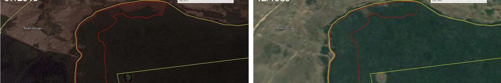
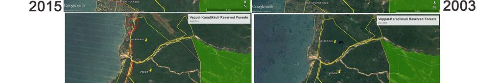
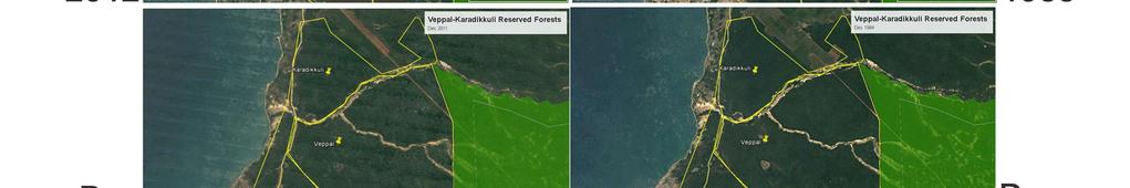
3 the elephants and other bird species and is vastly used by villagers for traditional purposes. Forest Reserve Area/ha Date Gazetted Mavillu 14, * Neenthavil 8, * Veppal 10, * Mullikulam 5, Vilathikulam 2, Periyamurippu 7, Karakdikuli 6, Marichchakaddi Maduroad 44, Pampaidii 3, Vidataltivu Palakaimunai * Even though the protected status of these Forest Reserves were confirmed by the Forest Department, they were unable to share the corresponding Gazette dates. Out of these Forest Reserves, Veppal, Vilaththikulam and Maraichchukkaddi-Karadikkuli have been encroached into, in the form of construction of housing schemes. The progression of deforestation that took place as a result is visible in the images extracted from Google Earth, depicted below. This is a clear violation of the Forest Conservation Ordinance and the images dating back to 1984 indicate that, there haven t been any previous settlements in the areas concerned. Therefore, these high conservation areas identified in the ISEA report itself require to be duly protected from encroachments. These encroachers could be resettled in other areas within the district that do not fall under the Protected Area category. Further, when resettling, it s important that other forested areas are avoided should the ground conditions allow to do so and if otherwise, an Environmental Impact Assessment (EIA) be carried out as per provisions of the National Environment Act, for areas above one hectare, in order to mitigate possible impacts while incorporating development activities. 3


4 4


5 5
6 Areas under the Department of Wildlife Conservation As seen below in the table, the recently declared Protected Areas (in bold type) receive higher protection where human activities are prohibited, except for visitation and research purposes, subject to prior approval from the department. These areas have been declared so, due to the ecosystem diversity and avifauna diversity that is unique to the Mannar district, as described further below in this document. Situated on the Asian Migratory Pathway, environ of the Mannar island is a key entry point of the migrating bird population. Therefore it s imperative that these areas be duly protected as legally prescribed. Protected Area Area/ha Date of Declaration Vedithalativu (Nature Reserve) Adam s Bridge (National Park) Vankellei (Sanctuary) Giant s Tank (Sanctuary) Madu Road (National Park) As these are newly declared areas, there s continuous pressure from human activities and encroachments. Therefore, the local communities residing at the boundaries and buffer zones may have to be made aware of the ecological importance and forbidden activities within such areas. It is advisable to provide them with alternate land, according to availability and priority level based on the sensitivity of the particular area in order to avoid possible conflicts. Since more than 50% of the Mannar district constitutes Gazetted Protected Areas, a proper plan of management for buffer zones is imperative in order to strike a balance between the establishment of settlements and conservation. The map below indicates the Protected Area coverage within the Mannar district except for the Vankellei Sanctuary which approximately cover an area between and including the mainland and the Mannar island. 6


, and invertebrates, such as shrimp. These species utilize sea grass meadows as their feeding grounds and even as nurseries and are thus intrinsic to their survival.")
7 2. Ecological importance of the district The district of Mannar hosts a wide variety of eco regions, both terrestrially and marine coastally. Each of these different habitats play an important role in contributing to Sri Lanka s rich biodiversity. Many of the species in these areas require large areas in order to successfully feed, breed and subsist in, especially species that are not adapted to edge habitat. Three important coastal marine ecosystems found in the Mannar district are mangrove communities, saltmarshes and seagrass beds. Seagrass beds are meadows of sea grass and are home to many different species of fish such as cichlids (Cichlidae), turtles such as the Green sea turtle (Chelonia mydas) and Hawksbill sea turtle (Eretmochelys imbricate), and invertebrates, such as shrimp. These species utilize sea grass meadows as their feeding grounds and even as nurseries and are thus intrinsic to their survival. Mangroves and saltmarsh communities are similar, as they are both intertidal communities. However, they differ in that mangrove communities have taller mangrove trees and saltmarshes are dominated by smaller intertidal herbs. Both of these communities are exposed to extreme conditions such as dry, desiccating and salty conditions and thus both the floral species and faunal species are adapted to the conditions they are subjected to, giving rise to a unique collection of floral and faunal species. The main terrestrial biome in Mannar is the arid zone forest, which, according to differences in edaphic factors can be classified into two types, the dry evergreen thickets and woodlands. Many of the faunal species living in these habitats that need protection require contiguous habitat to feed and breed. Destroyed and fragmented habitat will prevent breeding between individuals of the same species, and thus reduce gene flow amongst 7

, present and rural settlement areas. It is important to note that only a very few previous settlements could be observed within Protected Areas and moderate amount of rural settlements.")

8 them. This will reduce the genetic diversity of the species in these fragments and leave them vulnerable to natural disasters or any anthropogenic forces. The special and diverse assortment of flora and fauna found in this ecosystem are invaluable contributions to the overall species diversity of Sri Lanka. 3. Distribution of settlements According to the data on settlements presented in the ISEA report (that contains data up to 2010 only), they have been categorized into three sections as previous (prior to 1983), present and rural settlement areas. It is important to note that only a very few previous settlements could be observed within Protected Areas and moderate amount of rural settlements. These will have to be suitably relocated within developed areas where settlements are already established. According to the data presented in the ISEA report unoccupied locations remain within the Divisions of Mannar Town, Nanaddan, south of Manthai West and north of Musali for resettlement purposes. Catchment areas at present have not been heavily disturbed by settlements and it is imperative that this situation remains for the upkeep of ecosystem balance and for water security for the people of the district where severe climatic conditions prevail. The annual rainfall being less than 750mm, protection of water sources and watersheds is crucial for the survival of all communities. 8


9 4. Availability of water sources Considering the geographical location of the Mannar district, situated within the arid zone of the country, the Mannar Town division has a high to medium level of ground water quantity as well as surface water bodies i.e. tanks, canals and rivers that would support human and agricultural activities. Further, the National Water Supply and Drainage Board 9


10 has proposed a water supply scheme for Thalaimannar, promoting settlements within the Mannar island. Therefore it is advisable to concentrate townships within these areas, leaving out Gazetted Protected Areas. 5. Impacts of tourism The Mannar district is an under explored haven for tourists due to its potential for various touristic activities that include diving, snorkeling, kitesurfing, windsurfing as well as biodiversity exploration. Apart from such activities the district also comprises several important archaeological sites that would attract tourists. Therefore these resources will have to be sustainably exploited through the practice of ecotourism, promoting ecofriendly infrastructure and increased environmental consciousness within those who are involved in the industry. Release of land for such activities, within Protected Areas cannot happen at any cost and all activities related to tourism will have to be strictly monitored. Even when releasing adjacent land to such areas, it is important that strict regulations be enforced for the benefit of the environment and local communities alike. Tourism potential areas included in the map denote marine/water based touristic activities and agro tourism areas. Most of these potential areas for the establishment of touristic activities are further away from Protected Areas and it s important that this state remains so, for the practice of sustainable tourism and environmental conservation. 10
11