SPECIAL HEARING AGENDA
|
|
|
- Caroline Wheeler
- 5 years ago
- Views:
Transcription
1 SPECIAL HEARING AGENDA PLANNING AND ZONING BOARD -- CITY OF FORT COLLINS Interested persons are invited to attend and be heard at the time and place specified. Please contact the Current Planning Department for further information on any of the agenda items at DATE: Monday, May 6, 013 TIME: 6:00 P.M. PLACE: Council Chambers, City Hall West, 300 LaPorte Avenue, Fort Collins, CO A. Roll Call B. Agenda Review C. Citizen Participation (30 minutes total for non-agenda and pending application topics) D. Consent Agenda: The Consent agenda consists of items with no known opposition or concern and is considered for approval as a group allowing the Planning and Zoning Board to spend its time and energy on the controversial items. Any member of the Board, staff, or audience may request an item be pulled off the Consent Agenda. None E. Discussion Agenda: Specific time for public input has been set aside for discussion on the following items: The Planning and Zoning Board provides a recommendation to City Council on the following items: 1. Midtown Urban Renewal Plan Amendment This is a request for a recommendation to City Council as to whether the amended Midtown Urban Renewal Plan is in conformance with the principles and policies identified in City Plan Applicant: City of Fort Collins Staff: Tom Leeson F. Other Business G. Adjourn
2 PROJECT: APPLICANT: Midtown Urban Renewal Plan Amendment Fort Collins Urban Renewal Authority PROJECT DESCRIPTION: Council authorized staff to initiate an Existing Conditions Survey of the Midtown commercial corridor, the area along South College Avenue from Prospect Road to Fairway Lane. The purpose of the Survey was to document visual and non-visual observations of blight to determine whether Midtown constitutes a blighted area within the meaning of Colorado Urban Renewal Law. In addition to the Midtown Existing Conditions Survey field work, both the Prospect South (008) and Foothills Mall (007) Existing Conditions Surveys were updated in 011 to ensure the findings remain consistent with the original document, and to identify unfavorable conditions that have occurred since the documents were finalized. The Survey was presented to the Planning and Zoning Board (P&Z) and City Council in April, 011. As the Survey shows, seven of the eleven statutory blight factors were found in Midtown, which makes the area eligible for an Urban Renewal Plan (URP) and the use of tax increment financing (TIF) to assist in eliminating blighted conditions. City Council confirmed that sufficient evidence exists to establish a Midtown URP, and directed staff to prepare the Plan document. Before Council can officially approve an amendment to the URP to include the Foothills Tax Increment District, state law requires Council to submit the URP amendment to P&Z for its review and recommendation as to the amended Plan s conformity with the principles and policies identified in City Plan. The following excerpts highlight the linkage between City Plan and the amended URP that P&Z should reference. These are representative excerpts, and not an all-inclusive listing of relevant statements: Principle EH 4: The City will encourage the redevelopment of strategic areas within the community as defined in the Community and Neighborhood Livability and Neighborhood Principles and Policies. Policy EH 4.1: Prioritize Targeted Redevelopment Areas Create and utilize strategies and plans, as described in the Community and Neighborhood Livability and Neighborhood chapter s Infill and Redevelopment section, to support redevelopment areas and prevent areas from becoming blighted. The Targeted Infill and Redevelopment Areas (depicted on Figure LIV 1 in the Community and Neighborhood Livability chapter) shall be a priority for future development, capital investment, and public incentives. Policy EH 4.: Reduce Barriers to Infill Development and Redevelopment
3 Develop new policies and modify current policies, procedures, and practices to reduce and resolve barriers to Infill development and redevelopment. Emphasize new policies and modifications to existing policies that support a sustainable, flexible, and predictable approach to infill development and redevelopment. Policy LIV 5.1: Encourage Targeted Redevelopment and Infill Encourage redevelopment and infill in Activity Centers and Targeted Infill and Redevelopment Areas identified on the Targeted Infill and Redevelopment Areas Map. The purpose of these areas is to: Promote the revitalization of existing, underutilized commercial and industrial areas. Concentrate higher density housing and mixed-use development in locations that are currently or will be served by high frequency transit in the future and that can support higher levels of activity. Channel development where it will be beneficial and can best improve access to jobs, housing, and services with fewer and shorter auto trips. Promote reinvestment in areas where infrastructure already exists. Increase economic activity in the area to benefit existing residents and businesses and, where necessary, provide the stimulus to redevelop. Areas identified on the Targeted Infill and Redevelopment Areas Map are parts of the city where general agreement exists that redevelopment and infill would be beneficial. These areas are generally considered a priority for efforts to reduce barriers and concentrate public investment in infrastructure. However, of the areas identified, the community spine (see Policy LIV 5.) shall be the highest priority location for such efforts. Areas not shown on the Targeted Infill and Redevelopment Areas map are not excluded from redevelopment and infill activity, but are considered to be lower priority or where activity is less likely to occur for other reasons. Policy LIV 5.: Target Public Investment along the Community Spine Together, many of the Targeted Redevelopment Areas and Activity Centers form the community spine of the city along College Avenue and the Mason Corridor. The community spine shall be considered the highest priority area for public investment in streetscape and urban design improvements and other infrastructure upgrades to support infill and redevelopment and to promote the corridor s transition to a series of transit-supportive, mixed-use activity centers over time. Established residential neighborhoods adjacent to College Avenue and the Mason Corridor will be served by improvements to the community spine over time, but are not intended to be targeted for infill or redevelopment. Policy LIV 5.3: Policy LIV 5.3 Identify Additional Redevelopment and Infill Areas as Appropriate Utilize subarea plans to help designate areas for redevelopment and infill that are not identified on the Targeted Infill and Redevelopment Areas Map. Within these plans, support the
4 development of appropriate design standards to protect the character of neighborhoods and to ensure conformance with City Plan. Principle LIV 34: General Commercial Districts will include a wide range of community and regional uses, in various sizes and scales, designed for convenient access by all modes of travel, efficient circulation, and a comfortable pedestrian environment. Policy LIV 34.: Mix of Uses Although many existing General Commercial Districts in the City consist of single-use commercial centers today, the incorporation of a broader mix of uses is desirable over time: Principal uses: Retail, restaurants, office, and other commercial services. Supporting uses: Entertainment, high-density residential, day care (adult and child), and other supporting uses. Policy LIV 34.3: Support the Revitalization of Existing Strip Commercial Corridor Developments Encourage and support the gradual evolution of existing, auto-oriented strip commercial areas to a more compact, pedestrian and transit-oriented pattern of development over time through infill and redevelopment. Establish enhanced walking connections between destinations. Principle LIV 35: Community Commercial Districts will be communitywide destinations and hubs for a high-frequency transit system. They will be quality mixed-use urban activity centers that offer retail, offices, services, small civic uses, and higher density housing, in an environment that promotes walking, bicycling, transit and ridesharing. Policy LIV 35.4: Transform through Infill and Redevelopment Support the transformation of existing, underutilized Community Commercial Districts through infill and redevelopment over time to more intense centers of activity that include a mixture of land uses and activities, an enhanced appearance, and access to all transportation modes. Principle LIV 43: Enhanced Travel Corridors will be strategic and specialized Transportation Corridors that contain amenities and designs that specifically promote walking, the use of mass transit, and bicycling. Enhanced Travel Corridors will provide high-frequency/high efficiency travel opportunities for all modes linking major activity centers and districts in the city. Policy LIV 43.3: Support Transit-Supportive Development Patterns Support the incorporation of higher intensity, transit-supportive development along Enhanced Travel Corridors through infill and redevelopment. Encourage the densities and broader mix of uses necessary to support walking, bicycling, and transit use while accommodating efficient automobile use. After P&Z provides its recommendation, Council will consider adoption of the amended Midtown URP on May 7,
5 ACTION REQUESTED: Recommendation to City Council as to whether the amended Midtown Urban Renewal Plan is in conformance with the principles and policies identified in City Plan. STAFF RECOMMENDATION: The amended Midtown Urban Renewal Plan conforms to the principles and policies identified in City Plan. 4
 Amended: May, 013 to add Tax Increment Financing District-Foothills Mall Prepared By: Fort Collins Urban Renewal Authority")
6 Midtown Urban Renewal Plan Style Definition: DocID Prepared for: City of Fort Collins and Fort Collins Urban Renewal Authority Adopted: September 6, 011 (Including Tax Increment Financing District-Prospect South) Amended: May, 013 to add Tax Increment Financing District-Foothills Mall Prepared By: Fort Collins Urban Renewal Authority
7 This page intentionally left blank.
8 Contents 1. Introduction Blight Conditions Plan Objectives Authorized Urban Renewal Activities Public Improvements and Facilities Cooperative Agreements Purchase of Property Demolition, Clearance, Environmental Remediation, and Site Prep Property Disposition Redevelopment Agreements Relocation Assistance Hiring Legal Authority Catalyst and Enhancement Projects Development Standards and Procedures Conformance Urban Renewal Law City Plan Project Financing Tax Increment Financing (TIF) District Boundaries Property Tax Increment Sales Tax Increment Tax Increment Reimbursement Modifications to the Plan Reasonable Variations Effective Date of the Plan Appendices Appendix A Legal Description DESCRIPTION OF THE AREA Appendix B Legal Description DESCRIPTION OF THE TAX INCREMENT FINANCING DISTRICT PROSPECT SOUTH 83 Appendix C -- Legal Description.4 DESCRIPTION OF THE TAX INCREMENT FINANCING DISTRICT -- FOOTHILLS MALL.4
9 List of Figures Figure 1: Midtown Urban Renewal Plan Boundary Figure : Tax Increment Financing AreaDistrict Prospect South Figure 3. Tax Increment Financing District -- Foothills Mall 8
10 1. Introduction The Midtown Urban Renewal Plan (Plan) is a plan prepared for the Fort Collins Urban Renewal Authority (Authority) and the City of Fort Collins (the City), pursuant to the provisions of the Urban Renewal Law, Colo. Rev. Stat et seq. (Urban Renewal Law). Terms used in the Plan have the same meaning as in the Urban Renewal Law. The jurisdictional boundaries of the Authority are the same as the boundaries of the City. Within the City boundaries there may be one or more urban renewal plan areas. This Plan describes the framework for certain public undertakings constituting urban renewal projects and other authorized activities under the Urban Renewal Law in the Midtown Urban Renewal Plan Area (Plan Area), located in the City of Fort Collins, Larimer County, Colorado. This Plan was prepared for adoption by the City Council in recognition that the Midtown Commercial Corridor requires a coordinated, cooperative strategy, with financing possibilities, to eliminate unfavorable existing conditions and prevent further deterioration. This Plan intends to accomplish the City s development objectives for improving the viability of the commercial corridor by creation of the Plan Area. The driving interest in the establishment of this Plan is to begin offering tax increment financing (TIF) as a tool to stimulate and leverage both public and private sector development (including redevelopment), to help remedy adverse conditions and prevent the spread of further deterioration. It is the intent of this Plan for any development projects and other implementation actions to be done in a responsive manner, with full consideration for interests and concerns of property owners in the Plan Area. Development and redevelopment is anticipated to occur incrementally over a substantial period of time, with the potential for Authority financing to provide the impetus and means to undertake this redevelopment at a faster pace than might occur otherwise. The Plan effort originated in response to the Midtown Redevelopment Study adopted in 010 where one of the primary action items for implementation concluded the need for an Existing Conditions Survey and Urban Renewal Plan. The Plan has been made available to City of Fort Collins residents. Input was solicited of area residents, property owners and business owners and tenants prior to completion of the Plan. Notifications of public hearings and an open house was provided to property owners, tenants, and residents within and surrounding the study area stating the following: time, date, place, and a description of the Urban Renewal Plan (URP) and its general scope.
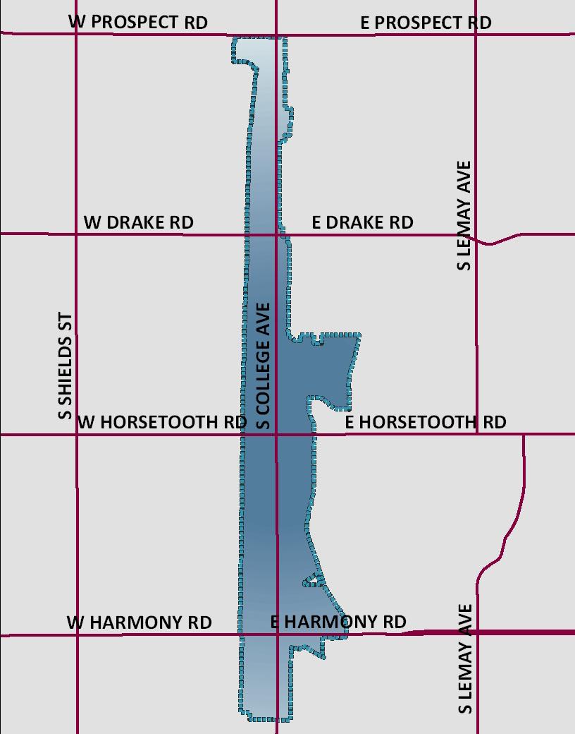
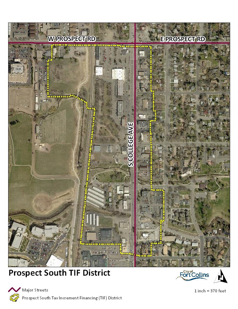
11 Meetings were held before the Planning and Zoning Board and City Council in spring 011 to receive comments and input on this Plan. To the extent provided in Colorado Public Records Act, Colo. Rev. Stat. Title 4, Article 7, Part as the same may be amended from time to time, and pursuant to policies adopted by the Authority, project plans and proposals will be made available to the public. In addition, in connection with review of the Plan and amendment of the Plan to adopt the Tax Increment Financing District Foothills Mall, additional public notice, solicitation of comments, and public hearing were conducted, including review by the Fort Collins Planning and Zoning Board on May 6, 013, culminating in a public hearing before the City Council on May, 013. Description of the Plan Area The Plan Area is approximately 660 acres with 404 parcels of private property, including the right-of-way. The City of Fort Collins Structure Plan identifies this area as a commercial corridor. The City of Fort Collins Zoning Map indicates this area is primarily zoned C-commercial with some additional zones; HC Harmony Corridor, E Employment, and CC-Community Commercial. The Plan Area is depicted on the Boundary Map on the following page (Figure 1). A legal description of the area is attached hereto as Appendix A. The boundary of the Plan Area to which this Plan applies generally includes those properties located within the area bounded by: Prospect Road on the north; The Burlington Northern SantaFe (BNSF) railroad right-of-way on the west; An irregular line following commercial parcels typically one or two parcels deep to the east; and Fairway Lane on the south. Description of the Tax Increment Financing District Prospect South The Tax Increment Financing District - Prospect South (the Prospect South TIF District ) is depicted on the Boundary Map in Figure. A legal description of the district is attached hereto as Appendix B. Description of the Tax Increment Financing District Foothills Mall The Tax Increment Financing District Foothills Mall (the Foothills Mall TIF District ) is depicted on the Boundary Map in Figure 3. A legal description of the district is attached hereto as Appendix C.

12 Figure 1: Midtown Urban Renewal Plan Boundary

13 Figure : Tax Increment Financing District Prospect South

14 Figure 3: Tax Increment Financing District Foothills Mall
15 . Blight Conditions Before an urban renewal plan can be adopted by the City, the determination that an area constitutes a blighted area depends upon the presence of several physical, environmental, and social factors. Blight is indeed attributable to a multiplicity of conditions which, in combination, tend to accelerate the phenomenon of deterioration of an area. The definition of a blighted area is premised upon the definition articulated in the Urban Renewal Law, as follows: Blighted area means an area that, in its present condition and use and, by reason of the presence of at least four of the following factors, substantially impairs or arrests the sound growth of the municipality, retards the provision of housing accommodations, or constitutes an economic or social liability, and is a menace to the public health, safety, morals, or welfare: a. Slum, deteriorated, or deteriorating structures; b. Predominance of defective or inadequate street layout; c. Faulty lot layout in relation to size, adequacy, accessibility, or usefulness; d Unsanitary or unsafe conditions; e Deterioration of site or other improvements; f. Unusual topography or inadequate public improvements or utilities; g. Defective or unusual conditions of title rendering the title nonmarketable; h. The existence of conditions that endanger life or property by fire and other causes; i. Buildings that are unsafe or unhealthy for persons to live or work in because of building code violations, dilapidation, deterioration, defective design, physical construction, or faulty or inadequate facilities; j. Environmental contamination of buildings or property; k.5 The existence of health, safety, or welfare factors requiring high levels of municipal services or substantial physical underutilization or vacancy of sites, building, or other improvements; or l. If there is no objection by the property owner or owners and the tenant or tenants of such owner or owners, if any, to the inclusion of such property in an urban renewal area, "blighted area" also means an area that, in its present condition and use and, by reason of the presence of any one of the factors specified in paragraphs (a) to (k.5) of this subsection (), substantially impairs or arrests the sound growth of the municipality, retards the provision of housing accommodations, or constitutes an economic
16 or social liability, and is a menace to the public health, safety, morals, or welfare. For purposes of this paragraph (l), the fact that an owner of an interest in such property does not object to the inclusion of such property in the urban renewal area does not mean that the owner has waived any rights of such owner in connection with laws governing condemnation. To be able to use the powers of eminent domain, blighted means that five of the eleven factors must be present (C.R.S ()(a)(I)): (a) Blighted area shall have the same meaning as set forth in section (); except that, for the purposes of this section only, blighted area means an area that, in its present condition and use and, by reason of the presence of at least five of the factors specified in section ()(a) to ()(l), substantially impairs or arrests the sound growth of the municipality, retards the provision of housing accommodations, or constitutes an economic or social liability, and is a menace to the public health, safety, morals, or welfare. Source: Colorado Revised Statute (). Several principles have been developed by Colorado courts to guide the determination of whether an area constitutes a blighted area under the Urban Renewal Law. First, the absence of widespread violation of building and health codes does not, by itself, preclude a finding of blight. The definition of blighted area contained in the Urban Renewal Law is broad and encompasses not only those areas containing properties so dilapidated as to justify condemnation as nuisances, but also envisions the prevention of deterioration. Tracy v. City of Boulder, 635 P.d 907, 909 (Colo. Ct. App. 1981). Second, the presence of one well maintained building does not defeat a determination that an area constitutes a blighted area. A determination of blight is based upon an area taken as a whole, and not on a building-by-building basis. Interstate Trust Building Co. v. Denver Urban Renewal Authority, 473 P.d 978, 981 (Colo. 1970). Third, a governing body s determination as to whether an area is blighted.is a legislative question and the scope of review by the judiciary is restricted. Tracy, 635 P.d at 909. A court s role in reviewing such a blight determination is simply to independently verify if the conclusion is based upon factual evidence determined by the City Council at the time of a public hearing to be consistent with the statutory definition. Based on the evidence presented at a public hearing, and in the Midtown Existing Conditions Survey, dated April 011, the City Council, by Resolution , adopted on September 6, 011, and ratified and reaffirmed on February 8, 013, made
17 a finding that the Plan Area was blighted as defined by the Urban Renewal Law, by the existence of the following seven factors: a. Slum, deteriorated, or deteriorating structures b. Predominance of defective or inadequate street layout c. Faulty lot layout in relation to size, adequacy, accessibility, or usefulness d. Unsanitary or unsafe conditions e. Deterioration of site or other improvements f. Unusual topography or inadequate public improvements or utilities k.5. Health, safety, or welfare factors requiring high levels of municipal services or substantial underutilization or vacancy of buildings, sites, or improvements The City Council also found that these factors, taken together, substantially impair the sound growth of the City, constitute an economic and social liability, and negatively affect the public heath, safety and welfare of the community. Based on evidence of the blighted factors, the Plan Area is appropriate for authorized activities of the Authority pursuant to the Urban Renewal Law. 3. Plan Objectives The overall objective of this Plan is to remediate unfavorable existing conditions and prevent further deterioration by implementation of the relevant provisions contained in the following documents: City Plan (The City of Fort Collins Comprehensive Plan) City of Fort Collins Master Street Plan Fort Collins Infill Infrastructure Report City of Fort Collins Master Transportation Plan Mason Corridor Economic Study Midtown Redevelopment Study To do this, this Plan is intended to stimulate private sector development in and around the Plan Area with a combination of private investment, Authority financing, and public investment. The Plan will assist progress toward the following additional objectives: To facilitate redevelopment and new development by private enterprise through cooperation among developers and public agencies to plan, design, and build needed improvements. To address and remedy conditions in the area that impair or arrest the sound growth of the City. To implement the Comprehensive Plan and its related elements.
18 To redevelop and rehabilitate the area in a manner which is compatible with and complementary to unique circumstances in the area. To effectively utilize undeveloped and underdeveloped land. To improve pedestrian, bicycle, vehicular and transit-related circulation and safety. To ultimately contribute to increased revenues for all taxing entities. To encourage the voluntary rehabilitation of buildings, improvements and conditions. To facilitate the enforcement of the laws and regulations applicable to the Plan Area. To watch for market and/or project opportunities to eliminate blight, and when such opportunities exist, to take action within the financial, legal and political limits of the Authority to acquire land, demolish and remove structures, provide relocation benefits, and pursue redevelopment, improvement and rehabilitation projects. 4. Authorized Urban Renewal Activities To support progress toward the objectives, the Authority may undertake any of the following renewal activities, as deemed appropriate for the elimination or prevention of blight factors within the Plan Area, pursuant to the Urban Renewal Law: Public Improvements and Facilities The Authority may cause, finance or facilitate the design, installation, construction and reconstruction of public improvements in the Plan Area. In order to promote the effective utilization of undeveloped and underdeveloped land in the Plan Area, the Authority may, among other things, enter into financial or other agreements with the City of Fort Collins to provide the City with financial or other support in order to encourage or cause the City to invest funds for the improvement of storm drainage, street conditions and other infrastructure deficiencies in the Plan Area. Cooperative Agreements For the purposes of planning and implementing this Plan, the Authority may enter into one or more cooperative agreements with the City or other public entities. Such agreement may include provisions regarding project financing and implementation; design, location, construction of public improvements; and any other matters required to implement this Plan. Potential entities include but not limited to: Xcel Energy, Qwest, Comcast, Poudre Valley Fire Authority, Poudre Valley Rural Electric Association and Fort Collins-Loveland Water District.
19 Purchase of Property In the event that the Authority finds it necessary to purchase any real property for an urban renewal project to remedy blight factors pursuant to the Urban Renewal Law and this Plan, the Authority may do so by any legal means available, including the exercise of the power of eminent domain, pursuant to the Urban Renewal Law. If the power of eminent domain is to be exercised for the purpose of transfer of property to another private person or entity, the Authority s decision whether to acquire the property through eminent domain shall be guided by the following criteria, with the understanding that these guidelines shall not be construed to constrain the Authority s legal ability to exercise the power of eminent domain: All requirements of the Urban Renewal Law, including eminent domain procedures, have been met. Other possible alternatives have been thoroughly considered by the Authority. Good faith negotiations by the Authority and/or the project developer have been rejected by the property owner. Reasonable efforts have been undertaken to: (a) understand and address the property owner's position and his or her desires for the property and for any existing business on the site, and (b) work with the owner to either include the owner in project planning or purchase the property and relocate the owner in accordance with the Urban Renewal Law on terms and conditions acceptable to the owner. Demolition, Clearance, Environmental Remediation, and Site Prep The Authority may on a case-by-case basis, elect to demolish or to cooperate with others to clear buildings, structures, and other improvements. Development activities consistent with this Plan may require such demolition and clearance to eliminate unhealthy, unsanitary, and unsafe conditions, eliminate obsolete and other uses detrimental to the public welfare, and otherwise remove and prevent the spread of deterioration. Property Disposition The Authority may sell, lease, or otherwise transfer real property or any interest in real property subject to covenants, conditions and restrictions, including architectural and design controls, time restrictions on development, and building requirements, as it deems necessary to develop such property. Redevelopment Agreements The Authority may enter into redevelopment agreements with property owners or developers in the Plan Area to facilitate participation and assistance that the Authority may choose to provide to such owners or developers. These may include provisions
20 regarding project planning, public improvements, financing, design, and any other matters allowed pursuant to the Urban Renewal Law. Relocation Assistance It is not expected that the activities of the Authority will displace any person, family, or business. However, to the extent that in the future the Authority may purchase property causing displacement of any person, family, or business, it shall develop a relocation program to assist any such party in finding another location pursuant to the Urban Renewal Law, and provide relocation benefits consistent with the Urban Renewal Law. There shall be no displacement of any person or business without there being in place a relocation program, which program shall become a part of this Plan when adopted. Hiring The Authority may employ consultants, agents, and employees, permanent and temporary, and it shall determine their qualifications, duties, and compensation. Legal Authority The Authority may also exercise all other powers given to it under the Urban Renewal Law. Catalyst and Enhancement Projects Rehabilitation and redevelopment of the properties surrounding the Plan Area that will continue to foster cleanup, preservation and redevelopment of nearby properties. Additional public infrastructure, not limited to pedestrian amenities, enhanced landscaping, public transportation improvements, public utilities, or public art and architectural features as well as access to services, meeting facilities and shopping options may also further redevelopment of the Plan Area. 5. Development Standards and Procedures All development within the Plan Area shall conform to the Land Use Code and any site specific zoning regulations or policies which might impact properties, all as in effect and as may be amended from time to time. While State statute authorizes the Authority to undertake zoning and planning activities to regulate land use, maximum densities, and building requirements in the Plan Area, the City will regulate land use and building requirements through existing municipal codes and ordinances.
21 6. Conformance Urban Renewal Law This Plan is in conformity with and subject to the applicable statutory requirements of the Urban Renewal Law. City Plan The City s adopted Comprehensive Plan, known as City Plan, describes desirable land use and transportation patterns, with goals and policies for those topics along with community appearance and design, the environment, open lands, housing, the economy, and growth management. Briefly summarized, the land use pattern envisioned by these plans for the Plan Area is a commercial corridor well-integrated with surrounding development. The Plan Area is envisioned to evolve with improved community design and streetscapes, in an interconnected framework of streets and blocks. One of the purposes of this Plan is to implement the vision for the Plan Area as a commercial corridor with mixed-use residential improvements, as well as create a connection to the Mason Corridor for improved transit circulation. This Plan is intended to provide mechanisms to facilitate implementation of City Plan, and therefore it is in direct conformance with City Plan. The following excerpts from City Plan highlight the linkage between City Plan and this Urban Renewal Plan. These are representative excerpts, and not an all-inclusive listing of relevant statements: Principle EH 4: The City will encourage the redevelopment of strategic areas within the community as defined in the Community and Neighborhood Livability and Neighborhood Principles and Policies. Policy EH 4.1: Prioritize Targeted Redevelopment Areas Create and utilize strategies and plans, as described in the Community and Neighborhood Livability and Neighborhood chapter s Infill and Redevelopment section, to support redevelopment areas and prevent areas from becoming blighted. The Targeted Infill and Redevelopment Areas (depicted on Figure LIV 1 in the Community and Neighborhood Livability chapter) shall be a priority for future development, capital investment, and public incentives. Policy EH 4.: Reduce Barriers to Infill Development and Redevelopment Develop new policies and modify current policies, procedures, and practices to reduce and resolve barriers to Infill development and redevelopment. Emphasize new policies and modifications to existing policies that support a sustainable, flexible, and predictable approach to infill development and redevelopment.
22 Policy LIV 5.1: Encourage Targeted Redevelopment and Infill Encourage redevelopment and infill in Activity Centers and Targeted Infill and Redevelopment Areas identified on the Targeted Infill and Redevelopment Areas Map. The purpose of these areas is to: Promote the revitalization of existing, underutilized commercial and industrial areas. Concentrate higher density housing and mixed-use development in locations that are currently or will be served by high frequency transit in the future and that can support higher levels of activity. Channel development where it will be beneficial and can best improve access to jobs, housing, and services with fewer and shorter auto trips. Promote reinvestment in areas where infrastructure already exists. Increase economic activity in the area to benefit existing residents and businesses and, where necessary, provide the stimulus to redevelop. Areas identified on the Targeted Infill and Redevelopment Areas Map are parts of the city where general agreement exists that redevelopment and infill would be beneficial. These areas are generally considered a priority for efforts to reduce barriers and concentrate public investment in infrastructure. However, of the areas identified, the community spine (see Policy LIV 5.) shall be the highest priority location for such efforts. Areas not shown on the Targeted Infill and Redevelopment Areas map are not excluded from redevelopment and infill activity, but are considered to be lower priority or where activity is less likely to occur for other reasons. Policy LIV 5.: Target Public Investment along the Community Spine Together, many of the Targeted Redevelopment Areas and Activity Centers form the community spine of the city along College Avenue and the Mason Corridor. The community spine shall be considered the highest priority area for public investment in streetscape and urban design improvements and other infrastructure upgrades to support infill and redevelopment and to promote the corridor s transition to a series of transit-supportive, mixed-use activity centers over time. Established residential neighborhoods adjacent to College Avenue and the Mason Corridor will be served by improvements to the community spine over time, but are not intended to be targeted for infill or redevelopment. Policy LIV 5.3: Policy LIV 5.3 Identify Additional Redevelopment and Infill Areas as Appropriate Utilize subarea plans to help designate areas for redevelopment and infill that are not identified on the Targeted Infill and Redevelopment Areas Map. Within these plans, support the development of appropriate design standards to protect the character of neighborhoods and to ensure conformance with City Plan.
23 Principle LIV 34: General Commercial Districts will include a wide range of community and regional uses, in various sizes and scales, designed for convenient access by all modes of travel, efficient circulation, and a comfortable pedestrian environment. Policy LIV 34.: Mix of Uses Although many existing General Commercial Districts in the City consist of single-use commercial centers today, the incorporation of a broader mix of uses is desirable over time: Principal uses: Retail, restaurants, office, and other commercial services. Supporting uses: Entertainment, high-density residential, day care (adult and child), and other supporting uses. Policy LIV 34.3: Support the Revitalization of Existing Strip Commercial Corridor Developments Encourage and support the gradual evolution of existing, auto-oriented strip commercial areas to a more compact, pedestrian and transit-oriented pattern of development over time through infill and redevelopment. Establish enhanced walking connections between destinations. Principle LIV 35: Community Commercial Districts will be communitywide destinations and hubs for a high-frequency transit system. They will be quality mixed-use urban activity centers that offer retail, offices, services, small civic uses, and higher density housing, in an environment that promotes walking, bicycling, transit and ridesharing. Policy LIV 35.4: Transform through Infill and Redevelopment Support the transformation of existing, underutilized Community Commercial Districts through infill and redevelopment over time to more intense centers of activity that include a mixture of land uses and activities, an enhanced appearance, and access to all transportation modes. Principle LIV 43: Enhanced Travel Corridors will be strategic and specialized Transportation Corridors that contain amenities and designs that specifically promote walking, the use of mass transit, and bicycling. Enhanced Travel Corridors will provide high-frequency/high efficiency travel opportunities for all modes linking major activity centers and districts in the city. Policy LIV 43.3: Support Transit-Supportive Development Patterns Support the incorporation of higher intensity, transit-supportive development along Enhanced Travel Corridors through infill and redevelopment. Encourage the densities and broader mix of uses necessary to support walking, bicycling, and transit use while accommodating efficient automobile use.
24 7. Project Financing Specific projects may be financed in whole or in part by the Authority, under the tax increment financing (TIF) provisions of CRS (9)(a) of the Urban Renewal Law, or by any other available source of financing authorized to be undertaken by the Authority pursuant to CRS of the Urban Renewal Law. The Authority is authorized to: Finance urban renewal projects within the Plan Area with revenues from property tax increments, sales tax increments, interest income, federal loans or grants, agreements with public, quasi-public or private parties and entities, loans or advances from any other available source, and any other available sources of revenue. Issue bonds and incur other obligations contemplated by the Urban Renewal Law in an amount sufficient to finance all or any part of a project within the Plan Area. Borrow funds and create indebtedness in any authorized form in carrying out this Plan. Any principal and interest on such indebtedness may be paid from property tax increments, sales tax increments or any other funds, revenues, assets or properties legally available to the Authority. Such methods may be combined to finance all or part of the Plan activities. Tax Increment Financing (TIF) District Boundaries If permissible by the Urban Renewal Law, the Authority is authorized to create TIF districts within the Plan Area that can include, but are not limited to a single parcel or multiple parcels for a qualified project. Accordingly, the Plan may be amended when the TIF district is decided upon by the Authority, and incremental property tax and/or sales tax revenues attributable to the redevelopment in the Plan Area to pay the indebtedness incurred by the Authority. Reference Figure and Figure 3 for an examples.the Prospect South Tax Increment District was established when this Plan was adopted. The Foothills Mall Tax Increment District was established when the Plan was amended on May, 013. Additional TIF districts may be established in the future by amendment of this Plan. Property Tax IncrementProspect South Tax Increment District The primary method of financing the projects undertaken in furtherance of this Urban Renewal Plan in the Prospect South Tax Increment District shall be the use of property tax increment financing pursuant to Section (9), C.R.S. All property taxes collected within the Prospect South Tax Increment District shall be divided as follows:
25 a) That portion of property taxes equal to the amount collected within the boundaries of the Prospect South Tax Increment District in the twelve-month period ending on the last day of the month prior to the effective date of the approval of this tax allocation provision shall be paid into the funds of each such public body as are all other taxes collected by or for such public body. b) The portion of such property taxes in excess of the amounts described in paragraph a), above, shall be allocated to and, when collected, paid into a special fund to fund the Authority s obligations with respect to any project for the Prospect South Tax Increment District, including payment of the principal of, the interest on, and any premiums due in connection with the bonds, loans or advances to, or indebtedness incurred by (whether funded, refunded, assumed, or otherwise) the Authority for financing or refinancing, in whole or in part, the Urban Renewal projects for the Prospect South Tax Increment District, or to make payments under an agreement executed pursuant to Section (11). c) When such bonds, loans, advances, and indebtedness, if any, including interest thereon and any premiums due in connection therewith, have been paid, but in no event later than 5 years following the adoption of this tax allocation provision, any excess property tax collections not allocated pursuant to this paragraph or any Cooperation Agreement between the Authority and the City or other taxing jurisdiction, shall be paid into the funds of said jurisdiction or public body. Unless and until the total property tax collections in the Prospect South Tax Increment District exceed the base year property tax collections in the Prospect South Tax Increment District, as provided in paragraph a), above, all such property tax collections shall be paid into the funds of the appropriate public body. The Authority reserves the right to enter into Cooperation Agreements with select taxing jurisdictions relative to allocation of incremental tax revenues. d) In the event that there is a general reassessment of taxable property valuations in Larimer County, which are subject to division of valuation for assessment between base and increment, as provided above, the portions of valuations for assessment to be allocated as provided above shall be proportionately adjusted in accordance with such reassessment. Note that at the time of this Plan adoption, such a general reassessment occurs every two years, in the odd-numbered years. Foothills Mall Tax Increment District The primary method of financing the projects undertaken in furtherance of this Urban Renewal Plan in the Foothills Mall Tax Increment District shall be the use of property tax and sales tax increment financing pursuant to Section (9), C.R.S. For purposes of the tax allocation provision of this Plan related to the Foothills Mall Tax Increment District, the term sales tax shall mean the sales tax imposed by the City at a rate of
26 .5% (or such lesser rate as agreed to by the City and the Authority) on sales of goods and services that are subject to municipal sales taxes pursuant to the Fort Collins Municipal Code (as it may exist from time to time). All property taxes and sales taxes collected within the Foothills Mall Tax Increment District shall be divided as follows: a) That portion of property taxes and sales taxes equal to the amount collected within the boundaries of the Foothills Mall Tax Increment District in the twelve-month period ending on the last day of the month prior to the effective date of the approval of this tax allocation provision shall be paid into the funds of each such public body as are all other taxes collected by or for such public body. b) The portion of such property taxes and sales taxes in excess of the amounts described in paragraph a), above, shall be allocated to and, when collected, paid into a special fund to fund the Authority s obligations with respect to any project for the Foothills Mall Tax Increment District, including payment of the principal of, the interest on, and any premiums due in connection with the bonds, loans or advances to, or indebtedness incurred by (whether funded, refunded, assumed, or otherwise) the Authority for financing or refinancing, in whole or in part, the Urban Renewal projects for the Foothills Mall Tax Increment District, or to make payments under an agreement executed pursuant to Section (11). c) When such bonds, loans, advances, and indebtedness, if any, including interest thereon and any premiums due in connection therewith, have been paid, but in no event later than 5 years following the adoption of this tax allocation provision, any excess property and sales tax collections not allocated pursuant to this paragraph or any Cooperation Agreement between the Authority and the City or other taxing jurisdiction, shall be paid into the funds of said jurisdiction or public body. Unless and until the total property and sales tax collections in the Foothills Mall Tax Increment District exceed the base year property and sales tax collections in the Foothills Mall Tax Increment District, as provided in paragraph a), above, all such property and sales tax collections shall be paid into the funds of the appropriate public body. The Authority reserves the right to enter into Cooperation Agreements with select taxing jurisdictions relative to allocation of incremental tax revenues. d) In the event that there is a general reassessment of taxable property valuations in Larimer County, which are subject to division of valuation for assessment between base and increment, as provided above, the portions of valuations for assessment to be allocated as provided above shall be proportionately adjusted in accordance with such reassessment. Note that at the time of this Plan adoption, such a general reassessment occurs every two years, in the odd-numbered years. In the event the City increases its sales tax rate, there will be no adjustment to the sales tax increment portion of this provision unless this Plan is amended.
27 A fund for financing projects may be accrued and used by the Authority under the property tax allocation financing provisions of the Urban Renewal Law. Under this method, property taxes levied after the effective date of the approval of this Plan upon taxable property in the Plan Area each year by or for the benefit of any public body shall be divided for a period not to exceed twenty-five (5) years after the effective date of the adoption of the tax allocation provision, as follows: Formatted: Normal Base Amount - That portion of the taxes which are produced by the levy at the rate fixed each year by or for such public body upon the valuation for assessment of taxable property in the Plan Area last certified prior to the effective date of approval of the Plan or, as to an area later added to the Plan Area, the effective date of the modification of the Plan, shall be paid into the funds of each such public body as are all other taxes collected by or for said public body. Increment amount - That portion of said property taxes in excess of such base amount shall be allocated to and, when collected, paid into a special fund of the Authority to pay the principal of, the interest on, and any premiums due in connection with the bonds of, loans or advances to, or indebtedness incurred by (whether funded, refunded, assumed or otherwise) the Authority for financing or refinancing, in whole or in part, a specific project. Such increment amount shall also be used to pay for the Authority's financial obligations incurred in the implementation of this Plan. Unless and until the total valuation for assessment of the taxable property in the Plan Area exceeds the base valuation for assessment of the taxable property in the Plan Area, all of the taxes levied upon taxable property in the Plan Area shall be paid into the funds of the respective public bodies. In the event that there is a general reassessment of taxable property valuations in Larimer County, which are subject to division of valuation for assessment between base and increment, as provided above, the portions of valuations for assessment to be allocated as provided above shall be proportionately adjusted in accordance with such reassessment. Note that at the time of this Plan adoption, such a general reassessment occurs every two years, in the odd-numbered years. When such bonds, loans, advances, indebtedness, and financial obligations, including interest thereon and any premiums due in connection therewith, have been paid, all taxes upon the taxable property in the Plan Area shall be paid into the funds of the respective public bodies.
28 Sales Tax Increment The project may also be financed by the Authority under the sales tax allocation financing provisions of the Urban Renewal Law. The act allows that upon the adoption or amendment of an URP, sales taxes flowing to the City may be "frozen" at their current level. The current level is established based on the previous twelve months prior to the adoption of this Plan. Thereafter, the City can continue to receive this fixed sales tax revenue. The Authority thereafter may receive all, or an agreed upon portion of the additional sales taxes (the increment) which are generated above the base. The Authority may use these incremental revenues to finance the issuance of bonds, reimburse developers for public improvement costs, reimburse the City for public improvement costs and pay off financial obligations and other debts incurred in the administration of the URP. This increment is not an additional sales tax, but rather is a portion of the established tax collected by the City, and the sales tax increment resulting from redevelopment efforts and activities contemplated in this Plan. Tax Increment Reimbursement Tax increment revenues may be used to reimburse the City and/or a developer for costs incurred for improvements related to a project to pay the debt incurred by the Authority with such entities for urban renewal activities and purposes. Tax incremental revenues may also be used to pay bonded indebtedness, financial obligations and debts of the Authority related to urban renewal activities under this Plan. 8. Modifications to the Plan This Plan may be modified pursuant to requirements and procedures set forth in CRS of the Urban Renewal Law governing such modifications or amendments to the extent such modifications or amendments do not conflict with the agreements. Nothing herein shall be construed to require the Authority to first obtain the permission of any party to an Agreement prior to amending or modifying this Plan. 9. Reasonable Variations The Authority shall have the ability to approve reasonable variations (as determined by the Board) from the strict application of these Plan provisions, so long as such variations reasonably accommodate the intent and purpose of this Plan and the Urban Renewal Law. Plan provisions may be altered by market conditions, redevelopment opportunities and/or the needs of the community affected by the Plan. 10. Effective Date of the Plan and TIF Provisions This plan shall be effective upon its final approval by the Fort Collins City Counciland the Prospect South TIF District provision took effect on September 6, 011. The Foothills
29 Mall TIF District provision took effect on May, 013. Except as otherwise permitted under the Urban Renewal Law, the term of the TIF period is twenty-five (5) years from the effective date of the Planthe adoption of the relevant TIF provision, unless the Authority deems, to the extent consistent with the terms in the Agreements, that all activities to accomplish the Project have been completed and all debts incurred to finance such activities and all expenses of the Authority have been repaid. In that event, the Authority may declare the Plan fully implemented.
30 Appendix A Legal Description DESCRIPTION OF THE AREA A tract of land located in Sections 3, 4, 5, 6, 35 and 36 of Township 7 North, Range 69 West and in Sections 1 and of Township 6 North, Range 69 West, all of the Sixth Principal Meridian, City of Fort Collins, Larimer County, Colorado, contained within the following described area; Beginning at the center of South College Avenue with its intersection with the easterly extension of the southerly right of way of Prospect Road, the TRUE POINT OF BEGINNING of this description; THENCE westerly along the said extended line and along the said southerly right of way to the west line of the plat of Griffin Plaza Subdivision ; THENCE southerly, westerly and southerly along the said west line to the southerly line of the said plat of Griffin Plaza Subdivision ; THENCE easterly and southerly along the said southerly line to the westerly right of way of the BNSF Railway; THENCE easterly and radially to the said right of way to the easterly right of way of the BNSF Railway; THENCE southerly along the said easterly right of way to the east west centerline of the said Section 6; THENCE easterly along the said east west centerline and returning to the said easterly right of way of the BNSF Railway; THENCE continuing southerly along the said easterly right of way to the south line of the said Section 6; THENCE westerly along the said south line and returning to the said easterly right of way of the BNSF Railway; THENCE continuing southerly along the said easterly right of way to the north line of the said Section ; THENCE easterly along the said north line and returning to the said easterly right of way of the BNSF Railway; THENCE continuing southerly along the said easterly right of way to the north line of the plat of George T. Sanders Co. P.U.D. ; THENCE easterly along the said north line to the westerly right of way of Fossil Boulevard; THENCE southerly along the said westerly right of way to the westerly extension of the southerly right of way of West Fairway Lane; THENCE easterly along the said extended line and along the said southerly right of way, its easterly extension and along the southerly right of way of Fairway Lane to the southerly extension of the east line of the plat of Replat Of A Part Of Fairway Estates ; THENCE northerly along the said extended line and along the said east line of the Replat Of A Part Of Fairway Estates, along the east line of the plat of Replat Of A Part OF Lot 7, Lot 8, Lot 9, And A Part Of Lot 10 Of the Replat Of A Part Of Fairway Estates and continuing along the east line of the said plat of Replat Of A Part Of Fairway Estates and its northerly extension to the southwest corner of that certain tract of land as described in a Warranty Deed Recorded April, 00 at Reception No records of the Clerk and Recorder of the said Larimer County; THENCE easterly along the southerly line of the said tract described at Reception No to the southwest corner of the plat of Fort Collins Supportive Housing Subdivision ; THENCE easterly along the southerly line of the said plat to the southeast corner of the said Fort Collins Supportive Housing Subdivision ; THENCE northerly along the easterly line of the said plat to the southerly right of way of
31 East Harmony Road; THENCE easterly along the said southerly right of way and its easterly extension to the easterly right of way of Hogan Drive; THENCE northerly to the intersection of the northerly right of way of East Harmony Road with the easterly right of way of John F. Kennedy Parkway; THENCE northerly along the said easterly right of way of John F. Kennedy Parkway and along the easterly right of way s extension through intersecting side streets through the East Horsetooth Road right of way, to the southerly line of Tract Nine as shown on the plat of The Foothills Fashion Mall Expansion ; THENCE easterly along the southerly line of the said Tract Nine to the westerly right of way of Stanford Road; THENCE northerly along the said westerly right of way to the northerly line of the plat of The Foothills Fashion Mall Foley s Expansion ; THENCE westerly along the said northerly line to the easterly line of Tract K of the plat of Southmoor Village Fifth Filing ; THENCE southerly along the said easterly line of Tract K to the southerly line of the said Tract K; THENCE westerly along the said southerly line to the westerly line of the said Tract K; THENCE northerly along the said westerly line to the northerly line of the said plat of Southmoor Village Fifth Filing ; THENCE westerly along the said northerly line to the easterly line of Tract H of the said plat of Southmoor Village Fifth Filing ; THENCE southerly along the said easterly line to the southerly line of the said Tract H; THENCE westerly along the southerly line of the said Tract H to the southerly right of way of Remington Street as shown on the plat of A Replat Of Tracts F, G, And J, And Vacated Service Road, Southmoor Village Fifth Filing ; THENCE westerly along the said southerly right of way to the westerly right of way of the said Remington Street; THENCE northerly along the said westerly right of way and along the westerly right of way s extension through intersecting side streets, to the northerly right of way of Harvard Avenue; THENCE easterly along the said northerly right of way to the easterly line of Lot 13 of the plat of Plat Of Thunderbird Estates Seventh Filing ; THENCE northerly along the easterly line of Lot 13 and its northerly extension to the easterly line of the plat of Thunderbird Estates Sixth Filing ; THENCE northerly along the said easterly line to the southerly line of Lot 3 of the said plat of Thunderbird Estates Sixth Filing ; THENCE westerly along the said southerly line to the westerly line of the said Lot 3; THENCE northerly along the said westerly line to the southerly right of way of Drake Road; THENCE westerly along the said southerly right of way to the southerly extension of the easterly line of Lot 1 of the Plat of The Resubdivision of Tract A, South College Heights Fourth Subdivision ; Thence northerly along the said southerly extension and along the said easterly line of Lot 1, to the southerly right of way of Princeton Avenue; Thence westerly along the said southerly right of way to the easterly right of way of South College Avenue; THENCE northerly along the said easterly right of way and along the easterly right of way s extension through intersecting side streets, to the northerly right of way of Rutgers Avenue; THENCE easterly along the said northerly right of way to the easterly line of the Rutgers Building Condominiums ; THENCE northerly along the said easterly line to the southerly line of the plat of Raising Cane s ; THENCE easterly along the said southerly line to the easterly line of the said plat of Raising Cane s ; THENCE northerly along the said easterly line to the southerly line of the plat of A Replat of A Part of Tract 1, Replat of Block and Lots 1 to 7 Inclusive of
32 Block 1 of the St. Vrain Subdivision ; THENCE easterly along the said southerly line to the westerly right of way of Remington Street; THENCE northerly along the said westerly right of way to the southerly right of way of Spring Park Drive; THENCE westerly along the said southerly right of way to the southerly extension of the easterly line of the plat of Human Bean At Spring Creek ; THENCE northerly along the said extended line and along the said easterly line and along the easterly lines of Lots 1 through 7 of the plat of Moran s Subdivision to the southerly right of way of East Stuart Street; THENCE northerly to the northerly right of way of East Stuart Street and to the easterly line of the West 180 feet of Lot 5 of the plat of Maynard Subdivision ; THENCE northerly along the said easterly line to the northerly line of the said Lot 5; THENCE westerly along the said northerly line to the easterly line of Lot of the plat of A Replat of Maynard Subdivision Being a Resubdivision of the West 350 Feet of Lots 3 & 4 of Maynard Subdivision ; THENCE northerly along the said easterly line and along the easterly line of Lot 1 of the said plat of A Replat of Maynard Subdivision Being a Resubdivision of the West 350 Feet of Lots 3 & 4 of Maynard Subdivision to the northerly line of the said plat of A Replat of Maynard Subdivision Being a Resubdivision of the West 350 Feet of Lots 3 & 4 of Maynard Subdivision ; THENCE easterly along the said northerly line to the easterly line of the west 40 feet of Lot of the said plat of Maynard Subdivision ; THENCE northerly along the said easterly line and its northerly extension to the southerly line of the northerly 3 feet of the said plat of Maynard Subdivision ; THENCE westerly along the said southerly line to the easterly line of the westerly 13 feet of Lots 14 and 1 of the said plat of Maynard Subdivision ; THENCE northerly along the said easterly line and its northerly extension to the northerly right of way of Parker Street; THENCE westerly along the said northerly right of way to the easterly right of way of the north-south alley through Block 1 of the plat of I.C. Bradley s Addition To The City Of Fort Collins ; THENCE northerly along the said easterly alley right of way to the southerly right of way of East Prospect Road; THENCE westerly along the said southerly right of way to the POINT OF BEGINNING. Excepting there from all of the plat of Amended Final Plat of Parkway Townhomes P.U.D. All Plats referred to in the above described description are Plats of record with the Clerk and Recorder of Larimer County. I hear by state that the above description was prepared by me and is true and correct to the best of my professional knowledge belief and opinion. The above described tract is based upon previously recorded plats and deeds and not upon an actual field survey. Wallace C. Muscott Colorado P.L.S PO Box 580 Fort Collins, CO 8055 April 0, 011
33 Appendix B Legal Description DESCRIPTION OF THE TAX INCREMENT FINANCING DISTRICT PROSPECT SOUTH A tract of land located in Sections 3 and 4 of Township 7 North, Range 69 West West of the Sixth Principal Meridian, City of Fort Collins, Larimer County, Colorado, contained within the following described area; Beginning at the center of South College Avenue with its intersection with the easterly extension of the southerly right of way of Prospect Road, the TRUE POINT OF BEGINNING of this description; THENCE westerly along the said extended line and along the said southerly right of way to the west line of the plat of Griffin Plaza Subdivision ; THENCE southerly, westerly and southerly along the said west line to the southerly line of the said plat of Griffin Plaza Subdivision ; THENCE easterly and southerly along the said southerly line to the westerly right of way of the BNSF Railway; THENCE easterly and radially to the said right of way to the easterly right of way of the BNSF Railway; THENCE southerly along the said easterly right of way to the northerly line of the plat of Whole Foods Center ; THENCE easterly along the said northerly line to the westerly line of Tract E of the plat of University Shopping Center ; THENCE southerly along the said westerly line to the southerly line of the said Tract E ; THENCE easterly along the said southerly line to the westerly right of way of South College Avenue; THENCE easterly to the intersection of the easterly right of way of South College Avenue with the northerly right of way of Rutgers Avenue; THENCE easterly along the said northerly right of way to the easterly line of the Rutgers Building Condominiums ; THENCE northerly along the said easterly line to the southerly line of the plat of Raising Cane s ; THENCE easterly along the said southerly line to the easterly line of the said plat of Raising Cane s ; THENCE northerly along the said easterly line to the southerly line of the plat of A Replat of A Part of Tract 1, Replat of Block and Lots 1 to 7 Inclusive of Block 1 of the St. Vrain Subdivision ; THENCE easterly along the said southerly line to the westerly right of way of Remington Street; THENCE northerly along the said westerly right of way to the southerly right of way of Spring Park Drive; THENCE westerly along the said southerly right of way to the southerly extension of the easterly line of the plat of Human Bean At Spring Creek ; THENCE northerly along the said extended line and along the said easterly line and along the easterly lines of Lots 1 through 7 of the plat of Moran s Subdivision to the southerly right of way of East Stuart Street; THENCE northerly to the northerly right of way of East Stuart Street and to the easterly line of the West 180 feet of Lot 5 of the plat of Maynard Subdivision ; THENCE northerly along the said easterly line to the northerly line of the said Lot 5; THENCE westerly along the said northerly line to the easterly line of Lot of the plat of A Replat of Maynard Subdivision Being a Resubdivision of the West 350 Feet of Lots 3 & 4 of Maynard Subdivision ; THENCE northerly along the said easterly line and along the easterly line of Lot 1 of the said plat of A Replat of Maynard Subdivision Being a Resubdivision of the West 350 Feet of Lots 3 & 4 of Maynard Subdivision to the northerly line of the said
34 plat of A Replat of Maynard Subdivision Being a Resubdivision of the West 350 Feet of Lots 3 & 4 of Maynard Subdivision ; THENCE easterly along the said northerly line to the easterly line of the west 40 feet of Lot of the said plat of Maynard Subdivision ; THENCE northerly along the said easterly line and its northerly extension to the southerly line of the northerly 3 feet of the said plat of Maynard Subdivision ; THENCE westerly along the said southerly line to the easterly line of the westerly 13 feet of Lots 14 and 1 of the said plat of Maynard Subdivision ; THENCE northerly along the said easterly line and its northerly extension to the northerly right of way of Parker Street; THENCE westerly along the said northerly right of way to the easterly right of way of the north-south alley through Block 1 of the plat of I.C. Bradley s Addition To The City Of Fort Collins ; THENCE northerly along the said easterly alley right of way to the southerly right of way of East Prospect Road; THENCE westerly along the said southerly right of way to the POINT OF BEGINNING. All Plats referred to in the above described description are Plats of record with the Clerk and Recorder of Larimer County. I hear by state that the above description was prepared by me and is true and correct to the best of my professional knowledge belief and opinion. The above described tract is based upon previously recorded plats and deeds and not upon an actual field survey. Wallace C. Muscott Colorado P.L.S PO Box 580 Fort Collins, CO 8055 April 0, 011
35 Appendix C Legal Description DESCRIPTION OF THE TAX INCREMENT FINANCING DISTRICT Foothills Mall A TRACT OF LAND LOCATED IN THE SOUTHWEST QUARTER OF SECTION 5 AND THE SOUTHEAST QUARTER OF SECTION 6, TOWNSHIP 7 NORTH, RANGE 69 WEST OF THE SIXTH P.M.; CITY OF FORT COLLINS, COUNTY OF LARIMER, STATE OF COLORADO; BEING MORE PARTICULARLY DESCRIBED AS FOLLOWS: BEGINNING AT THE WEST QUARTER CORNER OF SAID SECTION 5, AND CONSIDERING THE WEST LINE OF THE SOUTHWEST QUARTER OF SAID SECTION 5 AS HAVING AN ASSUMED BEARING OF S W, SAID LINE BEING MONUMENTED ON ITS NORTH END BY A 3" ALUMINUM CAP STAMPED LS 013, AND ON ITS SOUTH END BY A -1/" ALUMINUM CAP STAMPED LS 1483, WITH ALL BEARINGS CONTAINED HEREIN RELATIVE THERETO; THENCE ALONG THE NORTHERLY BOUNDARY OF LOT 1 OF THE REPLAT OF TRACTS F, G, AND J, AND VACATED SERVICE ROAD, SOUTHMOOR VILLAGE, FIFTH FILING AND THE WESTERLY EXTENSION THEREOF, N89 5'45"E, A DISTANCE OF FEET TO A POINT ON THE WESTERLY RIGHT OF WAY LINE OF REMINGTON STREET; THENCE CONTINUING ALONG SAID NORTHERLY BOUNDARY THE FOLLOWING FIVE (5) COURSES: 1) ALONG THE WESTERLY RIGHT OF WAY LINE OF REMINGTON STREET, S00 05'37"W, A DISTANCE OF FEET; ) ALONG THE SOUTHERLY RIGHT OF WAY LINE OF REMINGTON STREET, N89 5'45"E, A DISTANCE OF FEET; 3) S51 41'04"E, A DISTANCE OF FEET; 4) S89 35'3"E, A DISTANCE OF FEET; 5) N00 05'37"E, A DISTANCE OF FEET; THENCE CONTINUING ALONG SAID NORTHERLY BOUNDARY AND ITS EASTERLY EXTENSION, N89 5'45"E, A DISTANCE OF FEET TO A POINT ON THE EASTERLY RIGHT OF WAY LINE OF MATHEWS STREET, SAID POINT ALSO BEING THE NORTHWEST CORNER OF TRACT K, SOUTHMOOR VILLAGE, FIFTH FILING; THENCE ALONG THE WESTERLY, SOUTHERLY, AND EASTERLY BOUNDARIES OF SAID TRACT K THE FOLLOWING FIVE (5) COURSES: 1) ALONG SAID EASTERLY RIGHT OF WAY LINE OF MATHEWS STREET, S00 14'56"E,
36 A DISTANCE OF FEET; ) 3.98 FEET ALONG THE ARC OF A TANGENT CURVE TO THE LEFT, HAVING A RADIUS OF FEET, A CENTRAL ANGLE OF 91 36'53", AND A CHORD WHICH BEARS S46 03'"E A DISTANCE OF 1.51 FEET; 3) 11.0 FEET ALONG THE ARC OF A REVERSE CURVE, HAVING A RADIUS OF FEET, A CENTRAL ANGLE OF 01 45'00", AND A CHORD WHICH BEARS N89 00'07"E A DISTANCE OF 11.0 FEET; 4) N89 5'37"E, A DISTANCE OF FEET; 5) N00 07'3"W, A DISTANCE OF 30.1 FEET TO THE NORTHWEST CORNER OF TRACT B OF THE FOOTHILLS FASHION MALL FOLEY S EXPANSION; THENCE ALONG THE NORTHERLY BOUNDARY OF TRACTS B AND A OF SAID FOOTHILLS FASHION MALL FOLEY S EXPANSION, N89 5'46"E, A DISTANCE OF FEET TO A POINT ON THE WESTERLY RIGHT OF WAY LINE OF STANFORD ROAD; THENCE ALONG SAID WESTERLY RIGHT OF WAY LINE THE FOLLOWING SEVEN (7) COURSES: 1) ALONG THE EASTERLY BOUNDARY OF TRACT B OF SAID FOOTHILLS FASHION MALL FOLEY S EXPANSION, FEET ALONG THE ARC OF A NON-TANGENT CURVE TO THE RIGHT, HAVING A RADIUS OF 1, FEET, A CENTRAL ANGLE OF 16 48'53", AND A CHORD WHICH BEARS S08 17'1"W A DISTANCE OF FEET; ) CONTINUING ALONG SAID EASTERLY BOUNDARY, S16 41'39"W, A DISTANCE OF FEET; 3) ALONG THE EASTERLY BOUNDARY OF THE FOOTHILLS FASHION MALL EXPANSION, S16 41'36"W, A DISTANCE OF FEET; 4) CONTINUING ALONG SAID EASTERLY BOUNDARY, 37.6 FEET ALONG THE ARC OF A TANGENT CURVE TO THE LEFT, HAVING A RADIUS OF 1, FEET, A CENTRAL ANGLE OF 16 50'30", AND A CHORD WHICH BEARS S08 16'1"W A DISTANCE OF FEET; 5) CONTINUING ALONG SAID EASTERLY BOUNDARY, S00 08'53"E, A DISTANCE OF FEET; 6) CONTINUING ALONG SAID EASTERLY BOUNDARY, S05 51'3"E, A DISTANCE OF FEET;
37 7) CONTINUING ALONG SAID EASTERLY BOUNDARY AND ITS SOUTHERLY EXTENSION, S00 08'53"E, A DISTANCE OF FEET TO A POINT ON THE SOUTHERLY BOUNDARY OF THAT TRACT OF LAND DESCRIBED IN THE SPECIAL WARRANTY DEED RECORDED OCTOBER 30, 01 AT RECEPTION NO IN THE OFFICE OF THE LARIMER COUNTY CLERK AND RECORDER; THENCE ALONG THE SOUTHERLY BOUNDARY OF THE TRACTS DESCRIBED IN THE DEEDS RECORDED AT RECEPTION NO , RECEPTION NO , AND RECEPTION NO , THE FOLLOWING SEVEN (7) COURSES: 1) 3.56 FEET ALONG THE ARC OF A NON-TANGENT CURVE TO THE LEFT, HAVING A RADIUS OF FEET, A CENTRAL ANGLE OF 90 00'00", AND A CHORD WHICH BEARS N45 08'53"W A DISTANCE OF 1.1 FEET; ) S89 51'07"W, A DISTANCE OF FEET; 3) FEET ALONG THE ARC OF A TANGENT CURVE TO THE RIGHT, HAVING A RADIUS OF FEET, A CENTRAL ANGLE OF 44 59'59", AND A CHORD WHICH BEARS N67 38'53"W A DISTANCE OF FEET; 4) N45 08'54"W, A DISTANCE OF 19.4 FEET; 5) FEET ALONG THE ARC OF A TANGENT CURVE TO THE LEFT, HAVING A RADIUS OF FEET, A CENTRAL ANGLE OF 45 00'00", AND A CHORD WHICH BEARS N67 38'54"W A DISTANCE OF FEET; 6) S89 51'06"W, A DISTANCE OF FEET; 7) 3.56 FEET ALONG THE ARC OF A TANGENT CURVE TO THE LEFT, HAVING A RADIUS OF FEET, A CENTRAL ANGLE OF 90 00'00", AND A CHORD WHICH BEARS S44 51'06"W A DISTANCE OF 1.1 FEET TO A POINT ON THE EASTERLY RIGHT OF WAY LINE OF JOHN F. KENNEDY PARKWAY; THENCE S89 51'06"W, A DISTANCE OF FEET TO A POINT ON THE WESTERLY RIGHT OF WAY LINE OF JOHN F. KENNEDY PARKWAY; THENCE 3.56 FEET ALONG THE ARC OF A NON-TANGENT CURVE TO THE LEFT, HAVING A RADIUS OF FEET, A CENTRAL ANGLE OF 90 00'00", AND A CHORD WHICH BEARS N45 08'54"W A DISTANCE OF 1.1 FEET TO A POINT ON THE SOUTHERLY RIGHT OF WAY LINE OF EAST MONROE DRIVE; THENCE ALONG SAID SOUTHERLY RIGHT OF WAY LINE THE FOLLOWING FIVE (5) COURSES: 1) S89 51'06"W, A DISTANCE OF 1.16 FEET;
38 ) FEET ALONG THE ARC OF A TANGENT CURVE TO THE LEFT, HAVING A RADIUS OF 1.3 FEET, A CENTRAL ANGLE OF 38 00'9", AND A CHORD WHICH BEARS S70 50'5"W A DISTANCE OF FEET; 3) S51 50'37"W, A DISTANCE OF FEET; 4) FEET ALONG THE ARC OF A TANGENT CURVE TO THE RIGHT, HAVING A RADIUS OF FEET, A CENTRAL ANGLE OF 37 3'46", AND A CHORD WHICH BEARS S70 37'00"W A DISTANCE OF FEET; 5) S89 3'"W, A DISTANCE OF FEET; THENCE 3.56 FEET ALONG THE ARC OF CURVE TO THE LEFT, HAVING A RADIUS OF FEET, A CENTRAL ANGLE OF 90 00'00", AND A CHORD WHICH BEARS S44 3'3"W A DISTANCE OF 1.1 FEET TO A POINT ON THE EASTERLY RIGHT OF WAY LINE OF SOUTH COLLEGE AVENUE; THENCE ALONG SAID EASTERLY RIGHT OF WAY LINE THE FOLLOWING TWO () COURSES: 1) ALONG THE WESTERLY BOUNDARY OF STRACHAN SUBDIVISION, SECOND FILING, S00 19'07"E, A DISTANCE OF FEET; ) CONTINUING ALONG SAID WESTERLY BOUNDARY, S45 8'37"E, A DISTANCE OF FEET TO A POINT ON THE NORTHERLY RIGHT OF WAY LINE OF HORSETOOTH ROAD AS SHOWN ON THE PLAT OF SAID STRACHAN SUBDIVISION, SECOND FILING; THENCE S03 6'10"W, A DISTANCE OF FEET TO A POINT ON THE SOUTHERLY RIGHT OF WAY LINE OF HORSETOOTH ROAD AS SHOWN ON THE FIRST REPLAT OF 1 ST CHOICE BANK OF FORT COLLINS; THENCE N88 14'59"W, A DISTANCE OF FEET TO A POINT ON THE SOUTHERLY RIGHT OF WAY LINE OF HORSETOOTH ROAD AND THE WESTERLY RIGHT OF WAY LINE OF SOUTH COLLEGE AVENUE AS SHOWN ON THE REPLAT OF LOTS 1,, 3 & 4 CREGER PLAZA SUBDIVISION; THENCE N00 3'51"W, A DISTANCE OF FEET TO A POINT ON THE WESTERLY RIGHT OF WAY LINE OF SOUTH COLLEGE AVENUE AS SHOWN ON THE PLAT OF MATTERHORN P.U.D.; THENCE ALONG THE WESTERLY RIGHT OF WAY LINE OF SOUTH COLLEGE AVENUE THE FOLLOWING TEN (10) COURSES: 1) ALONG THE EASTERLY BOUNDARY OF LOT 1, MATTERHORN P.U.D., N44 33'53"E, A DISTANCE OF 9. FEET; ) ALONG THE EASTERLY BOUNDARY OF LOTS 1 AND, MATTERHORN P.U.D., N00 19'07"W, A DISTANCE OF FEET; 3) ALONG THE NORTHERLY BOUNDARY OF LOT, MATTERHORN P.U.D., S53 56'3"W, A DISTANCE OF FEET;
39 4) ALONG THE EASTERLY BOUNDARY OF LOTS, 3, 4, 5 AND 11 OF SOUTH MESA SUBDIVISION AND THE SOUTHERLY EXTENSION THEREOF, N00 19'07"W, A DISTANCE OF FEET; 5) N89 51'53"E, A DISTANCE OF FEET; 6) N09 43'3"E, A DISTANCE OF.91 FEET; 7) 9.36 FEET ALONG THE ARC OF A NON-TANGENT CURVE TO THE LEFT, HAVING A RADIUS OF FEET, A CENTRAL ANGLE OF 10 0'3", AND A CHORD WHICH BEARS N04 4'09"E A DISTANCE OF 9.3 FEET; 8) N00 19'07"W, A DISTANCE OF 198. FEET; 9) S89 58'15"W, A DISTANCE OF 7.7 FEET TO THE SOUTHEAST CORNER OF LOT B, VILLA P.U.D.; 10) ALONG THE EASTERLY BOUNDARY OF SAID LOT B, N00 19'07"W, A DISTANCE OF 6.70 FEET TO A POINT ON THE SOUTHERLY BOUNDARY OF TRACT A, RICHIE S EXPRESS CARWASH SUBDIVISION; THENCE ALONG SAID SOUTHERLY BOUNDARY OF TRACT A, AND ALONG THE SOUTHERLY BOUNDARY OF TRACT A, MOURNING SUBDIVISION, N89 59'07"W, A DISTANCE OF FEET TO A POINT ON THE EASTERLY RIGHT OF WAY LINE OF MCCLELLAND DRIVE AS SHOWN ON THE PLAT OF SAID MOURNING SUBDIVISION; THENCE ALONG SAID EASTERLY RIGHT OF WAY LINE, N00 39'53"E, A DISTANCE OF 0.17 FEET; THENCE 3.39 FEET ALONG THE ARC OF A CURVE TO THE RIGHT, HAVING A RADIUS OF FEET, A CENTRAL ANGLE OF 89 1'00", AND A CHORD WHICH BEARS N45 0'3"E A DISTANCE OF 1.09 FEET TO A POINT ON THE SOUTHERLY RIGHT OF WAY LINE OF WEST FOOTHILLS PARKWAY AS SHOWN ON SAID MOURNING SUBDIVISION PLAT; THENCE ALONG SAID SOUTHERLY RIGHT OF WAY LINE, S89 59'07"E, A DISTANCE OF FEET; THENCE CONTINUING ALONG SAID SOUTHERLY RIGHT OF WAY LINE, FEET ALONG THE ARC OF A CURVE TO THE LEFT, HAVING A RADIUS OF FEET, A CENTRAL ANGLE OF 4 44'46", AND A CHORD WHICH BEARS N77 38'30"E A DISTANCE OF FEET TO THE WESTERLY BOUNDARY OF LOT 1, RICHIE S EXPRESS CARWASH SUBDIVISION; THENCE ALONG SAID WESTERLY BOUNDARY, S00 04'53"W, A DISTANCE OF FEET; THENCE ALONG THE SOUTHERLY BOUNDARY OF SAID LOT 1, S89 59'07"E, A DISTANCE OF FEET TO A POINT ON THE WESTERLY RIGHT OF WAY LINE OF SOUTH COLLEGE AVENUE; THENCE ALONG THE WESTERLY RIGHT OF WAY LINE OF SOUTH COLLEGE AVENUE THE FOLLOWING FOUR (4) COURSES: 1) ALONG THE EASTERLY BOUNDARY OF SAID LOT 1, N00 19'07"W, A DISTANCE OF FEET; ) CONTINUING ALONG SAID EASTERLY BOUNDARY, N00 04'53"E, A DISTANCE OF
40 86.83 FEET; 3) ALONG THE NORTHERLY BOUNDARY OF SAID LOT 1, N89 59'07"W, A DISTANCE OF FEET TO THE SOUTHEAST CORNER OF LOT 3, MOURNING SUBDIVISION; 4) N00 04'53"E, A DISTANCE OF FEET (BEING THE WESTERLY RIGHT OF WAY LINE OF SOUTH COLLEGE AVENUE AS SHOWN ON THE MOURNING SUBDIVISION, THE POUDRE VALLEY MOTORS SUBDIVISION, AND THE REPLAT OF THE SWALLOW SUBDIVISION); THENCE S89 57'07"E, A DISTANCE OF FEET TO THE POINT OF BEGINNING. CONTAINING ACRES MORE OR LESS AND BEING SUBJECT TO ALL EASEMENTS AND RIGHTS-OF-WAY OF RECORD OR THAT NOW EXIST ON THE GROUND. I HEREBY STATE THAT THE ABOVE DESCRIPTION WAS PREPARED BY ME AND IS TRUE AND CORRECT TO THE BEST OF MY PROFESSIONAL KNOWLEDGE, BELIEF, AND OPINION. THE ABOVE DESCRIBED TRACT IS BASED UPON PREVIOUSLY RECORDED PLATS AND DEEDS AND NOT UPON AN ACTUAL FIELD SURVEY. Formatted: Font: +Body (Calibri) Formatted: Font: +Body (Calibri), 1 pt JOHN STEVEN VON NIEDA, COLORADO P.L.S FOR AND ON BEHALF OF THE CITY OF FORT COLLINS P.O. BOX 580, FORT COLLINS, CO 805 S:\Engineering\Departments\Survey\Projects\Planning\MID TOWN URBAN RENEW PLAN AREA\LEGAL\ Foothills TIF Lgl 01 rev docx
41 PUBFIN/

42 Midtown Urban Renewal Plan Amendment Planning and Zoning Board May 6, 013 1
43 Past Actions Prospect South (008) and Foothills Mall (007) Existing Conditions Surveys updated to ensure findings remain consistent with the original document, identify any additional unfavorable conditions Update presented to P&Z in April of the 11 statutory blight factors were found in Midtown

44 Tonight s Action Amend the Midtown Urban Renewal Plan to include the Foothills Tax Increment District Any amendment to plan is required to follow same approval process as original plan. Is the amended plan consistent with the City s Comprehensive Plan City Plan? 3
45 4
46 5
47 6
48 What s in the Plan? Blight factors found in Survey Plan Objectives Authorized Urban Renewal Activities Development Standards and Procedures Conformance to the City s Comprehensive Plan City Plan Project Financing Modification and variation requirements Effective Date 7

49 Blight Factors Slum, deteriorated or deteriorating structures Defective or inadequate street layout Faulty lot layout Unsanitary or unsafe conditions Deterioration of site or other improvements Unusual topography or inadequate public improvements Health, safety, or welfare factors requiring high levels of services or underutilized buildings/sites 8
50 Plan Objectives Facilitate Redevelopment and new development Address and remedy blighted conditions Implement City Plan Redevelop with compatibility/complementary features Effectively utilize undeveloped or underdeveloped land Improve transit related circulation and safety Increase revenues for all taxing entities Encourage rehabilitation of existing buildings Watch for market opportunities to eliminate blight 9
 Relocation assistance Hiring Legal Authority Catalyst and enhancement projects")
51 Authorized Activities Construct/reconstruct public improvements and facilities Enter into cooperative agreements with other agencies Purchase property, with powers of eminent domain Demolition, clearance, environmental remediation, site prep Property Disposition Redevelopment Agreements (financial agreements) Relocation assistance Hiring Legal Authority Catalyst and enhancement projects 10
52 Conformance with City Plan Principle EH 4: encourage the redevelopment of strategic areas within the community as defined in the Community and Neighborhood Livability and Neighborhood Principles and Policies (Policies EH 4.1 and EH 4.) Principle LIV 5: promote redevelopment and infill in areas identified on the Targeted Infill and Redevelopment Areas map (Policies LIV 5.1, LIV 5., LIV 5.3) Principle LIV 34: General Commercial districts will include a wide range of community and regional uses designed for convenient access by all modes of travel (Policies LIV 34., 34.3) 11
53 Conformance with City Plan (con t) Principle LIV 35: Community and commercial districts will be communitywide destinations and hubs for a highfrequency transit system. They will be quality mixed-use urban activity centers that offer retail, offices, services, small civic uses (Policies LIV 35.4) Principle LIV 43: Enhanced travel corridors will be strategic and specialized transportation corridors that contain amenities and designs that specifically promote walking, the use of mass transit, and bicycling (Policies LIV 43.3) 1
54 Next Steps May 7 Council hearing to approve amended Midtown Urban Renewal Plan to include Foothills Tax Increment District 13
55 Proposed Recommendation The amended Midtown Urban Renewal Plan conforms to the principles and policies identified in City Plan. 14

56 15 Questions?