GREATER VANCOUVER REGIONAL DISTRICT ELECTORAL AREA COMMITTEE
|
|
|
- Cathleen Melton
- 5 years ago
- Views:
Transcription
1 GREATER VANCOUVER REGIONAL DISTRICT ELECTORAL AREA COMMITTEE REGULAR MEETING Friday, February 3, :00 p.m. 2 nd Floor Boardroom, 4330 Kingsway, Burnaby, British Columbia A G E N D A 1 1. ADOPTION OF THE AGENDA 1.1 February 3, 2017 Regular Meeting Agenda That the Electoral Area Committee adopt the agenda for its regular meeting scheduled for February 3, 2017 as circulated. 2. ADOPTION OF THE MINUTES 2.1 July 6, 2016 Regular Meeting Minutes That the Electoral Area Committee adopt the minutes of its regular meeting held July 6, 2016 as circulated. 3. DELEGATIONS 4. INVITED PRESENTATIONS 5. REPORTS FROM COMMITTEE OR STAFF Electoral Area Sub Committee Priorities and Work Plan Designated Speaker: Marcin Pachcinski, Division Manager, Parks, Planning and Environment Department That the Electoral Area Committee endorse the work plan contained in the report dated January 17, 2017 titled 2017 Electoral Area Committee Priorities and Work Plan. 1 Note: Recommendation is shown under each item, where applicable. EA - 1
2 Electoral Area Committee Regular Agenda February 3, 2017 Agenda Page 2 of Report on Clean Up Event for Bowyer Island and Passage Island Verbal Update Designated Speaker: Marcin Pachcinski,Division Manager, Parks, Planning, and Environment Department 5.3 Update on the Electoral Area A Official Community Plan Designated Speaker: Marcin Pachcinski, Division Manager, Parks, Planning, and Environment Department That the Electoral Area Committee receive for information the report titled Update on the Electoral Area A Official Community Plan, dated January 17, Manager s Report Designated Speaker: Marcin Pachcinski,Division Manager, Parks, Planning, and Environment Department That the Electoral Area A Committee receive for information the Manager s Report dated January 17, INFORMATION ITEMS 7. OTHER BUSINESS 8. BUSINESS ARISING FROM DELEGATIONS 9. RESOLUTION TO CLOSE MEETING Note: The Committee must state by resolution the basis under section 90 of the Community Charter on which the meeting is being closed. If a member wishes to add an item, the basis must be included below. 10. ADJOURNMENT/CONCLUSION That the Electoral Area Committee adjourn/conclude its regular meeting of February 3, Membership: Harris, Maria (C) Electoral Area A Buhr, Karl (VC) Lions Bay Drew, Ralph Belcarra Gill, Tom Surrey Jang, Kerry Vancouver Reid, Mae Coquitlam Smith, Michael West Vancouver District EA - 2
3 GREATER VANCOUVER REGIONAL DISTRICT INTERGOVERNMENT AND FINANCE ELECTORAL AREA SUB-COMMITTEE Minutes of the Regular Meeting of the Greater Vancouver Regional District (GVRD) Intergoverment and Finance Electoral Area Sub-Committee held at 6:00 p.m. on Wednesday, July 6, 2016 in the 2 nd Floor Boardroom, 4330 Kingsway, Burnaby, British Columbia. MEMBERS PRESENT: Chair, Director Maria Harris, Electoral Area A Vice Chair, Councillor Kerry Jang, Vancouver Mayor Karl Buhr, Lions Bay Mayor Ralph Drew, Belcarra Councillor Mae Reid, Coquitlam MEMBERS ABSENT: Councillor Michael Lewis, West Vancouver Councillor Mary Martin, Surrey STAFF PRESENT: Marcin Pachcinski, Electoral Area and Environment Division Manager, Parks, Planning and Environment Carol Mason, Chief Administrative Officer Janis Knaupp, Assistant to Regional Committees, Board and Information Services 1. ADOPTION OF THE AGENDA 1.1 July 6, 2016 Regular Meeting Agenda It was MOVED and SECONDED That the Intergovernment and Finance Electoral Area Sub-Committee: a) amend the agenda for its regular meeting scheduled for July 6, 2016 by adding the following on-table items: i. Item 6.2 University Neighbourhood Association (UNA) Board meeting agenda for June 14, 2016; ii. Item 6.3 UNA The Campus Resident Publication, Volume 7, Issue 6 dated June 20, 2016; and iii. Item 6.4 correspondence dated July 5, 2016 addressed to Dave Forsythe, UNA President, from the Honourable Peter Fassbender, Minister of Community, Sport and Cultural Development, and Minister Responsible for TransLink, regarding the request for a UEL incorporation study. b) adopt the agenda as amended. CARRIED Minutes of the Regular Meeting of the GVRD Intergovernment and Finance Electoral Area Sub-Committee held on Wednesday, July 6, 2016 Page 1 of 5 EA - 3
4 2. ADOPTION OF THE MINUTES 2.1 April 6, 2016 Regular Meeting Minutes 3. DELEGATIONS No items presented. It was MOVED and SECONDED That the Intergovernment and Finance Electoral Area Sub-Committee adopt the minutes of its regular meeting held April 6, 2016 as circulated. CARRIED 4. INVITED PRESENTATIONS No items presented. 5. REPORTS FROM COMMITTEE OR STAFF 5.1 Electoral Area A Official Community Plan - Update Report dated June 22, 2016 from Marcin Pachcinski, Electoral Area and Environment Division Manager, Parks, Planning and Environment, providing an update on the Electoral Area A Official Community Plan (OCP) public consultation process. In response to questions, members were informed about timing and next steps for public consultation on the OCP. Members agreed that staff would take the draft OCP directly to public consultation in fall Request of Staff Staff was requested to communicate with Electoral Area A (EAA) community spokespersons about upcoming public consultation meetings on the EAA Official Community Planning process. It was MOVED and SECONDED That the Intergovernment and Finance Electoral Area Sub-Committee receive for information the report dated June 22, 2016, titled Electoral Area A Official Community Plan Update. CARRIED 5.2 Regional District Basic Grant Large-Item Garbage Clean-up Event for Water Access Communities Report dated June 22, 2016 from Marcin Pachcinski, Electoral Area and Environment Division Manager, Parks, Planning and Environment, seeking GVRD Board approval to allocate a portion of 2015 Regional District Basic Grant for a one-time large item garbage clean up event for the Electoral Area water access communities of Passage Island, Bowyer Island, Indian Arm and Pitt Lake. Minutes of the Regular Meeting of the GVRD Intergovernment and Finance Electoral Area Sub-Committee held on Wednesday, July 6, 2016 Page 2 of 5 EA - 4
5 It was MOVED and SECONDED That the GVRD Board approve up to a maximum of $20,000 from the 2015 Regional District Basic Grants fund for a one-time large-item garbage clean-up event for the Electoral Area water access communities of Passage Island, Bowyer Island, Indian Arm and Pitt Lake, as outlined in the report dated June 22, 2016, titled Regional District Basic Grant Large-Item Garbage Clean-up Event for Water Access Communities. CARRIED 5.3 Manager s Report Report dated June 27, 2016 from Marcin Pachcinski, Electoral Area and Environment Division Manager, Parks, Planning and Environment, updating the Electoral Area Sub-Committee on the Howe Sound Community Forum, Community Works Fund, and Electoral Area A Bulletin. In response to environmental concerns about proposed liquefied natural gas in in Howe Sound, members were informed about multi-jurisdictional challenges and staff implications of considering further action on this matter. Members were updated on the Electoral Area A Bulletin. Request of Staff Staff was requested to forward the Electoral Area A Bulletin to the BC Real Estate Board highlighting buying and selling of property and building inspection services. The Chair agreed to add Committee members to the distribution list for the Electoral Area A Directors Update. It was MOVED and SECONDED That the Intergovernment and Finance Electoral Area Sub-Committee receive for information the Manager s Report dated June 27, CARRIED Agenda Varied The order of the agenda was varied to consider Section 6 at this point. 6. INFORMATION ITEMS 6.1 University Neighbourhood's Association Fire Protection Services Cost Restructuring The Chair informed members about cost implications to UNA residents for proposed fire protection services. 6.2 UNA Board meeting agenda for June 14, UNA The Campus Resident, Volume 7, issue 6 dated June 20, 2016 Minutes of the Regular Meeting of the GVRD Intergovernment and Finance Electoral Area Sub-Committee held on Wednesday, July 6, 2016 Page 3 of 5 EA - 5
6 6.4 correspondence dated July 5, 2016 addressed to Dave Forsythe, President, UNA, from Honourable Peter Fassbender, Minister of Community, Sport and Cultural Development and Minister Responsible for TransLink The Chair provided members with an overview of the response from the Province. It was MOVED and SECONDED That the Electoral Area Sub-Committee receive for information the following Information Item: 6.1 University Neighbourhood's Association (UNA) Fire Protection Services Cost Restructuring 6.2 UNA Board meeting agenda for June 14, UNA The Campus Resident, Volume 7, issue 6 dated June 20, correspondence dated July 5, 2016 addressed to Dave Forsythe, President, UNA, from Honourable Peter Fassbender, Minister of Community, Sport and Cultural Development and Minister Responsible for TransLink, regarding the Community Advisory Committee request for a UEL incorporation study CARRIED Agenda Order Resumed The order of the agenda resumed with Item 5.5 being before the Committee. 5.4 Electoral Area A Zoning Bylaw - Minor Amendments Report dated June 22, 2016 from Marcin Pachcinski, Electoral Area and Environment Division Manager, Parks, Planning and Environment, seeking the GVRD Board to give third reading of Greater Vancouver Regional District Electoral Area A Zoning Amendment Bylaw No. 1231, 2016 to revise certain definitions and References, and to amend the Strachan Point Residential Zone - RS-3. Members were provided with an excerpt from presentation material highlighting feedback received related to the Bylaw. Presentation material is retained with the July 6, 2016 Electoral Area Sub- Committee agenda. Recess The Electoral Area Sub-Committee recessed its meeting of July 6, 2016 at 7:00 p.m. Following the conclusion of a Public Hearing on GVRD Amendment Bylaw 1231, 2016, the Electoral Area Sub- Committee reconvened its meeting at 7:15 p.m. with the same members being in attendance. 5.4 Electoral Area A Zoning Bylaw - Minor Amendments (Continued) It was MOVED and SECONDED That the GVRD Board give third reading to Greater Vancouver Regional District Electoral Area A Zoning Amendment Bylaw No. 1231, 2016, and forward the bylaw to the Minister of Transportation and Infrastructure for approval. CARRIED Minutes of the Regular Meeting of the GVRD Intergovernment and Finance Electoral Area Sub-Committee held on Wednesday, July 6, 2016 Page 4 of 5 EA - 6
7 6. INFORMATION ITEMS This item was previously considered. 7. OTHER BUSINESS No items presented. 8. BUSINESS ARISING FROM DELEGATIONS No items presented. 9. RESOLUTION TO CLOSE MEETING No items presented. 10. ADJOURNMENT/CONCLUSION It was MOVED and SECONDED That the Intergovernment and Finance Electoral Area Sub-Committee conclude its regular meeting of July 6, CARRIED (Time: 7:15 p.m.) Janis Knaupp, Assistant to Regional Committees Maria Harris, Chair FINAL Minutes of the Regular Meeting of the GVRD Intergovernment and Finance Electoral Area Sub-Committee held on Wednesday, July 6, 2016 Page 5 of 5 EA - 7
8 5.1 To: From: Electoral Area Committee Marcin Pachcinski, Division Manager, Planning, Policy and Environment Date: January 17, 2017 Meeting Date: February 3, 2017 Subject: 2017 Electoral Area Committee Priorities and Work Plan RECOMMENDATION That the Electoral Area Committee endorse the work plan contained in the report dated January 17, 2017 titled 2017 Electoral Area Committee Priorities and Work Plan. PURPOSE To provide the Electoral Area Committee with the priorities and work plan for the year BACKGROUND At its October 21, 2016 meeting, the Intergovernmental and Finance Committee endorsed the 2017 Annual Work Plan and Budget for Electoral Area services, which served as the basis for the 2017 Budget approved by the GVRD Board on October 28, The 2017 Annual Work Plan included a list of key actions that has been used to develop the Electoral Area Committee s work plan presented in this report (Attachment 1). The work plan presented in this report is consistent with the Electoral Area Committee s terms of reference (Attachment 2) and with the Board Strategic Plan and is being brought forward for the Committee s information and endorsement Work Plan The Electoral Area Committee is the standing committee of the Metro Vancouver Board that provides advice and recommendations on policies, bylaws, plans, programs, budgets and issues related to the Electoral Area services function. The Committee s focus is Electoral Area A, and is focused on local community issues, rather than regional issues. Key actions in the 2017 work plan for the Committee are described below and listed according to the Committee responsibilities in its Terms of Reference. Completing the Official Community Plan for portions of Electoral Area A where Metro Vancouver is responsible for land use administration. The development of the Official Community Plan has involved extensive public engagement and touches on a variety of issues of interest to the various Electoral Area A communities. Administering Community Works Fund and Regional District Basic Grants, including consulting with University Endowment Lands Administration and Community Advisory Council, the University of British Columbia, and the University Neighbourhoods Association. Review of the existing Potable Water Policy for Electoral Area A and an assessment of geotechnical covenant requirements EA - 8
9 2017 Electoral Area Committee Priorities and Work Plan Electoral Area Committee Meeting Date: February 3, 2017 Page 2 of 2 Beginning a comprehensive review of the Electoral Area A Zoning Bylaw and Building Administration Bylaw following adoption of the Official Community Plan. The intent of the comprehensive review will be to revise zoning regulations in light of the new OCP and review fees and update schedules (e.g. application forms) in the Building Administration Bylaw. The review will involve consultation with Electoral Area A residents, including several community meetings. The comprehensive review would start in 2017 and would continue into Day-to-day application of the Electoral Area A Zoning Bylaw and the Greater Vancouver Regional District Electoral Area A Building Administration Bylaw, No. 1043, Communications is an important element in each of these initiatives, and in all of the work done within the Electoral Area function. In cooperation with the Electoral Area Committee, staff will work to ensure that residents of the Electoral Area and stakeholder groups are informed and engaged in Electoral Area initiatives. All communications with Electoral Area residents will be in accordance with the Electoral Area A Community Publications Board Policy (Attachment 3). The 2017 work plan for the Electoral Area Committee provided in Attachment 1 includes the expected time frame for reports to this Committee. The Committee will be updated on the status of the actions and projects in this work plan on a quarterly basis per the Committee s schedule. In addition to the specific initiatives in the work plan, it is worth noting that a significant portion of Electoral Area staff time is devoted to day-to-day administration of the Electoral Area A Zoning Bylaw and Building Administration Bylaw. This work includes responding to resident inquiries, processing building permits and development variance permits, and updating GIS data. ALTERNATIVES 1. That the Electoral Area Committee endorse the work plan contained in the report dated January 17, 2017, titled 2017 Electoral Area Committee Priorities and Work Plan. 2. That the Electoral Area Committee endorse the work plan as presented in the report dated January 17, 2017, titled 2017 Electoral Area Committee Priorities and Work Plan with the amendments provided at the Electoral Area Committee February 3, 2017 meeting. FINANCIAL IMPLICATIONS The priorities in the 2017 work plan of the Electoral Area Committee are consistent with the 2017 Budget approved by the GVRD Board on October 28, 2016 and with key actions included in the 2017 Annual Work Plans. SUMMARY / CONCLUSION The work plan presented in this report conveys the priorities for the Electoral Area Committee in 2017 and is consistent with its terms of reference and the 2017 Budget approved by the GVRD Board. Staff recommends that Alternative 1 be approved. Attachments 1. Electoral Area Committee 2017 Work Plan 2. Electoral Area Committee Terms of Reference 3. Electoral Area A Community Publications Board Policy EA - 9
10 5.1 Attachment 1 Electoral Area A 2017 Work Plan PRIORITIES 1st Quarter Receive update on the Electoral Area A Official Community Plan Receive update on community grants consultation with UBC/UEL/UNA Receive update on clean-up events for water access communities Consider liquor licence, development variance permit, and rezoning applications, as applicable 2 nd Quarter Consider recommending that the GVRD Board begin bylaw adoption process for the Electoral Area A Official Community Plan Receive information on Electoral Area A Potable Water Policy and geo-technical covenants Consider liquor licence, development variance permit, and rezoning applications, as applicable 3 rd Quarter Receive update on the Electoral Area A Official Community Plan bylaw adoption process Receive update on community grants consultation with UBC/UEL/UNA Receive update on clean-up events for water access communities Receive information on Electoral Area A website information improvements, including building permit process guide Receive information on emergency management activities in Electoral Area A Consider 2018 Electoral Area A budget as part of the annual budget process Consider liquor licence, development variance permit, and rezoning applications, as applicable 4 th Quarter Receive update on the Electoral Area A Official Community Plan bylaw adoption process. If adopted, consider initiatives arising out of the Official Community Plan Receive information on comprehensive review of the Electoral Area Zoning Bylaw and GVRD Electoral Area A Building Administration Bylaw Consider endorsement of changes to Electoral Area A Potable Water Policy and geo-technical covenant procedures Consider liquor licence, development variance permit, and rezoning applications, as applicable Status In Progress In Progress In Progress In Progress Pending Pending Pending Pending Pending Pending Pending Pending Pending Pending Pending Pending Pending Pending EA - 10
11 5.1 Attachment 2 Electoral Area Committee Terms of Reference The Electoral Area Committee is a standing committee of the Metro Vancouver Board. The Committee provides advice and recommendations directly to the Metro Vancouver Board on policies, bylaws, plans, programs, budgets and issues related to Electoral Area A services and administration. The Committee s focus is Electoral Area A; the Committee s scope is not regional in nature. Committee Responsibilities Within the scope of the Board Strategic Plan and the Metro Vancouver Financial Plan, the Sub- Committee provides guidance and oversight to staff on the implementation of the annual work plans and business plans that govern the provision of local services to Electoral Area A. Specific Committee responsibilities include the following: Local Planning and Development In parts of the Electoral Area that receive local planning and development services from Metro Vancouver, the Committee oversees the development, implementation, amendment and enforcement of key policy and regulatory tools, including the Electoral Area Zoning Bylaw and the Electoral Area A Building Administration Bylaw. The Committee also recommends Advisory Planning Commission and Board of Variance members to the Board. General Administration The Committee oversees the general administration of the parts of Electoral Area A that are outside of the University of British Columbia lands, and the University Endowment Lands. In this capacity the Committee reviews requests for local services, and oversees studies on matters that affect Area A. The Committee monitors a variety of issues that directly impact the residents throughout the Area. Where deemed important, the Committee recommends positions for the Board to take in response to issues or needs that arise. Grants and Funds The Committee oversees and participates in the processes through which various grants and funds, specific to the Electoral Area, are administered (e.g., Community Works Fund, Small Communities Grant). The Committee recommends recipients for such grants and funds to the Board. Committee Membership and Meetings The Chair, Vice Chair and members are appointed annually by the Chair of the Metro Vancouver Board. The Committee meets every second month, but holds special meetings as required. A quorum of 50% plus one of the Committee membership is required to conduct Committee business December 13, 2016 EA - 11
12 Committee Management The Committee Chair, or in the absence of the Chair the Vice-Chair, is the chief spokesperson on matters of public interest within the Committee s purview. For high profile issues the role of spokesperson rests with the Metro Vancouver Board Chair or Vice Chair. On technical matters or in cases where an initiative is still at the staff proposal level, the Chief Administrative Officer or a senior staff member is the appropriate chief spokesperson. Where necessary and practical, the Board Chair, Committee Chair and Chief Administrative Officer confer to determine the most appropriate representative to speak. The Chief Administrative Officer assigns a Committee Manager for the Committee. The Committee Manager is responsible for coordinating agendas and serves as the principal point of contact for Committee members. EA - 12
13 EA Attachment 3
14 EA - 14
15 5.3 To: From: Electoral Area Committee Marcin Pachcinski, Division Manager, Parks, Planning, and Environment Department Date: January 17, 2017 Meeting Date: February 3, 2017 Subject: Update on the Electoral Area A Official Community Plan RECOMMENDATION That the Electoral Area Committee receive for information the report titled Update on the Electoral Area A Official Community Plan, dated January 17, PURPOSE This report provides the Electoral Area Committee with an update on the Electoral Area A Official Community Plan public consultation process. BACKGROUND At its October 9, 2015 meeting, the GVRD Board passed the following motion: That the GVRD Board: 1. Direct staff to undertake an Official Community Plan for Electoral Area; 2. For the purposes of Section 879(2) of the Local Government Act, direct staff to: a. provide early and ongoing opportunities for consultation with affected Electoral Area A communities; and b. refer the Official Community Plan after first bylaw reading to adjacent regional districts, municipalities, first nations, school district boards, greater boards and improvement district boards, and appropriate provincial and federal government ministries, without limiting early and ongoing consultation opportunities. OFFICIAL COMMUNITY PLAN The Local Government Act defines an Official Community Plan (OCP) as a statement of objectives and policies to guide decisions on planning and land use management, within the area covered by the plan, respecting the purposes of local government. These policies provide guidance to the public, developers, staff and elected representatives when considering land use changes. They also help to guide transportation related decisions. The OCP for Electoral Area A will apply to the entire Electoral Area, except for the University Endowment Lands, the University of British Columbia (including University Neighbourhoods), Bowyer Island, and Passage Island. More specifically, the Electoral Area A communities to which the Official Community Plan will apply include: Barnston Island; Mainland Howe Sound communities, including Ocean Point, Strachan Point and Montizambert Wynd; Northern portion of Indian Arm that is within Electoral Area A; EA - 15
16 Update on the Electoral Area A Official Community Plan Electoral Area Committee Meeting Date: February 3, 2017 Page 2 of 3 Boulder Island and Carraholly Point (at the southern end of Indian Arm); and Communities on the west side of Pitt Lake. Given the distinct nature and geographic separation of these communities from one another, consultation has been tailored to ensure that residents in each community have opportunities to discuss issues relevant to their own area. While the Electoral Area A OCP will be adopted as a single bylaw, it will contain policy sections that address the unique circumstances and needs of each community, similar to the way the Electoral Area A zoning bylaw is currently set up with communityspecific zones. Public Consultation Process A key component of the development of an OCP is consultation with local residents. To that end, Metro Vancouver and Stantec Consulting Ltd. staff developed a public consultation work plan which groups the various communities into three distinct areas: Pitt Lake and Indian Arm, Howe Sound and Barnston Island. The Electoral Area Director and Alternate Director reviewed and provided input into the public consultation work plan. The first round of community meetings was held in mid June The purpose of the first round was to explain what an OCP is, outline the process for developing an OCP, and gain an understanding of the key issues facing each community. The second round of community meetings took place in mid July 2016 and focused on discussions with residents on key issues in each community. The third round of community meetings occurred on November 14, 15 and 16, The draft of the OCP which was presented at the third round is attached (Attachment 1), along with a summary of feedback provided by residents who participated in this round (Attachment 2). Metro Vancouver staff and Stantec Consulting Ltd. are incorporating the feedback received from the third round of community meetings into the draft OCP. This second draft is expected to be made available for public review on the Electoral Area website in early February A summary of the key changes to the draft will be created to enable residents to easily see and understand the changes made to the OCP based on their feedback. Draft Official Community Plan Based on the key issues identified from the first round of consultation, six core themes emerged as being common across the Electoral Area. These core themes, listed below, were explored in greater detail during the second round of community meetings. The discussion with and feedback from residents during both rounds of community meetings formed the basis of the specific policies and actions in each core theme. The core themes are organized in the draft OCP (Attachment) under each of the four distinct areas of Electoral Area A (Barnston Island, Howe Sound, Indian Arm, and Pitt Lake.) Core Themes: Protect natural assets and resources Manage land development to maintain character Ensure reliable basic services Ensure safety for residents and property EA - 16
17 Update on the Electoral Area A Official Community Plan Electoral Area Committee Meeting Date: February 3, 2017 Page 3 of 3 Manage access Meet governance responsibilities ALTERNATIVES This is an information report. No alternatives are presented. FINANCIAL IMPLICATIONS As part of the Electoral Area Services budget approval process, the GVRD Board approved $80,000 ($60,000 in 2016; $20,000 in 2017) for consulting fees associated with the Official Community Plan. These funds were taken from the Electoral Area A reserve. SUMMARY / CONCLUSION In October 2015, the GVRD Board directed staff to undertake an Official Community Plan for portions of Electoral Area A for which Metro Vancouver is responsible for local land use planning. These areas include the Howe Sound mainland, Barnston Island, Indian Arm and Pitt Lake. An Official Community Plan is a long term vision and policy framework that provides guidance on local issues and includes extensive consultation with local residents. Working with Stantec Consulting Ltd., Metro Vancouver staff held three rounds of community meetings in The draft of the OCP which was presented at the third round is attached (Attachment 1), along with a summary of feedback provided by residents who participated in this round (Attachment 2). After resident feedback from the third round of community meetings is incorporated into the draft OCP, staff will bring the revised draft back to the Electoral Area Sub Committee. Attachments (Orbit # ) 1. Draft Metro Vancouver Electoral Area A Official Community Plan (November 2016) 2. Round 3 Public Consultation Summary (December 2016) EA - 17


18 Metro Vancouver Electoral Area A Official Community Plan EA - 18
19 Metro Vancouver Electoral Area A Official Community Plan (DRAFT) Covering the Northern Wilderness, Howe Sound, Indian Arm, Boulder Island, Carraholly Point, West Side of Pitt Lake, and Barnston Island. Prepared by: November 7, 2016 EA - 19
20 Table of Contents 1.0 INTRODUCTION ELECTORAL AREA A WHAT AN OCP IS REGIONAL GROWTH STRATEGY ALIGNMENT CONFORMANCE WITH LOCAL GOVERNMENT ACT PLAN ORGANIZATION CONTEXT TO OCP SUB-AREAS NORTHERN WILDERNESS HOWE SOUND COMMUNITIES INDIAN ARM COMMUNITIES PITT LAKE (WEST SIDE) COMMUNITIES BARNSTON ISLAND VISION & CORE THEMES VISION STATEMENTS Northern Wilderness Howe Sound Indian Arm Pitt Lake Barnston Island CORE THEMES Protect natural assets and resources Manage land development to maintain character Ensure reliable basic services Ensure safety for residents and property Manage access Meet governance responsibilities LAND USE DESIGNATIONS Indian Reserve Watershed Park Natural Resource Agriculture Rural Cottage Residential Suburban Residential Commercial Recreation Transportation / Utilities Water EA - 20
21 5.0 POLICIES & ACTIONS PROTECT NATURAL ASSETS AND RESOURCES General Policies & Actions Northern Wilderness Howe Sound Indian Arm Pitt Lake Barnston Island MANAGE LAND DEVELOPMENT TO MAINTAIN RURAL CHARACTER General Policies & Actions Northern Wilderness Howe Sound Indian Arm Pitt Lake Barnston Island ENSURE RELIABLE BASIC SERVICES General Policies & Actions Northern Wilderness Howe Sound Indian Arm Pitt Lake Barnston Island ENSURE SAFETY FOR RESIDENTS AND PROPERTY General Policies & Actions Northern Wilderness Howe Sound Indian Arm Pitt Lake Barnston Island MANAGE ACCESS Introduction General Policies & Actions Northern Wilderness Howe Sound Indian Arm Pitt Lake Barnston Island MEET GOVERNANCE RESPONSIBILITIES General Policies & Actions Northern Wilderness Howe Sound Indian Arm Pitt Lake EA - 21
22 Barnston Island IMPLEMENTATION INTRODUCTION ACTIONS MONITORING & AMENDMENT MAP SCHEDULES A1: Sensitive Ecosystems for Northern Wilderness A2: Sensitive Ecosystems for Howe Sound A3: Sensitive Ecosystems for Indian Arm A4: Sensitive Ecosystems for Pitt Lake A5: Sensitive Ecosystems for Barnston Island B1: Land Use Designations for Northern Wilderness B2: Land Use Designations for Howe Sound B3: Land Use Designations for Indian Arm B4: Land Use Designations for Pitt Lake B5: Land Use Designations for Barnston Island C1: Hazardous Land for Northern Wilderness C2: Hazardous Land for Howe Sound C3: Hazardous Land for Indian Arm C4: Hazardous Land for Pitt Lake C5: Hazardous Land for Barnston Island SUMMARY OF THE OCP PLANNING PROCESS EA - 22
, University Endowment Lands (UEL), Barnston Island, Howe Sound communities (including Passage and Bowyer")
23 Metro Vancouver Electoral Area A Official Community Plan DRAFT November INTRODUCTION 1.1 ELECTORAL AREA A The Electoral Area is home to the University of British Columbia (UBC), University Endowment Lands (UEL), Barnston Island, Howe Sound communities (including Passage and Bowyer Islands), Indian Arm (including Boulder Island and Carraholly Point), and the west side of Pitt Lake (see Figure 1). Services provided to the Electoral Area vary by community. Metro Vancouver does not provide planning, land-use management or building bylaw services for UBC or the UEL. Similarly, Metro Vancouver does not provide land-use planning for Passage Island and Bowyer Island as these communities are within the jurisdiction of the Islands Trust. The Indian Reserves within the area are also outside Metro Vancouver jurisdiction. This Official Community Plan (OCP) covers only the following sub-areas within Electoral Area A (see Figure 1): Howe Sound communities (excluding Passage and Bowyer Islands), Indian Arm (including Boulder Island and Carraholly Point), Pitt Lake (west side), Barnston Island, and Northern Wilderness areas. References to the OCP Area throughout this document refer to these sub-areas in whole. The OCP Area is characterized by: dispersed populations, large geographical areas, natural hazards, rural characteristics, limited services, and lower property taxes compared to incorporated municipalities. Figure 1: Electoral Area A, showing the area covered by this OCP Zoning was first enacted in 1972 on Pitt Lake and Indian Arm, and on Barnston Island in Building inspection services began on Barnston Island in 1990, on Indian Arm in 1992, and on the 1 P age EA - 23

24 Metro Vancouver Electoral Area A Official Community Plan DRAFT November 2016 west side of Pitt Lake in The Howe Sound area has had zoning and building inspections dating back to the 1970s. Per the 2011 Census, the population of the area covered by this OCP is approximately WHAT AN OCP IS In British Columbia, the Local Government Act states the requirements for an OCP. It describes the contents of OCPs and a process for their approval. Once adopted by bylaw, the OCP becomes a regulatory document. The OCP is the tool for a municipality or regional district to plan the nature and location of future land use, development, and services. The OCP is a guide for the collective decision making of a community - for its Board, residents, businesses, and servicing agencies. Its vision, policies, and recommended actions should guide the future of the community. The OCP reflects community views, established through a consultative process, on land use, development, and servicing in the OCP area. It can help to protect existing conditions and sensitively manage change through other processes such as capital expenditures, servicing, or zoning. As illustrated below, this OCP is the missing link between the Regional Growth Strategy entitled Metro Vancouver 2040: Shaping our Future adopted in 2011 and the current Zoning Bylaw no first enacted in Metro Vancouver regulates land use including zoning and building inspections but has done so in the past without the policy guidance of an OCP. Metro Vancouver s 2040 Regional Growth Strategy provides long-term policy direction for the area on regional matters; however, no long-term vision or policy framework for the communities exists to address local issues. This OCP will fill in this missing gap. 2 P age EA - 24
25 Metro Vancouver Electoral Area A Official Community Plan DRAFT November REGIONAL GROWTH STRATEGY ALIGNMENT Metro 2040: Shaping our Future, the Regional Growth Strategy, represents the collective vision for how the Metro Vancouver region is going to accommodate growth over the next 25 years. It contains strategies to advance five goals related to urban development, the regional economy, the environment and climate change, housing and community amenities, and integrating land use and transportation. Metro 2040 sets out goals, strategies and policies to guide the future growth of the region and provides the land use framework for transportation, economic, housing, utility (water, liquid waste and solid waste), environmental and climate change planning. Metro 2040 has five major goals with specific strategies within each goal. Due to the diversity, isolation and geographical spread of the sub-areas within the OCP Area, not all goals within the Regional Growth Strategy are directly applicable to each sub-area. However, this OCP in general aligns with and supports the five goals of the Regional Growth Strategy. The sub-area policies that support the goals and strategies of the Regional Growth Strategy are identified below. Goal 1: Create a Compact Urban Area This OCP helps contain urban development within the urban containment boundary (Strategy 1.1) and protects rural areas from urban development (Strategy 1.3) via OCP Policies 5.1and 5.2. All sub-areas within this OCP fall outside of the urban containment boundary set by the Regional Growth Strategy. This OCP does not promote development that extends the regional sewerage services outside of the urban containment boundary, except in cases where infrastructure is needed to address a public health issue, protect the region s natural assets, or service agriculture or agri-industry (Strategy 1.1.1). In general, this OCP discourages increases in density and new subdivision, while supporting low-impact development on existing lots. Goal 2: Support a Sustainable Economy This OCP supports protecting the supply of agricultural land and promotes the agricultural viability (Strategy 2.3) of Barnston Island such as via OCP Policy It supports collaboration of Metro Vancouver with the Provincial Agricultural Land Commission to protect Barnston Island s agricultural land base and with other agencies to further promote the agricultural viability and food production on the Island (Strategy 2.3.4). Goal 3: Protect the Environment and Respond to Climate Change Impacts This OCP protects conservation and recreation lands and natural features (Strategies 3.1 and 3.2) within the OCP Area, and encourages greater resilience to withstand climate change threats and natural hazard risks (Strategy 3.4) via OCP Policies 5.1 and 5.2. This OCP supports Metro Vancouver s collaboration with other agencies to buffer, where feasible, park and conservation areas from activities adjacent to Electoral Area A (Strategy 3.1.2), and to protect and enhance ecologically important systems (Strategy 3.2.2), such as Howe Sound, the North Shore mountains and watershed, Indian Arm, Burrard Inlet, Pitt Lake and Barnston Island. 3 P age EA - 25
26 Metro Vancouver Electoral Area A Official Community Plan DRAFT November 2016 This OCP also encourages Metro Vancouver to work with the appropriate agencies to consider climate change impacts and natural hazards risks in any activity that encourages land use development (Strategy 3.4.2). These impacts and hazards include flooding and erosion on Barnston Island, and landslides, erosion, flooding and interface fires on Howe Sound, Indian Arm and Pitt Lake. Goal 4: Develop Complete Communities This OCP encourages diverse and affordable housing choices (Strategy 4.1) in the context of the OCP Area. It supports some allowance for secondary dwelling units or accessory sleeping quarters in some sub-areas to increase housing diversity (Strategy 4.1), but only in a manner that respects the other four goals of the Regional Growth Strategy. Goal 5: Support Sustainable Transportation Choices This OCP promotes coordination of land use and transportation to support safe and efficient movement of vehicles for passengers, goods and services (Strategy 5.2) via OCP Policy 5.5. This OCP supports coordination with Ministry of Transportation and Infrastructure, Translink and rail operators along the Howe Sound corridor to ensure safe movement of people and goods. It also supports improvement of transportation access for Barnston Island to promote its agricultural viability via the safe and efficient movement of passenger vehicles, and goods and services to and from the Island (Strategy 5.2). 1.4 CONFORMANCE WITH LOCAL GOVERNMENT ACT Section 473 of the Local Government Act outlines the content requirements of an OCP. These requirements have been considered and addressed as follow: (1) An official community plan must include statements and map designations for the area covered by the plan respecting the following: (a) the approximate location, amount, type and density of residential development required to meet anticipated housing needs over a period of at least 5 years; This OCP identifies the location of housing on Schedules B2-5, with accompanying policies in Section 5.2). (b) the approximate location, amount and type of present and proposed commercial, industrial, institutional, agricultural, recreational and public utility land uses; This OCP identifies the location of commercial uses on Schedule B-3 and Schedule B-4, with accompanying policies in OCP Section 4.0 and 5.2. Agricultural uses are identified on Schedule B-5, with accompanying policies in Section 5.2. Recreational and public utility lands are identified on Schedules B1-5, with accompanying policies in Section 5.2. No industrial or institutional uses are located in the OCP Area. 4 P age EA - 26
27 Metro Vancouver Electoral Area A Official Community Plan DRAFT November 2016 (c) the approximate location and area of sand and gravel deposits that are suitable for future sand and gravel extraction; This OCP identifies Natural Resource areas on Schedules B1-5, where in some instances sand and gravel deposits are allowed, per accompanying policies in Section 5.2. (d) restrictions on the use of land that is subject to hazardous conditions or that is environmentally sensitive to development; This OCP generally identifies lands subject to hazards from slope and flooding, and stipulates requirements for safe development in Section 5.4. (e) the approximate location and phasing of any major road, sewer and water systems; This OCP identifies current road right of ways and future road allowances on Schedules B2-5, with accompanying policies in Section 5.5. Public sewer and water systems are not present or proposed in the OCP Area. (f) the approximate location and type of present and proposed public facilities, including schools, parks and waste treatment and disposal sites; This OCP identifies the location of park lands on Schedules B1-5, with accompanying policies in Section 5.1 and 5.2. Public facilities such as schools, water treatment and disposal sites are not present or proposed in the OCP Area. (2) An official community plan must include housing policies of the local government respecting affordable housing, rental housing and special needs housing. This OCP is consistent with the Regional Growth Strategy in directing housing and population growth to within the urban containment boundary. The residential land identified in this OCP is sufficient to accommodate the limited growth expected in the area over the next 5 years. Policies to support affordable housing and rentals are included in Section 5.2. (3) An official community plan must include targets for the reduction of greenhouse gas emissions in the area covered by the plan, and policies and actions of the local government proposed with respect to achieving those targets. Due to the very small population, limited vehicular movement, and off-grid development that characterise most of the OCP Area, its overall contribution to regional emissions is negligible. This OCP supports the regional greenhouse management effort and target as per Policy (4) In developing an official community plan, the local government must consider any applicable guidelines under section 582 [provincial policy guidelines]. Provincial policy guidelines were reviewed and none were considered applicable to this OCP. 5 P age EA - 27
28 Metro Vancouver Electoral Area A Official Community Plan DRAFT November PLAN ORGANIZATION The OCP provides the current context for each of the five sub-areas within the Electoral Area OCP. Each sub-area has a vision statement. Land Use maps for each sub-area describe each land use designation applicable within the area and how they fit within the long-term land use patterns. Following the maps, six core themes for the OCP area are identified, with policies applicable to all sub-areas noted. Where policies differ for sub-areas, each of these is detailed separately. Finally, the implementation of this OCP is discussed. 6 P age EA - 28
29 Metro Vancouver Electoral Area A Official Community Plan DRAFT November CONTEXT TO OCP SUB-AREAS Due to the geographical dispersion of population and the variation in land uses within the Electoral Area, this OCP delves into issues and policy directions for each sub-area in order to respond to the unique circumstances of each of the sub-areas. 2.1 NORTHERN WILDERNESS This sub-area includes the uninhabited areas within Electoral Area A stretching from Howe Sound to the west side of Pitt Lake. Within this are parts of several provincial parks (Cypress, Seymour, Indian Arm, & Pinecone Burke) and Lynn Headwaters Regional Park. There are three protected watersheds of major importance to the region (Capilano, Seymour, & Coquitlam). In addition, there are two areas of general natural resource lands outside of the parks and watersheds. The northern wilderness lands are owned either by the Crown or Metro Vancouver. 2.2 HOWE SOUND COMMUNITIES There are 3 established communities along Howe Sound within Electoral Area A jurisdiction: Ocean Point, Strachan Point, and Montizambert Wynd. There are a few undeveloped lots with existing development rights north of the Village of Lions Bay. South of Lions Bay, there are also several large undeveloped parcels with existing development rights located between Montizambert Wynd and Lions Bay. These communities are surrounded largely by forested land, some of which is within Cypress Provincial Park. Ocean Point is a gated residential community developed with single-detached dwellings, with two parcels developed for townhouses. Ocean Point has direct access from Hwy 99 via Ocean Point Drive. Ocean Point residents have a Strata Corporation through which owners operate a private sewer system and a private drinking water system that draws from Newman Creek. Strachan Point comprises single-detached dwellings with access from Hwy 99 via Strachan Point Road. Strachan Point residents are part of a private company (except 17 Strachan Point Rd) through which owners operate a private water utility drawing from Charles Creek; this provides potable water to each house. Strachan Point homes are on individual septic systems. Strachan Point residents also own and maintain the two bridge crossings over Charles Creek which provides access to the community. The houses at 17 Strachan Point Road are gated and source their water from Strip Creek. Montizambert Wynd comprises single-detached dwellings, with several undeveloped lots east of Hwy 99 that have existing development rights. Homes in Montizambert Wynd have individual septic systems, and drinking water is brought in through individual water lines drawing from Montizambert Creek. Montizambert Wynd has access to Hwy 99 through Lawrence Avenue which is within the jurisdiction of the District of West Vancouver. Ocean Point, Strachan Point and Montizambert Wynd have a combined population of 68 residents at the 2011 Census. 7 P age EA - 29
30 Metro Vancouver Electoral Area A Official Community Plan DRAFT November INDIAN ARM COMMUNITIES Metro Vancouver s jurisdiction over the lands along Indian Arm begins north of the District of North Vancouver on the west side and north of the Villages of Anmore and Belcarra on the east side. Within Electoral Area A s jurisdiction, there are roughly 120 water-access only lots with varying levels of cottage development, with approximately 80 cabins and houses. Of note, a number of lots (approximately 30) are leasehold properties, meaning residents lease the land from the Province, while the remaining lots are freehold properties. Development is concentrated around several parts of Indian Arm (Buntzen Bay, Johnson Bay, Helga Bay and Bergs Landing) with large forested areas in between. Some cabins and houses are permanently inhabited year-round but the majority are used only seasonally for recreational purposes. As of the 2011 Census, 20 permanent residents were registered to this area. Many seasonal residents of Indian Arm live permanently in nearby municipalities in the Lower Mainland. Large portions of the north end of Indian Arm, including Croker Island, are within Indian Arm Provincial Park which is collaboratively managed by the Province and the Tsleil-Waututh First Nation. There are also two Tsleil-Waututh First Nation Indian Reserves (Inlailawatash No. 4 and No. 4A) at the mouth of Indian River. Indian Arm is a very popular recreational area accessible from Burrard Inlet, with several important First Nations heritage and archeological sites along its shores. Wigwam Inn, owned by the Royal Vancouver Yacht Club, is located on the north end of Indian Arm and was built in Two other yacht clubs, the Burrard Yacht Club and Deep Cove Yacht club, also maintain small outstations in Indian Arm, at Clementine Creek and Iron Bay, respectively. Boulder Island is located in Burrard Inlet/Indian Arm, between Belcarra and Deep Cove. It currently has two dwellings. Boulder Island was a traditional burial site for local First Nation members; in 1897, it was purchased from the Province and turned into seasonal and recreational use. It is now privately held. Access is by water only. Metro Vancouver currently does not provide building inspection services to Boulder Island. Carraholly Point is located south of Belcarra Regional Park, near where Burrard Inlet meets Indian Arm. There are 4 lots with dwellings with permanent water access. In emergencies, land access is available via a rough road under a BC Hydro right-of-way. Metro Vancouver currently does not provide building inspection services to Carraholly Point. 2.4 PITT LAKE (WEST SIDE) COMMUNITIES The area on the west side of Pitt Lake north of the lower Pitt River is within Electoral Area A and has roughly 75 water-access only cabins. Lots in the area are developed with single-detached dwellings, and are surrounding by regional and provincial park lands. Development is clustered along the various harbours, bays and creeks of the lake, with large sections of undeveloped park lands separating the cottage groups. There is also a Katzie First Nation reserve just north of the lower Pitt River. Most lots on the west side of Pitt Lake are used only seasonally for recreational purposes, with 35 permanent residents noted by the 2011 Census; many seasonal residents live permanently 8 P age EA - 30
31 Metro Vancouver Electoral Area A Official Community Plan DRAFT November 2016 in nearby municipalities. Some residents of Pitt Lake access drinking water from nearby creeks through water licensing agreements with BC Ministry of Forests, Lands and Natural Resource Operations and access permits from BC Parks. Residents of Pitt Lake manage sewage onsite through septic tanks and fields. 2.5 BARNSTON ISLAND Barnston Island is a farming community located in the Fraser River between Surrey and Pitt Meadows. The Island has approximately 137 residents on 622 ha, with lots zoned for agricultural and related uses, as well as the Katzie First Nation Reserve No. 3. The Island is designated as part of BC s Agricultural Land Reserve. Barnston Island is encircled by Dyke Road which helps protect against floodwaters of the Fraser River. A three-member volunteer-run Barnston Island Diking District Commission, established in 1909, has authority under the provincial Drainage Ditch and Dike Act to collect an acreage tax and manages maintenance under the Dike Maintenance Act. The Province has proposed to repeal the Drainage Ditch and Dike Act transfer the dike to Metro Vancouver by the end of Access to Barnston Island is available through a free Provincially-funded ferry which runs 7 days a week, but not 24 hours. Residents of Barnston Island access individual wells for drinking water and have individual septic systems on their parcels. The Katzie First Nation Reserve No. 3 has had a drinking water supply agreement with the City of Surrey since Several parcels of Barnston Island lie within the flight path of the nearby Pitt Meadows Airport and thus have building height restrictions regulated by the Federal Aeronautics Act. 9 P age EA - 31
32 Metro Vancouver Electoral Area A Official Community Plan DRAFT November VISION & CORE THEMES The following vision statements were created based on resident and owner feedback to capture the spirit and values of each of the sub-areas within this OCP s coverage area. These vision statements describe what residents and owners want their community to become in the next decade or two; they paint a picture of each community s aspirations and are the foundation on which this OCP s policies are based. 3.1 VISION STATEMENTS Northern Wilderness This, our wilderness gives us forest and water gifts to the region. The Northern Wilderness is a precious resource not just for local residents, but for all in the BC lower mainland that rely on the pristine drinking water and outdoor recreation opportunities offered. Protection of natural resources is the primary consideration for any future activity in the Northern Wilderness. Howe Sound Our oceanside homes on a forested mountain sharing sunsets. Howe Sound is envisioned as a quiet and peaceful area to live and to access marine and mountain recreational opportunities. Residents feel protected against threats from fire, highway traffic and rail movement. New development is limited, as long as this area has servicing and access constraints, and falls beyond the urban containment boundary. Any activity causing disturbance to the natural environment considers the local waterfront / mountainside character and impacts on drinking water and highway access. Indian Arm People and nature scattered along the shore of sparkling waters. Indian Arm, Boulder Island and Carraholly Point continue to be seasonally inhabited mainly for recreational purposes. Residents feel a deep connection to the Provincial Park, the natural fjord that is Indian Arm, as well as the watersheds that feed into it. Thus, development is limited and any activity causing disturbance to the natural environment prioritizes the rural and low-impact character of the area and minimizes impacts on drinking water supply and marine wildlife habitat. 10 P age EA - 32
33 Metro Vancouver Electoral Area A Official Community Plan DRAFT November 2016 The pristine natural environment of the fjord is shared with responsible and respectful visitors to the area. Residents feel protected against threats from fire and property crime, and effective emergency response procedures are in place. Residents see more user-friendly access to government services. Pitt Lake Here we live and play on the edge of the region, protecting special places. Pitt Lake (west) continues to be seasonally inhabited mainly as recreational cabins for residents in the region. Residents feel protected against threats from fire and property crime, and effective emergency response procedures are in place. Development is limited and any activity causing disturbance to the natural environment considers the rural and remote character of the area and minimizes negative impacts on drinking water supply and marine wildlife habitat. Barnston Island Farms, parks and a dike a jewel in the Fraser shared with neighbours Barnston Island is envisioned as a thriving agricultural community with reliable ferry access to and from the Island. It is home to a diverse community, comprising retirees, renters, hobby farmers and industry farmers; all continue to be good neighbours to the Katzie First Nation, whose members also reside on the Island. As the Island continues to attract visitors to its regional parks and pastoral natural assets, local residents see benefits like commerce opportunities and infrastructure improvements. 3.2 CORE THEMES The following six core themes help to further define the key directions for the future of the OCP Area. Protect natural assets and resources This OCP includes a mountainous setting of natural forests and watersheds, ocean and shorelines, and quality agricultural soils. These lands and waters should be protected as they supply much of the water for Metro Vancouver, provide habitat for wildlife, have potential for producing food, offer great recreational opportunities, and are the natural backdrop for a limited range of development. Manage land development to maintain character Outside of the natural areas, there is a variety of land use and a limited amount of existing development in the area: from the suburban-style housing along Howe Sound and the primarily 11 P age EA - 33
34 Metro Vancouver Electoral Area A Official Community Plan DRAFT November 2016 cottage character of Indian Arm and Pitt Lake, to the primarily agricultural community of Barnston Island. Development occurs strategically, but with limited services and access in the area, there will be no major expansion of development in the area under existing governance. Ensure reliable basic services Metro Vancouver provides certain key services such as local land use planning and building inspection service, but providing additional services such as drinking water, sewage disposal and structural fire protection to the area is a challenge because of the large geographical area, isolation and limited access. Services can be improved, but need to be funded by the serviced communities, and there are limitations that arise with only a few hundred people spread over large areas. Ensure safety for residents and property Residents in this area desire greater assistance from governing authorities in ensuring personal and property safety, particularly for fire protection and continued access to reliable drinking water. In the remote areas of Indian Arm and Pitt Lake, improved cellular service could significantly reduce safety concerns for residents and visitors alike. Ferry safety for Barnston Island residents is also a key concern. Manage access Access to the area is generally limited and the responsibility for providing and maintaining access is divided between different jurisdictions, from the Ministry of Transportation and Infrastructure to Port Metro Vancouver to private ownership. Working to manage conflicts between different jurisdictions will be important for Metro Vancouver to help improve access to the area while preserving the remote and natural character of the area. Meet governance responsibilities There are several jurisdictions that have authority in the area. Metro Vancouver is only able to provide a limited range of services. In the long-run, some communities in the OCP Area may benefit from inclusion into the adjacent incorporated municipalities. Finding the right balance between additional services and taxes will be key to those future discussions. 12 P age EA - 34
35 Metro Vancouver Electoral Area A Official Community Plan DRAFT November LAND USE DESIGNATIONS Section 473(1) of the Local Government Act requires that the OCP include map designations of the various types of land uses. Accordingly, Land Use Maps in Schedule B1-5 show how the lands covered by the OCP are organized into various areas where the major land uses are defined. However, uses and development will only be permitted in these areas subject to the more detailed provisions of the Zoning Bylaw. The Land Use Maps should be interpreted only in the context of the written policies of this plan. The general intent of the land use designations shown on the Land Use Maps is described as follows: Indian Reserve While these lands are designated on the Land Use Maps, the OCP does not apply to these lands. These are located on Barnston Island (Katzie First Nation), adjacent to Widgeon Marsh (Katzie First Nation), and near the mouth of Indian River (Tsleil-Waututh First Nation). Watershed This designation applies to the Capilano, Seymour and Coquitlam watersheds. Development is strictly limited in order to protect the integrity of the Metro Vancouver water supply and uses are restricted to the catchment, containment, treatment, distribution, management and diversion of water required to maintain the watershed. Park This designation applies to the lands within the OCP Area that are included within Cypress Provincial Park, Seymour Provincial Park, Indian Arm Provincial Park, and Pinecone Burke Provincial Park. While these lands are shown on the Land Use Map, the OCP does not regulate use and development in the provincial parks. Also included in this designation are regional parks and other open space which are regulated by this OCP, including the Lynn Headwaters Regional Park as well as the Robert Point Rest Area and the Mann Point Park on Barnston Island. Supported uses include conservation, low-intensity recreation and uses for essential servicing of the region (water, sewer, electrical, telephone and similar services). Natural Resource This designation applies to two areas in the northern wilderness: the area along Howe Sound generally between Highway 99 and Cypress Provincial Park, as well as an area along the Indian River Valley. Supported uses include conservation, low-intensity recreation, resource uses such as water pumping, hydro-electric generation, and (except in Howe Sound) forestry, and mineral extraction. Agriculture This designation applies to Barnston Island. Uses shall be consistent with the Agricultural Land Reserve regulation. Supported uses include farming, accessory agri-tourism and dike servicing uses. 13 P age EA - 35
36 Rural Metro Vancouver Electoral Area A Official Community Plan DRAFT November 2016 This designation applies along the Howe Sound corridor and along segments of Pitt Lake and Indian Arm. Supported uses include conservation, low-intensity recreation, and large rural residential lots, which may include accessory sleeping quarters, and other accessory uses such as live-work, boarding, bed and breakfast, and uses for essential servicing of the region (water, sewer, electrical, telephone and similar services). For rural lands long the Indian River valley only, forestry and mineral extraction uses are supported. Cottage Residential This designation applies to a series of dispersed sites along Indian Arm and the West Side of Pitt Lake. Lots within this designation are a minimum of 8ha, unless pre-existing. Supported uses include residential uses which may include accessory uses such as live-work, boarding, bed and breakfast. Suburban Residential This designation applies to the Ocean Point, Strachan Point, and Montizambert Wynd subdivisions between Highway 99 and Howe Sound. Supported uses include existing residential uses and may include secondary dwelling units and accessory uses such as live-work, boarding, bed and breakfasts, where supported by parking, and sewer and water servicing. Where existing in Ocean Point, townhouses are supported. Development that is primarily occupied or intended to be occupied as living accommodation (not short-term rentals) is supported. Commercial Recreation This designation applies in the northern part of the Indian Arm where the current Wigwam Inn is located as well as the Burrard Yacht Club Outstation at Clementine Creek and Deep Cove Yacht Club Outstation at Iron Bay. It also applies to an area in Christian Cove on Pitt Lake. Supported uses include high-intensity recreation uses such as marina, campgrounds. Future hotel uses are not supported. Transportation / Utilities This designation applies to current and future road allowances, railways, ferry landings, hydro right of ways, pump stations and other utility services. Supported uses are those associated with the movement of goods and people, and providing services. Water This designation applies to water along Indian Arm, Boulder Island, Pitt Lake, Widgeon Marsh and Barnston Island. It does not apply to water along Howe Sound (under the authority of the Island Trust) or Carraholly Point (under the authority of the City of Port Moody). Uses and guidelines shall be consistent, as applicable, with the Port Metro Vancouver Land Use Plan or Provincial Private 14 P age EA - 36
37 Metro Vancouver Electoral Area A Official Community Plan DRAFT November 2016 Moorage Requirements and Best Management Practices 1. Supported uses include water recreation, conservation, and log storage. Houseboats and aquaculture are not supported. 1 www2.gov.bc.ca/gov/content/industry/natural-resource-use/land-use/crown-land/crown-land-uses/residential-uses/privatemoorage 15 P age EA - 37
38 Metro Vancouver Electoral Area A Official Community Plan DRAFT November POLICIES & ACTIONS This section discusses the general themes that run across all the different sub-areas as well as policies that are specific to certain sub-areas. 5.1 PROTECT NATURAL ASSETS AND RESOURCES The preservation of the natural beauty and the environmental quality of the entire OCP Area is a key priority for sub-areas within this OCP. General Policies & Actions 1. Environmentally sensitive areas: Schedules A-1 to A-5 outline lands considered environmentally sensitive, as might be updated from time to time per the Sensitive Ecosystem Inventory for Metro Vancouver. These lands provide essential ecological services and impacts in these areas should be minimized, mitigated, and/or compensated. 2. Environmental assessment: Require an environmental assessment to be completed by a qualified environmental professional as part of any rezoning, subdivision, or building permit application where the building footprint is altered. 3. Greenhouse gas management: Support the regional greenhouse gas management targets and emissions management strategies. 4. Air quality: Coordinate with other jurisdictions and agencies in protecting overall regional air quality. 5. Water quality: Recognize the importance of water in the area and protect both drinking water quality for residents and visitors as well as creek and marine water quality for wildlife habitat and recreation. 6. Trees: Discourage removal of trees along the shoreline and, for the purposes of viewscapes, to maintain the overall forested character of the OCP Area. 7. Water use: Schedules A1 to A-5 outline the Water designation which shall be used in accordance with Port Metro Vancouver s Land Use Plan where applicable. 8. Land acquisition: Explore opportunities to acquire larger private properties that contribute to the preservation of the OCP Area and regional natural assets, as guided by the Regional Parks Plan and the Parks Acquisition Strategy. Northern Wilderness 9. Stewardship: Advocate for the protection of the collective regional Electoral Area A environmental resource against broader pressures. 16 P age EA - 38
39 Howe Sound Metro Vancouver Electoral Area A Official Community Plan DRAFT November Preservation: Protect local water quality, forests and wildlife habitat by not supporting land clearing and disturbances from resource extraction efforts (e.g. logging, mining, gravel extraction). 11. Highway wildlife: Liaise with MOTI to facilitate safe wildlife passage and reduce traffic hazards from wildlife crossing the highway. Indian Arm 12. Provincial park: Protect and promote the natural and cultural resources of the Indian Arm Park for conservation and recreational purposes in accordance with the Indian Arm Park Management Plan. 13. Wildlife: Enhance public knowledge and understanding of the ecological value of marine and terrestrial wildlife habitat in Indian Arm. 14. Nuisance wildlife: Liaise with the Province on release of bears and other trapped wildlife to ensure safety for wildlife and residents. 15. Fisheries: Work with the federal and provincial agencies to protect fish stock and marine life in Indian Arm. Pitt Lake 16. Marsh: Continue to protect Widgeon Marsh as a rich, ecologically sensitive intertidal marsh and riparian habitat. Barnston Island 17. Regional park: Preserve Barnston Island Regional Park and maintain Robert Point as a recreation destination and Mann Point as a conservation park. 18. Air quality: Manage negative impacts to air quality from off-island sources such as wood dust from nearby mill, ferry diesel exhaust, odours from nearby wastewater treatment facility, as well as on-island sources such as agricultural fertilizer and pesticide use. 19. Trees: Improve tree management on the Island to limit damage to the dike while preserving the ecological function of trees for the shoreline and marine and terrestrial wildlife habitat. 20. Wildlife: Ensure that visitors to the Island are aware that Barnston Island is a natural habitat with potentially dangerous wildlife such as bears. 21. Dike vegetation: Retain and establish vegetation along the shore which supports the flood protection function. 22. Shoreline: Work with the appropriate agencies to reduce the impact of boat traffic on shoreline erosion. 17 P age EA - 39
40 Metro Vancouver Electoral Area A Official Community Plan DRAFT November MANAGE LAND DEVELOPMENT TO MAINTAIN RURAL CHARACTER The preservation of the rural character of the entire OCP Area is a key priority for sub-areas within this OCP. General Policies & Actions 1. Regional Growth Strategy: Generally adhere to the Regional Growth Strategy that designates the OCP Area as a) conservation and recreation, b) agricultural, and c) rural uses. 2. Derelict properties: Provide enforcement of derelict buildings and properties to reduce the potential hazards associated with fire, pests, human safety, marine safety and aesthetics. 3. Archeological assessment: Consistent with provincial legislation, property owners will be advised to engage a professional archaeologist when applying for a building permit, rezoning, or subdivision, where a property overlaps with a recorded protected archaeological site or an area of archaeological potential. Altering a protected archaeological site will require a Provincial site alteration permit prior to any land-altering activities. 4. Docks: Support access to private docks that are associated with residential or commercial use on abutting land. Dock designs should minimize impacts on the marine ecosystem and natural characteristics of the shoreline. Work with the various agencies responsible for regulating docks to ensure residents have easy access to regulations and permitting information, as applicable. Northern Wilderness 5. Land use: Land shall be used in accordance with Schedule B Watershed: Protect lands designated as Watershed on Schedule B-1 from development, public access, and disturbance to allow for a secure, reliable water supply for the region. 7. Parks: Manage lands designated as Park on Schedule B-1 consistent with Provincial and Regional Park objectives. 8. Natural resource: Lands designated as Natural Resource on Schedule B-1 to B-3 provide for conservation, recreation and, where not along the Howe Sound corridor, forestry and mineral extraction. Howe Sound 9. Land use: Land shall be used in accordance with Schedule B Subdivision: Subdivision of land for the purposes of future development in the Howe Sound corridor will not be supported. 11. Natural resource: For lands designated as Natural Resource on Schedule B-2, Metro Vancouver discourages, insofar its authority permits, uses such as forestry and mineral extraction that might impact the security and quality of the local water supply and aesthetics of the corridor. 18 P age EA - 40
41 Metro Vancouver Electoral Area A Official Community Plan DRAFT November Rural: For lands designated as Rural on Schedule B-2, provide for one primary dwelling and one secondary dwelling unit, providing the secondary unit meets regulations for health, safety, on-site parking, and adequate septic and water supply. Metro Vancouver does not support residential intensification of these lands until such time that reliable fire and secure water servicing for the area is established. 13. Suburban residential: Lands designated as Suburban Residential on Schedule B-2 provide for one primary dwelling and one secondary dwelling, providing that the units meet regulations for health, safety, on-site parking, and septic and water supply. 14. Housing character: Limit development to small-scale, sensitive typologies that fit with the surrounding natural environment including shorelines and steep site topography. 15. Rights-of-way: Lands designated as Transportation / Utilities on Schedule B-2 provide for hydro, and current and future road and rail transportation along the corridor. 16. Views: Ensure that building heights preserve views of Howe Sound from private property and along the Highway corridor. 17. Tourism / rentals: Development of tourism and short-term vacation rentals are not supported. 18. Railway noise: Work with land owners to mitigate the noise impacts from rail movement in Howe Sound, and consider the Federation of Canadian Municipalities Guidelines for New Development in Proximity to Railway Operations 2. Indian Arm 19. Land use: Land shall be used in accordance with Schedule B Subdivision: Subdivision of land designated as Cottage Residential or Rural along the Indian River on Schedule B-3 will not be supported. Subdivision of lands designated as Rural and located along the west side of the Indian Arm is subject to Policy (5.2.22). 21. Rural acquisition: For lands along the west side of Indian Arm designated as Rural on Schedule B-3, explore opportunities with the Province to acquire these lands as part of the Provincial Park. 22. Water access lot subdivision: Where land acquisition for Provincial Park is deemed not suitable under Policy , then subdivision of these lands may be considered under the following conditions: a. Minimum lot size of 8 ha with a minimum water frontage of 100 m; except where the original parcel is larger, new lots can be clustered to no smaller than 1.0 ha with a minimum water frontage of 30m, provided the overall density does not exceed more than one parcel per 8 ha of the original parcel and the remainder is conserved, b. Subject to a rezoning application, including consultation with Indian Arm residents, P age EA - 41
42 c. Suitable water supply and servicing, d. Availability of off-site parking at boat launch facilities, Metro Vancouver Electoral Area A Official Community Plan DRAFT November 2016 e. Consideration of natural hazardous conditions and environmentally sensitive areas, as assessed by qualified professionals. 23. Cottage residential: Lands designated as Cottage Residential on Schedule B-3 provide allowance for one primary residential dwelling and one accessory sleeping quarters, providing the accessory sleeping quarters meet regulations for health, safety, and adequate septic and water supply. 24. Rural: Lands designated as Rural on Schedule B-3 provide allowance for one primary residential dwelling and one accessory sleeping quarter, providing the accessory sleeping quarters meet regulations for health, safety, and adequate septic and water supply. 25. Commercial recreation: Lands designated as Commercial Recreation on Schedule B-3 provide for uses where groups assemble for recreation purposes, such as marinas and campsites. Future hotel uses are not supported. 26. Housing size: Restrict the size of residential homes to maintain the remote, cottage character of the area. 27. Housing character: Encourage development that fits in with the remote character and surrounding natural environment including shorelines and site topography. 28. Archeological assessment: Require an archeological assessment to be completed by a qualified professional as part of any rezoning, subdivision, or building permit application where the building footprint is altered. 29. Rentals: Support rental units only if they are non-commercial; that is occasional rentals and bed-and-breakfasts. 30. Tourism/visitors: Work with other agencies, media and community members to promote responsible and safe uses of the marine recreational opportunities in Indian Arm. 31. Water: Areas designated as Water on Schedule B-3 shall be used in accordance with the Port Metro Vancouver Land Use Plan. Pitt Lake 32. Land use: Land shall be used in accordance with Schedule B Subdivision: Subdivision of land designated as Cottage Residential or Rural on Schedule B- 4 will not be supported. 34. Rural: Lands designated as Rural on Schedule B-4 provide allowance for one primary residential dwelling and one accessory sleeping quarters, providing the accessory sleeping quarters meet regulations for health, safety, and adequate septic and water supply. 35. Cottage residential: Lands designated as Cottage Residential on Schedule B-4 provide allowance for one primary residential dwelling and one accessory sleeping quarters, 20 P age EA - 42
43 Metro Vancouver Electoral Area A Official Community Plan DRAFT November 2016 providing the accessory sleeping quarters meet regulations for health, safety, and adequate septic and water supply. 36. Commercial recreation: Lands designated as Commercial Recreation on Schedule B-4 provide for uses where groups assemble for recreation purposes, such as marinas and campsites. Future hotel uses are not supported. 37. Housing size: Restrict the size of residential homes to maintain the remote, cottage character of the area. 38. Housing character: Support development only if dwellings are small-scale and fit in with the remote character and surrounding natural environment including shorelines and site topography. Resort development is not supported. 39. Rentals: Support rental units only if they are non-commercial; that is occasional rentals and bed-and-breakfasts. 40. Tourism/visitors: Manage tourism to the area to ensure that the pristine, quiet environment is not negatively impacted by large crowds, noise, and irresponsible uses of the area. 41. Water: Areas designated as Water on Schedule B-4 shall be used in accordance with the Provincial regulations. Barnston Island 42. Land use: Land shall be used in accordance with Schedule B Agriculture: Protect the island as part of the ALR and work with other agencies to improve the agricultural viability and potential. 44. Subdivision: Subdivision of agricultural land is not supported in accordance with the Agricultural Land Commission (ALC) Act and the Agricultural Land Reserve Use, Subdivision and Procedure Regulation B.C. Reg. 171/2002 (ALR Regulation). However, explore the potential to subdivide hooked lots (i.e. two parcels separated by the dike but with one land title) with owners and the ALC to determine if subdivision would improve the agricultural potential of hooked lots and free up the waterfront lands for marine industrial (e.g. log storage) and park uses. Subdivision of these lots for residential development is not supported. 45. Agriculture: Land designated as Agriculture on Schedule B-5 may have one primary dwelling and one secondary dwelling unit, providing the secondary unit meets regulations for health, safety, parking, and septic and water supply. 46. Waterfront use: Uses related to marine activities (such as log storage) are supported on waterfront lots outside of the dike. 47. Flight path: Properties within the Pitt Meadows airport flight path shall comply with the Aeronautics Act height restrictions. 21 P age EA - 43
44 Metro Vancouver Electoral Area A Official Community Plan DRAFT November Tourism/visitors: Consider ways to encourage limited agricultural tourism and ensure that visitors to the Island do not negatively impact the operations of the agricultural community. 49. School site: Support the sale or lease of the old school site for agricultural use, or work with the Surrey School Board to define appropriate use of the site within the agricultural context. 50. Water: Areas designated as Water on Schedule B-5 shall be used in accordance with the Port Metro Vancouver Land Use Plan. 5.3 ENSURE RELIABLE BASIC SERVICES The improvement of basic services in this area, within the jurisdictional and financial constraints of Metro Vancouver, is a key priority for sub-areas within this OCP. General Policies & Actions 1. Onsite wastewater: Encourage the planning, installation and maintenance of onsite sewage systems that are consistent with the Provincial Sewerage System Standard Practice Manual 3 and the Manual of Composting Toilet and Greywater Practice Water monitoring: Encourage the safety of drinking water through Provincial government monitoring of creeks and ground water. 3. Alternative service providers: Support residents efforts to explore and secure reliable service providers. Northern Wilderness 4. Recreation services: Support initiatives to provide reliable basic services for recreation users such as kayakers, campers, and hikers. Howe Sound 5. Drinking water: Ensure a safe and secure drinking water supply through protection of the local watersheds, managing runoff quality and volumes, and coordinating extraction from streams with other jurisdictions. 6. Watershed protection: Explore opportunities with federal and provincial agencies to formally reserve and protect the local watersheds used for drinking water along Howe Sounds. Indian Arm 7. Drinking water: Work with BC Parks and other agencies to minimize impacts from recreation activities in the local watershed, to ensure safe and reliable drinking water for residents. 3 www2.gov.bc.ca/assets/gov/environment/waste-management/sewage/spmv3-24september2014.pdf 4 www2.gov.bc.ca/assets/gov/environment/waste-management/sewage/provincial-composting-toilet-manual.pdf 22 P age EA - 44
45 Metro Vancouver Electoral Area A Official Community Plan DRAFT November Solid waste: Work with residents and agencies to facilitate garbage pick-up and clean-up events to reduce garbage dumping on land and into the Arm. 9. Cellular: Encourage cellular service providers to provide increased and reliable coverage for remote areas. Pitt Lake 10. Solid waste: Work with residents and agencies to facilitate garbage pick-up and clean-up events to reduce garbage dumping on land and into the Lake. 11. Cellular: Encourage cellular service providers to provide increased and reliable coverage for remote areas. Barnston Island 12. Sewage: Ensure provision of adequate toilet facilities for visitors to the Island, and pursue toilet facilities on the Surrey side of the ferry. 13. Internet: Work with internet service providers to encourage better service to the Island. 5.4 ENSURE SAFETY FOR RESIDENTS AND PROPERTY Ensuring safety for residents and property, within the jurisdictional and financial constraints of Metro Vancouver, is a key priority for sub-areas within this OCP. General Policies & Actions 1. Hazardous lands: Schedules C1-5 outline lands generally considered hazardous. Upon verification from a qualified professional, any activity, disturbance, and/or development in these areas should be avoided and/or mitigated. 2. Geotechnical assessment: Require a geotechnical assessment to be completed by a qualified professional as part of any rezoning, subdivision, or building permit application where the building footprint is altered. Such assessment must follow the Association of Professional Engineers and Geoscientists Guidelines for Legislated Landslide Assessments for Residential Development in BC 5, as updated from time to time, and thresholds set out by the approving officer. 3. Fire protection: Support residents efforts for self-improvement in fire protection through community-led efforts. 4. Flooding: Development and management of lands that are exposed to coastal flood hazards arising from their exposure to the sea and to expected sea level rise due to climate change should consider the Provincial Guidelines for Management of Coastal Flood Hazard Land Use P age EA - 45
46 Metro Vancouver Electoral Area A Official Community Plan DRAFT November Crime: Reduce crime by encouraging a more visible RCMP presence and community monitoring. Northern Wilderness 6. Wildfires: Liaise with federal and provincial authorities on wildfire management and fire breaks around communities. Howe Sound 7. Fire protection: Liaise with the neighbouring municipalities to explore fire protection options for properties along the Howe Sound. 8. Railway safety: Liaise with rail operators and land owners to ensure safety for residents along the railway line. 9. Highway safety: Liaise with MOTI to ensure safer highway passage in and out of existing residential areas. Any future development must consider impacts to highway access and safety. 10. Transit safety: Liaise with MOTI and TransLink to review transit stops and safe pedestrian movement along and across the highway. 11. Slopes: Discourage development on slopes of 30% or more. Indian Arm 12. Emergency plan: Coordinate with residents and various agencies to establish a clear emergency access plan and protocols, including assigning property addresses to facilitate efficient 911 dispatch service. 13. Hazard management: Work with appropriate agencies to enforce open fire bans on Indian Arm to reduce wildfire hazards. 14. Marine safety: Work with appropriate agencies to establish clear and consistent marine speed limits on Indian Arm. Pitt Lake 15. Emergency plan: Coordinate with residents and various agencies to establish a clear emergency access plan and protocols, including assigning property addresses to facilitate efficient 911 dispatch service. 16. Widgeon flooding: Development is not suitable around Widgeon Marsh and its tributaries, as the area is prone to flooding. 17. Septic safety: Encourage routine maintenance of septic systems and registration with the Health Authorities. 24 P age EA - 46
47 Barnston Island Metro Vancouver Electoral Area A Official Community Plan DRAFT November Emergency plan: Coordinate with residents and various agencies to establish a clear emergency access plan and protocols, particularly for after ferry hour access. 19. Dike: Coordinate with the Diking Commission and the Province to maintain the dike and manage acceptable levels of risk to properties in the context of floods and sea level rise. Stockpile riprap for emergency bank protection and encourage the Province to implement other recommendations from the 2012 Barnston Island Dike Assessment. 20. Firearm safety: Work with the Province to ensure safe use of firearms on the Island for hunting or agricultural purposes. 21. Ferry safety: Work with MOTI to improve safety on the island for loading and unloading the ferry, particularly through improving night-time visibility and implementing an on-off ferry that does not require vehicles to back on/off. 22. Flooding: Establish a flood construction level and adaptive construction approaches to flooding. 5.5 MANAGE ACCESS Introduction The management of access for residents and visitors, in the context of the remote and natural character of the area, is a key priority for sub-areas within this OCP. General Policies & Actions 1. Coordination: Work with the various jurisdictions and agencies that manage access of residents and visitors in the area to limit conflicts between different users objectives. Northern Wilderness 2. Public access: Facilitate public access to permitted public recreation uses in accordance with provincial and regional park management objectives. Howe Sound 3. Rights-of-way: Lands designated as Transportation / Utilities on Schedule B-2 provide for utilities, and the movement of people and goods, both current and in future. Built and unbuilt public road allowances shall not be obstructed by structures, fences or other barriers that inhibit public access to these rights-of-way. 4. Bridge: Encourage effective asset management of the provincial Bailey bridge over Montizambert Creek. 25 P age EA - 47
48 Indian Arm Metro Vancouver Electoral Area A Official Community Plan DRAFT November Land-to-water access: Work with appropriate agencies to identify options for secure, safe and reliable parking and boat-launching facilities for water access properties. 6. Trails: Explore ways to protect existing informal trails connecting various cabins along Indian Arm. Pitt Lake 7. Land-to-water access: Work with appropriate agencies to identify options for secure, safe and reliable parking and boat-launching facilities and encourage maintenance and management of the road to Grant Narrows Park where many residents launch boats to access Pitt Lake. 8. Marsh access: Maintain water-only access to Widgeon Marsh to minimize impacts from increased tourism and potential for property crime. Barnston Island 9. Rights-of-way: Lands designated as Transportation / Utilities on Schedule B-5 provide for utilities and the movement of people and goods, both current and in future. Built and unbuilt public road allowances shall not be obstructed by structures, fences or other barriers that inhibit public access to these rights of ways. 10. Dike maintenance access: Encourage the provincial government to secure rights-of-way on private land for effective dike maintenance and asset management per the Dike Maintenance Act. 11. Island access: Work with the Ministry of Transportation and Infrastructure to improve ferry service to the Island, including improving the roads and intersections leading to the ferry dock. Work with CN Rail to minimize rail crossing wait times at the 104 Avenue and 176 Street intersection. Ensure that transportation-related policies are clearly communicated to residents and visitors. 12. Parking: Encourage the Ministry of Transportation and Infrastructure to enforce the noparking on the Island to keep Dyke Road clear for active agricultural uses, particularly around the two regional parks. 13. Separated modes: Explore opportunities to widen roadways to facilitate separation between cycling and motorized users (vehicles and farm equipment). 5.6 MEET GOVERNANCE RESPONSIBILITIES Liaison with the numerous agencies involved in the management of the area and representing the residents interests is a key priority for sub-areas within this OCP. 26 P age EA - 48
49 General Policies & Actions Metro Vancouver Electoral Area A Official Community Plan DRAFT November Context-sensitive regulation: Take into account the local, rural and remote context of properties in OCP Area when formulating regulations 2. Enforcement: Communicate the process for individuals to report violators and enforce bylaws in an even-handed manner to ensure consistency and fairness. 3. Communication: Promote improved community relations by enhancing the website for keeping in contact with residents. Notify residents of new regulations and policies that might affect them. 4. Residents associations: Encourage local residents to form community-based residents associations that collaborate with Metro Vancouver staff and the Electoral Area A Director. 5. Multi-agency coordination: Work closely with other governments and agencies on matters such as land use, servicing, and transportation for the betterment of the overall area. Maintain and improve existing relationships with other governments and agencies. 6. First Nations: Work collaboratively with our First Nation partners on the broader management of the OCP Area lands and activities to ensure a coordinated vision for the area. Northern Wilderness 7. Coordination: Coordinate management of the northern wilderness area with First Nations, provincial and federal agencies. Howe Sound 8. Local governance: Should restructuring of governance or services for the Howe Sound be considered in the future (such as amalgamating with neighbouring municipalities or sharing services), it should be accompanied by a review of access, sustainable service delivery, and impacts on the Regional Growth Strategy. 9. Community forum: Continue participation in the Howe Sound Community Forum Indian Arm 10. Local governance: Restructuring of governance for Carraholly Point and Boulder Island (i.e. amalgamating with neighbouring municipalities), should be accompanied by a review of access, sustainable service delivery, and impacts on the Regional Growth Strategy. 11. Building bylaw: Update the Building Administration Bylaw to include building inspection services for Carraholly Point and Boulder Island. Pitt Lake 12. Widgeon Marsh: Work with the Province, landowners, and other partner agencies to continue the expansion, protection, and long-term management of Widgeon Marsh. 27 P age EA - 49
50 Barnston Island Metro Vancouver Electoral Area A Official Community Plan DRAFT November Event consultation: Ensure adequate community consultation for tourism-related events that draw visitors to the island. 28 P age EA - 50
51 Metro Vancouver Electoral Area A Official Community Plan DRAFT November IMPLEMENTATION 6.1 INTRODUCTION An OCP should not be viewed as a static document. While the overall vision is expected to remain valid for the foreseeable future, Metro Vancouver will be faced occasionally with unanticipated changes and circumstances, and new ideas might emerge. However, when changes are contemplated they should be considered in a thoughtful manner that includes community consultation. 6.2 ACTIONS The OCP sets out general guidance and several key action items. While not intended to be comprehensive, a set of key action items for Metro Vancouver are identified below: 1. Update the Zoning Bylaw to ensure consistency with the OCP. Some of the more significant changes include: a) Aligning the zoning with the land use designations outlined in the OCP. This includes, but is not limited to adding a water zone (Section 4.0). b) Reviewing the allowable uses to be consistent with the envisioned uses in the OCP. This includes, but is not limited to refining the Natural Resource uses to discourage forestry and mineral use in Howe Sound (Policy ). c) Identifying properties within the flight path on Barnston Island (Policy ) d) Stipulating allowances for secondary dwelling units / accessory sleeping quarters (Policies , , , , , and ) e) Limiting building sizes / floor area ratio for Pitt Lake and Indian Arm to discourage large footprints not consistent with the cottage residential character (Policies and ) 2. Update the Building Administration Bylaw to include building inspection services for Carraholly Point and Boulder Island (Policy ). 3. Review and update the Emergency Management Plan to address emergency response concerns for Indian Arm, Pitt Lake and Barnston Island (Policies , and ). 4. Establish a flood construction level for Barnston Island (Policy ). 5. Explore, with the Agricultural Land Commission, the benefits or impacts of subdividing hooked lots on Barnston Island (Policy ). 6. Support residents efforts to secure fire service in the area (Policy and 5.4.7). 7. Explore, with the Province and other agencies, opportunities to acquire park land (Policies and ). 8. Improve the website as a key communication platform with residents and owners (Policy 5.6.3). 29 P age EA - 51
52 9. Encourage residents to form Residents Associations (Policy 5.6.4). 6.3 MONITORING & AMENDMENT Metro Vancouver Electoral Area A Official Community Plan DRAFT November 2016 While the core themes of this OCP are community-based and are expected to have enduring applicability to these areas of Electoral Area A, changes and unforeseen circumstances may necessitate modifications to either the policies or map schedules. This requires following not only the procedures of the Local Government Act, but also the spirit of Metro Vancouver s commitment to community consultation in planning. Metro Vancouver must consider a professional level analysis of the desirability and impact of any proposed amendment. This analysis should include a statement on the relationship to other plan policies and consistency with the Region Growth Strategy. Community impacts need to be considered. Metro Vancouver shall continually monitor the plan to ensure that its policies and designations stay relevant. The plan should be subject to a comprehensive review every 5 years. 30 P age EA - 52
53 Metro Vancouver Electoral Area A Official Community Plan DRAFT November 2016 MAP SCHEDULES 31 P age EA - 53
54 Metro Vancouver Electoral Area A Official Community Plan DRAFT November 2016 SUMMARY OF THE OCP PLANNING PROCESS As part of the consultative process to develop this OCP, Metro Vancouver staff, with support from Stantec Consulting Ltd., engaged residents and stakeholders in the OCP area through three rounds of community consultation meetings. At each round, separate meetings were held for each of the following areas in order to consider community-specific issues: Howe Sound communities (includes Ocean Point, Strachan Point and Montizambert Wynd); Indian Arm (includes Boulder Island and Carraholly Point) and Pitt Lake (west); and Barnston Island. Notification for these meetings was sent by mail and to all residents and owners of these areas who are on Metro Vancouver s mailing lists. The first round on consultation was completed in June 2016, with the objectives to introduce community members to the OCP process and to solicit resident feedback on the key issues facing each community. In total, 76 community members were reached through this round of meetings, with 8 additional members reached through phone and dialogues initiated by residents who were unable to attend the meetings. The second round of consultation was completed in July 2016, with the objectives to review the draft vision for each sub-area, to build on the community input provided through the first consultation round, and to steer the policy directions under the six identified core themes outlined in this OCP. In total, 59 community members were reached through this round of meetings, with 6 additional members reached through phone and dialogues who wished to provide additional input. The final round of consultation was held in November 2016, with the objective to allow community members to provide comment on the draft OCP that was built upon previous community input. In total, XX community members were reached through these meetings, with XX additional members reached through phone and dialogues. Additionally, as per the staff report dated XXX, several referral agencies/municipalities were provided with the opportunity for feedback 47 P age EA - 54


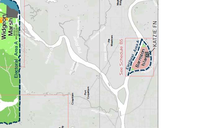
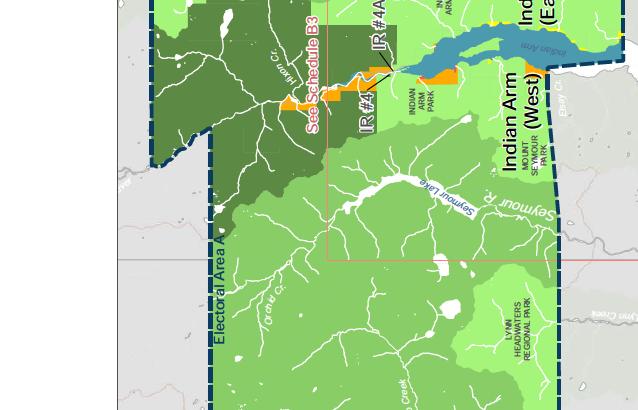

55 EA - 55


56 EA - 56


57 EA - 57


58 EA - 58


59 EA - 59

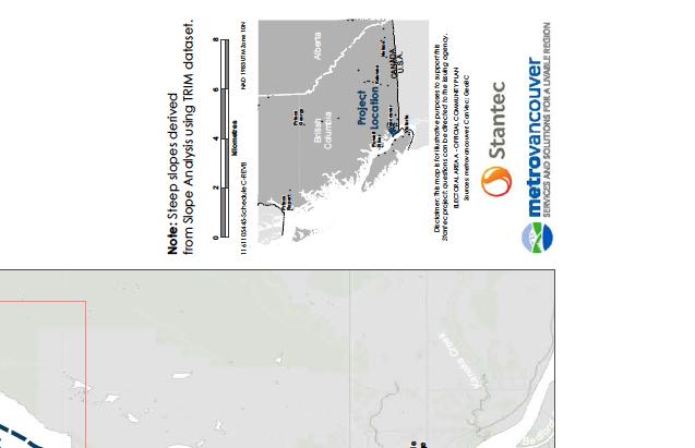


60 EA - 60
61 Metro Vancouver Electoral Area A OCP: Round 3 consultation Summary December 2016 December 5, 2016 EA - 61

62 METRO VANCOUVER ELECTORAL AREA A OCP: ROUND 3 CONSULTATION SUMMARY TABLE OF CONTENTS 1.0 INTRODUCTION WORKSHOP FORMAT INDIAN ARM/PITT LAKE/BOULDER ISLAND/CARRAHOLLY POINT WORKSHOP DISCUSSION HOWE SOUND COMMUNITIES WORKSHOP DISCUSSION BARNSTON ISLAND WORKSHOP DISCUSSION... 8 LIST OF APPENDICES COMPILED FEEDBACK RECEIVED EA - 62
63 METRO VANCOUVER ELECTORAL AREA A OCP: ROUND 3 CONSULTATION SUMMARY December 5, INTRODUCTION Metro Vancouver, with the assistance of Stantec Consulting Ltd., is undertaking the development of an Official Community Plan (OCP) for Electoral Area A (excluding the University of British Columbia, University Endowment Lands, Passage Island, and Bowyer Island). A third round of community consultations with Metro Vancouver Electoral Area A residents within the OCP s coverage area was held in November A public draft version of the OCP (dated November 7 th ) was posted to the Metro Vancouver Electoral Area A web page prior to the workshops and copies of the OCP draft were distributed to each attendee. Community members who were unable to attend the workshops in person were encouraged to review the draft OCP online and submit comments through an online feedback form posted to the Metro Vancouver Electoral Area A web page. The objective of this third round of engagement was to present the draft OCP (November 7 th version) and highlight the key policies that reflected the major issues identified by the communities through the first and second consultation rounds (held in June and July 2016). Community members were given an opportunity to provide feedback on the written policies and to confirm the policy directions of the OCP. This summary report notes the major discussion items raised at each community workshop, as well as feedback received through . Notification of the third round of community engagement workshops was sent via to residents subscribed to Metro Vancouver s Electoral Area list and a postcard was sent via letter mail to all residents and property owners in the OCP Area. Metro Vancouver staff also distributed notices of the community engagement workshops to neighbouring municipal councils inviting their participation in the OCP process. Representatives from several agencies, including Port of Vancouver and the Ministry of Transportation and Infrastructure, were also invited to attend the workshops. 1 P age EA - 63
64 METRO VANCOUVER ELECTORAL AREA A OCP: ROUND 3 CONSULTATION SUMMARY December 5, 2016 Table 1 below lists the details of the three engagement workshops held in November. Table 1: Community engagement workshop details and attendance Community Workshop details # attendees # of feedback forms received Indian Arm, Pitt Lake (west), Boulder Island, Carraholly Point * Howe Sound communities (includes Ocean Point, Strachan Point, Montizambert Wynd) * Barnston Island Monday November 14, 2016, 6:30 8:30PM, Port Moody Arts Centre Appleyard Room, Port Moody Tuesday November 15, 2016, 6:30 8:30PM, Gleneagles Community Centre, West Vancouver Wednesday November 16, 2016, 6:30 8:30PM, Tetoten Community Centre, Barnston Island (hardcopy and online) *although these areas are geographically diverse, workshops have been grouped together for logistical purposes. Residents from each area were not only encouraged to think about issues facing their immediate surroundings but also to consider the larger area. Residents who were unable to attend the workshops were invited to provide feedback by or through the online comment forms. In total, 6 residents provided comments and no residents provided comments via the online feedback form. Compiled comments can be seen in Appendix A. From the feedback form responses, Table 2 shows the proportion of respondents who feel their top priorities and concerns were reflected in each of the 6 Core Themes of the draft OCP. Table 2: Consent of 6 Core Themes in the draft OCP Meet governance responsibilities 77% 23% Manage access 60% 40% Ensure safety for residents & property 87% 13% Ensure reliable services 63% 38% Manage land development Protect natural assets & resources 94% 88% 6% 13% 0% 20% 40% 60% 80% 100% Yes, my priorities and concerns are reflected in OCP No, my priorities and concerns are not reflected in OCP 2 P age EA - 64
65 METRO VANCOUVER ELECTORAL AREA A OCP: ROUND 3 CONSULTATION SUMMARY December 5, WORKSHOP FORMAT The format for each workshop was consistent. In general, Metro Vancouver and Stantec staff took minutes to briefly discuss the role of OCP for the Area and the community consultation process that has steered the policy directions in the draft public version of the OCP and highlighted the key policies and land use designations for the Northern Wilderness areas and for each sub-area community. Various maps of each sub-area were made available at each table: land use designations, hazardous lands and ecologically sensitive areas. An open plenary discussion was held for minutes to allow residents to build on any issues they heard about, to voice any last thoughts, and provide feedback on the drafted policies and the draft OCP maps. Optional feedback forms were handed out to each resident to fill in and return. 3 P age EA - 65
66 METRO VANCOUVER ELECTORAL AREA A OCP: ROUND 3 CONSULTATION SUMMARY December 5, INDIAN ARM/PITT LAKE/BOULDER ISLAND/CARRAHOLLY POINT Staff/consultants in attendance: John Steil (Stantec), Charling Li (Stantec), Tom Pearce (Metro Vancouver), Marcin Pachcinski (Metro Vancouver), Maria Harris (Electoral Area A Director). Meeting attendees: 44 attendees counted, with 27 signed in. No residents from Boulder Island or Carraholly Point attended the workshop. Several residents from Pitt Lake East (outside of the OCP area) also attended the workshop. 2.1 WORKSHOP DISCUSSION Trees Community members wished to clarify whether the general policy on trees (Policy 5.1.4) applied to hazard trees located on private properties and whether this was a new regulation being added through the OCP. The planning team clarified that this is not new regulation, the Province has guidelines on how to manage hazardous trees on private property and the intent of the policy was to protect the overall forested character of the OCP area. The planning team will clarify this policy in the next draft. In relation to tree removal for viewscape protection, the community would like to see more clarity in the policy about whose viewscape is being protected and for what reason. For example, clarity is needed to describe whether the viewscape from the water to the forest and cabins or the viewscape from private properties is driving the direction of this policy. Commercial land use designation Community members affiliated with properties that have been designated as Commercial on the land-use maps in Pitt Lake and Indian Arm were concerned that this would impact their future property tax assessments. The planning team explained that this designation was meant to reflect the existing uses on the land and it is not expected to impact future property tax assessments. The planning team will review the definition of the commercial land use designation for this sub-area. Land-to-water access Community members from Pitt Lake remain concerned over the condition of the docks at Grant Narrows park as it is their only land-to-water access point (Policy 5.5.7) They are concerned about dock safety, poor lighting and parking conditions and would like to see more clarity in the OCP about how Metro Vancouver can help facilitate improvements here. 4 P age EA - 66
67 METRO VANCOUVER ELECTORAL AREA A OCP: ROUND 3 CONSULTATION SUMMARY December 5, 2016 Environmental assessments Community members questioned what general policy on environmental assessments (Policy 5.1.2) entailed and when they would be triggered as the language in the policy seemed to imply that all building permits would require environmental assessments. Community members interpreted environmental assessments to mean anything from geotechnical, stormwater, septic, water access, wildlife impacts, etc., and requested more specificity. Solid waste Community members discussed garbage collection services for the sub-area and questioned why the policy was not specific about Metro Vancouver s role in providing this service (Policy and ). The planning team explained that if residents desired garbage collection a service area agreement would need to be drawn up and voted on by residents, and be paid through a user-pay system. The planning team noted that Metro Vancouver is currently in the process of facilitating a one-time garbage clean-up for the sub-area. General comments Community members were in general concerned that this OCP was adding new regulation, for example, for docks (Policy 5.2.4), archeological assessments (Policy 5.2.3), septic safety (Policy ), water monitoring (Policy 5.3.2) or greenhouse gas management (Policy 5.1.3). The planning team clarified that no new rules were being added through this OCP for existing residents. Where some policies may appear to be new to residents, they are existing rules and regulations set by other agencies and authorities having jurisdiction. The OCP points out where these policies are in the OCP they are intended to raise awareness among residents. In most cases, these regulations would only apply if a residents seek a change to their properties through redevelopment. In such situations, residents are encouraged to contact Metro Vancouver for assistance to get information about applicable regulations. Specifically, the general policy for greenhouse gas management (Policy 5.1.3) is meant to demonstrate alignment with other governing policies and legislation; Metro Vancouver has incentive programs to support greenhouse gas reductions consistent with regional and provincial targets but are not introducing new regulations for the OCP area. Following the meeting, several residents requested (via ) that Metro Vancouver schedule an additional public meeting for issues raised in the Nov 14 meeting. Residents encouraged representatives from the Province, Katzie Band, and the Pitt River Boat Club to attend such future meeting. Another respondent welcomed tighter regulation and enforcement. 5 P age EA - 67
68 METRO VANCOUVER ELECTORAL AREA A OCP: ROUND 3 CONSULTATION SUMMARY December 5, HOWE SOUND COMMUNITIES Staff/consultants in attendance: Lourette Swanepoel (Stantec), Charling Li (Stantec), Tom Pearce (Metro Vancouver), Marcin Pachcinski (Metro Vancouver), Maria Harris (Electoral Area A Director). Meeting attendees: 11 attendees counted, with 8 signed in. No residents from Ocean Point were present. 3.1 WORKSHOP DISCUSSION Future land use and development Community members discussed whether there are any development plans along the Howe Sound area that might make additional basic services (drinking water, fire protection) available to existing residents. The OCP currently reflects non-support for further development and densification along the area through subdivision (Policy ), based on the inability of Metro Vancouver to provide basic services for any new residents. However, should a change of governance occur (Policy 5.6.8) where some communities incorporate with adjacent municipalities who can provide for basic services, the OCP would no longer apply. However, the planning team noted that additional polices such as the Metro Vancouver Regional Growth Strategy (RGS) applies to the Howe Sound sub-area and the current RGS does not expect growth in this area. In general, feedback from residents from previous consultation rounds indicated that development is only desired if it can sustain new basic services for existing communities. Otherwise, residents did not want to see additional development given the existing constraints with drinking water access, traffic impacts, geotechnical challenges, etc., and a desire to preserve the remote character of the area. The OCP policies may need to be clarified further to underline the reasons for non-support of future development. Future plans for Howe Sound One community member inquired about Metro Vancouver s position on the Woodfibre LNG project being planned near Squamish and was concerned about the environmental impacts on Howe Sound as a whole. Another community member had a similar inquiry about the current discussion for a Sunshine Coast-Lower Mainland Highway connector being proposed and was concerned about the potential impacts of traffic for those living within the Howe Sound subarea of Metro Vancouver s jurisdiction. For both projects, Metro Vancouver staff are working with the relevant agencies to provide feedback but currently the Metro Vancouver Board of Directors do not have an official position on either project at this time. Metro Vancouver will remain involved in these discussions to represent resident interests. 6 P age EA - 68
69 METRO VANCOUVER ELECTORAL AREA A OCP: ROUND 3 CONSULTATION SUMMARY December 5, 2016 Trees Based on feedback received from the Indian Arm/Pitt Lake meeting, the Howe Sound community was asked to provide input on the general policy on trees (Policy 5.1.4). Community members indicated that in their context, tree protection is important for the preservation of views, such as in the case of logging or forestry that would remove significant forests. More relevant for this community is the role of trees in maintaining soil stability. As this community is built on challenging slopes, tree removal may destabilize soil, leading to slope erosion which can become safety hazards and cause property damage; the OCP policy should reflect these concerns. 7 P age EA - 69
70 METRO VANCOUVER ELECTORAL AREA A OCP: ROUND 3 CONSULTATION SUMMARY December 5, BARNSTON ISLAND Staff/consultants in attendance: John Steil (Stantec), Laura Trudell (Stantec), Tom Pearce (Metro Vancouver), Marcin Pachcinski (Metro Vancouver), Maria Harris (Electoral Area A Director). Meeting attendees: 10 attendees counted, with 10 signed in. One member of Katzie First Nation attended. 4.1 WORKSHOP DISCUSSION Access Community members are clearly exasperated about ferry access. A main issue is the size-limit for vehicles on the ferry deck. Firstly, this prohibits Surrey fire department pump trucks accessing the island, thereby restricting the potential for fire-protection to the island and reinforcing the need to review emergency protocols (Policy 5.4.3). Secondly, it prohibits bulky farm equipment (e.g. manure spreaders, well drillers) from fitting on the ferry and backing off the ferry. Generally, residents want improved safety around ferry activities. Another main issue is the number of vehicles fitting on the ferry deck which causes consistent and frequent long waits. Further issues include limited delivery services; unreliable access for crucial products for agriculture; deterring potential customers. Residents voiced several potential solutions to remedy the current ferry access, and although the OCP does not govern ferry access, Metro Vancouver provided residents with relevant MOTI contact, encouraged residents to voice their concerns with MOTI representatives, and offered to be a coordinator for meetings between MOTI and residents. Shoreline Erosion Community members were concerned about controlling the continuous shoreline erosion that threatens flooding of their property and working farms. Erosion is considered to be accelerating due to increased boat traffic, larger and faster vessels causing larger wakes, and fewer logbooms to protect the shore. Support for armouring the shoreline with riprap (Policy ) was a common conclusion. Even though it is unlikely that the Dyke commission would fund for riprap supply, it would be beneficial to follow up with the Province to implement the solutions stated in their 2012 (Policy ). Although the ALC is opposed to stockpiling, the OCP has a policy (Policy #5.4.19) to allow for it. The planning team mentioned that generally the OCP ought to follow the ALC regulations, this 8 P age EA - 70
71 METRO VANCOUVER ELECTORAL AREA A OCP: ROUND 3 CONSULTATION SUMMARY December 5, 2016 issue may need to be recognized and considered by the ALC for circumstances such as this when stockpiling (riprap) is required to protect the agricultural land. Farming Viability Resident farmers advocate the importance to maintain farming viability on Barnston Island and are in support of the established OCP Policy It is understood that operating a profitable farm on a ferry-accessible island is more expensive due to increased transportation costs, and that it is harder to attract workers who are discouraged by ferry wait times. Metro Vancouver will pursue the possibility of starting a joint study with the ALC and Ministry of Agriculture to examine the vision and viability of farming on Barnston Island. Subdivisions within the ALC framework A few residents at the meeting inquired about subdivision within the ALR and the OCP policy limiting subdivision (5.2.44). It was explained that this OCP policy is in line with ALC regulations, to encourage the agricultural land-use because larger lots are more conducive for these activities and smaller lots are more likely to be taken out of productive agriculture. The planning team will follow up with residents after they research the ALC framework regarding subdivision. Biking and Tourism Barnston Island is advertised as a biking destination. Community members recognize the draw but have safety concerns around the shared-use of the Dyke Road wherein a separate bike lane (Policy #5.5.13) would be welcomed. While specific details about funding (e.g. Provincial infrastructure funding), land expropriation, specifications (off-road, additional lane) are yet to be finalized, concerns for safety for pedestrians, drivers and bikers were universally acknowledged. Similarly, leisurely tourists visiting the island also pose safety concerns. Residents are anxious about the mix of agriculture and tourism activities. Nevertheless, agritourism presents an economic opportunity for residents and farmers to sell products (e.g. honey, eggs, meat) and tourism might be a potential funding source for dyke reinforcement. Increased traffic is generally unwelcomed and MOTI should be required to enforce parking restrictions along Dyke Road (Policy ). 9 P age EA - 71
72 METRO VANCOUVER ELECTORAL AREA A OCP: ROUND 3 CONSULTATION SUMMARY December 5, 2016 COMPILED FEEDBACK RECEIVED 10 P age EA - 72
73 Policy # or Map # Map A2 Community Howe Sound Strachan Point Map A3, B3, C3 Indian Arm N/a Relevant pages Comment Appendix A COMPILED FEEDBACK RECEIVED Feedback from Transcribed Workshop Notes and s Map A2 provides for identification of Community Watersheds. Strachan Pt. residents obtain domestic water, under Provincial licence, on a community basis, from a well North of Charles Creek and East of the rail line. Director Drew from Belcarra who has written a book on Indian Arm noted the placement of Helga Bay he thinks maybe it should be the next bay south (there are two bays very close to each other but both go by Helga Bay ). So we will probably switch the order of where, East of Croker island and Helga Bay appear on the Indian Arm map Pitt Lake vision Haiku Pitt Lake 11 I propose: The region's border gives way to nature's frontier. Pristine and unforgiving - our playground environmental assessment GHG management Pitt Lake 16 This must be clearly defined or removed. What is the scope of the assessment? What is the goal? If items are not to current building codes who would pay for upgrades? Pitt Lake 16 If my property is boat access only and I use wood and propane for heat and cooking, how does this impact me? If it is generic then why put it in? trees Pitt Lake 16 Many trees must be removed for safety especially hemlocks. MV cannot regulate this unless they want to be responsible for trees and branches damaging property or harm to humans Archeological assessment Pitt Lake 18 Many properties are on an alluvial fan so they have layers of gravel deposited recently by hydraulic action. This general statement must be specific because why would it apply to these types of areas? Docks Pitt Lake 18 Define "Support access to private docks...". Any regulation of docks MUST be discussed directly with the cabin owners. This is a critical point that may require financial assistance between MV and the cabin owners should regulations be proposed Land use Pitt Lake 20 Schedule C-4 showing steeps slopes is wrong. Flat areas have been highlighted and the steep slopes were not. Please revise to show actual geographical features housing size Pitt Lake 21 What size is acceptable? housing character Pitt Lake 21 Define small scale and character with respect to each area tourism/visitors Pitt Lake 21 Please define how this will be managed? onsite wastewater Pitt Lake 22 This was not regulated before and requires direct discussions with all cabin owners. Please see my previous comments water monitoring Pitt Lake 22 The Debeck drinking water system is private. What does this mean to private systems? Who will pay for changes? MV does not own the infrastructure solid waste Pitt Lake 23 Please define and expand on this idea flooding Pitt Lake 23 Please explicitly define how this affect Pitt Lake residences? Is diking the foreshore or raising building elevations required? How will this impact cabin renos? Has MV undertaken a flood management study to model impacts and predict flood levels? septic safety Pitt Lake 24 This is not feasible due to the remoteness and cost. Most cabins are single family and seasonal usage. Simple outhouse facilities are ideal. Please remove comment or provide owners with a MV sponsored alternative land-to-water access Pitt Lake 26 Years ago MV sold Grant Narrows to the Kaztie. Service has reduced and crime has increased. Will MV repurchase and operate the boat launch? communications Pitt Lake 27 Use all medias: mail, info workshops, etc. The Pitt River Boat Club may also be used as a distribution engine. General General How are existing properties affected by the OCP document? Marcin explains grandfathering process and that the OCP is not applicable unless existing property owners are looking to redevelop on their property or subdivide, in which case the laws and policies in effect at the time would take place. General General Port Metro Vancouver has changed its name to Port of Vancouver? OCP to reflect this change to be consistent. General General Indian Arm Park has a FN name which should be reflected in the OCP: Say Nuth Khaw Yum Provincial Park General Pitt Lake N/a Is the 8 ha lot limit for Pitt Lake (W) consistent with the rules on the East side of Pitt Lake? Marcin responded he didn't know. General Indian Arm N/a Pitt Lake Resident asked about 'no trespassing' signs by the IR at the north of Indian Arm where IR #4 and #4A are, and beyond. Resident questioned whether these signs are legitimate and whether the dock there is public or not. It has been used as a public dock for many years but now there are 'no trespassing' signs on it. Marcin is not sure but explained that lots on Indian River are owned by First Nations and there was a history of forestry and an old forestry service road there. why does this policy exist re: GHG management and how does it affect residents who boat up to their properties and burn wood and natural gas, if carpool/boatpool and other strategies are not an option. Planning team explained that this is to demonstrate compliance with the RGS and provincial legislation, that this policy does not introduce new regulation for the area, and that MV has programs to support/encourage/incentivize lower GHG emissions like the wood stove exchange program. But this does not mean MV will be introducing new requirements for GHG reductions, only from a supporting role. Land use maps land to water access Environmental assessment Indian Arm Pitt Lake General 16 What are the implications of the Land Use maps designating some areas like Clementine Creek as commercial use, would this impact how BC Assessments would view the property value of the land and lead to an increase in property tax for owners? Planning team explained that the intent of this policy is to recognize existing uses of the area and do not expect the land use designations to impact tax assessments. Residents thought the objection is with the term 'commercial' and 'marina' which might imply higher value potential uses of the land which might impact tax assessments and lead to property tax increase. Some thought the existing yacht clubs there aren't really to be considered commercial but more like communally owned properties because of the membership requirement? Resident emphasized the importance of Grant Narrows Park as their only access to their water properties and that dock decay/rotting keeps getting worse, what is MV going to do about it. Marcin explains that MV's role is to advocate and work with FN. Maria Harris pointed out that the wording 'work with appropriate agencies' might need to be tightened so as to not raise expectations as to what MV can actually do. Resident wanted to get assistance from someone (MV?) re: the Grant Narrows dock issue but not sure who Katzie FN would be accountable to for doing anything to improve the docking situation. Marcin pointed out that MV would need to work with Feds or Provinces (forestry or Parks?) to sort this out and this will be an on-going working issue. Resident questioned what 'environmental assessment' meant, whether it was specific to stormwater management. From the Pitt Lake context, the wording makes it seem like any changes to building footprint, however minor, would trigger stormwater management review which in their opinion is not appropriate or feasible. Resident wants more specificity about what environmental assessments are being referred to and when it would be necessary. Marcin clarified that this would be in the case of subdivision or rezoning, not building permit stage. The key intent for this policy is for responsible development to take place. Resident pointed out that in general their community is using low-impact development strategies already anyway. Another resident wanted to know whether geotechnical assessment meant the same as environmental assessment. Planning team responded no, they are separate issues. EA - 73
74 5.1.6 trees General 16 Resident from Pitt Lake asked about his specific context where the area is mostly a 2nd growth hemlock forest which present hazards in windstorms and wanted to know whether this policy meant new regulation is being introduced and that residents would need to apply to some authority (MV or Province or other) in order to remove what they consider hazard trees from their property. How are hazard trees defined in this case? Marcin explained that this policy does not apply to hazard treets and that Province has guidelines on how to determine hazard trees and that future EAA bulletins or newsletter could include information on these guidelines for residents' information. Marcin again emphasized how this OCP differs from typical OCPs in that new new development permit areas are being introduced which would typically add regulations. Another resident also pointed out trees as fire hazards as part of the need to self-manage interface wildfires and asked how this policy applied to fire hazard trees. Maria Harris pointed out that rewording the policy as to 'encourage forested character of the area' might be better suited to convey the meaning of the policy, and to point out the difference between hazard trees and trees that are being cut down for 'viewscapes' only. Maria also pointed out how 'viewscapes' can be interpreted differently, whether it refers to the view from the water or some resident's private view from their dwellings - this is to be clarified Archeological assessment General 18 Resident wanted to know whether this policy applied to Pitt Lake, specifically their area which is an alluvial fan where it does not seem likely there would be anything of archaealogical value because it is constantly being washed out by hydrogeologic action. Resident asking for more clarity about whether this policy should apply to Pitt Lake. Another resident pointed out the high cost of archeological assessments and when that would be required. Marcin pointed out that this was added in to comply with Provincial regulations that are already existing (not new regulation), that local governments are required to check new building/development applications against the Provincial database of possible archeological sites that would trigger an archeological assessment. Another resident inquired whether this database/map was publicly avaialble and Marcin explained it is not because the Province does not want people to know where these potential sites are and dig them up and do damage. Some residents expressed annoyance that is information is not being made public by the Province. Marcin emphasized again that this is not a new requirement and that the OCP just needed to mirror Provincial regulation in this regard. One resident asked about the arch assessments that were already done in Indian Arm when the Province was considering leasehold agreements and whether leaseholders would need to do them again if nothing is changing, and whether that information is available. Tom responded that MV has those arch assessments on file and can provide information on specific lots if residents inquired and there would not be a requirement to assess again. Marcin/Tom emphasized open lines of communications to the residents that if they wanted to know about their property, whether they are redeveloping or not, they can contact MV and inquire about archeological information or other information. General General N/a General Indian Arm N/a Resident wanted to know why they have to pay school taxes when there are obviously no school services for this OCP area, and if they are already paying these taxes through their primary residence municipalities within Metro Vancouver. Another resident commented that it's not only school tax, but also garbage, roads, policing taxes too which they feel they are not getting the services for. Planning team and Maria explained how taxation is being handled differently for Electoral Areas, and that school taxes are paid into the Provice and all properties must pay into it, even if it seems like some have to pay twice (because they have more than one property). Residents of Pitt Lake in particular pointed out there used to be an annual garbage collection for Pitt Lake that residents paid for separately and why that was cancelled, and why they are still paying taxes for garbage if they are not getting service. Planning team explained that garbage taxes are for Metro Van's garbage handling facilities in MV such as landfills, transfer stations, recycling/compost plans, and not for garbage removal. If residents wanted garbage pick up they would need to set up a service area for pick up which would be a user-pay service that would need to be voted on and in past examples (such as Barnston for fire service) would prove expensive. Maria explained that MV staff are working to do a one-time garbage clean up for Pitt Lake. Resident of Indian Arm asked whether there would be any public access to the water such as a canoe launch made avaialble in the future, for example like what is available at Buntzen Bay. A Buntzen Bay resident pointed out that there is a road access to the water near Buntzen Bay but ownership is convoluted and access is complicated land-to-water access Pitt Lake 26 Residents pointed out access issues at Grant Narrows Park re: lighting and safety and lack of garbage service. Discussion about whether it is the responsibility of Katzie to provide this. Residents wanted more specificity about safe access to boat launching facilities at Grant Narrows Park and who MV would work with Docks General 18 General General N/a septic safety Pitt Lake derelict properties General 18 General General N/a General Pitt Lake N/a water monitoring General 22 General General N/a Resident from Pitt Lake asked about what this policy on docks mean for Pitt Lake residents because their docks are on tidal waters and frequently need to be rebuilt due to weather/storm damage. Does this mean that every time docks are rebuilt they would need to meet new regulations. Marcin explained that this policy to meant to make residents aware of the Provincial private moorage guidelines and is an existing regulation already. MV is not the authority having jurisdiction over docks, it is either Port Vancouver (for Indian Arm) or Province (for Pitt Lake) and residents would need to follow appropriate regulations. Resident wanted to know when they can see the next version of the OCP and how changes will be documented. Marcin noted that the next draft will be posted and residents alerted and there will be some way to track changes. Resident from Pitt Lake pointed out the challenges related to installing/maintaining septic fields as they would be designed based on urban design guidelines that are not appropriate for rural context. Does this policy mean that existing residents and systems would need to be upgraded, and pointed out how septic fields meant more extensive power requirements to operate pumps and accessory equipment and that residents do not have access to hydroelectricity. Marcin asked what septic systems residents have and most residents present have pit toilets, not even a drywell (concrete pit), just a hole in the ground for wastes. Resident wanted to know if there were existing policy and enforcement of derelict properties and whether they can be even enforced. Tom/Marcin pointed out there is a EAA Unsightly Premises & Nuisance Bylaw (1198, 2014) already. Resident wanted to know why an OCP is needed. Marcin explained the driver of the OCP came from Barnston Island, and how EAA is the only jurisdiction within MV that does not have any basic planning policy. Maria explained the importance of the OCP consultation process and to document the issues/character of the area, and how residents desire to keep the low-impact development of the area and support for simple regulations Resident from Pitt Lake think there is more environmental damage from visitors/tourists/recreationist to Pitt Lake than from existing residents. Another resident observed that Widgeon Marsh is being treated as a garbage dump. Resident from Pitt Lake inquired how this policy factors into existing owners' water infrastructure, if this meant additional water monitoring efforts are needed. Marcin explained this policy is also meant to reflect overall land stewardship and not to add new regulations Observation from resident that he has seen MV staff and Maria go through a learning curve in the last 6 years or so and is happy with how staff have progressed but warned against how the OCP will ultimately be voted on by the MV board which may not understand the rural character of the area and have not gone through the learning that MV staff and Maria have gone through. This resident cautions that the MV Board is very political and hopes for the best outcome. Maria indicated that this OCP will go a long way to helping the directors understand the area better. General Howe Sound N/a One resident pointed out that there is low turn out from Montizambert Wynd because many have gone south as of Nov 1st, timing could've been better for this final round of engagement. General Howe Sound N/a How are sizes for rural lots defined? Marcin answered - this is specified in the zoning bylaw, which is currently set at 8 ha Water - land use designation Howe Sound 14 How is the water zone defined and what does it mean for Howe Sound? Answer: because Howe Sound (all ocean water portion) is part of Islands Trust jurisdiction so is part of their planning, not Metro Vancouver's. This designation doesn't deal with drinking water. General Howe Sound N/a General Howe Sound N/a Emergency Planning Howe Sound N/a Does Metro Vancouver have a position on the Woodfibre LNG project, resident feels this project is being forced onto residents without adequate input and consultation. Marcin and Maria indicated that Metro Vancouver's board hasn't issused an official statement or position on the project but that staff have provided feedback and comments on the environment concerns regarding this project. Does MV have a position on the proposed bridget to the Sunshine Coast. Marcin responded that this is a provincial MOTI endeavour and Province has held some information and consultation meetings in which MV staff (environmental department) have taken part in, current status is that the MLA for the area has initiated preliminary feasibility studies to look at costing and feasible options and will have costs attached to options by the end of the year. MV staff are participating in the process only. Maria added that the Mayor's Council at Translink is also aware of this issue and are discussing this; also the MV Board of directors have not taken a position on this issue but MV staff have voiced their opinions on the process. The Howe Sound Community Forum is also aware of this issue and are considering what this might mean for increased traffic along this coast given the projected growth in Squamish and Britannia Beach. What is Metro Vancouver's environmental disaster response and recovery plan as there seems to be a lack of close coordination with others, for example on potential oil spills. Marcin answered that MV has emergency plans and they are part of oil spill response consultation efforts subdivision Montizambert Wynd N/a Question from Strachan Point resident about whether water for Montizambert Wynd comes from West Vancouver and whether anyone has expressed interest in high density development in the area between MW and SP and whether that would be sufficient to bring a water system for both communities. MW resident responded that their drinking water comes from Montizambert Creek at a point before the West Vancouver system treatment. Marcin responded that no development application has been made to MV yet, but they don't expect MV to be able to provide services even if that development in that area is proposed. Perhaps amalgamation with a municipality would be entertained if development was the driver in those lots. Marcin explained that the subdivision process is not public and is only subject to adequate access and services; the current OCP as written does not support subdivision and development in the area as long as governance structure remains the same (ie MV is responsible for the area instead of another municipality. Maria questioned whether the ability to provide for services is the only limiting factor to development. Marcin raised the issue of whether growth along the Howe Sound corridor is consistent with the Regional Growth Strategy too which is another level of policy that the OCP should be in line with. A general discussion ensued as to what level of density would make service provision sustainable and Lourette suggested looking at Lions Bay as a case study because they are having challenges maintaining their fire protection services with their level of density. Maria suggested that perhaps a separate conversation needed to happen at the MV Board level on densification of the Howe Sound corridor and thought that the OCP should be clearer about where residents stand on future development, and also what is underlying the OCP's non-support of development, is it steep slopes or water access or service provide. Maria suggested that MV should be 'raising the bar' on what limits development above what other neighbouring municipalities like West Van and Squamish might consider. Lourette reflected that from the previous two rounds of community meetings it sounded like the majority of resident feedback was that the long term vision was to maintain the current character of the area, where they live by the city but are not part of the city, and that the only reason given for supporting development was if it made additional services available to residents. EA - 74
75 5.4.7 and Fire Protection Strachan Point N/a one resident pointed out that it would be nice to have fire service without having more neighbours and reflected that Strachan Point had been trying for a long time without success, and inqured whether ocean water could be used for fire protection and how that might weigh against residents' insurance premiums. For example would paying the cost of fire service balance against the additional insurance premiums residents pay and increase the value of their properties Residents's Assocation Montizambert Wynd N/a One resident of Montizambert reflected that in the past the polarization of views made it difficult/impossible for their community to get anything done, for example even in their past discussions with West Vancouver regarding amalgamation and the history of residents trying to get fire and water service Residents's Assocation General N/a Resident of Strachan Point suggested that the self-governance of Strachan Point has been crucial to getting things done for their community. For example Ocean Point has a strata council and Strachan has an elected governing body which turns over every year, but Montizambert doesn't have anything similar and perhaps that is why they have difficulty achieving community objectives and Fire Protection Montizambert Wynd N/a Montizambert Wynd resident pointed out the issue with fire protection for their community also has to do with the fact that West Vancouver did not want their fire trucks to have to back out over the bridge and that no price tag was discussed with West Vancouver because discussions stopped at that issue and Fire Protection Strachan Point N/a Strachan point residents are still interested in having some type of self-managed fire protection system General General N/a Maria suggested that the policy should be clearer about whether something is within the control of MV in order to manage expectations, for example policy language re: 'facilitation' should be clearer trees Howe Sound 16 Marcin suggested that Howe Sound residents conosider the 'trees' policy as many concerns were raised at the Indian Arm/Pitt Lake meeting, about how the policy should be clearer in defining hazard tree vs forest character. Montizambert resident suggested that trees in their community context is about maintaining slope stability. If trees are removed then soil erosion may occur and impact soil stability which is especially important since Montizambert Wynd lots are very steep in some cases 45%. Suggest that policy also include language explaining why trees are important to soil retention and erosion control which are the high priorities for this community. Potential for unintended damage if trees are removed and causes damage to own or neighbouring house stability. General Howe Sound N/a One resident thanked the planning team for liaising with residents Flooding Barnston Island Barnston Island Shoreline Erosion: One resident brought up concerns for erosion of the island, stating that it has eroded 4-50' in their lifetime; up to 8'per year with slumps and holes. It was a consensus amoung the group that protection against erosion was needed. The North/River side of the island is eroding faster. Erosion is speculated to accelerate due to 1) increased boat traffic, faster boat traffic vausing bigger waves/wakes; 2) Less log-booming to protect the shoreline. A solution brought up would be to enforce lower speed limits. The other solution would be to add rocks (armouring) along the coastime. However, the North side of the island is too deep for armouring. A representative from the FN mentioned it would cost ~1.4mil dollars to armour the reserve itself. Another source of income would be from the dyke commision who could look for grants. The cost would be split 1:1:1 province:federal:community. the dyke commision could help fund engineering report and riprap supply. It was mentioned that the Province would pay them out before funding armouring costs. one resident suggests a depot is available for riprap on the island. John says the OCP states there is a stockpile policy. However, one resident mentioned that the ALC is against stockpiling and that the ALC should be updated Marcin said the ALC needs to sign off on the OCP and that the OCP needs to work out language with the ALC. This issues needs to be recognized for circumstances as this where riprap supply is needed to protect agricultural land area. Yes, a policy to stockpile is needed. Riprap supply could also come from barge loads, anytime, while truckloads could only arrive at night. The general consensus is that dyke stability is a priority, and flooding would be detrimental. A solution is paramount. Listen up! Several residents stated that they feel their concerns are not being heard - "fall on deaf ears". This (community engagment sessions) are just a social, and nothing gets done. When problems occue, they governance panic, when the residents have foreseen issues and would be better off to be prepared. John: "This is the definition of planning!" It's good to state your opinions res: re-affirmed that this is the first OCP, so everyone should get their opinions written down. We shouldn't be too focused on the by-law. The resident questioned whether is is a platfrom to state problems or discussions for the future. It is known that if there is no money, then there will be no fix. Another resident was concerned what the OCP was for because they say Metrovancouver governs the zoning, then the OCP provides landuse within the already existing zoning boundaries. they didn't beleive in the OCP process and feels its just a clean-up, not worried about future or alternatives. Another resident adds that the OCP could be anything and feel discouraged to plan whatever they want when it's just a "clean-up document" Marcin, like John, ensures that the OCP does carry weight. The words on paper help advocate to move forward. The OCP is a formal document to voice concerns....elapsed time... one resident voiced their opinion that the OCP is static and that nothing would changed with implementing it. It would be more benificial to look forward and imagine what agriculture would look like in the future and what infrastructure would be needed....elapsed time... One resident was concerned that not all the issues were worked out yet, and that the OCP shouldn't go to final draft before another draft was issued. More residents aggreened that 3 meetings were not enough Subdivision Barnston Island Subdivision/ALC Regulations The issue of subdisivions was raised, and this brought up the issue that the island is within ALC. One resident adds that the OCP could be anything and feel discouraged to plan whatever they want when it's just a "clean-up document" John responded with yes - we have to live within the ALC restraints. Maria: reassures that the ALC is constraining but its necessary for the ALC to signoff. Yes, the island is within ALC so work within in. Marcin: Yes, the island is within ALC. The ALC is against smaller lots because larger lots are better for agribulture. long-time islander/resident: Asked what is the current ALC lot size for existing lands? Also asked if the lot size has to stay the same size or can it be reduced? Marcin agreed to get answers back to residents. Residents were pleased to get more clarification on the ALC regulations....elapsed time... One resident re-stated his interest in including some flexibility within the OCP for parcel sizes and subdivisions, Having it noted for the future in the OCP and not just what the ALC regulations permit at this time. John: It is important to find common community interest and to look into the ALC framework to see where it's flexible. Does it flexible for subdivision under certain circumstanced? Will need to work with the ALC. Barnston Island There are conflicting views from Island residents and property owners and who should have more say/influence. One resident proclaimed "I'm an Islander - you're just an owner!" Subdivision for hooked lots; 'no parking' (no stopping?) Barnston Island Biking One resident brought up the concern that gobikebc (everyone should go visit the website) promostes Barnston Island as a good place to bike, and teach your toddler to bike. On the same line, it would be a good place to teach your teenager to drive to. However, the resident is a farmer who operates heavy machinery (tractors, milk truck) on the main dyke road and is not expecting a leasurely slow biker who takes up the entire lane. Tractors can't stop quickly and there have been several close calls. Dyke road is a highway class road - and bikers don't realize that....elapsed time... A suggestion for a separate bike lane was brought up, something wider, maybe a trail or something similar to a seawall perhaps. This would separate the bikers from traffic, off-road, making it safer for everyone. It would be a nice ammenity to have 10km+ stretch of trail to bike/run/walk along the prized waterfront, along a beautiful farm lanscape. A wider road/bike land would widen into the farming land which would not be ideal. Land expropriation may be need for a fully separate bike lane. having a bike lane around the whole island would be a big project. One resident is adimate that they do not want to give up land (for farming or not) for a bike path. Another resident says that the road rigth of way is 30' but the road is only 10' wide ensuing that there's already room for the new bike lane. Tom: There is a policy in the OCP to have a separate bike lane, for safety concerns. It was suggested by residents that the Province should pay for the infrastructure, as they are already responsible for highways and access. They could get their capital money back from the attracted tourists. Perhaps by charging 50 cents/bike to cross on the ferry. EA - 75
76 Secondary dwellings; Subdivison Barnston Island Tourists Marcin: Tourists already visit the island. With more people visiting a better, more attractive ammentieies present the opportunity for the Province to rationalize paying more better access. Marcin reassured the general consensus that improved bike infrastructure improvement to avoid farmer interactions from farm vehicles, tractors. John mentioned that tourists will come so residents could capitalize on the opportunity to sell (fram) products (honey, eggs, cheese, meat). One resident (advocating for subdivisions) re-states that agro-tourism may be an incentive for smaller parcels, more buildings for botiques, selling goods, perhaps holiday accomadations. BI is in the heart of the 4 fastest growning communities, and BI has the opportunity to take advantage and bring in some extra income. (This caused a ruckus between residents of unwanted 'industrial'type vision for development). One resident responded that bikers wouldn't purchase hay to bring home with them, but meat could be sold to tourists. One resident grumbled that tourists are not welcomes, but its inevitable. Another chimed in saying tourists bring more garbage, and that's already noticeable. Not just at the parks, but along the roads aswell. The litter pick-up responsible is downloaded to the residents (while out walking their dogs with an extra garbage bag at hand). There are concerns that fast-driving tourists are dangerous around (unleashed) dogs out for a walk. Representative from the FN mentioned that with increased road traffic, the FN may consider not allowing them to drive through, but rather tourists will have to "drive around our FN". One resident mentioned that if tourists are coming anyways - they could bring money (funding) for dyke reinforcement. Maria(?) One solution for funding would be that the Regional Parks need to co-fund the bike greenway connecting the parks. Similar to 'experience the Fraser' ALR Barnston Island Farming Viability Resident farmers on the island expressed that they simply want to farm. One resident stated that if areas in the Greater Vancouver Area metropolitan areas are deemed as 'urban agriculture' allowing rooftop gardens, backyard chicken coops, and being able to legally seel goods that BI is the real deal, a real agricultural community. tourism.agro-tourism could promote small hobby farms/farmers. Farmers don't want to see the agricultural land go to waste just because of a unreliable and poor ferry access. Some farms are more independant (such as greenhouses, eggs, milk, etc. while other farms are dependant on the ferry. Farmers at this time cannot get the same value as mainland farmers (up to an extra 5$ per hay bail is absurd!). but they don't want to give up either. They are proud (up to 5th) generation farmers. At this time, farm hands have a 30-45min wait to get on the island. Farming is more expensive on the island, more challenging (due mainly to access) and this is less attractive for new people. Sure, the land may be cheap, but it's more expansive to manage. Transportation costs are higher. As it stands, farming won't be viable until the ferry is fixed. It was attested to protect the farmer, that's how farming will be protected. Farmers on the island would like the backing and support of metrovancouver, having someone advocate for them. Primarily for what they need: improved access. Maria: Restates that being precise about what residents want and need. being specific in their comments. She posed the question 'if access was right, what would farming look like?' Marcin re-questioned 'What would viable farming look like on BI?'. He restated that a study for farming viability would be appropriate, doable and benificial. To get the facts about what specifically is needed. requires a cost estimate and need for ALC information. This study would need to be in collaboration with ALC and the Ministry of Agriculture so everyone is in agreement and know the current situation Ferry Safety; Emergency Access; Fire Protection Barnston Island Access Summary: Access onto Barnston Island is horrendous and is detrimental to sustained agribulture and the overal viability of Barnston Island. Residents of 17,30, or 50 years haven't seen the ferry change. Current ferry has weight and size (54' loong, or 63' with overhang) restrictions. There are many issues around the current ferry access: 1) FedEx won't home deliver - residents need to pick up parcels on other side. 2) Farmers rely on reliable deliveries and shipments of products to keep farm productive and profitable. Farmers feel cut-off from product because trucks are delayed up to 2 hours at the ferry. 3) Customers are detered to visit the island for purchasing 4) Farm equipment (manour spreader, modern well driller) and trucks often do not fit on the ferry - and are very difficult to back off. 5) Emergency service vehicles (e.g. surrey pump truck) cannot fit on ferry, cutting it off from fire protection. 6) there are safety concerns for all vehicle types backing off the ferry. e.g. tourists are poor drivers and do not expect to have to back off/onto ferry. 7) cannot make a living as a farmer due to access -its not just from the farming nature that is a colitile industry. There were several solutions raised for fixing the current access issue: 1) ferry policies could be adjusted for: avoid first come - first served practive by introducing a priority system catering to residents over tourists, and time-sensitive deliveries; consistant with ferry operators to keep a consistant # of vehicles allowed across all crossings; stop fueling mid-day (which delays crossings) 2) Marcin suggests waiting until after the 3(?) years left on the current ferry contract, and negotiating then. 3) 24-hour access, instead of the current restricting schedule. 4) Bigger ferry, with drive on/drive off capabilities. 5) Bridge, that would need to be negotiated with log-booming activity Access (2) One resident says a draw bridge design was proposed 20 years ago (in 1995?) and would operate around log-booming activities One resident mentioned that Pros for better access would be access to police and fire protection while a Con for better access would be a potential increase in theft and vandalism. Another resident suggests that it may come to paying for increase security. For now, the ferry operators act as a type of security threshold for potential threats coming onto the island Ferry Safety Barnston Island Barnston Island Barnston Island Pitt Lake Pitt Lake Pitt Lake Pitt Lake Marcin states that it is benificial to state the desired access in the plan, just needs to be specific. Maria also posed the question of 'what is the nature of good access?', 'what does it look like?' and 'what are characteristics of good access and level of service'. Maria said that these characteristics can be described in the OCP as a footnote or perhaps an accompaning document. Marcin deferred the ferry access issue to MOTI suggesting that although Marzin (spelling?) is no longer avaialble, Cory can be involved. Tom mentioned that this issue is in the OCP for when the ferry contract gets renewed. Hunting One resident raised concerns for firearm activity on a neighbouring property. Activities such as fowl hunting are disturbing to livestock and residents. Tom remarked that as long as the acitivity is within the zoning by-law, not in a park, and further than 100m from a building then it is permitted. One resident commented that the fowl being hunted were released grain-fed pheasants. Another resident mentioned that the entire island is noted on a FLNRO map as 100% approved hunting, and had visitors ask them where to hunt. Marcin directed the residents to file their complaints with their conservation officer FLNRO representative because this falls unfer the wildlife act. The local government doesn't have legislation to enforce such a thing. Maria posed the question to the group whether the vision for the island was like "Westham Island East" with lots of farm stands, and a plesant farming atmosphere with reliable brige access. For now, best to voice concerns regarding most critical factors affecting viability of farming and living on the island, and make a wish list of hopes of what the island will be in years to come. One resident mentioned needing a "fixed link" After access will be reliable power and water resources. For now, the island's water source (from ground water wells) is full of iron. But residents don't want the city's water either because of the high cholrine content. I am a stakeholder in the OCP process for the Pitt Lake area and I wish to have an additional public meeting scheduled so that staff can clarify the comments that were raised in the November 14 meeting. Please ensure that representatives are in attendance from all other applicable governing organizations including the Province and the Katzie Band. Marcin responded by telling the resident that the issues raised will be incorporated into the revised version, the second draft, and that additional feedback would be welcomed at the time. I am a stakeholder in the OCP process for the Pitt Lake area and I wish to have an additional public meeting scheduled so that staff can clarify the comments that were raised in the November 14 meeting. Please ensure that representatives are in attendance from all other applicable governing organizations including the Province and the Katzie Band. Marcin responded by telling the resident that the issues raised will be incorporated into the revised version, the second draft, and that additional feedback would be welcomed at the time. I am a stakeholder in the OCP process for the Pitt Lake area and I wish to have an additional public meeting scheduled so that staff can clarify the comments that were raised in the November 14 meeting. Please ensure that representatives are in attendance from all other applicable governing organizations including the Province and the Katzie Band. Marcin responded by telling the resident that the issues raised will be incorporated into the revised version, the second draft, and that additional feedback would be welcomed at the time. A number of my neighbours on Pitt Lake and other stakeholders are very concerned about how far reaching these clauses are and how MV will regulate and enforce them in the future. It's clear that more work must be done to educate the project staff on how our community works so that any governance model that comes into place can be reasonable, feasible and accepted. I kindly request another public meeting with all applicable third party governing bodies in attendance including the Province and Katzie. The goal of public consultations is to gather information for local residents and stakeholders and ultimately, gain their support. Much work and clarification still remains for the Pitt Lake community. Marcin responded by telling the resident that the issues raised will be incorporated into the revised version, the second draft, and that additional feedback would be welcomed at the time. EA - 76
77 Pitt Lake Pitt Lake Pitt Lake An additional meeting with Pitt Lakers to review the revised draft would be great. Ideally, could you please invite the province and Katzie? We could have the meeting in Coquitlam in the clubhouse at the Pitt River Boat Club if you wish. Many Lakers, including myself, are members. You have echoed my concerns as the OCP being a policy document. I'm concerned that if the broad statements are not sufficiently clarified, then other documents such as the zoning bylaw will directly reference the OCP and stakeholders will have to deal with governance that is not feasible or applicable. Its my understanding that third round of public consultation was the first to see the draft document. I'm not sure that stakeholders were aware of how soliciting their ideas for general themes of the Lake would impact them on hard line items such as drinking water, wastewater, trees and docks. Granted some of these are governed under other bodies but this document ties everything together. The OCP must show how MV plans on regulating these items because every cabin is not in compliance in one form or another. The OCP must be detailed so that when you move on and a cabin owner wishes to take out a building permit they are not burdened with unreasonable requirements to fulfill. Other cities in MV have had 125 years to develop from the pioneering equivalent that exists on Pitt Lake. What works in urban centres would be difficult to achieve on Pitt Lake. MV is our local government and all we want is our local government to take the time to understand us. A number of my neighbours on Pitt Lake and other stakeholders are very concerned about how far reaching these clauses are and how MV will regulate and enforce them in the future. It's clear that more work must be done to educate the project staff on how our community works so that any governance model that comes into place can be reasonable, feasible and accepted. I kindly request another public meeting with all applicable third party governing bodies in attendance including the Province and Katzie. The goal of public consultations is to gather information for local residents and stakeholders and ultimately, gain their support. Much work and clarification still remains for the Pitt Lake community. Please carry out this request. Marcin replied and explained that the OCP do provide general direction on a broad range of isses, but as a policy document it does not introduce new regulations or enforecement. Marcin responded by telling the resident that additional feedback would be welcomed after the second draft is available. Self regulation and enforcement within the camp, has never worked, in the last few years, some of the issues which you are addressing and others, including, docks, building, potable water, sewage, tree cutting, burning and refuse dumping on the MOT right of way, have resulted in physical confrontations. Therefor my wife and I welcome regulations and hopefully "enforcement ". Subject: pitt directory with details about 911 registration on west side of lake 1) 911 registration - west side of the lake is now registered with 911 MetroVancouver has numbered all the cabins on the west side of the lake so that if you follow their numbering system and you are able to use a cellphone, you will be able to call 911 and they will actually know where to send someone to help you... I know that is alot of ifs but it is a good start and I appreciate the effort that metrovancouver went through to get that done (sorry east side of the lake - it doesn't apply to you ) Here is a link to the map of the west side, if your eyesight is good enough and you can make out your lot please have people from each bau on the west side let me know how the 911 assigned cabin number relates to our existing numbering system. 2) Official Community Plan meeting yesterday Several Pitt Lakers attended the 2 hour presentation regarding the OCP for the West Side of the Lake. It is essentially a community plan that can hopefully have some infliuence with respect to the zoning bylaws for the West Side of the lake. For example the OCP is proposing that we be allowed to add a guest cabin to our property (which I don't think is currently included in the existing zoning bylaws). Yesterday was already the 3rd meeting and I don't really know if there will be anymore after this. I expect not although the metrovancouver electoral A folks at the meeting said it could certainly be possible if there was a need for one. I don't know if it is possible but in hindsight it might have been a good idea to have a meeting at the Pitt river boatclub to deal solely with Pitt Lake issues. Unfortunately I never thought of it til now. Since things that happen at Electoral A can significantly impact your lake property I would recommend you get on their mailing list. But to do that you have to sign up yourself. If everyone agreed in theory I could just hand over all my s to the Electoral A folks but since many people don't want their s handed out I am not going to provide your even if you ask me to. If you want to be on the electoral area A list for information you need to take the time and effort to click on the link below and provide your information... The Pitt Lakers at the meeting asked a lot of questions (Rob R in particular) and asked to have a lot of things clarified. Metro Vancouver is going to incorporate everyone's comments to the best of their ability and then send out the changes. You still have time to look at the community plan that I sent out and send in comments of your own- just don't take too long. If you don't have the anymore here is the link to the report which you can download and read (remember that it is the 3rd draft and hasn't yet incorporated any comments from yesterday's meeting.). Some details from the meeting I am not going to talk about everything in the meeting but just touch on a few things. And if I forget some important things that were discussed, you will have to get that info when etrovacouver send out their comments /and edits to the Community Plan (hopefully in the near future). stuff that was discussed (that I remember) Concerns about being able to cut down trees. - suggested tossing out the item referring to discouraging people from cutting down trees (for pitt lake at least), The logic being that the west side of pitt lake is full of trees and there are only 75 or so 100 ft wide waterfront lots spread over about ten miles of lake shore. It is more important to ensure trees don't fall on our cabins now that the hemlocks are older and dropping all over the place, and to also provide proper fire guards since we have no fire protection, and we had a forest fire about a mile north of Debeck Creek this past summer. So summing all that up it is important to have the freedom to cut down trees on our property. Concerns about septic rules and possible future rules. Well if you aren't building anything new, you should be okay. If you build beyond your existing footprint you may have problems. But given that in general the cabins are used primarily in the summer which translates into a rather small environmental impact perhaps there is some wording that can be put in the OCP to reflect that the sanitation impacts are very low due to the low usage and small cabins. Concerns about the structural condition of launch facilities at Grant Narrows, the condition of the road to Grant Narrows, security etc... I have asked to see if we can sort out if it is still the province that is responsible for maintenance of the docks and providing funding for fixing the docks and how the Katzie management of Grant Narrows launching facilities ties in with the province's responsibilities. Metro vancouver doesn't have any say on this but they may be able to provide some contact information for us. Long ago I used to deal with someone in the province but that was long ago and I don't have a contact anymore. concerns about getting better or in many cases any cell service at all.. (at Debeck I bluetooth my phone to an inreach explorer < and am able to send texts and receive texts using the irridium satellite system. for around $30/month plus about a buck to send or receive a text. And it works 24/7. It also has an emergency button that you can press and it will send your gps coordinate and all the relevant authorities will know where to go to rescue you and can even text you.). Concerns about dock regulations. Again metrovancouver doesn't have any Pitt Lake 7 Subject: pitt directory with details about 911 registration on west side of lake In the past, I've done a number of public consultations in the late evenings for BC Hydro with respect to flood issues and water planning issues and remember that those activities made for long days after already spending a full day at work. So I really appreciate your efforts and have some idea of the efforts required, which often may not be fully appreciated. I sent an out to everyone on the lake a few minutes ago (it is below) and also tossed up the electoral A info about the OCP on the pitt river boat club< My main interests in the short term are: 2) having our "marine watch - Pitt Lake Directory (enclosed) be in alignment with the 911 numbering system. I'll have a look at the map that I got yesterday and perhaps add a column to my pitt lake phone list so that the cabin owners know how to identify our pitt lake directory cabin designation with that of the 911 map. If there is anything regarding electoral area A that you would like me to add to the pitt lake directory (contacts, information, etc) please let me know.added stuff about the 911 registration to page 7 of the enclosed directory. 3) If you have any descriptive information that is relevant to explaining anything about the 911 numbering system let me know and I can add a paragraph to my directory document. I have added a page to the directory (page 7) that discusses the 911 stuff and also encourages people to get their s onto the electoral area A list. 4) If possible, I would appreciate a contact (provincial perhaps? ) so that we are able to raise our concerns regarding the state of the docks and road to the Grant Narrows boat launch. I have been assuming that the provincial government is responsible for the docks and that that the Katzie's are responsible for managing the boat launching/parking activities. Several years ago I believe I had a contact in the provincial goverment but I think they moved on to a different position and that was the end of it.5) There are often derelict vessels in pitt lake and in the pitt river and if you could provide any insights into who is actually responsible for dealing with these vessels that would be helpful. Currently there is a boat Mostly submerged in a channel of Pitt Lake (has been their for more than a year now). This is not only a navigation hazard but also an environmental hazard and I am honestly astounded that there does not seem to be any government entity willing to take responsibility for dealing with this.the RCMP that patrol the lake advised me that they contacted the Coast guard but that the coast guard weren't willing to do anything about it. It is an obvious and very real hazard and actually is on the side of the channel (apparently fixed in the mud) but given that it is floating vertically, there are times during the tidal cycles that it is slightly protuding abover the water and at other times completely submerged. It is in the navigable portion of the channel and could easily be "set free' by the winter storms. Cabin owners go up to their cabins all year long and although the traffic is much less in the winter months, the unfortunate fact is that if a boat struck this vessel it is not unlikely that the boat would sink and that their would be a fatality if anyone ended up in the water. I will have another look at the OCP this week and think about the comments made by my Pitt Lake neighbors and hopefully talk to some of them and see if I can provide any useful comments by early next week. I added a post and a couple links to electoral area A on the pitt river boat club < website and will forward any comments or any correspondence you want to have distributed to the Pitt Lake folks. (I think I have 95% of the Pitt Lake and Pitt River folks in my list). One last thing. Is there anyway to get a large Pitt Lake reference map (giant size - so you can see the individual cabin numbers) so that we could put it up at the pittriver boat club. The RCMP launch from our boatclub and so do the search and rescue guys so if we had a huge map (that allowed you to read the informaton on it) it would be useful for the RCMP or search and rescue to be able to have a quick look at it before they headed out. EA - 77
78 Meeting Date Community 3a) Protect natural assets & resources 3b) Manage land development 3c) Ensure reliable services Appendix A COMPILED FEEDBACK RECEIVED Summary of Feedback Form Responses 3d) Ensure safety for residents & property 3e) Manage access 3f) Meet governance responsibilities Nov Indian Arm y y n/a y 4) Opportunity to adequately express opinions 5) Specific policy comments minimum regulations is a good goal. 6) Other issues/questions Nov Indian Arm y y y y y N: please keep it simple y Nov Indian Arm y y y y y: only have wter access y Nov Indian Arm y y y y y y y Nov Indian Arm y y y y y y y none not at this time 3.1 Pitt Lake visions statement - don't agree that residents feel protected against threats from fire + property crime, and that emergency response procedurs Nov Pitt Lake (West) y y y y y y n: Grant Narrows has become completedly unsave, ie Docks, Nov Pitt Lake (West) y y n: needs improvement y Ramps y y Permit fees of 3% of assessd land value on leased lands seems out of sync and frankly quite unfair when compared to tax amounts Nov Pitt Lake (West) n: As per director's comments, probably best to reword 'tree section, such that it refers only to "commercial activities, to ensure this doesn't place constraints on cottage residential. y: but add in ability for guest cabin N: Forward 911 information for Pitt Lake so those cabin owners with cell coverage can utilize the 911 service Y N: Clarification of who is 'owner' of Grant Narrows, is it Provincial Government with Katsie acting as operator or is Katsie also 'owner'.? Y: But probably best to submit an to summarize things, rather than filling in this form. Perhaps remove "tree claus" or make it specific to commercial logging or simply exclude cottage residential. Nov Pitt Lake (West) y y N: does not apply to our area y y y y Nov Pitt Lake (West)? y Nov Pitt Lake (West) y y N: we look after our: Drinking water, wastewater, waste, do not require cell/internet service Y for cell service. N: reliable basic services are not avail now and will not be in foreseeable future. N: We look after our safety + deal with the hazards N: not part of our situation Not sure yet Y Y: You can try N: We don't have roads. Katzie supposedly manages water access & parking at Grant Narrows Y Y 3.1 Pitt Lake: we don't have any fire protection except our own garden hoses. We don't have pristine water for drinking either creek or pumped from the lake that cannot be trusted for Nov Pitt Lake (West) Y Y y (Solid waste circled) y y y Nov Pitt Lake (West) N: verbiage is not specific enough N: each land owner should be advised if their land is subject to archeological assessment. This secrecy is offensive. Y Y Y N N: report should have been ed to us - you have our . We shouldn't have to search for info. Insufficient time to discuss issues. Too much time spent on background. Separate Pitt Lake & Indian Arm meeting Nov Pitt Lake (West) In theory, the protection efforts are appreciated. Clearly, this language needs to be refined as to intent. Though you know the intent of the phrasing, it must be clear to the person who follows you so that the extent of private property interference is not able to be exploited. Again, clear language so someone does not over-interpret the rules & regulations. N: Without the cell service - fire protection & police & other basic services are not available to residents without easy access: way too much waste gets dumped into the lake & in the woods. N: Comments above. N: Unable to truly help with parking or safe boat access N: Unfortunately - no access to help to increase all service for communication or any way to regulate/insist safe boat access or safe parking. Nov Strachan Point Y Y Y Y Y Y Y N: not particularly happy with our access especially as traffic Y: team was very professional Nov Strachan Point Y y No - we need fire protection Y (fire protection circled) increases and receptive to ideas Nov Strachan Point Y Y y y y y y y No LNG - save the howe sound. It has just begun to return to its natural beauty & resources. No fixed link bridge to sunshine coast. Bridge link across Anvil EA - 78
79 5.4 To: From: Electoral Area Committee Marcin Pachcinski, Division Manager, Electoral Area and Environment Parks, Planning and Environment Department Date: January 17, 2017 Meeting Date: February 3, 2017 Subject: Manager s Report RECOMMENDATION That the Electoral Area Committee receive for information the Manager s Report dated January 17, COMMUNITY WORKS FUND On November 9, 2016, Director Harris and Metro Vancouver staff met with representatives of the University Neighbourhoods Association, University of British Columbia and the University Endowment Lands Community Advisory Council to discuss shortlisted projects that would potentially be recommended to the Electoral Area Committee and Metro Vancouver Board for funding from the Community Works Fund. After reviewing and discussing approximately 20 project ideas, the intersection improvement project at University Blvd and Wesbrook Mall was seen as having the most potential for a contribution from the Community Works Fund. However, before any final recommendations can be made, more information is needed from UBC on the specific improvements and associated costs. UBC will undertake additional public consultation in the first half of 2017 on the University Blvd and Wesbrook Mall intersection improvements which is expected to provide the additional information for the group to consider. Other project ideas, such as investigating the impacts and potential mitigation of noise from surrounding uses and structures, were also discussed and will be considered when the group reconvenes later this year. Staff will report back to the Electoral Area Committee after the next meeting of the Community Works Fund working group. ELECTORAL AREA A BULLETIN The Electoral Area A Bulletin is a publication sharing Metro Vancouver information with Electoral Area A residents. The winter 2016 edition (Attachment 1) was mailed to all residents outside of Point Grey and was ed to subscribers of the Electoral Area A mailing list. For UBC/UEL residents, the Electoral Area A Director provides regular reports to the UNA Board and the UEL Community Advisory Council. The next Electoral Area A Bulletin is expected in mid 2017 and will be shared with the Committee. Attachment: Electoral Area A Bulletin (December 2016) (Orbit # ) EA - 79


80 December 2016 Bi-annual publication sharing Metro Vancouver information with Electoral Area A residents. December 2016 Electoral Area A BULLETIN Electoral Area A BULLETIN News & Issues Electoral Area A Official Community Plan News A third round of community meetings was held November 14 to 16 to present and get feedback on the first draft of the firstever Official Community Plan (OCP) for Electoral Area A, excluding UBC, UEL, Passage Island, and Bowyer Island. An Official Community Plan contains land use designations and policies that together set out the long term vision for communities. The first draft of the OCP was presented to Indian Arm and Pitt Lake residents on November 14, to Howe Sound residents on November 15 and to Barnston Island residents on November 16. Thank you to those who attended and provided feedback. In January 2017 a second draft of the OCP that includes changes based on the feedback from residents will be posted on Metro Vancouver s website and shared with adjacent local governments and various agencies for comment. For those who could not attend the meetings, your feedback is still welcome and important. Please visit Metro Vancouver s website to view drafts and maps and to download a feedback form. Once a draft is finalized, it will be presented to the Electoral Area A Sub-Committee in early 2017, and will begin the process of being adopted as a bylaw by the GVRD Board. This process involves a public hearing, which allows residents another opportunity to provide comments on the OCP either in person or in writing. Residents will be notified in advance of the public hearing. Visit metrovancouver.org/services/electoral-area-a/ocp/ or Search official community plan on metrovancouver.org. If you have any questions, please contact Marcin Pachcinski, Division Manager, Electoral Area and Environment, directly at or marcin.pachcinski@metrovancouver.org Emergency Planning and Management Bylaw Earlier this year, Metro Vancouver undertook a review of the emergency management plan for Electoral Area A to determine if it fully meets Metro Vancouver s obligations under the B.C. Emergency Program Act. The review indicated the need to establish a bylaw stipulating that emergency planning and management within Electoral Area A is to be funded through an annual Electoral Area tax requisition. To that end, the GVRD Board gave first, second and third reading to an emergency planning and management bylaw for Electoral Area A at its November 25 meeting. The bylaw will now be forwarded to the Inspector of Municipalities for approval. The cost of this service will be phased in over five years with a household impact of approximately $0.08 per $100,000 of assessed value in 2017 increasing to approximately $0.40 per $100,000 over the next five years. Zoning Bylaw At its September 23, 2016 meeting, following receipt of approval from the Minister of Transportation and Infrastructure, the GVRD Board adopted Electoral Area A Zoning Amendment Bylaw No. 1231, The Amendment Bylaw revised certain definitions and references and made amendments to the Strachan Point Residential Zone-RS-3, based on several meetings with Strachan Point residents, the Electoral Area A Director and staff. A comprehensive review of the Electoral Area A Zoning Bylaw will take place following the completion of the Official Community Plan. A summary of the changes is on page 54 of the July 6 Electoral Area A Sub-Committee agenda. To view the entire amended zoning bylaw, please visit metrovancouver.org and search for consolidated zoning bylaw. If you have any questions, please contact Marcin Pachcinski, Division Manager, Electoral Area and Environment, directly at or marcin.pachcinski@metrovancouver.org EA


81 December 2016 Electoral Area A BULLETIN Howe Sound Updates The fall 2016 Howe Sound Community Forum took place on Friday, October 14 in West Vancouver. The Forum brought together representatives from local, provincial and federal governments, First Nations and various stakeholder groups to discuss issues and projects of interest to Howe Sound communities. The Forum included updates from each of the communities, and presentations by stakeholder groups on a variety of topics. Highlights included: Presentations on current development projects and planning initiatives, including the Electoral Area A Official Community Plan for Indian Arm, Pitt Lake, Barnston Island and Howe Sound communities. metrovancouver.org/services/electoral-area-a/ocp/ An overview from the Ministry of Transportation and Infrastructure on potential future fixed link connections between the Lower Mainland and the Sunshine Coast, including information on the consultation process and timelines. gov.bc.ca/sunshinecoastfixedlink/ An update on the Howe Sound Cumulative Effects Project from the BC Ministry of Forest, Lands and Resource Operations. A presentation on an initiative to make Howe Sound a UNESCO Biosphere Region. futureofhowesound.org/campaigns/exploring-unescobiosphere-reserve-status/ Information on planned discussions between the David Suzuki Foundation and Parks Canada on a feasibility study for a new park on Gambier Island. More information about the David Suzuki Foundation s Howe Sound campaign: sustainablehowesound.ca/ Christmas Campaign: Create Memories Not Garbage For the sixth year, Metro Vancouver is encouraging people to invest in creating memories not garbage with a focus on reducing waste during the holiday season. The campaign reminds residents to celebrate the holidays with the gift of time and high-quality, long-lasting gifts. This year s campaign continues to use positive and humourous behaviour. This year s waste-reduction campaign focuses on the gift recipient, rather than the giver. Residents are invited to share their best gift ever ideas and experiences with Metro Vancouver through social media platforms such as Facebook, Twitter and Instagram, using #BestGiftEver and #CreateMemories. Visit creatememoriesnotgarbage.ca for festive inspiration, waste-free gift ideas, green gift wrap and decorating tips, e-cards, gift cards and more. Bowyer Island & Passage Island Barge Clean Up On October 22, Metro Vancouver organized a barge to enable residents of Bowyer Island and Passage Island to properly recycle and dispose of accumulated debris. Residents on both islands put in tremendous effort to load the barge with years of accumulated items like mattresses, tires, scrap metal, Styrofoam, old appliances, paint cans, a derelict vessel. Metro Vancouver Electoral Area and Solid Waste staff helped in the planning and disposal efforts, but the event would not have been possible without the coordination and volunteer efforts of Bowyer Island and Passage Island residents. The clean-up effort helps to protect the unique Howe Sound land and marine environments and ensure items are properly disposed of. Metro Vancouver staff hope to hold a similar one-time environmental clean-up in the water communities of Indian Arm and Pitt Lake in EA

82 December 2016 Electoral Area A BULLETIN Standing items Metro Vancouver Close Up The latest episode of Metro Vancouver Close Up features Burnaby s Shorter Showers Challenge to conserve water at a recreation facility, a profile of the Tsawwassen First Nation Farm School, and zero waste recycling at Coquitlam s 125th Anniversary events. Episode 9 November, bcove.me/dgj3i8z0 Building Inspection Services Metro Vancouver provides Building Inspection Services to all areas of Electoral Area A, with the exception of UBC, UEL and First Nation reserves. Metro Vancouver staff encourage you to get in touch with our office well in advance of any land clearing, building, renovating, or demolition. Metro Vancouver staff can assist you in the building permit process, in obtaining and understanding the required documentation, and with any questions you may have. Wood Stove Exchange Program $250 Rebates Metro Vancouver residents are eligible to receive a $250 rebate for trading in their old, uncertified wood burning appliance for a new low-emission appliance. Exchanging old wood stoves for low-emission replacements can make a difference in air quality within your neighbourhood. For details on how to take advantage of this program, search wood stove exchange on metrovancouver.org Buying/Selling Property in the Electoral Area? If you or someone you know is buying or selling property in Electoral Area A (except for UBC/UEL), we encourage you to get in touch with Metro Vancouver staff to request any records on file before purchasing or listing a property. CONTACT Maria Harris Director, Electoral Area A, Metro Vancouver mariaharris@telus.net The types of records commonly available are building plans, occupancy permit records and geotechnical reports. In addition, we often have copies of water tests, septic approvals, gas inspections and electrical inspections on file. For more info, please contact Marcin Pachcinski, Division Manager, Electoral Area and Environment, at For legal plans and documents registered on title, please contact the BC Land Title Office at ltsa.ca or Deck The Halls With... For many of us, the holidays invoke memories of halls decked with boughs of holly. Although beautiful, English holly (Ilex aquifolium) is an invasive species here in Metro Vancouver. Invasive species are non-native plants or animals that can harm our environment, health, safety, and economy. Are your halls decked with English holly this season? After the holidays, please don t chip or toss it into your backyard, parks or other natural areas. Why? English holly can quickly grow stems and take root in the soil. Once established, it shades out native trees and shrubs, and sucks up water that native plants need. All of this is bad news for the forests and natural areas in our region that provide clean water and habitat. If English holly plants are growing on your property, we recommend removing them. Small plants can be easily pulled or dug up by hand when soil is moist. Larger plants or trees may require hiring a professional. Wondering what to plant instead of English holly? Check out Metro Vancouver s Grow Green website for non-invasive plant and design ideas. Marcin Pachcinski Division Manager, Electoral Area and Environment Metro Vancouver marcin.pachcinski@metrovancouver.org Subscribe To Electoral Area List is one of the fastest ways Metro Vancouver can send information related to events and issues of interest to you and your community. To subscribe, visit: For an archive of past bulletins, please visit: For the UBC/UEL area, Maria Harris, the Metro Vancouver Director for Electoral Area A, also prepares a monthly update which is provided to the UNA Board and the UEL Community Advisory Council as well as UBC, the UEL Manager, and residents. SERVICES AND SOLUTIONS FOR A LIVABLE REGION EA