WEBER ROAD CORRIDOR TIF REDEVELOPMENT PLAN AND PROJECT
|
|
|
- Madeline Wilcox
- 5 years ago
- Views:
Transcription
1 WEBER ROAD CORRIDOR TIF REDEVELOPMENT PLAN AND PROJECT Prepared for: The City of Crest Hill By: Camiros, Ltd. Date: July 2017
2 TABLE OF CONTENTS 1. Introduction 1 2. Project Area Description 5 3. Eligibility of the Project Area for Designation as a Redevelopment Project Area 7 4. Redevelopment Plan Goals and Objectives 9 5. Redevelopment Plan Redevelopment Project Description General Land Use Plan and Map Redevelopment Plan Financing Housing Impact Study Applicability Provisions for Amending the Plan City of Crest Hill Commitment to Fair Employment Practices 26 and Affirmative Action APPENDIX A (FIGURES 1-3) A-1 APPENDIX B (WEBER ROAD CORRIDOR TIF REDEVELOPMENT PROJECT B-1 AREA LEGAL DESCRIPTION) APPENDIX C (WEBER ROAD CORRIDOR TIF REDEVELOPMENT C-1 PROJECT AREA ELIGIBILITY STUDY) APPENDIX D (INITIAL EQUALIZED ASSESSED VALUE (EAV) OF PROPERTY D-1 WITHIN THE WEBER ROAD CORRIDOR TIF REDEVELOPMENT PROJECT AREA) i
3 LIST OF FIGURES FIGURE 1. REDEVELOPMENT PROJECT AREA BOUNDARY A-2 FIGURE 2. EXISTING ZONING A-3 FIGURE 3. GENERAL LAND USE PLAN A-4 FIGURE A. WEBER ROAD CORRIDOR STUDY AREA C-21 FIGURE B. IMPROVED PROPERTY ELIGIBILITY OBSOLESCENCE C-22 FIGURE C. IMPROVED PROPERTY ELIGIBILITY DETERIORATION C-23 FIGURE D. IMPROVED PROPERTY ELIGIBILITY INADEQUATE UTILITIES C-24 FIGURE E. IMPROVED PROPERTY ELIGIBILITY EXCESSIVE VACANCIES C-25 LIST OF TABLES TABLE 1 ESTIMATED REDEVELOPMENT PROJECT COSTS 19 TABLE A. COMPARATIVE INCREASE IN EQUALIZED ASSESSED VALUE (EAV) C-16 TABLE B. DISTRIBUTION OF BLIGHTED AREA ELIGIBILITY CONDITIONS IMPROVED PROPERTY C-19 TABLE C. DISTRIBUTION OF BLIGHTED VACANT AREA ELIGIBILITY FACTORS C-20 ii
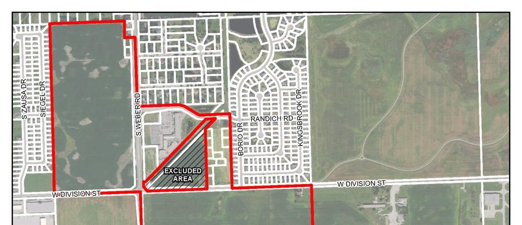
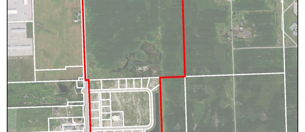
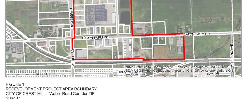
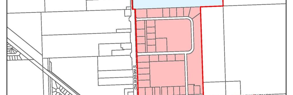
4 1. INTRODUCTION This document presents a Tax Increment Redevelopment Plan and Project (the "Plan") under the requirements of the Tax Increment Allocation Redevelopment Act (65 ILCS 5/ et seq.), as amended (the Act ) for the Weber Road Corridor TIF Redevelopment Project Area (the Project Area ) located in the City of Crest Hill, Illinois (the City ). The Project Area boundaries are delineated on Figure 1: Redevelopment Project Area Boundary in Appendix A and legally described in Appendix B. The Project Area is irregular in shape and includes improved properties east of Weber Road between Longmeadow Drive on the north and the Canadian National Railway line on the south as well as approximately 74 acres of vacant land at the northwest corner of Weber Road and Division Street. The Project Area also includes certain industrial properties south of Caton Farm Road between Weber Road and Oakland Avenue. The Project Area boundaries were drawn to generally include older, obsolete industrial properties with significant infrastructure improvement needs, vacant and underperforming retail centers, and land along Weber Road with significant development potential, assuming certain impediments to development can be overcome. A triangular-shaped area of land located north of Division Street is excluded from the Project Area because it is currently unincorporated, and is not being annexed into the City of Crest Hill at this time. This excluded area includes a natural gas utility pipeline right-of-way that extends through the northeast quadrant of the Project Area. The Project Area includes 74 tax parcels and is approximately 444 acres in size, including 31 acres of public rights-of-way. The 413 acres of net land area can accommodate a variety of development types. The current land use pattern includes a mix of residential, industrial and commercial uses, vacant lots platted to accommodate commercial uses and unimproved vacant land. There are 33 buildings in the Project Area, of which 8 or 24% are 35 years of age or older. This Plan responds to problem conditions within the Project Area as discussed herein and reflects a commitment by the City to improve and revitalize the Project Area. The purpose of this Plan is to encourage private redevelopment and reinvestment by making the public infrastructure investments and providing other assistance allowed under the Act to support private reinvestment, thereby stabilizing the tax base of the City and other taxing districts. The Plan summarizes the analyses and findings of the Consultant s work which, unless otherwise noted, is the responsibility of Camiros, Ltd. (the Consultant ). The City is entitled to rely on the findings and conclusions of this Plan in designating the Project Area as a redevelopment project area under the Act. The Consultant has prepared this Plan and the related eligibility study with the understanding that the City would rely: 1) on the findings and conclusions of the Plan and the related eligibility study in proceeding with the designation of the Project Area and the adoption and implementation of the Plan, and 2) on the fact that the Consultant has obtained the necessary information so that the Plan and the related eligibility study comply with the Act. The Plan presents certain conditions, research and analysis undertaken to document the eligibility of the Project Area for designation as a tax increment financing ( TIF ) district. The need for public intervention, goals and objectives, land use policies and other policy materials are presented in this Plan. The results of a study documenting the eligibility of the Project Area as a blighted area are presented in 1
5 Appendix C: Weber Road Corridor TIF Redevelopment Project Area Eligibility Study (the Eligibility Study ). Tax Increment Financing In adopting the Act, the Illinois State Legislature found at Section 5/ (a) that:... there exist in many municipalities within this State blighted, conservation and industrial park conservation areas, as defined herein; that the conservation areas are rapidly deteriorating and declining and may soon become blighted areas if their decline is not checked; and also found at Section 5/ (b) that: in order to promote and protect the health, safety, morals, and welfare of the public, that blighted conditions need to be eradicated and conservation measures instituted, and that redevelopment of such areas be undertaken; that to remove and alleviate adverse conditions it is necessary to encourage private investment and restore and enhance the tax base of the taxing districts in such areas by the development or redevelopment of project areas. The eradication of blighted areas and treatment and improvement of conservation areas and industrial park conservation areas by redevelopment projects is hereby declared to be essential to the public interest. In order to use the tax increment financing technique, a municipality must first establish that the proposed redevelopment project area meets the statutory criteria for designation as a blighted area, or a conservation area. A redevelopment plan must then be prepared that describes the development or redevelopment program intended to be undertaken to reduce or eliminate those conditions which qualified the redevelopment project area as a blighted area or conservation area or combination thereof, and thereby enhance the tax bases of the taxing districts which extend into the redevelopment project area. The statutory requirements are set out at 65 ILCS 5/ , et seq. The Act provides that, in order to be adopted, the Plan must meet the following conditions under 5/ (n): (1) the redevelopment project area on the whole has not been subject to growth and development through investment by private enterprise and would not be reasonably anticipated to be developed without the adoption of the redevelopment plan; (2) the redevelopment plan and project conform to the comprehensive plan for the development of the municipality as a whole, or, for municipalities with a population of 100,000 or more, regardless of when the redevelopment plan and project was adopted, the redevelopment plan and project either (i) conforms to the strategic economic development or redevelopment plan issued by the designated planning authority of the municipality, or (ii) includes land uses that have been approved by the planning commission of the municipality; 2
6 (3) the redevelopment plan establishes the estimated dates of completion of the redevelopment project and retirement of obligations issued to finance redevelopment project costs (which dates shall not be later than December 31 of the year in which the payment to the municipal treasurer as provided in Section 8 (b) of the Act is to be made with respect to ad valorem taxes levied in the twenty-third calendar year after the year in which the ordinance approving the redevelopment project area is adopted); (4) in the case of an industrial park conservation area, also that the municipality is a labor surplus municipality and that the implementation of the redevelopment plan will reduce unemployment, create new jobs and by the provision of new facilities enhance the tax base of the taxing districts that extend into the redevelopment project area; (5) if any incremental revenues are being utilized under Section 8 (a) (1) or 8 (a) (2) of this Act in redevelopment project areas approved by ordinance after January 1, 1986 the municipality finds (a) that the redevelopment project area would not reasonably be developed without the use of such incremental revenues, and (b) that such incremental revenues will be exclusively utilized for the development of the redevelopment project area; and (6) certification that a housing impact study need not be performed if less than 10 residential units will be displaced (see 5/ (n)(5) of the Act). Redevelopment projects are defined as any public or private development projects undertaken in furtherance of the objectives of the redevelopment plan in accordance with the Act. The Act provides a means for municipalities, after the approval of a redevelopment plan and project, to redevelop blighted, conservation, or industrial park conservation areas and to finance eligible redevelopment project costs with incremental property tax revenues. Incremental Property Tax or Incremental Property Taxes are derived from the increase in the current equalized assessed value ( EAV ) of real property within the redevelopment project area over and above the Certified Initial EAV of such real property. Any increase in EAV is then multiplied by the current tax rate to arrive at the Incremental Property Taxes. A decline in current EAV does not result in a negative Incremental Property Tax. To finance redevelopment project costs, a municipality may issue obligations secured by Incremental Property Taxes to be generated within the redevelopment project area. In addition, a municipality may pledge towards payment of such obligations any part or any combination of the following: (a) net revenues of all or part of any redevelopment project; (b) taxes levied and collected on any or all property in the municipality; (c) the full faith and credit of the municipality; (d) a mortgage on part or all of the redevelopment project; or (e) any other taxes or anticipated receipts that the municipality may lawfully pledge. Tax increment financing does not generate tax revenues. This financing mechanism allows the municipality to capture, for a certain number of years, the new tax revenues produced by the enhanced valuation of properties resulting from the municipality s redevelopment program, improvements and activities, various redevelopment projects, and the reassessment of properties. This revenue is then reinvested in the area through rehabilitation, developer subsidies, public improvements and other eligible redevelopment activities. Under tax increment financing, all taxing districts continue to receive 3
7 property taxes levied on the initial valuation of properties within the redevelopment project area. Additionally, taxing districts can receive distributions of excess Incremental Property Taxes when annual Incremental Property Taxes received exceed principal and interest obligations for that year and redevelopment project costs necessary to implement the redevelopment plan have been paid and such excess Incremental Property Taxes are not otherwise required, pledged or otherwise designated for other redevelopment projects. Taxing districts also benefit from the increased property tax base after redevelopment project costs and obligations are paid in full. The City authorized an evaluation to determine whether a portion of the City to be known as the Weber Road Corridor TIF Redevelopment Project Area (the Project Area ) qualifies for designation as a redevelopment project area under the provisions contained in the Act. If the Project Area so qualifies, the City also authorized the preparation of a redevelopment plan (the Plan ) for the Project Area in accordance with the requirements of the Act. As described in the Eligibility Study, attached as Appendix C, the Project Area is experiencing deterioration and lack of private investment. The analysis of conditions within the Project Area, which is based on an extensive examination of the records for and history of the properties included in the Project Area and several site visits and inspections, indicates that it is appropriate for designation as a blighted area under the Act. The Plan has been formulated in compliance with the provisions of the Act. This document is a guide to all proposed public and private actions in the Project Area. 4
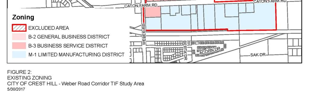
8 2. PROJECT AREA DESCRIPTION The Project Area includes only contiguous tax parcels that are anticipated to substantially benefit from the proposed redevelopment project area improvements. Community Context Crest Hill is located approximately 33 miles southwest of Chicago. Crest Hill s location and setting provides the framework for long-term growth. The older parts of the community generally developed in the late 1940s and early 1950s. Crest Hill was incorporated in In the decades since, Crest Hill has expanded to the north and west through annexations that have included the Stateville Correctional Center, portions of the Will County Forest Preserve and other areas poised for development. This new growth has primarily included residential subdivisions and industrial growth areas along the Weber Road Corridor. The Stateville Correctional Center property includes 1,264 acres of active facilities and open space. The westernmost 220 acres have been designated as excess by the State Department of Corrections and will be made available for development. The Project Area includes a 157-acre parcel with direct Weber Road access, constituting the major portion of this excess property. Sections of Weber Road to the north of the Project Area have seen tremendous commercial growth over the last 20 years but that growth has not extended south into the Project Area, even though Crest Hill s location within the region provides the necessary economic development framework and market potential. The Weber Road corridor represents Crest Hill s major opportunity for large-scale regional retail and commercial development, but because of blighting factors found within the Project Area has not been subject to private development. Large parcels and growing traffic counts should be the foundation for future growth, but the portion of the Weber Road Corridor included in the Project Area has been stagnant over a period of years. This threatens to adversely impact future development along Weber Road without public intervention. The Weber Road Corridor represents a unique opportunity for Crest Hill given the large amount of undeveloped land, anticipated growth in the high level of daily traffic volumes, and convenient access to nearby interstates. Although the northern and southern portions of the Weber Road corridor have been developed, the central portion of the corridor, which includes the Project Area, remains largely undeveloped. These large tracts of vacant and underutilized land represent an opportunity for economic development by accommodating large-scale contemporary development along Crest Hill s busiest street. Land Use and Zoning Crest Hill s most recent Comprehensive Plan was adopted in May The Comprehensive Plan serves as the City s official policy guide for physical improvements and long-term growth and development. The Comprehensive Plan strives to achieve a balanced approach that addresses continued growth along Weber Road and the revitalization of significant business centers and residential neighborhoods in the older portions of Crest Hill. The zoning classifications within the Project Area include B-2 General Business District, B-3 Business Service District and M-1 Limited Manufacturing District, as shown in Figure 2: Existing Zoning, found in Appendix A. 5
9 The Comprehensive Plan includes the Weber Road Subarea Plan, which provides specific land use and development recommendations for undeveloped and underutilized land that is currently within the City or could be annexed into Crest Hill in the future. It is anticipated that Weber Road will host regional commercial uses that provide services to residents, expand the City s tax base and establish an attractive character for the community. Between the Canadian National Railway and Division Street, the existing land use pattern includes smallscale industrial development located south of Caton Farm Road, the Weber Farm Crossings commercial subdivision, and a 157-acre parcel that is part of the Stateville Correctional Center holdings. This parcel is currently zoned for industrial use and contains one of two single-family houses located in the Project Area. The other house is located south of Caton Farm Road and is also within an industrial zoning district. The portions of the Project Area north of Division Street include the Blanchette Catholic Center and adjacent development parcels on the east side of Weber Road and 74 acres of vacant land on the west side of Weber Road. The development potential of the vacant land is constrained by the need to address runoff from this property onto adjacent properties within the existing watersheds. Future development will result in additional flooding without the provision of proper stormwater controls. Transportation Characteristics Weber Road serves as the primary access for property within the Project Area. Weber Road accommodates significant traffic volumes with between 19,600 and 24,000 Average Daily Traffic ( ADT ) and provides a direct interchange with I-55 approximately six miles north of the Project Area. The Weber Road Corridor is viewed as Crest Hill s future economic engine, accommodating a variety of retail, restaurant and other commercial uses. Caton Farm Road is currently configured as a rural cross section, serving local traffic. However, in the future it may see significant expansion as a result of the proposed Caton Farm Road expansion and bridge connection across the Des Plaines River and Chicago Sanitary and Shipping Canal. The proposed design under consideration by Will County includes a four-lane cross section with a center turn lane, Should this improvement come to fruition, the land use plan, zoning map and development regulations may need to be aligned to support the resulting development opportunities. 6
10 3. ELIGIBILITY OF THE PROJECT AREA FOR DESIGNATION AS A REDEVELOPMENT PROJECT AREA The Project Area on the whole has not been subject to growth and development through investment by private enterprise. Based on the conditions present, the Project Area is not likely to attract unassisted private sector investment without the creation of the Redevelopment Project Area and adoption of this Plan. Studies were undertaken to establish whether the proposed Project Area is eligible for designation as a blighted area or conservation area in accordance with the requirements of the Act. This analysis concluded that the Project Area qualifies for designation as a redevelopment project area because it is a blighted area as that term is defined in the Act. The presence of at least five of the 13 conditions stated in the Act is required for blighted area designation of improved properties. Two sets of eligibility factors apply to the designation of vacant land as a blighted area under the Act. These conditions must be meaningfully present and reasonably distributed within the Project Area. Improved property totals approximately 339 acres or 82% of the Project Area s 413 acres of net land area. The six conditions listed below were identified as being meaningfully present and reasonably distributed in the Project Area with respect to improved property: Obsolescence Deterioration Excessive vacancies Inadequate utilities Lack of community planning Lagging or declining equalized assessed valuation Vacant land represents approximately 74 acres, or 18% of the Project Area s net land area. This property qualifies for designation as a blighted vacant area under both sets of eligibility criteria. Where two factors are required, the following conditions are present: Obsolete platting Lagging or declining equalized assessed valuation (EAV) The vacant land is also adversely impacted by the following condition, which impairs sound growth of the Project Area: Chronic flooding pursuant to the definitions contained in the Act Besides establishing eligibility of the Project Area for designation as a blighted area, the presence of these conditions help to demonstrate the need for public intervention to attract private investment to the Project Area and achieve economic growth that will benefit all taxing districts through implementation of the Plan. For more details on the basis for eligibility, refer to Appendix C: Eligibility Study. 7
11 Need for Public Intervention The Project Area on the whole has not been subject to growth and investment by private enterprise and is not reasonably likely to attract new development without adoption of a Redevelopment Plan and Project. Although the Weber Road Corridor has been identified as a regional retail economic engine, a variety of impediments, which are described in the Eligibility Study, will need to be addressed to achieve this development vision. The tax base of the Project Area experienced an absolute decline in value between the 2011 and 2016 tax years. The highest value property within the Study Area is the Menard s store. The assessed value of this parcel was $4,713,710 for the 2011 tax year. By the 2016 tax year, the assessed value had dropped to $3,346,083, a 29% decline. Only ten improved tax parcels experienced positive appreciation between the 2011 and 2016 tax years. The adoption of this Plan will provide the City of Crest Hill with an important tool to help reverse this decline. The vacant land included in the Project Area was found to be subject to chronic flooding that adversely impacts on real property and the discharge of surface water that contributes to flooding within the same watershed. In order for this property to develop in accordance with Crest Hill s Comprehensive Plan, storm water management systems must be provided. The construction of detention and retention facilities in accordance with City, County and State requirements are beyond the capacity of private developers and will require public assistance. 8
12 4. REDEVELOPMENT PLAN GOALS AND OBJECTIVES This Plan is guided by a series of goals and objectives that describe how the Plan can help improve the Project Area. These goals and objectives are consistent with community vision, goals and objectives as set forth in the 2014 City of Crest Hill Comprehensive Plan for the Weber Road subarea. The delineation of these goals and objectives are also supported through research performed within the Project Area to document the presence of conditions that qualify the area for designation as a conservation area under the Act. General Goals The following general goals describe how the Plan can help improve the Project Area in furtherance of Crest Hill s Comprehensive Plan. 1. Create an attractive environment that encourages new commercial development and increases the tax base of the Project Area, thereby fostering confidence in new real estate investment. 2. Upgrade public utilities, infrastructure and streets as needed to attract and support new private investment, and alleviate flooding within the Project Area. 3. Reduce or eliminate those conditions that qualify the Project Area as a blighted area while maintaining the economic vitality of the Project Area. 4. Create an environment which will preserve or enhance the value of properties within and adjacent to the Project Area, improving the real estate and sales tax base for the City and other taxing districts that have jurisdiction over the Project Area. Redevelopment Objectives The following redevelopment objectives describe how the Plan can be used to help foster desired land uses and commercial activity within the Project Area. 1. Attract new businesses and retain existing businesses in order to maintain and increase the existing tax base. 2. Create employment opportunities including permanent full-time employment, temporary construction jobs, and job training as may be authorized under the Act. 3. Ensure that future development strengthens Crest Hill s role in the regional marketplace. 4. Encourage regional commercial development along Weber Road where lot sizes and a high level of access support larger development projects. 5. As new development occurs along Weber Road, continue to require internal street networks that eliminate turning conflicts along arterials and create the opportunity for distinct places that are welcoming to pedestrians and business patrons. Design Objectives Improving the appearance and appeal of the area is important to attracting new investment and strengthening the Project Area in general. The Plan includes the following design objectives that focus 9
13 on creating an attractive commercial environment in accordance with the Crest Hill Comprehensive Plan. 1. Reserve Weber Road frontage for prime commercial development that integrates attractive building design, high quality landscaping and uses that rely on direct visibility from the corridor. 2. Create appropriate buffers between land uses. 3. Require attractive landscaping and integrated green spaces that add to the character of the Weber Road corridor and mitigate stormwater runoff impacts. The preceding goals and objectives provide initial direction regarding priorities for making the public infrastructure improvements and investments to support private investment activity. It is anticipated that the Plan s goals and objectives will be reviewed throughout the life of the Plan and adjusted as required to successfully implement the Plan. 10
14 5. REDEVELOPMENT PLAN The City proposes to achieve the Plan s goals through the use of public financing techniques, including tax increment financing, and by undertaking some or all of the following actions: Property Assembly and Site Preparation To meet the goals and objectives of this Plan, the City may acquire and assemble property throughout the Project Area. Land assemblage by the City may be by purchase, exchange, donation, lease, or other available means of land acquisition. The purposes of land assemblage are to be able to (a) sell, lease or convey property to private developers committed to locating in the Project Area, or to (b) sell, lease, or convey or dedicate the land for the construction of public improvements or facilities. The City may enter into written redevelopment agreements with developers before acquiring or conveying land to ensure that properties are developed in accordance with the goals of this Plan, the City s design objectives and land use goals. As appropriate, the City may devote acquired property to temporary uses until such property is scheduled for disposition and development. If the City elects to exercise its power to acquire real property in implementing the Plan under the Act, the City will follow its customary procedures. Acquisition of such real property as may be authorized by the City Council does not constitute a change in the nature of this Plan. Intergovernmental and Redevelopment Agreements The City may enter into redevelopment agreements or intergovernmental agreements with private entities or other public entities to construct, rehabilitate, renovate or restore private or public improvements on one or several parcels (collectively referred to as Redevelopment Projects ). Terms of redevelopment as part of a redevelopment project may be incorporated in appropriate redevelopment agreements. For example, the City may agree to reimburse a developer for incurring certain eligible redevelopment project costs under the Act. Such agreements may contain specific development controls as allowed by the Act. Analysis, Professional Services and Administrative Activities The City may undertake or engage professional consultants, engineers, architects, attorneys, and others to conduct various analyses, studies, administrative legal services or other professional services to establish, implement and manage the Plan. Provision of Public Improvements and Facilities Adequate public improvements and facilities are required to support future development in the Project Area. Public improvements and facilities may include, but are not limited to construction and extension of new stormwater detention facilities, new and rehabilitation of stormwater conveyance facilities, sanitary sewer facilities, domestic water service, public streets, street closures to facilitate assembly of development sites, upgrading streets, signalization improvements, provision of 11
15 streetscape amenities, parking improvements, utility improvements, property access improvements, roadway lighting, sidewalk construction and rehabilitation, and other multi-model transportation improvements. Financing Costs Pursuant to the Act Interest on any obligations issued under the Act accruing during the estimated period of construction of the redevelopment project and other financing costs may be paid from the incremental tax revenues pursuant to the provisions of the Act. Interest Costs Pursuant to the Act Pursuant to the Act, the City may allocate a portion of the incremental tax revenues to pay or reimburse developers for interest costs incurred in connection with redevelopment activities in order to enhance the redevelopment potential of the Project Area. 12
16 6. REDEVELOPMENT PROJECT DESCRIPTION This Plan seeks to encourage new private development by facilitating a range of redevelopment and conservation actions. Reducing the prevalence of blighting conditions, such as deterioration, inadequate utilities, obsolescence, excessive vacancy, and chronic flooding is essential to stabilizing and conserving the Project Area. The Plan recognizes that new private investment is needed to improve and revitalize the Project Area. Public investments in infrastructure and community facilities may also be needed. The redevelopment of the Project Area is expected to encourage economic revitalization within the Project Area and the surrounding area. Commercial Rehabilitation and Redevelopment The City may need to provide certain eligible assistance to stimulate private investment in the Project Area. The improved portion of the Project Area includes obsolete commercial and industrial properties that adversely impact the development potential of other portions of the Project Area that contain project-ready development sites. Rehabilitation and/or redevelopment of these properties may need to be undertaken to induce new private investment. Public Infrastructure and Stormwater Management Improvements The City may need to provide assistance to support improvements to public infrastructure and facilities to alleviate the current flooding in the Project Area and address other required public infrastructure needs. As described in the Eligibility Study, significant stormwater management improvements will be required to alleviate the chronic flooding from the vacant land in the Project Area. Without proper stormwater controls, such as detention, storm sewers and grading, there could be detrimental effects, increased stormwater elevations and/or adverse impacts to downstream properties. Because the Project Area includes several large parcels that will need to be subdivided and reconfigured to support the anticipated future land use mix, new streets and utility extensions are also required elements of the Redevelopment Project. Property Acquisition and Disposition In order to facilitate redevelopment project activities, the acquisition of property may be required. 13
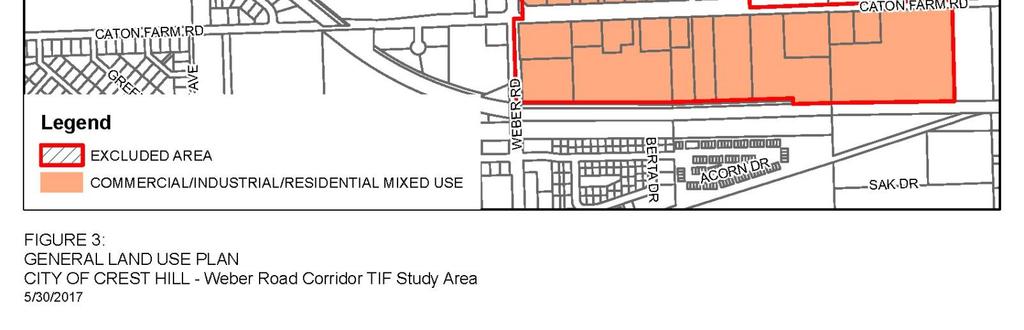
17 7. GENERAL LAND USE PLAN AND MAP Figure 3: General Land Use Plan, in Appendix A, identifies land uses expected to result from implementation of the Plan. The land use designation is commercial/industrial/residential mixed-use. While most of the Project Area is expected to be devoted to regional commercial development, there may also be opportunities in certain areas to incorporate residential uses with appropriate buffers from Weber Road traffic and the Stateville Correctional Center. Large scale industrial uses may also be viable in certain locations along with revitalization of the current light industrial district on the south side of Caton Farm Road. The mixed-use designation provides guidance and flexibility in future land use policy decisions where a variety of commercial and business uses may be appropriate and responsive to market demand. The land use plan is intended to direct development toward the most appropriate land use pattern for the Project Area and enhance the overall development of the Project Area in accordance with the goals and objectives of this Plan and the Crest hill Comprehensive Plan. Locations of specific uses, or public infrastructure improvements, may vary from the General Land Use Plan as a result of more detailed planning and site design activities. Such variations are permitted without amendment to the Plan as long as they are consistent with the Plan s goals and objectives and the land uses and zoning approved by the Crest Hill Plan Commission and City Council. 14
18 8. REDEVELOPMENT PLAN FINANCING Tax increment financing is an economic development tool designed to facilitate the redevelopment of blighted areas and to arrest decline in conservation areas that may become blighted without public intervention. It is expected that tax increment financing will be an important means, although not necessarily the only means, of financing improvements and providing development incentives in the Project Area throughout its 23-year life. Tax increment financing can only be used when private investment would not reasonably be expected to occur without public assistance. The Act sets forth the range of public assistance that may be provided. It is anticipated that expenditures for redevelopment project costs will be carefully staged in a reasonable and proportional basis to coincide with expenditures for redevelopment by private developers and the projected availability of tax increment revenues. The various redevelopment expenditures that are eligible for payment or reimbursement under the Act are reviewed below. Following this review is a list of estimated redevelopment project costs that are deemed to be necessary to implement this Plan (the Redevelopment Project Costs or Project Budget ). In the event the Act is amended after the date of the approval of this Plan by the Crest Hill City Council to a) include new eligible redevelopment project costs, or b) expand the scope or increase the amount of existing eligible redevelopment project costs (such as, for example, by increasing the amount of incurred interest costs that may be paid under 65 ILCS 5/ (q)(11)), this Plan shall be deemed to incorporate such additional, expanded or increased eligible costs as Redevelopment Project Costs under the Plan, to the extent permitted by the Act. In the event of such amendment(s) to the Act, the City may add any new eligible redevelopment project costs as a line item in Table 1: Estimated Redevelopment Project Costs or otherwise adjust the line items in Table 1 without amendment to this Plan, to the extent permitted by the Act. In no instance, however, shall such additions or adjustments result in any increase in the total Redevelopment Project Costs without a further amendment to this Plan, in accordance with the provisions of the Act. Eligible Redevelopment Costs Redevelopment project costs include the sum total of all reasonable or necessary costs incurred, estimated to be incurred, or incidental to this Plan pursuant to the Act. Such costs may include, without limitation, the following: a) Costs of studies, surveys, development of plans and specifications, implementation and administration of the Plan including but not limited to, staff and professional service costs for architectural, engineering, legal, financial, planning or other services (excluding lobbying expenses), provided that no charges for professional services are based on a percentage of the tax increment collected; b) The costs of marketing sites within the Project Area to prospective businesses, developers and investors; 15
19 c) Property assembly costs, including but not limited to, acquisition of land and other property, real or personal, or rights or interests therein, demolition of buildings, site preparation, site improvements that serve as an engineered barrier addressing ground level or below ground environmental contamination, including, but not limited to parking lots and other concrete or asphalt barriers, and the clearing and grading of land; d) Costs of rehabilitation, reconstruction or repair or remodeling of existing public or private buildings, fixtures, and leasehold improvements; and the costs of replacing an existing public building if pursuant to the implementation of a redevelopment project the existing public building is to be demolished to use the site for private investment or devoted to a different use requiring private investment; including any direct or indirect costs relating to Green Globes or LEED certified construction elements or construction elements with an equivalent certification; e) Costs of the construction of public works or improvements, including any direct or indirect costs relating to Green Globes or LEED certified construction elements or construction elements with an equivalent certification subject to the limitations in Section (q)(4) of the Act; f) Costs of job training and retraining projects including the cost of welfare to work programs implemented by businesses located within the Project Area; g) Financing costs including, but not limited to, all necessary and incidental expenses related to the issuance of obligations and which may include payment of interest on any obligations issued thereunder including interest accruing during the estimated period of construction of any redevelopment project for which such obligations are issued and for a period not exceeding 36 months following completion and including reasonable reserves related thereto; h) To the extent the City by written agreement accepts and approves the same, all or a portion of a taxing district s capital costs resulting from the redevelopment project necessarily incurred or to be incurred within a taxing district in furtherance of the objectives of the Plan. i) An elementary, secondary or unit school district, or public library district s increased costs attributable to assisted housing units will be reimbursed as provided in the Act; j) Relocation costs to the extent that the City determines that relocation costs shall be paid or is required to make payment of relocation costs by federal or state law or by Section (n)(7) of the Act; k) Payment in lieu of taxes, as defined in the Act; l) Costs of job training, retraining, advanced vocational education or career education, including but not limited to, courses in occupational, semi-technical or technical fields leading directly to employment, incurred by one or more taxing districts, provided that such costs; (i) are related to the establishment and maintenance of additional job training, advanced vocational education or career education programs for persons employed or to be employed by employers located in the Project Area; and (ii) when incurred by a taxing district or taxing districts other than the City, are set forth in a written agreement by or among the City and the 16
20 taxing district or taxing districts, which agreement describes the program to be undertaken including but not limited to, the number of employees to be trained, a description of the training and services to be provided, the number and type of positions available or to be available, itemized costs of the program and sources of funds to pay for the same, and the term of the agreement. Such costs include, specifically, the payment by community college districts of costs pursuant to Sections 3-37, 3-38, 3-40, and of the Public Community College Act, 110 ILCS 805/3-37, 805/3-38, 805/3-40 and 805/3-40.1, and by school districts of costs pursuant to Sections a and a of the School Code, 105 ILCS 5/ a and 5/ a; m) Interest costs incurred by a redeveloper related to the construction, renovation or rehabilitation of a redevelopment project provided that: 1) such costs are to be paid directly from the special tax allocation fund established pursuant to the Act; 2) such payments in any one year may not exceed 30 percent of the annual interest costs incurred by the redeveloper with regard to the redevelopment project during that year; 3) if there are not sufficient funds available in the special tax allocation fund to make the payment pursuant to this provision, then the amounts so due shall accrue and be payable when sufficient funds are available in the special tax allocation fund; 4) the total of such interest payments paid pursuant to the Act may not exceed 30 percent of the total: (i) cost paid or incurred by the redeveloper for such redevelopment project; (ii) redevelopment project costs excluding any property assembly costs and any relocation costs incurred by the City pursuant to the Act; and 5) up to 75 percent of the interest cost incurred by a redeveloper for the financing of rehabilitated or new housing for low-income households and very low-income households, as defined in Section 3 of the Illinois Affordable Housing Act. n) Instead of the eligible costs provided for in (m) 2, 4 and 5 above, the City may pay up to 50 percent of the cost of construction, renovation and/or rehabilitation of all low- and very lowincome housing units (for ownership or rental) as defined in Section 3 of the Illinois Affordable Housing Act. If the units are part of a residential redevelopment project that includes units not affordable to low- and very low-income households, only the low- and very low-income units shall be eligible for benefits under the Act; o) The costs of daycare services for children of employees from low-income families working for businesses located within the Project Area and all or a portion of the cost of operation of day care centers established by Project Area businesses to serve employees from low-income families working in businesses located in the Project Area if the Project Area is located within a municipality with a population of more than 100,000. For the purposes of this paragraph, low-income families means families whose annual income does not exceed 80 percent of the City, county or regional median income as determined from time to time by the United States Department of Housing and Urban Development. 17
21 p) Unless explicitly provided in the Act, the cost of construction of new privately-owned buildings shall not be an eligible redevelopment project cost; q) The Act contains limitations on eligible project costs related to a retail entity initiating operations in the redevelopment project area while terminating operations at another Illinois location within ten miles of the redevelopment project area, but outside of the boundaries of the redevelopment project area municipality. r) No cost shall be an eligible project cost if used to demolish, remove, or substantially modify a historic resource, unless no prudent and feasible alternative exists. This provision does not apply to a place or structure for which demolition, removal or modification is subject to review by the preservation agency of a designated Certified Local Government. s) If a special service area has been established pursuant to the Special Service Area Tax Act, 35 ILCS 235/0.01 et seq., then any tax increment revenues derived from the tax imposed pursuant to the Special Service Area Tax Act may be used within the Project Area for the purposes permitted by the Special Service Area Tax Act as well as the purposes permitted by the Act. Redevelopment Project Cost Budget Not every eligible project cost listed in the Act is contemplated to achieve the goals and objectives of the Plan. The eligible project cost line items that constitute the project budget of the Plan are listed in Figure 1: Estimated Redevelopment Project Costs. Costs may be reallocated among line items, as long as the total costs do not exceed the total set forth in this Plan or are expressly authorized under the Act. The maximum estimated gross eligible project cost over the life of the Project Area is $180 million. All project cost estimates are in 2017 dollars. Any bonds issued to finance portions of the redevelopment project may include an amount of proceeds sufficient to pay customary and reasonable charges associated with issuance of such obligations, as well as to provide for capitalized interest and reasonably required reserves. The total project cost figure excludes any costs for the issuance of bonds. Adjustments to estimated line items, which are upper estimates for these costs, are expected and may be made without amendment to the Plan. Additional funding from other sources such as federal, state, county, or local grant funds may be utilized to supplement the City s ability to finance Redevelopment Project Costs identified above. In the event there are costs savings in certain line items, the City reserves the right to re-allocate dollars among the line items listed below. The total reflects the maximum amount the City could spend over the 23 year life of the TIF; it does not reflect any expenditures or commitments the City has made. 18
22 Table 1: Estimated Redevelopment Project Costs Eligible Expense Estimated Cost Analysis, Planning, Engineering, Surveys, Legal, etc. $6,000,000 Marketing Costs $1,000,000 Property Assembly including Acquisition, Demolition, Site Preparation $15,000,000 Relocation and Environmental Remediation Rehabilitation of Existing Buildings, Fixtures and Leasehold $2,000,000 Improvements Public Works and Improvements $150,000,000 Financing Costs and Required Payments (pursuant to the provisions of $3,000,000 the Act) Interest Costs $3,000,000 TOTAL REDEVELOPMENT PROJECT COSTS $180,000,000 Sources of Funds Funds necessary to pay for Redevelopment Project Costs and secure municipal obligations issued for such costs are to be derived primarily from Incremental Property Taxes. Other sources of funds which may be used to pay for Redevelopment Project Costs or secure municipal obligations are land disposition proceeds, state and federal grants, investment income, private financing and other legally permissible funds the City may deem appropriate. The City may incur redevelopment project costs which are paid for from funds of the City other than incremental taxes, and the City may then be reimbursed from such costs from incremental taxes. Also, the City may permit the utilization of guarantees, deposits and other forms of security made available by private sector developers. Additionally, the City may utilize revenues, other than State sales tax increment revenues, received under the Act from one redevelopment project area for eligible costs in another redevelopment project area that is either contiguous to, or is separated only by a public right-of-way from, the redevelopment project area from which the revenues are received. The Project Area may be contiguous to or separated by only a public right-of-way from other redevelopment project areas created under the Act. The City may utilize net incremental property taxes received from the Project Area to pay eligible redevelopment project costs, or obligations issued to pay such costs, in other contiguous redevelopment project areas or project areas separated only by a public right-of-way, and vice versa pursuant to the provisions of the Act. The Project Area may become contiguous to, or be separated only by a public right-of-way from, redevelopment project areas created under the Industrial Jobs Recovery Law (65 ILCS 5/ et seq.). If the City finds that the goals, objectives and financial success of such contiguous redevelopment project areas, or those separated only by a public right-of-way, are interdependent with those of the Project Area, the City may determine that it is in the best interests of the City, and in furtherance of the purposes of the Plan, that net revenues from the Project Area be made available to support any such redevelopment project areas and vice versa. The City therefore proposes to utilize net incremental 19
23 revenues received from the Project Area to pay eligible redevelopment project costs (which are eligible under the Industrial Jobs Recovery Law referred to above) in any such areas, and vice versa. Such revenues may be transferred or loaned between the Project Area and such areas. The amount of revenue from the Project Area made available, when added to all amounts used to pay eligible Redevelopment Project Costs within the Project Area, or other areas described in the preceding paragraph, shall not at any time exceed the total Redevelopment Project Costs described in Table 1: Estimated Redevelopment Project Costs. Issuance of Obligations The City may issue obligations secured by Incremental Property Taxes pursuant to Section of the Act. To enhance the security of a municipal obligation, the City may elect to pledge its full faith and credit through the issuance of general obligations bonds, but is not required to do so and at the current time has no plans to do so. Additionally, the City may provide other legally permissible credit enhancements to any obligations issued pursuant to the Act. The redevelopment project shall be completed, and all obligations issued to finance redevelopment costs shall be retired, no later than December 31st of the year in which the payment to the City treasurer as provided in the Act is to be made with respect to ad valorem taxes levied in the twentythird calendar year following the year in which the ordinance approving the Project Area is adopted. Also, although the life of the Project Area is 23 years, the final maturity date of any such obligations which are issued may not be later than 20 years from their respective dates of issue. One or more series of obligations may be sold at one or more times in order to implement this Plan. Obligations may be issued on a parity or subordinated basis. In addition to paying Redevelopment Project Costs, Incremental Property Taxes may be used for the scheduled retirement of obligations, mandatory or optional redemptions, establishment of debt service reserves and bond sinking funds. To the extent that Incremental Property Taxes are not needed for these purposes, and are not otherwise required, pledged, earmarked or otherwise designated for the payment of Redevelopment Project Costs, any excess Incremental Property Taxes shall then become surplus as that term is defined in the Act and shall be distributed annually on a pro rata basis to taxing districts having the authority fo levy property taxes in the Project Area as provided by the Act. NOTHING HEREIN SHALL BE CONSTRUED AS A COMMITMENT OF THE CITY TO USE ITS FULL FAITH AND CREDIT TO SUPPORT ANY TIF OBLIGATIONS ISSUED OR ANY AGREEMENTS ENTERED INTO WITHOUT THE EXPRESS APPROVAL OF THE CITY COUNCIL GIVEN IN COMPLIANCE WITH ILLINOIS LAW. Most Recent Equalized Assessed Valuation (EAV) The purpose of identifying the most recent equalized assessed valuation ( EAV ) of the Project Area is to provide an estimate of the initial EAV which the Will County Clerk will certify for the purpose of annually calculating the incremental EAV and incremental property taxes of the Project Area. The 2016 EAV of all taxable parcels in the Project Area is approximately $6,821,980. This total EAV amount, listed by parcel, is summarized in Appendix D. The EAV is subject to verification by the Will County Clerk. After verification, the final figure shall be certified by the Will County Clerk, and shall become the Certified Initial EAV from which all incremental property taxes in the Project Area will be calculated by Will 20
24 County. The Plan has utilized the EAVs for the 2016 tax year. If the 2017 EAV shall become available prior to the date of the adoption of the Plan by the City Council, the City may update the Plan by replacing the 2016 EAV with the 2017 EAV. Anticipated Equalized Assessed Valuation Once the redevelopment project has been completed and the property is fully assessed, the estimated EAV of real property within the Project Area is expected to be in the range of $130 to $170 million. This estimate has been calculated assuming that the Project Area will be developed in accordance with Figure 3: General Land Use Plan presented in Appendix A. The estimated EAV assumes that the assessed value of property within the Project Area will increase substantially as a result of new development and public improvements. Calculation of the estimated EAV is based on the following assumptions: 1) the redevelopment of the Project Area will occur in a timely manner, and 2) an average annual appreciation rate of 3.5% is assumed throughout the life of the TIF. Financial Impact on Taxing Districts The Act requires an assessment of any financial impact of the Project Area on, or any increased demand for services from, any taxing district affected by the Plan and a description of any program to address such financial impacts or increased demand. The City intends to monitor development in the Project Area and with the cooperation of the other affected taxing districts will attempt to ensure that any increased needs are addressed in connection with any particular development. The following taxing districts presently levy taxes on properties located within the Project Area: Will County. The County has principal responsibility for the protection of persons and property, the provision of public health services and the maintenance of County highways. Forest Preserve District of Will County. The Forest Preserve District is responsible for acquisition, restoration and management of lands for the purpose of protecting and preserving open space in the City and County for the education, pleasure and recreation of the public. Lockport Township. Lockport Township is a basic division of a County with powers to levy taxes, pass local ordinances and regulations, and provide various services as authorized by state statutes and elected officials. Lockport Township Road Fund. This levy covers administrative costs, department employee salaries and costs to construct, maintain and repair township roads and bridges, and is the responsibility of the Township Highway Commissioner. City of Crest Hill. The City is a non-home rule municipality that is responsible for the provision of a wide range of municipal services, including police, capital improvements and maintenance, water supply and distribution, sanitation service and building, housing and zoning codes, and the maintenance of City streets funded through the Crest Hill Road and Bridge levy. White Oak Library District. The District serves the greater Crest Hill, Lockport and Romeoville communities. The Library s mission is to facilitate the sharing of knowledge among people of all ages by providing various format in an organized, accessible collection for the purpose of enriching lives 21
25 through accurate information, reading and entertainment within an inviting facility. The new Crest Hill Branch Library opened to the public in Richland Grade School District 88A. District 88A is a two-school district, with Richland Elementary School and Richland Junior High School operating on a consolidated campus. General responsibilities of School District 88A include the provision, maintenance and operations of educational facilities and the provision of educational services for kindergarten through eighth grade. The district serves the western portion of Crest Hill and adjacent areas. Enrollment is approximately 900 students. The current facilities have a capacity of approximately 1,200 students. Chaney-Monge School District 88. This single school district was established in 1916 and serves approximately 475 students living in the eastern portion of Crest Hill. Lockport Township High School District 205. Lockport Township High School is one of the largest school districts in Illinois, with about 3,700 students. The District covers approximately 65 square miles and serves Crest Hill, Fairmont, Homer Glen, Lockport, Homer Township and Lockport Township. Joliet Junior District College District 525. The Junior College District is a unit of the State of Illinois' system of public community colleges, whose objective is to meet the educational needs of residents of the City and other students seeking higher education programs and services. Joliet Junior College enjoys the distinction of being the nation s first public community college, today serving approximately 210,000 households and 700,000 residents. Lockport Township Park District. Created in 1945, the Park District is responsible for the provision, maintenance and operation of park and recreational facilities and for the provision of recreation programs throughout Lockport Township and portions of the City of Lockport that are located in Homer Township. Lockport Fire District. The Fire District was established in 1956 and serves Lockport, Crest Hill, parts of Romeoville and new Lenox, and portions of DuPage, Homer, Joliet, Plainfield, Troy and New Lenox Townships. The proposed revitalization of the Project Area may create an increase in demand on public services and facilities as properties within the Project Area are redeveloped. However, the public service demand is not anticipated to be significant since the new buildings will be built in accordance with current building and life safety codes and meet Will County stormwater management requirements. Although the specific nature and timing of the private investment expected to be attracted to the Project Area cannot be precisely quantified at this time, a general assessment of financial impact can be made based upon the level of development and timing anticipated by the proposed Plan. While the land use plan anticipates that most of the Project Area will be developed with commercial and industrial uses, future residential development may occur limited portions of the Project Area. The Act includes formulas to reimburse elementary and secondary school districts and public library districts for any increased service costs associated with new residential populations. It is expected that most of the increases in demand for the services and programs of the aforementioned taxing districts, associated with commercial and industrial development within the Project Area, can be adequately addressed by the existing services and programs maintained by these taxing districts. A portion of the Project Budget has been allocated for public works and improvements, which may be used to address potential public service demands associated with implementing the Plan. 22
26 Upon completion of the Plan, all taxing districts are expected to share the benefits of a substantially improved tax base. When completed, developments in the Project Area will generate property tax revenues for all taxing districts. Other revenues may also accrue to the City in the form of sales tax, business fees and licenses, and utility user fees. Real estate tax revenues resulting from increases in the EAV, over and above the Certified Initial EAV established with the adoption of the Plan, will be used to pay eligible redevelopment costs in the Project Area. Following termination of the Project Area, the real estate tax revenues, attributable to the increase in the EAV over the certified initial EAV, will be distributed to all taxing districts levying taxes against property located in the Project Area. Successful implementation of the Plan is expected to result in new development and private investment on a scale sufficient to overcome blighted conditions and substantially improve the long-term economic value of the Project Area. Completion of the Redevelopment Project and Retirement of Obligations to Finance Redevelopment Project Costs The Plan will be completed, and all obligations issued to finance redevelopment costs shall be retired, no later than December 31st of the year in which the payment to the City treasurer as provided in the Act is to be made with respect to ad valorem taxes levied in the twenty-third calendar year following the year in which the ordinance approving the Plan is adopted (assuming adoption in 2017, by December 31, 2041). 23
27 9. HOUSING IMPACT STUDY APPLICABILITY As set forth in the Act, if the redevelopment plan for a redevelopment project area would result in the displacement of residents from 10 or more inhabited residential units, or if the redevelopment project area contains 75 or more inhabited residential units and a municipality is unable to certify that no displacement will occur, the municipality must prepare a housing impact study and incorporated the study in the redevelopment project plan. The Project Area contains two single-family residential units. These residential uses are located on property currently zoned for industrial use and over time are expected to be replaced by more appropriate land uses. However, even with future displacement, the threshold for completing a housing impact study is not met. Thus, a housing impact study is not a required element of this Plan. 24
28 10. PROVISIONS FOR AMENDING THE PLAN The Plan may be amended in accordance with the provisions of the Act. 25
29 11. CITY OF CREST HILL COMMITMENT TO FAIR EMPLOYMENT PRACTICES AND AFFIRMATIVE ACTION The City is committed to and will affirmatively implement the following principles with respect to this Plan: A) The assurance of equal opportunity in all personnel and employment actions, with respect to the Redevelopment Project, including, but not limited to hiring, training, transfer, promotion, discipline, fringe benefits, salary, employment working conditions, termination, etc., without regard to race, color, sex, age, religion, disability, national origin, ancestry, sexual orientation, marital status, parental status, military discharge status, source of income, or housing status. B) This commitment to affirmative action and nondiscrimination will ensure that all members of the protected groups are sought out to compete for all job openings and promotional opportunities. C) Redevelopers will meet City standards for any applicable prevailing wage rate as ascertained by the Illinois Department of Labor to all project employees. The City shall have the right in its sole discretion to exempt certain small businesses, residential property owners and developers from the above. 26
30 APPENDIX A WEBER ROAD CORRIDOR TIF REDEVELOPMENT PROJECT AREA FIGURES 1-3 A-1
31 A-2


32 A-3
33 A-4
34 APPENDIX B WEBER ROAD CORRIDOR TIF REDEVELOPMENT PROJECT AREA LEGAL DESCRIPTION 1. ALL THAT PART OF THE SOUTHEAST QUARTER OF SECTION 19, THE SOUTHWEST QUARTER OF SECTION 20, THE WEST HALF OF SECTION 29 AND THE NORTH HALF OF SECTION 32, ALL IN TOWNSHIP 36 NORTH, RANGE 10 EAST OF THE THIRD PRINCIPAL MERIDIAN, BOUNDED AND DESCRIBED AS FOLLOWS: 2. BEGINNING AT THE POINT OF INTERSECTION OF THE CENTERLINE WEBER ROAD WITH THE CENTERLINE OF STATEVILLE ROAD (DIVISION STREET), BEING ALSO THE SOUTHEAST CORNER OF SECTION 19 AFORESAID; 3. THENCE WEST ALONG THE CENTERLINE OF STATEVILLE ROAD, BEING ALSO THE SOUTH LINE OF SECTION 19 AFORESAID, TO THE WEST LINE OF THE EAST HALF OF THE SOUTHEAST QUARTER OF SAID SECTION 19; 4. THENCE NORTH ALONG SAID WEST LINE OF THE EAST HALF OF THE SOUTHEAST QUARTER OF SECTION 19 AFORESAID TO THE NORTH LINE OF SAID SOUTHEAST QUARTER OF SECTION 19; 5. THENCE EAST ALONG SAID NORTH LINE OF THE SOUTHEAST QUARTER OF SECTION 19 TO THE WEST LINE OF THE EAST 10 RODS THEREOF; 6. THENCE SOUTH ALONG SAID WEST LINE OF THE EAST 10 RODS OF THE SOUTHEAST QUARTER OF SECTION 19 TO THE NORTH LINE OF LOT 1 IN WEBER TERRACE SUBDIVISION OF A PART OF THE SOUTHEAST QUARTER OF SECTION 19 AFORESAID; 7. THENCE EAST ALONG SAID NORTH LINE OF LOT 1 IN WEBER TERRACE SUBDIVISION AND ITS EASTERLY EXTENSION TO THE CENTERLINE OF WEBER ROAD, BEING ALSO THE WEST LINE OF THE SOUTHWEST QUARTER OF SECTION 20 AFORESAID; 8. THENCE SOUTH ALONG SAID CENTERLINE OF WEBER ROAD TO THE NORTH LINE OF THE SOUTHWEST QUARTER OF THE SOUTHWEST QUARTER OF SECTION 20 AFORESAID; 9. THENCE EAST ALONG SAID NORTH LINE OF THE SOUTHWEST QUARTER OF THE SOUTHWEST QUARTER OF SECTION 20 TO THE WEST LINE OF LOT 8 IN CROSSROADS CREST HILL EAST, BEING A SUBDIVISION OF PART OF THE SOUTHWEST QUARTER OF SECTION 20 AFORESAID; 10. THENCE SOUTH ALONG SAID WEST LINE OF LOT 8 IN CROSSROADS CREST HILL EAST TO THE SOUTHERLY LINE THEREOF, BEING ALSO THE NORTHERLY LINE OF LONGMEADOW DRIVE; B-1
35 11. THENCE EAST ALONG SAID NORTHERLY LINE OF LONGMEADOW DRIVE TO THE EAST LINE OF THE WEST HALF OF THE SOUTHWEST QUARTER OF SECTION 20 AFORESAID; 12. THENCE SOUTH ALONG SAID EAST LINE OF THE WEST HALF OF THE SOUTHWEST QUARTER OF SECTION 20 TO THE CENTERLINE OF STATEVILLE ROAD, BEING ALSO THE NORTH LINE OF THE NORTHWEST QUARTER OF SECTION 29 AFORESAID; 13. THENCE EAST ALONG CENTERLINE OF STATEVILLE ROAD, AND SAID NORTH LINE OF THE NORTHWEST QUARTER OF SECTION 29, TO THE NORTHWEST CORNER OF THE NORTHWEST QUARTER OF SECTION 29 AFORESAID; 14. THENCE SOUTH ALONG THE EAST LINE OF SAID NORTHWEST QUARTER OF SECTION 29 TO THE SOUTHEAST CORNER THEREOF; 15. THENCE WEST ALONG THE SOUTH LINE OF SAID NORTHWEST QUARTER OF SECTION 29 TO THE EAST LINE OF LOTS 20 AND 21 IN WEBER FARM CROSSINGS OF CREST HILL, BEING A SUBDIVISION OF PART OF THE SOUTHWEST QUARTER OF SECTION 29 AFORESAID; 16. THENCE SOUTH ALONG SAID EAST LINE OF LOTS 20 AND 21 IN WEBER FARM CROSSINGS OF CREST HILL AND THE SOUTHERLY EXTENSION THEREOF TO THE CENTERLINE OF CATON FARM ROAD, BEING ALSO THE NORTH LINE OF SECTION 32 AFORESAID; 17. THENCE EAST ALONG SAID CENTERLINE OF CATON FARM ROAD, AND SAID NORTH LINE OF SECTION 32, TO THE NORTHERLY EXTENSION OF THE WEST LINE OF THE EAST 320 FEET OF LOT 1 IN MONARCH INDUSTRIAL SUBDIVISION, A RESUBDIVISION OF PART OF THE NORTHEAST QUARTER OF SECTION 32 AFORESAID; 18. THENCE SOUTH ALONG SAID NORTHERLY EXTENSION AND THE WEST LINE OF THE EAST 320 FEET OF LOT 1 IN MONARCH INDUSTRIAL SUBDIVISION TO THE NORTH LINE OF THE ELGIN, JOLIET & EASTERN RAILWAY; 19. THENCE WEST ALONG SAID NORTH LINE OF THE ELGIN, JOLIET & EASTERN RAILWAY TO THE WEST LINE OF THE EAST HALF OF THE EAST HALF OF THE NORTHWEST QUARTER OF SECTION 32 AFORESAID; 20. THENCE NORTH ALONG SAID WEST LINE OF THE EAST HALF OF THE EAST HALF OF THE NORTHWEST QUARTER OF SECTION 32 TO A LINE 50 FEET NORTH OF AND PARALLEL WITH THE NORTH LINE OF THE ELGIN, JOLIET & EASTERN RAILWAY; 21. THENCE WEST ALONG SAID LINE 50 FEET NORTH OF AND PARALLEL WITH THE NORTH LINE OF THE ELGIN, JOLIET & EASTERN RAILWAY TO THE CENTERLINE OF WEBER ROAD, BEING ALSO THE WEST LINE OF THE NORTHWEST QUARTER OF SECTION 32 AFORESAID; 22. THENCE NORTH ALONG SAID CENTERLINE OF WEBER ROAD TO THE CENTERLINE OF CATON FARM ROAD, BEING ALSO THE SOUTHWEST CORNER OF SECTION 29 AFORESAID; B-2
36 23. THENCE EAST ALONG SAID CENTERLINE OF CATON FARM ROAD TO THE SOUTHERLY EXTENSION OF THE WEST LINE OF WEBER FARM CROSSING OF CREST HILL IN THE SOUTHWEST QUARTER OF SECTION 29 AFORESAID; 24. THENCE NORTH ALONG SAID SOUTHERLY EXTENSION AND EAST THE WEST LINE OF WEBER FARM CROSSING OF CREST HILL TO THE SOUTH LINE OF THE NORTHWEST QUARTER OF SECTION 29 AFORESAID; 25. THENCE WEST ALONG SAID SOUTH LINE OF THE NORTHWEST QUARTER OF SECTION 29 TO THE WEST LINE THEREOF, BEING ALSO THE CENTERLINE OF WEBER ROAD; 26. THENCE NORTH ALONG SAID CENTERLINE WEBER ROAD TO ITS INTERSECTION WITH THE CENTERLINE OF STATEVILLE ROAD (DIVISION STREET), BEING ALSO THE SOUTHEAST CORNER OF SECTION 19 AFORESAID AND THE POINT OF BEGINNING; 27. EXCEPTING THEREFROM THAT PART OF THE SOUTHWEST QUARTER OF THE SOUTHWEST QUARTER OF SECTION 20 BOUNDED AND DESCRIBED AS FOLLOWS: 28. BEGINNING AT THE INTERSECTION OF THE CENTERLINE OF STATEVILLE ROAD (DIVISION STREET), BEING ALSO THE SOUTH LINE OF THE SOUTHWEST QUARTER OF SECTION 20, WITH THE SOUTHERLY EXTENSION OF THE WEST LINE OF LOTS 9 TO 14, INCLUSIVE, IN CROSSROADS OF CREST HILL EAST, BEING A SUBDIVISION OF PART OF THE SOUTHWEST QUARTER OF SECTION 20 AFORESAID; 29. THENCE WEST ALONG SAID CENTERLINE OF STATEVILLE ROAD TO A POINT FEET EAST OF THE SOUTHWEST CORNER OF THE SOUTHWEST QUARTER OF SECTION 20 AFORESAID; 30. THENCE NORTH 0 DEGREES 04 MINUTES 52 SECONDS WEST PARALLEL WITH THE WEST LINE OF SAID SECTION 20, FEET TO THE EXISTING NORTHERLY RIGHT-OF-WAY LINE FOR STATEVILLE ROAD (DIVISION STREET); 31. THENCE NORTH 82 DEGREES 49 MINUTES 37 SECONDS WEST ALONG SAID EXISTING NORTHERLY RIGHT-OF-WAY LINE OF STATEVILLE ROAD, FEET; 32. THENCE NORTH 44 DEGREES 26 MINUTES 01 SECONDS WEST, FEET TO A POINT FEET EASTERLY OF AND PERPENDICULARLY DISTANT FROM THE SAID WEST LINE OF SECTION 20; 33. THENCE NORTH 0 DEGREES 04 MINUTES 52 SECONDS WEST PARALLEL WITH SAID WEST LINE FEET, TO A POINT FEET NORTHERLY OF THE SAID SOUTH LINE OF SECTION 20, AS MEASURED PARALLEL WITH THE SAID WEST LINE; 34. THENCE NORTH 89 DEGREES 34 MINUTES 42 SECONDS EAST, PARALLEL WITH THE SAID SOUTH LINE OF SECTION 20, FEET TO THE SOUTHEASTERLY LINE OF LOTS 2 AND 3 IN BISHOP BLANCHETTE CATHOLIC CENTER IN THE SOUTHWEST QUARTER OF SECTION 20 AFORESAID; 35. THENCE NORTHEASTERLY ALONG SAID SOUTHEASTERLY LINE OF LOTS 2 AND 3 IN BISHOP BLANCHETTE CATHOLIC CENTER TO THE SOUTH LINE OF LONGMEADOW DRIVE; B-3
37 36. THENCE EAST ALONG SAID SOUTH LINE OF LONGMEADOW DRIVE TO THE NORTHWESTERLY LINE OF LOT 19 IN CROSSROADS CREST HILL EAST AFORESAID; 37. THENCE SOUTHWESTERLY ALONG SAID NORTHWESTERLY LINE OF LOT 19 IN CROSSROADS OF CREST HILL EAST TO THE WEST LINE OF LOTS 9 TO 14, INCLUSIVE, IN CROSSROADS OF CREST HILL EAST AFORESAID; 38. THENCE SOUTH ALONG SAID WEST LINE OF LOTS 9 TO 14, INCLUSIVE, IN CROSSROADS OF CREST HILL EAST AND THE SOUTHERLY EXTENSION THEREOF TO THE CENTERLINE OF STATEVILLE ROAD (DIVISION STREET) AND THE POINT OF BEGINNING, 39. ALL IN THE CITY OF CREST HILL, IN WILL COUNTY, ILLINOIS. B-4
38 APPENDIX C WEBER ROAD CORRIDOR TIF REDEVELOPMENT PROJECT AREA ELIGIBILITY STUDY C-1
39 Introduction On June 5, 2017, the Crest Hill City Council adopted Ordinance No authorizing preparation of an eligibility study related to the designation of an area known as the Weber Road Corridor Redevelopment Project Area as a redevelopment project area pursuant to the definitions set forth under (65 ILCS 5/ et seq.), as amended (the Act ). This legislation focuses on the elimination of blighted or rapidly deteriorating areas through the implementation of a redevelopment plan. Pursuant to the notice requirements contained in the Act, a copy of Ordinance No was sent to affected tax districts on June 7, This report summarizes the analyses and findings of the Consultant s work, which is the responsibility of Camiros, Ltd. ( the Consultant ). The Consultant has prepared this report with the understanding that the City would rely 1) on the findings and conclusions of this report in proceeding with the designation of the Study Area as a redevelopment project area under the Act, and 2) on the fact that the Consultant has obtained the necessary information to conclude that the Study Area can be designated as a redevelopment project area in compliance with the Act. The Tax Increment Allocation Redevelopment Act (the Act ) permits municipalities to induce redevelopment of eligible blighted, conservation or industrial park conservation areas in accordance with an adopted redevelopment plan. The Act authorizes the use of tax increment revenues derived in a redevelopment project area for the payment or reimbursement of eligible Redevelopment Project Costs as set forth in the Act. The Act stipulates specific procedures, which must be adhered to, in designating a redevelopment project area. One of those procedures is the determination that the area meets the statutory eligibility requirements. At 65 Sec 5/ (p), the Act defines a "redevelopment project area" as follows:... an area designated by the municipality, which is not less in the aggregate than 1-1/2 acres and in respect to which the municipality has made a finding that there exist conditions which cause the area to be classified as an industrial park conservation area or a blighted area or a conservation area, or combination of both blighted areas and conservation areas. In adopting this legislation, the Illinois General Assembly found: 1. (at 65 Sec 5/ (a)) there exist in many municipalities within the State blighted, conservation and industrial park conservation areas ; and 2. (at 65 Sec 5/ (b)) the eradication of blighted areas and the treatment and improvement of conservation areas by redevelopment projects is hereby declared to be essential to the public interest. The legislative findings were made on the basis that the presence of blight, or conditions that lead to blight, is detrimental to the safety, health, welfare and morals of the public. The Act specifies certain requirements, which must be met, before a municipality may proceed with implementing a redevelopment project in order to ensure that the exercise of these powers is proper and in the public interest. C-2
40 Blighted Areas Pursuant to the Act, a blighted area refers to either an improved or vacant area within the boundaries of a redevelopment project area where certain defined conditions are meaningfully present and reasonably distributed. Improved Areas Improved areas meet the requirements for designation as a blighted area through documentation of the presence of a combination of five or more of the following factors that are detrimental to the public safety, health or welfare: 1. Dilapidation 2. Obsolescence 3. Deterioration 4. Presence of structures below minimum code standards 5. Illegal use of individual structures 6. Excessive vacancies 7. Lack of ventilation, light or sanitary facilities 8. Inadequate utilities 9. Excessive land coverage and overcrowding of structures and community facilities 10. Deleterious land use or layout 11. Environmental clean-up requirements 12. Lack of community planning 13. Lagging or declining equalized assessed value ( EAV ) Vacant Land There are two sets of factors that determine whether vacant land meets the requirements for designation as a blighted area under the Act. The sound growth and development of the area may be impaired by the meaningful presence and reasonable distribution of two or more of the following factors: A. Obsolete platting B. Diversity of ownership C. Tax or special assessment delinquencies D. Deterioration of structures or site improvements in neighboring areas E. Environmental clean-up requirements F. Lagging or declining equalized assessed value ( EAV ) Vacant land may also qualify for designation if the sound growth of the proposed redevelopment project area is impaired by one of the following factors: a. Area consists of one or more unused quarries, mines or strip mine ponds b. Area consists of unused rail yards, rail tracks or railroad rights-of-way c. Area is subject to chronic flooding pursuant to definitions contained in the Act d. Area consists of an unused or illegal disposal site as defined in the Act C-3
41 e. Area was designated as a town or village center prior to November 1, 1999, but not developed for that purpose f. Area qualified as a blighted improved area immediately prior to becoming vacant Conservation Areas A conservation area is an improved area located within the territorial limits of the municipality in which at least 50% of the structures have an age of 35 years or more. Such areas are not yet blighted but, because of a combination of three or more of the following conditions that are detrimental to the public safety, health, morals or welfare, may become a blighted area: 1. Dilapidation 2. Obsolescence 3. Deterioration 4. Presence of structures below minimum code standards 5. Illegal use of individual structures 6. Excessive vacancies 7. Lack of ventilation, light or sanitary facilities 8. Inadequate utilities 9. Excessive land coverage and overcrowding of structures and community facilities 10. Deleterious land use or layout 11. Lack of community planning 12. Environmental clean-up requirements 13. Lagging or declining equalized assessed value ( EAV ) Industrial Park Conservation Areas To be designated as an industrial park conservation area the municipality must be a labor surplus municipality, as defined in the Act. The property contained in the redevelopment project area must be zoned as industrial no later than the date the TIF designation ordinances are adopted. The area must include both vacant land suitable for use as an industrial park and a blighted area or a conservation area contiguous to such vacant land. C-4
42 Weber Road Corridor TIF Study Area The Study Area, shown in Figure A: Weber Road Corridor TIF Study Area, is approximately 444 acres in size including 31 acres devoted to public rights-of-way. The Study Area is irregular in shape consists of both improved property and vacant land. The Study Area boundaries were drawn to generally include older, obsolete industrial properties with significant infrastructure improvement needs, vacant and underperforming retail centers, and land along Weber Road with significant development potential. A triangular-shaped area of land located north of Division Street is excluded from the Project Area because it is currently unincorporated, and is not being annexed into the City of Crest Hill at this time. This excluded area includes a natural gas utility pipeline right-of-way that extends through the northeast quadrant of the Project Area. The Project Area includes 74 tax parcels located on approximately 413 acres of net land area that can accommodate a variety of development types. Currently, the land use pattern includes a mix of residential, industrial and commercial uses, vacant lots platted to accommodate commercial uses and unimproved vacant land. There are 33 buildings in the Project Area, of which 8 or 24% were identified as having been built in 1982 or earlier according to Will County property assessment records. Most of the industrial development south of Caton Farm Road occurred between 1985 and The three commercial buildings in the Weber Farm Crossings subdivision were built between 2007 and Recent developments include the new White Oak Crest Hill Branch Library, which opened to the public in 2013 and the Blanchette Catholic Center at the northeast corner of Weber Road and Division Street, which was completed in Both of these uses are exempt from property taxes, and thus do not contribute to the Study Area s property tax base. The Study Area can be divided into five distinct land use/development zones, each with particular development challenges, as described in Figure A. The Study Area includes approximately 74 acres of vacant land at the northwest corner of Weber Road and Division located on three tax parcels. Improved properties are located east of Weber Road between Longmeadow Drive on the north and the Canadian National Railway line on the south. The vacant land included in the Study Area will require significant improvements to alleviate flooding before it can be fully developed. This portion of the Study Area will also require resubdivision of land to facilitate future development. Adjacent to the vacant land on the east side of Weber Road is property owned by the Roman Catholic Diocese of Joliet. The Blanchette Catholic Center is located in a converted commercial strip center that now houses diocese offices and multiple conference rooms used for a variety of programs. The failure of this retail center and conversion to a tax exempt use was of major concern. When the use was initially proposed and subsequently approved, Diocese officials agreed to market two parcels as commercial development sites in order to help offset the loss of tax revenue. The Diocese also owns eleven tax parcels zoned for commercial use east of the Blanchette Catholic Cente4r and north of Division Street. Most of these lots lack direct public street access. The largest property is a 157-acre parcel that is part of the Stateville Correctional Center. The property is improved with a farmhouse complex located at the northeast corner of the site. The balance of the C-5
43 property has historically been farmed. For the 2016 tax year, the property was divided into two tax parcels. The underlying parcel is tax exempt and owned by the State. The second parcel is a taxable leasehold parcel. As part of Will County s subdivision process a taxable value was assigned to the underlying tax parcel and a property tax bill was issued to Stateville for the 2015 tax year. Because the 2015 property tax bill was not paid, the taxes were sold to a tax buyer. While procedures are in place for redeeming the property, the leasehold interest and interests of the tax buyer create uncertainty and may impact the development potential of the Study Area. The Weber Farm Crossings commercial subdivision was approved in 2005 and is located immediately south of the Stateville property. Although development-ready, the center remains largely vacant. Commercial development that has occurred is limited to the Menards anchor and development of two commercial outlots along Caton Farm Road. Typically, when a large retailer such as Menards opens a store, the property surrounding the store is sold to outlot users such as sit-down and fast causal restaurants. This has not occurred despite the development s prime commercial location along Weber Road. The light industrial district south of Caton Farm Road has developed in an ad hoc manner, without regard to modern development standards for such uses. As a result, there is a significant disconnect in the image of this portion of the Study Area and the contemporary commercial development pattern contemplated in the Weber Farm Crossings center and within the Weber Road corridor. C-6
44 Eligibility Analysis Overview An analysis was undertaken to determine whether any or all of the eligibility factors listed in the Act are present in the Study Area, and if so, to what extent and in which locations. In order to accomplish this evaluation the following tasks were undertaken: 1. Exterior survey of the condition and use of each building; 2. Field survey of environmental conditions involving parking facilities, public infrastructure, site access, fences and general property maintenance; 3. Analysis of existing land uses and their relationships; 4. Comparison of surveyed buildings to zoning regulations; 5. Analysis of the current platting, building size and layout; 6. Analysis of building floor area and site coverage; 7. Review of previously prepared plans, studies, inspection reports and other data; 8. Analysis of real estate assessment data; 9. Review of available building permit records to determine the level of development activity in the area; and 10. Review of building code violation and fire suppression system information. Improved Property Condition Evaluation This section summarizes the process used for assessing improved property conditions in the Study Area. These standards and criteria were used to evaluate the existence of dilapidation or deterioration of buildings and structures. Building Components Evaluated During the field survey, buildings were examined to determine whether they were in sound condition or had minor, major, or critical defects. Building components examined were of two types: Primary Structural Components These include the basic elements of any building: foundation walls, load-bearing walls and columns, roof, roof structures and facades. Secondary Components These are components generally added to the primary structural components and are necessary parts of the building, including exterior and interior stairs, windows and window units, doors and door units, interior walls, chimney, and gutters and downspouts. Each primary and secondary component was evaluated separately as a basis for determining the overall condition of individual buildings. This evaluation considered the relative importance of specific components within a building and the effect that deficiencies in components will have on the remainder of the building. C-7
45 Building Component Classification The four categories used in classifying building components and systems and the criteria used in evaluating structural deficiencies are described below. Sound Building components that contain no defects, are adequately maintained, and require no treatment outside of normal ongoing maintenance. Minor Deficient Building components containing minor defects (loose or missing material or holes and cracks over a limited area), which often may be corrected through the course of normal maintenance. Minor defects have no real effect on either the primary or secondary components and the correction of such defects may be accomplished by the owner or occupants. Examples include tuck pointing masonry joints over a limited area or replacement of less complicated components. Minor defects are not considered in rating a building as structurally substandard. Major Deficient Building components that contain major defects over a widespread area that would be difficult or costly to correct through normal maintenance. Buildings in the major deficient category would require replacement or rebuilding of components by people skilled in the building trades. Dilapidated Building components that contain severe defects (bowing, sagging, or settling to any or all exterior components causing the structure to be out-of-plumb, or broken, loose or missing material and deterioration over a widespread area) so extensive that the cost of repair would be excessive. The cost of repairs needed to bring such buildings into sound condition would likely exceed the value of the building and would not represent a prudent use of funds. Final Building Rating Based on the evaluation of building components, buildings were classified as follows: Sound Sound buildings can be kept in a standard condition with normal maintenance. Buildings so classified have no minor defects. Deteriorated Deteriorated buildings contain defects that collectively are not easily correctable and cannot be accomplished in the course of normal maintenance. Buildings classified as deteriorated have more than one minor defect, but no major defects. Dilapidated Structurally substandard buildings contain defects that are so serious and so extensive that the building may need to be removed. Buildings classified as dilapidated or structurally substandard have two or more major defects. Each condition identified in the Act for establishing eligibility of an improved area for designation as a redevelopment project area was considered. Only factors whose presence could be documented as being meaningfully present and reasonably distributed within the Study Area were used to establish eligibility for designation of the Study Area as a redevelopment project area under the Act. C-8
46 Presence and Distribution of Eligibility Factors The Study Area qualifies for designation as a combination of a blighted improved area and a blighted vacant area under the criteria and definitions contained in the Act. The presence and distribution of eligibility factors related to the qualification of the Study Area for designation as a blighted area are discussed below. Improved Property The Study Area includes 71 improved tax parcels and approximately 339 acres of net land area. The 71 tax parcels include one leasehold tax parcel involving property owned by the State of Illinois. The improved portion of the Study Area includes 33 buildings and structures. Fewer than 50% of these buildings are 35 years or older. Consequently, the Study Area does not meet the threshold requirement for designation as a conservation area. Thus, the eligibility for designation as a blighted improved area is based on the meaningfully presence and reasonable distribution of at least five of thirteen conditions defined in the Act. Blighted Area Eligibility Factors The presence and distribution of the eligibility factors related to the qualification of the improved portion of the Study Area for designation as a blighted area are discussed below. 1. Dilapidation As defined in the Act, dilapidation refers to an advanced state of disrepair or neglect of necessary repairs to the primary structural components of buildings or improvements in such a combination that a documented building condition analysis determines that major repair is required or the defects are so serious and so extensive that rehabilitation is not practical or economically feasible. Such structures typically exhibit major structural fatigue such as leaning or warped walls, severe cracking in walls and foundations, and bowed or sagging roofs. A dilapidated barn was observed on one obsolete parcel south of Caton Farm Road. No primary structures were identified as being dilapidated. Thus, this factor was not found to be meaningfully present within the Study Area. Conclusion: This condition was not found to be present to a degree sufficient to use dilapidation as a factor to establish eligibility as a blighted area. 2. Obsolescence As defined in the Act, obsolescence refers to the condition or process of falling into disuse, or where structures have become ill suited for the original use. Obsolescence can occur in response to a variety of factors. Most often, the standard of improvement for given uses becomes higher, over the course of time. Uses that are not improved or upgraded periodically often subsequently become obsolete. Market forces play a large role in the process of obsolescence. When the market for particular uses declines, there is little or no financial incentive to improve properties. In the absence of improvements made over the course of time, properties fall further and further behind current standards and become obsolete. C-9
47 Obsolete buildings contain characteristics or deficiencies that limit their long-term use or reuse. Obsolescence in improved properties is typically difficult and expensive to correct. Obsolete building types can have an adverse effect on nearby development and detract from the physical, functional and economic vitality of the area. Functional obsolescence was found to be present to a major extent in the Study Area, evidenced by older industrial structures that do not meet contemporary industrial development standards. Such structures typically attract businesses that cannot afford to pay the rents commanded by more modern facilities. Approximately 73% of buildings on improved tax parcels were found to be functionally obsolete. Economic obsolescence is also present, demonstrated by decreasing property assessments that reflect declining market values, and lack of appreciation in assessment values over the last five years. Based on this analysis, 69% of improved tax parcels were determined to be suffering from economic obsolescence and market rejection. Conclusion: This condition is meaningfully present and reasonably distributed and was used to qualify the Study Area for designation as a blighted area. 3. Deterioration Based on the definition given by the Act, deterioration refers to any physical deficiencies or disrepair in buildings or site improvements requiring treatment or repair. As defined in the Act, deterioration refers to, with respect to buildings, defects including but not limited to major defects in the secondary building components such as doors, windows, porches, gutters and downspouts, and fascia. With respect to surface improvements, the condition of roadways, alleys, curbs, gutters, sidewalks, off-street parking, and surface storage areas may evidence deterioration, including but not limited to surface cracking, crumbling, potholes, depressions, loose paving material, and weeds protruding through paved surfaces. Both site and building deterioration are present. Deteriorated buildings represent 24% of all structures. Site deterioration was found on 85% of tax parcels with site improvements. Conclusion: This condition is meaningfully present and reasonably distributed, and was used to qualify the Study Area for designation as a blighted area under the Act. 4. Presence of Structures Below Minimum Code Standards As defined in the Act, the presence of structures below minimum code standards refers to all structures that do not meet the standards of zoning, subdivision, building, fire, and other governmental codes applicable to property, but not including housing and property maintenance codes. As referenced in the definition above, the principal purposes of governmental codes applicable to properties are to require buildings to be constructed in such a way as to sustain safety of loads expected from the type of occupancy, to be safe for occupancy against fire and similar hazards, and/or to establish minimum standards essential for safe and sanitary habitation. Structures below C-10
48 minimum code standards are characterized by defects or deficiencies that threaten health and safety. Examples of structures below minimum code standards include the presence of residential structures in areas zoned for industrial use and buildings that have been cited for code violations in recent years. Based on a review of City inspection records and field surveys of existing conditions, 14 buildings were identified that fail to meet City code standards, representing 42% of buildings in the Study Area. Because the eligibility analysis did not involve full property inspections, the prevalence of this condition within the Study Area may be understated. Conclusion: This condition was found to be present to a limited extent within the Study Area. Consequently, it was not used to establish eligibility as a blighted area under the Act. 5. Illegal Use of Structures There is an illegal use of a structure when structures are used in violation of federal, state or local laws. Conclusion: This condition was not found to be present within the Study Area and was not used to establish eligibility as a blighted area under the Act. 6. Excessive Vacancies As defined in the Act, excessive vacancies refers to the presence of buildings that are unoccupied or under-utilized and that represent an adverse influence on the area because of the frequency, extent, or duration of the vacancies. While this factor is generally applied to buildings, in the case of this Study Area, the presence of platted and partially improved development parcels that have not attracted users constitutes a significant adverse influence on the Study Area. The Weber Farm Crossings subdivision was platted as a commercial center in Since that time only four buildings have been built. Menards and a small, partially vacant strip center with access from Caton Farm Road were built in A Firestone car center was built in The most recent building is the Crest Hill Branch Library, which opened to the public in Despite the availability of an internal roadway network, water, sanitary and storm sewer infrastructure, 33 potential development sites remain. These parcels have been development-ready for more than a decade. The equalized assessed values (EAV) of these development sites are extremely low and did not experience any growth between the 2011 and 2016 tax years. These parcels, which average 1.9 acres in size have an average EAV of $149 per acre. Based on Will County property assessment formulas, this value translates into a market value of $453 per acre. The low market values of these prime development sites represent a drag on the assessments of other properties within the Study Area. There are also several vacant development parcels owned by the Joliet Catholic Diocese. While the Diocese has committed to marketing two of these sites for commercial use, several other platted development sites remain undeveloped. This factor was found to adversely impact 73% of improved tax parcels. C-11
49 Conclusion: This factor is meaningfully present and reasonably distributed within the Study Area. Thus, it was used to qualify the Study Area for designation as a blighted area under the Act. 7. Lack of Ventilation, Light, or Sanitary Facilities As defined in the Act, lack of ventilation, light, or sanitary facilities refers to the absence of adequate ventilation for light or air circulation in spaces or rooms without windows, or that require the removal of dust, odor, gas, smoke, or other noxious airborne materials. Inadequate natural light and ventilation means the absence or inadequacy of skylights or windows for interior spaces or rooms, and improper window sizes and amounts by room area to window area ratios. Inadequate sanitary facilities refer to the absence or inadequacy of garbage storage and enclosure, bathroom facilities, hot water and kitchens, and structural inadequacies preventing ingress and egress to and from all rooms and units within a building. Open storage of junk and debris was observed with respect to much of the development south of Caton Farm Road. However, this condition appears to be limited to this portion of the Study Area. Conclusion: While present, this condition was not used to establish eligibility as a blighted area under the Act. 8. Inadequate Utilities As defined in the Act, inadequate utilities refers to underground and overhead utilities such as storm sewers and storm drainage, sanitary sewers, water lines, and gas, telephone, and electrical services that are shown to be inadequate. Inadequate utilities are those that are (i) of insufficient capacity to serve the uses in the redevelopment project area, (ii) deteriorated, antiquated, obsolete, or in disrepair, or (iii) lacking within the redevelopment project area. There are significant gaps in the utility infrastructure available in the Study Area. While properties generally have access to City water and sanitary sewer service lines, not all properties have storm sewers or detention facilities. The Weber Farm Crossings commercial subdivision includes water, sanitary and storm water infrastructure designed to adequately serve the planned development. While development parcels adjacent to already developed sites appear to have access to gas, electric and telephone service lines, future extensions may be needed to serve the remaining development parcels. There is a large diameter sanitary sewer that runs north from Caton Farm Road, along the eastern edge of Menards detention ponds and through the eastern third of the Stateville parcel to Division Street. However, the bulk of the Stateville parcel is not currently served by water, gas, electric and other utilities that would be required to support the types of development envisioned in the Crest Hill Comprehensive Plan. The smaller scale industrially zoned properties south of Caton Farm Road are served by municipal water and sanitary sewer. However, storm water detention facilities are either missing or inadequate in much of this portion of the Study Area. The Blanchette Catholic Center is served by appropriate utilities that were put in place when the original strip mall was developed. The two development sites along Weber Road and immediately adjacent to the Blanchette Catholic Center have appropriate utility access. However, there are nine C-12
50 landlocked development parcels where access to basic utility service lacking, according to a review of City water and sewer utility maps. Inadequate utilities impacts 50% of tax parcels and 74% of the land area of the improved portion of the Study Area. Conclusion: This condition is meaningfully present and reasonably distributed within the Study Area. Therefore, it was used to establish eligibility as a blighted area under the Act. 9. Excessive Land Coverage and Overcrowding of Structures and Community Facilities As defined in the Act, excessive land coverage and overcrowding of structures and community facilities refers to the over-intensive use of property and the crowding of buildings and accessory facilities within a given area. Examples of problem conditions warranting the designation of an area as one exhibiting excessive land coverage are (i) the presence of buildings either improperly situated on parcels or located on parcels of inadequate size and shape in relation to present-day standards of development for health and safety and (ii) the presence of multiple buildings on a single parcel. This factor primarily impacts industrial properties south of Caton Farm Road where older industrial parks with multiple buildings on a single lot have been developed around dead-end access drives. These sites cannot accommodate the turning movements of large trucks and are not suitable for contemporary industrial users. Many of the buildings are devoted to auto repair uses and similar types of commercial uses, with parking areas being used for vehicle storage. Conclusion: This condition is present to a limited extent and was not used to qualify the Study Area for designation as a blighted area under the Act. 10. Deleterious Land Use or Layout As defined in the Act, deleterious land use or layout refers to the existence of incompatible land use relationships, buildings occupied by an inappropriate mix of uses, uses considered to be noxious, offensive, or unsuitable for the surrounding area, uses which are non-conforming with respect to current zoning, platting which does not conform to the current land use and infrastructure pattern, parcels of inadequate size or shape for contemporary development, and single buildings located on multiple parcels which have not been consolidated into a single building site. The poorly designed industrial development located on the south side of Caton Farm Road adversely impacts the commercial development potential of the Weber Farm Crossings subdivision, as well as the vacant parcel located at the southeast corner of Weber Road and Caton Farm Road, which the Crest Hill Comprehensive Plan identifies as a prime commercial development site. Current industrial uses lack landscape buffers to mitigate the adverse visual impact of incompatible uses. Several parcels are accessed by private drives through other properties. Others properties are serve by gravel parking areas. There are also several residential buildings that are zoned for industrial use, which represent an inappropriate land use mix. Nine tax parcels owned by the Catholic Diocese of Joliet north of Division Street were platted without direct access to a public street. These parcels cannot be developed without provision of such access. Conclusion: This condition is present to a limited extent and was not used to qualify the Study Area as a blighted area under the Act. C-13
51 11. Environmental Clean-Up Requirements As defined in the Act, environmental clean-up means that the area has incurred Illinois Environmental Protection Agency or United States Environmental Protection Agency remediation costs for, or a study conducted by an independent consultant recognized as having expertise in environmental remediation has determined a need for, the clean-up of hazardous waste, hazardous substances, or underground storage tanks required by State or Federal law, provided that the remediation costs constitute a material impediment to the development or redevelopment of the redevelopment project area. No existing environmental surveys were conducted or found that identify sites within the Study Area as environmentally contaminated. Conclusion: This factor was not found to be present within the Study Area. 12. Lack of Community Planning As defined in the Act, lack of community planning means that the proposed redevelopment project area was developed prior to or without the benefit or guidance of a community plan. This means that the development occurred prior to the adoption by the municipality of a comprehensive or other community plan or that the plan was not followed at the time of the area s development. This condition must be documented by evidence of adverse or incompatible land-use relationships, inadequate street layout, improper subdivision, parcels of inadequate shape and size to meet contemporary development standards, or other evidence demonstrating an absence of effective community planning. Crest Hill s Weber Road corridor has long been viewed as the City s major economic growth opportunity. The community s 1992 Comprehensive Plan contemplated a mix of office/service, light industry and residential uses within the Study Area and surrounding areas, as portions of the corridor were annexed into Crest Hill. The 1992 Comprehensive Plan noted that special attention to site design, including buffering would be needed to make the land use mix function successfully. The community s 2006 Comprehensive Plan expanded on the previous plan by including a mixed use land use category that contemplated developments that would allow a variety of land use types to exist in close proximity. Given the daily traffic volumes on Weber Road and the availability of development-ready sites, this corridor should have already developed into Crest Hill s major economic engine. The City s most recent Comprehensive Plan was adopted in 2014 and includes detailed recommendations for development within the Weber Road Subarea. The Study Area represents only a portion of the Weber Road Subarea that is addressed in the Comprehensive Plan. Still, the Weber Subarea Plan helps establishes the development context for the Study Area. Unfortunately, the Comprehensive Plan is structured in such a way that there are not clear policies that address the land use intersection of the light industrial district on the south side of Caton Farm Road and the regional commercial future envisioned for Weber Road. Nor is there clear policy direction as to how the transition of Caton Farm Road from a minor to principal arterial will impact land uses within the Study Area as a result of the proposed Caton Farm Road realignment and bridge connection across the Des Plaines River and Chicago Sanitary and Ship Canal. C-14
52 As previously described, the portion of the Study Area located south of Caton Farm Road has largely evolved as a disjointed light industrial district that largely developed prior to the adoption of the 1992 Comprehensive Plan, and does not meet contemporary development standards for such uses. The large Stateville property included in the Study Area is considered excess property, but thus far, has not been the subject of a reuse proposal. While the Weber Farm Crossings commercial subdivision is consistent with the type of development pattern envisioned in the Comprehensive Plan, much of the available development sites have remained vacant for more than a decade. The Blanchette Catholic Center is housed in a failed commercial strip center, despite its prominent location at the northeast corner of Weber Road and Division Street. This portion of the Study Area includes a series of lots intended for commercial use located north of Division Street that were platted without access to a public-right-of-way. These parcels cannot accommodate any type of contemporary development without resubdivision and provision of appropriate utility and circulation infrastructure. The current land use pattern represents a variety of incompatible land use relationships, instances of improper subdivision and inadequate street layout with respect to the light industrial portion of the Study Area. Development on all but one parcel occurred prior to the adoption of Crest Hill s 2014 Comprehensive Plan. However, even this new building represents an example of lack of community planning because it must be accessed through private property, rather than by direct access to Caton Farm Road. The large Stateville property was subdivided to include a taxable leasehold interest for the 2015 tax year. Property taxes were not paid and were subsequently sold to a tax buyer. Thus, the development potential is further complicated by multiple entities with property interests. The challenge is now is to refine development standards so that uses are synergistic rather than deleterious. In order to promote development of the Study Area as the economic engine that Crest Hill envisions, land use and transportation policies must be considered in a comprehensive rather than piecemeal fashion. Conclusion: This condition impacts the entire Study Area and was used to qualify the improved portion of the Study Area as a blighted area under the Act. 13. Lagging or Declining Equalized Assessed Value As defined in the Act, this condition is present when the Study Area can be described by one of the following three conditions: 1) the total equalized assessed value ( EAV ) has declined in three of the last five years; 2) the total EAV is increasing at an annual rate that is less than the balance of the municipality for three of the last five calendar years; or 3) the total EAV is increasing at an annual rate that is less than the Consumer Price Index for all Urban Consumers published by the United States Department of Labor or successor agency for three of the last five calendar years for which information is available. As shown in Table A: Comparative Increase in Equalized Assessed Value (EAV), the EAV of the Study Area declined in three of the last five years. The EAV of the Study Area has also been less than the increase in the Consumer Price Index (CPI) for All Urban Consumers in three of the last five years. Thus, two of the necessary standards for establishing the presence of this factor has been met, only C-15
53 one of which is required. Additionally, the EAV of the Study Area lagged the growth of the balance of Crest Hill for the most recent year, further documenting the adverse impact that the tax base of this important growth corridor is having on Crest Hill. Table A: Comparative Increase in Equalized Assessed Value (EAV) 2016 EAV 2015 EAV 2014 EAV 2013 EAV 2012 EAV Study Area $6,821,980 $6,682,473 $6,260,225 $7,874,076 $8,187,532 % Change from Prior Year 2.1% 6.7% -20.5% -3.8% -0.2% Crest Hill, Excluding Study Area % Change from Prior Year CPI % Change from Prior Year $333,819,072 $316,089,288 $303,997,550 $312,099,919 $338,278, % 4.0% -2.6% -7.7% -7.6% 1.3% 0.1% 1.6% 1.5% 2.1% * Calendar year change in CPI Source: Will County Clerk, U.S. Bureau of Labor Statistics Conclusion: This factor was used to qualify the improved portion of the Study Area as a blighted area under the Act. VACANT LAND Three tax parcels are classified as vacant land. Vacant land may qualify as a blighted area if two of the six eligibility factors discussed below are found to be present in the Study Area, or if any one of several other conditions exists. As described below, the vacant tax parcels meet the criteria required for designation as a "vacant blighted area as set forth in the Act. Presence of Two Factors Required A. Obsolete Platting This factor is present when the platting of vacant land results in parcels of limited or narrow size or configuration of parcels in irregular size or shape that would be difficult to develop on a planned basis, in a manner compatible with contemporary standards and requirements. Obsolete platting is also evident where there is a failure to create rights-of-way for streets or alleys or where public rights-of-way are of inadequate widths, or easements for public utilities have not been provided. The 74 acres of vacant land included in the Study Area consists of two small vacant lots originally platted for single family use, and a large 73+ acre parcel. The former residential lots are too small to accommodate contemporary commercial development, consistent with the underlying zoning. In contrast, the balance of the vacant land is too large for contemplated commercial uses and must be subdivided. C-16
54 New streets and utility easements will be required to facilitate the development of the vacant land in the Study Area. Resubdivision is needed in order to create sites that meet contemporary commercial development standards. Conclusion: This factor is meaningfully present and reasonably distributed within the Study Area with respect to vacant land within the Study Area. Thus, it was used to establish eligibility of the vacant parcels as a blighted vacant area. B. Diversity of Ownership This factor is present when the number of owners of the vacant land is sufficient in number to retard or impede the assembly of land for development. Will County property tax records indicate that the vacant land under common ownership. Consequently, this factor is not present within the Study Area. Conclusion: This factor was not used to establish eligibility as a blighted vacant area under the Act. C. Tax and Special Assessment Delinquencies This factor exists when tax or special assessment delinquencies exist or the vacant land has been the subject of tax sales under the property tax code within the last five years. Conclusion: This factor was not found to be present within the Study Area. D. Deterioration of Structures or Site Improvements in Neighboring Areas Adjacent to the Vacant Land The development immediately surrounding the vacant land is relatively new and significant deterioration was not observed. While deterioration is present in other parts of the Study Area, this factor was not used to establish eligibility of the vacant land as blighted. Conclusion: This factor was not found to be present with respect to the vacant land included in the Study Area. E. Environmental Clean-Up As defined in the Act, environmental clean-up means that the area has incurred Illinois Environmental Protection Agency or United States Environmental Protection Agency remediation costs for, or a study conducted by an independent consultant recognized as having expertise in environmental remediation has determined a need for, the clean-up of hazardous waste, hazardous substances, or underground storage tanks required by State or federal law, provided that the remediation costs constitute a material impediment to the development or redevelopment of the redevelopment project area. Conclusion: This condition was not found to be present with respect to vacant land within the Study Area. C-17
55 F. Lagging or Declining EAV As defined in the Act, a declining or lagging equalized assessed valuation means that the total equalized assessed value of the proposed redevelopment project area has declined for three of the last five calendar years prior to the year in which the redevelopment project is designated or is increasing at an annual rate that is less than the balance of the municipality for three of the last five calendar years for which information is available or is increasing at an annual rate that is less than the Consumer Price Index for All Urban Consumers published by the United States Department of Labor or successor agency for three of the last five calendar years prior to the year in which the redevelopment project area is designated. The Act specifies that this factor be applied to the Study Area as a whole and does not differentiate between vacant and improved property. As shown in Table A: Comparative Increase in Equalized Assessed Value (EAV), the year over year EAV change for the Study Area meets the necessary eligibility threshold established within the statutory language. Conclusion: This factor was used to qualify vacant land within the Study Area as a blighted vacant area under the Act. Presence of One Factor Required Vacant land may also qualify for designation if the sound growth of the proposed redevelopment project area is impaired by one of the following factors: a. Area consists of one or more unused quarries, mines or strip mine ponds This condition was not found to be present in the Study Area. b. Area consists of unused rail yards, rail tracks or railroad rights-of-way This condition was not found to be present in the Study Area. c. Area is subject to chronic flooding pursuant to definitions contained in the Act This factor is present if, prior to its designation as a redevelopment project area, the area is subject to (i) chronic flooding that adversely impacts on real property in the area as certified by a registered professional engineer or appropriate regulatory agency, or (ii) surface water that discharges from all or a part of the area and contributes to flooding within the same watershed, but only if the redevelopment project provides for facilities or improvements to contribute to the alleviation of all or part of the flooding. Based on findings by Robinson Engineering, Ltd., the City s engineer, this condition is present with respect to the vacant land included in the Study Area. The 74 acres of undeveloped property located northwest of Weber Road and Division Street generally drains from south to north as well as east to west. The improved downstream properties to the north and west are located in the same watershed and receive runoff from the vacant land. Future development will result in additional runoff impacting downstream properties. Without proper stormwater controls, such as detention, storm sewers and grading, detrimental effects can be expected. To mitigate and alleviate additional C-18
56 flooding, stormwater management facilities will need to be constructed in accordance with City, County and State requirements as a component of the redevelopment project. Conclusion: Based on the findings and certification of the City s registered professional engineer, this factor is present meaningfully present and establishes the eligibility of vacant land in the Study Area for designation as a blighted vacant area. d. Area consists of an unused or illegal disposal site as defined in the Act This condition was not found to be present in the Study Area. e. Area was designated as a town or village center prior to November 1, 1999, but not developed for that purpose This condition was not found to be present in the Study Area. f. Area qualified as a blighted improved area immediately prior to becoming vacant This condition was not found to be present in the Study Area. Eligibility Analysis Summary On the basis of the above review of current conditions, the improved portion of the Study Area meets the criteria for qualification as a blighted area. A minimum of five of thirteen eligibility factors are required to qualify as a blighted area under the Act. The Study Area exhibits the presence of six eligibility factors that are meaningfully present and reasonably distributed within the Study Area, as determined in the individual analysis of each eligibility factor. Four other eligibility factors were found to be present to a more limited extent. These factors support the conclusion that the Study Area qualifies for designation as a blighted area under the Act. The prevalence of the applicable eligibility factors are summarized in Table B: Distribution of Blighted Area Eligibility Conditions Improved Property. Table B: Distribution of Blighted Area Eligibility Conditions Improved Property Blighted Area Eligibility Conditions Present to a Present to a Major Extent Limited Extent (At least five factors must be meaningfully present and reasonably distributed) 1 Dilapidation 2 Obsolescence 3 Deterioration 4 Presence of structures below minimum code standards 5 Illegal use of structures 6 Excessive vacancies 7 Lack of ventilation, light or sanitary facilities 8 Inadequate Utilities 9 Excessive land coverage or overcrowding of community facilities 10 Deleterious land use or layout 11 Lack of community planning 12 Environmental clean-up requirements 13 Lagging or declining equalized assessed valuation C-19
57 Maps documenting the distribution of improved property and vacant land as well as the distribution of the distribution of the eligibility factors related to the improved portion of the Study Area are presented on the following pages. Designation of vacant land as a blighted vacant area requires the meaningful presence and reasonable distribution of two of six conditions defined in the Act or one of several other factors. As shown below, the vacant land included in the Study Area and identified on the following figures qualifies under each set of criteria. Table C: Distribution of Blighted Vacant Area Eligibility Factors Eligibility Conditions Applicable to Vacant Land Present to a Major Extent (At least two factors must be meaningfully present and reasonably distributed) A Obsolete platting B Diversity of ownership C Tax and special assessment delinquencies D Deterioration of structures or site improvements in areas adjacent to vacant land E Environmental clean-up requirements F Lagging or declining equalized assessed valuation (At least one factor must be meaningfully present and reasonably distributed) a Area consists of one or more unused quarries, mines or strip mine ponds b Area consists of unused rail yards, rail tracks or railroad rights-of-way c Area is subject to chronic flooding pursuant to the definitions contained in the Act d Area consists of an unused or illegal disposal site as defined in the Act e Area was designated as a town or village center prior to November 1, 1999, but not developed for that purpose f Area qualified as a blighted improved area immediately prior to becoming vacant Present to a Limited Extent C-20


58 INSERT FIGURE A: WEBER ROAD CORRIDOR STUDY AREA C-21


59 INSERT FIGURE B: IMPROVED PROPERTY ELIGIBILITY OBSOLESCENCE C-22


60 INSERT FIGURE C: IMPROVED PROPERTY ELIGIBILITY - DETERIORATION C-23

61 INSERT FIGURE D: IMPROVED PROPERTY ELIGIBILITY INADEQUATE UTILITIES C-24