History Flood Management Prevention Protection Flood Warnings Emergency Preparedness and Response Flooding Flood Safety Bulletin/Advisory
|
|
|
- Caitlin Welch
- 5 years ago
- Views:
Transcription


1


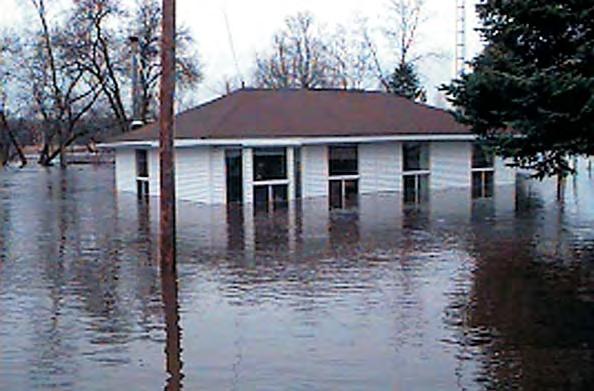
2 History The most severe flooding on record in Ontario occurred in October 1954 when Hurricane Hazel passed into southern Ontario. Eighty-one people died and damages were estimated at over $180 million. Following the devastating impact of Hurricane Hazel, a flood forecasting and warning system was established in the province. This system is managed by a committee made up of representatives from the OMNR, CAs and Environment Canada. It monitors watershed conditions including snow conditions, precipitation and flows, as well as issues flood messages. Several flood control facilities were significantly upgraded or constructed following Hurricane Hazel. Operational practices were designed to respond immediately to changing conditions. Regulations were put in place to limit and control future development and inappropriate land use activities in flood hazard areas. CAs continue to work with partners to prevent damages by floods. Flooding Flooding can be caused by a number of factors including excess snowmelt, irregular breakup of ice in rivers or along lakeshores or heavy rainfall. Water level surges on lakes or larger rivers can be caused by high winds. Areas that are vulnerable to flooding are called 'flood plains' or 'flood hazard lands'. These are lands adjoining a river, lake or other watercourse, which have been, or may be covered by floodwaters. In Ontario, flood plains are managed to protect residents from loss of life and to reduce property damage and to minimize social disruption in the event of a severe flood. Flood plains are all different. Some watercourses flood more frequently than others and some not at all. Some watercourses may take weeks to flood and others flood in a matter of hours or minutes, depending on local conditions and the severity of the event.
3 Flood Management Prevention - Informing planners and the general public about the risks of flooding promotes proper land use planning and regulation of development on flood plains thus preventing people from living and/or working in flood prone areas. Protection - In order to protect against flooding, CAs have constructed and maintain protective infrastructure such as dams and dykes or purchase lands located in hazardous areas. In the past, both the provincial and federal governments have contributed to these projects. Emergency Preparedness and Response - It is imperative that floods are forecasted to the extent possible. It is critical that municipalities prepare and implement plans which allow quick response to emergency situations created by flooding. What If A Flood Message Is Issued For Your Area? Take heed of the message issued. Be prepared to follow the advice and instructions of emergency response officials.
4 Flood Warnings CAs and OMNR are responsible for forecasting where and when flooding is likely to occur and issuing appropriate messages. Advance warning of an impending flood allows municipalities and other government agencies to put emergency response plans into operation, and if necessary, evacuate communities. Early notification to the public of developing or ongoing unsafe river and lake conditions allows individuals to take precautions. CAs issue three different types of flood messages: Flood Safety Bulletin/Advisory - Informs the public and municipalities that CAs are assessing the flood potential. Flood Advisory/Alert - Indicates the potential for flooding within specific watercourses or municipalities. Flood Warning - Warns that flooding is imminent or is occurring in specific watercourses or municipalities.
5 Role of Conservation Authorities in Flood Management and Forecasting CAs are responsible for predicting flows and water levels within their watersheds, operating flood control structures such as dams and disseminating flood warnings to local municipalities and agencies. CAs work with OMNR to provide advice to municipalities for the preparation of flood contingency plans and during the emergency response process. CAs and the OMNR use stream gauges, weather stations, surveys of snow conditions, meteorological forecasts and computer models to forecast potential floods. Snow Survey
6 For more specific information on flooding in your area, please contact your local Conservation Authority. You can find its contact information through Conservation Ontario s Web site at: Conservation Ontario P.O. Box 11, 120 Bayview Parkway, Newmarket, Ontario L3Y 4W3 Tel: info@conservation-ontario.on.ca Ontario Ministry of Natural Resources Information Centre General Inquiry: Toll Free: Peterborough: (705) Your local contact is: