Hackensack River Flood Reduction Study Update
|
|
|
- Clemence Alexander
- 5 years ago
- Views:
Transcription

1 Township of River Vale Hackensack River Flood Reduction Study Update November 11, 2013

2 Purpose of Study To Analyze Where Frequent Flooding Is Impacting Property and How It Might Be Reduced

3 Hackensack River Basin Township of River Vale

4 Flood Problem Areas

5 Flood Area 1

6 Flood Area 2

7 Flood Area 3
8 Flood Reduction Study Tasks Obtain Available Hackensack River Data Interview Officials Regarding Past Flood Events Identify Flood Threshold Locations and Frequencies Compare and Verify Available Data with Past Events Identify and Evaluate Hydraulic Effectiveness of Alternative Flood Reduction Plans and Combinations Recommend Effective Plans for Further Consideration and Analysis
9 Important Study Analyzes Hydraulic Effectiveness of Alternative Flood Reduction Plans Other Important Plan Aspects Must Also be Addressed, Including: Cost, Benefits, and Cost-to to-benefit Ratio Upstream and Downstream Impacts Environmental Impacts Property Acquisition Local and State Permits
10 Available Data Current NJDEP Delineation of Hackensack River Flood Plains Adopted in 1978 NJDEP Currently Developing New Flood Plain Delineation Using New Discharges, Field Surveys, and Topographic Mapping Flood Reduction Study Based upon New NJDEP Delineation Data and Computer Models NJDEP Expects to Release New Delineation Results by January 2014
11 Flood Frequency and Probability Flood Frequency Typically Expressed in Years Annual Flood Probability (%) = 100 Flood Frequency (Years) 100-Year Flood Annual Probability = 100 / 100 = 1% 25-Year Flood Annual Probability = 100 / 25 = 4% 10-Year Flood Annual Probability = 100 / 10 = 10% 2-Year Flood Annual Probability = 100 / 2 = 50%
12 Updated Flood Threshold Estimates Flood Area No. Existing Threshold Rate Existing Threshold Frequency Existing Threshold Probability 1 2,500 CFS+ 12 Years+ 8% 2 2,000 CFS+ 7 Years+ 14% 3 1,400 CFS+ 3 Years+ 33%
13 What Can Be Done? Reduce Water Levels by Increasing Waterway Size and Conveyance. Includes Channels, Bridges, Culverts, and Dams Reduce Water Levels by Reducing Waterway Flow by Storing Excess Flow Construct Barriers Between Existing Water Levels and Structures, Roads, and People Move Structures, Road, and People Away Above Existing Water Levels
14 Flood Plans Analyzed Structural Measures Construct Flood Walls Along River Construct River Bypasses Controlled Release from Lake Tappan and/or Oradell Reservoir Create Additional Storage Along River Increase Bridge Size and Flow Capacity Increase River Channel Size and Capacity
15 Flood Plans Analyzed Nonstructural Measures Flood-Proof Structures Purchase Flood-Prone Properties Develop Flood Warning System

16 Flood Walls FLOOD HAZARD AREA DESIGN FLOOD 10-YEAR FLOOD Flood wall to protect against more frequent storm events. BUT will not prevent flooding from large storm events!

17 Potential Flood Wall Locations
18 Construct Flood Walls Can be Hydraulically Effective Must Determine Required Wall Heights Locate Tie-In Locations and Wall Lengths Must Provide Interior Drainage Must Determine Effects of Lost Storage on Downstream Flows and Water Levels

19 Potential River Bypass #1 BYPASS #1
20 Construct Bypass #1 Flood Area Existing Flood Threshold 3 3 Years (33%) 2 7 Years (14%) 1 12 Years (8%) Future Flood Threshold* 6 Years (17%) 15 Years (7%) 12 Years (7%) *Results Based Upon 7-Foot High X 15-Foot Wide Bypass Culvert
21 Construct Bypass #1 Only Benefits Flood Areas 2 and 3 Existing Flood Risk Reduced in Half: Area 2: 14% Risk Reduced to 7% (7-Year Threshold Increased to 15-Year) Area 3: 33% Risk Reduced to 17% (3-Year Threshold Increased to 6-Year) 6 Improved Condition Risks/Thresholds Low Relative to Costs

22 Potential River Bypass #2 BYPASS #2
23 Construct Bypass #2 Flood Area Existing Flood Threshold 3 N/A (Downstream) 2 N/A (Downstream) 1 12 Years (8%) Future Flood Threshold* N/A (Downstream) N/A (Downstream) 18 Years (6%) *Results Based Upon 7-Foot High X 15-Foot Wide Bypass Culvert
24 Construct Bypass #2 Only Benefit Flood Area 1 Minimal Reduction in Existing Flood Risk: Existing 8% Risk Reduced to 6% (12-Year Threshold Increased to 18-Year) Improved Condition Risks/Thresholds Low Relative to Costs

25 Controlled Release from Lake Tappan
26 Updated Flood Threshold Estimates Flood Area No. Existing Threshold Rate Existing Threshold Frequency Existing Threshold Probability 1 2,500 CFS+ 12 Years+ 8% 2 2,000 CFS+ 7 Years+ 14% 3 1,400 CFS+ 3 Years+ 33%
27 Lower Pre-Flood Lake Tappan Improved Flood Threshold Flood Areas Required Lowering Depth Required Lowering Time* 25-Year 1, 2, and 3 6 Feet+ 5 Days+ 50-Year 1, 2, and 3 8 Feet+ 7 Days+ *Results Based Upon Existing Lake Spillway and Maximum 500 CFS Pre-Flood Release Rate
28 Pre-Flood Lake Tappan Release Requires Pre-Flood Release of Approximately 6 to 8 Feet of Stored Water Below Spillway Crest Pre-Flood Release Limited to Approximately 500 CFS to Prevent Downstream Flooding Pre-Flood Release must Begin Approximately 1 Week Before Flood
29 Potential Off-Line Storage Areas Potential Storage Areas
30 Potential Off-Line Storage Areas Due to Existing WS Elevations and Resulting Flooding, Additional Flood Storage can Only be Achieved via Floodplain Excavation From Analysis, Insufficient Additional Storage Areas and Volumes to Reduce Existing River Flows and Increase Existing Flood Thresholds Similar Results for On-Line Storage
31 Increase Bridge Size and Flow Capacity

32 Old Tappan Road Bridge

33 Westwood Avenue Bridge

34 Harriot Avenue Bridge
35 Existing 100-Year WS Profile Flood Area 3 Flood Area 2 Flood Area Year WS WS Rise Caused by Harriot Avenue Bridge WS Rise Caused by Westwood Avenue Bridge River Bottom or Invert WS Rise Caused By Old Tappan Road Bridge
36 Increase Bridge Capacity Bridge Harriot Avenue Westwood Avenue Old Tappan Road Flood Area Existing Flood Threshold 3 3 Years (33%) 2 7 Years (14%) 1 12 Years (8%) Future Flood Threshold 3 Years (33%) 15 Years (7%) 15 Years (7%) Note: Flood Area 3 Affected by Tailwater from Oradell Reservoir
37 Flood Area 3 Existing Flood Threshold = 3 Years Existing Flood Threshold = 6 Years
38 Effects of Oradell Reservoir River Condition/Plan Existing Remove Harriot Avenue Bridge Lower Oradell Tailwater Remove Bridge + Lower Oradell Cambridge Flood Threshold 6 Years (17%) 7 Years (14%) 10 Years (10%) 12-Years (8%) Clauss Flood Threshold 3 Years (33%) 3 Years (33%) 3 Years (33%) 3 Years (33%)
39 Flood Area 3 10-Year WS Profiles Cambridge Road Clauss Lane Existing 10-Year WS Remove Harriot Avenue Bridge Lower Oradell Tailwater Remove Bridge and Lower Tailwater
40 Effects of Oradell Reservoir Reservoir Only Affects Flood Area 3 Largest Effect in Cambridge Road Section Implications for Flood Reduction via Lower Water Levels: Flood Areas 1 and 2 Do Not Require Lower Reservoir Water Levels Flood Area 3 Will Require Lower Reservoir Water Levels
41 Increase Bridge Sizes Harriot Avenue: Only Effective with Lower Oradell Reservoir Water Levels Only Benefits Cambridge Road Portion of Flood Area 3 Minimal Reduction in Flood Risk Existing 17% Risk Reduced to 14% (6-Year Threshold Increased to 7-Year) 7
42 Increase Bridge Sizes Westwood Avenue: Benefits Flood Area 2 Existing Flood Risk Reduced in Half: Existing 14% Risk Reduced to 7% (7-Year Threshold Increased to 15-Year)
43 Increase Bridge Sizes Old Tappan Road: Benefits Flood Area 1 Minimal Reduction in Flood Risk Existing 8% Risk Reduced to 7% (12-Year Threshold Increased to 15-Year)
44 Increase River Channel Size 18 Different Channel Modification Plans Analyzed Included 6 Different Channel Widths With and Without Bridge Enlargements With and Without Oradell Reservoir Water Level Changes Reminder: Only Hydraulic Effects of Channel Modifications Evaluated
45 Increase River Channel Size Final Channel Plan: 100-Foot Wide Bottom Width from Harriot Avenue to Westwood Avenue 50-Foot Bottom Width from Westwood Avenue to Upstream Limit of Flood Area 1 at White Birch and Rehill Earthen Channel Like Existing 2:1 Channel Side Slopes
46 Increase River Channel Size River Condition/ Plan Existing Channel Modification Flood Area 3 (100 Channel) 3 Years (33%) 7 Years (14%) Flood Threshold Flood Area 2 (50 Channel) 7 Years (14%) 80 Years (1.3%) Flood Area 1 (50 Channel) 12 Years (8%) 80 Years (1.3%) Channel and Bridge Expansion 10 Years (10%) 100 Years (1%) 100 Years (1%) Channel, Bridge, and Lower Reservoir 100 Years (1%) 100 Years (1%) 100 Years (1%)
47 Increase River Channel Size Channel Bottom Widths: 100 Feet from Harriot to Westwood 50 Feet from Westwood to Rehill Provides 100-Year (1% Risk) Flood Threshold for All Three Flood Areas: Area 3 Requires Replacement of Harriot Avenue and Lower Oradell Areas 1 and 2 Requires Replacement of Westwood Avenue Bridge
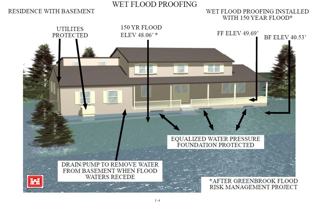
48 Wet Flood-Proofing
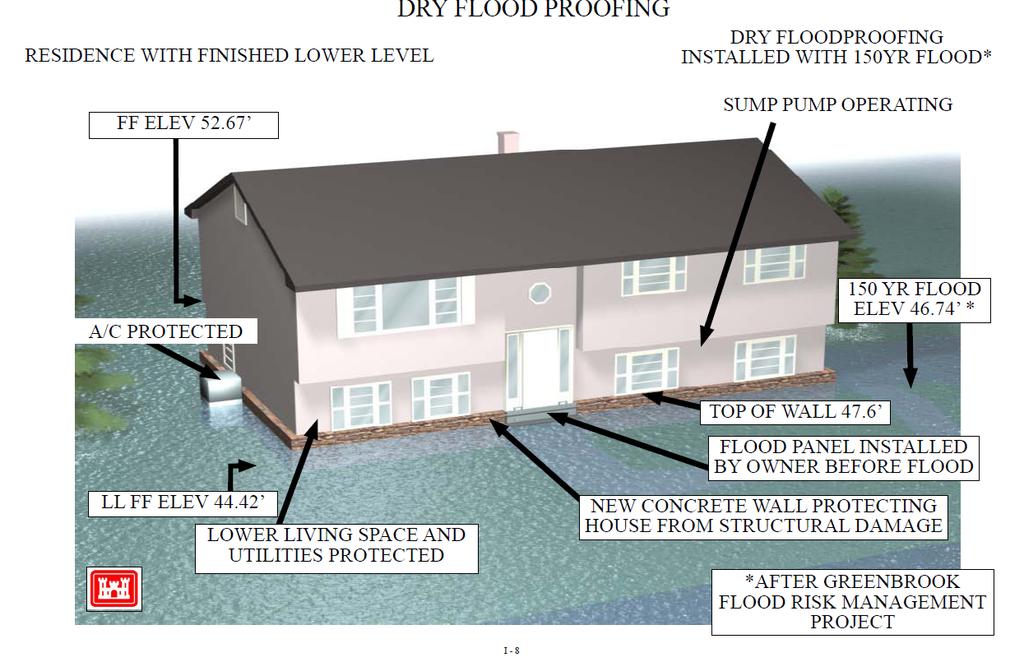
49 Dry Flood-Proofing
50 Flood-Proofing Can be Effective in Reducing Structure and Content Damage Cannot Reduce Property or Road Flooding Voluntary Participation Township can Develop Property and Structure Inventory from Computer Data and Topography Use Inventory Used to Prioritize Projects
51 Purchase Flood-Prone Properties FEMA Hazard Mitigation Assistance NJDEP Blue Acres Township Buyouts Total Equalized Value of Properties* Within 100-Year Flood Plain Affected by Severe and/or Frequent Flooding $34,725,829 $14,074,622 *Source: Municipal Tax Assessor Records
52 Purchase Flood-Prone Properties Township can Utilize New Computer Model Data and Topography to Develop Property and Structure Inventory Use Inventory Used to Prioritize Projects Voluntary Participation
53 Flood Warning System Can Provide Advanced Notice of Potential Flood Event Can Provide River and Flood Status and Updates During Event Can Provide Forecast River Crest and Flood Limits?
54 Flood Warning System Requires Water Level and Flow Gage(s) Requires Knowledge/Data of Past River Flood Events and River Response Computer Model of River Enhances System Coverage? Requires Communication System to Collect Data and Send Information

55 Enhanced Flood Warning System Hackensack River Gate at River Vale

56 Hackensack River at River Vale Flood Area 1: 2,500 CFS Flood Threshold Flood Area 2: 2,000 CFS Flood Threshold Flood Area 3: 1,400 CFS Flood Threshold


57 Enhanced Flood Warning System
58 Enhanced Flood Warning System Knowledge and Data of Past Floods and River Response Past Flood Data and Gage Thresholds from River Vale OEM Coordinator
59 Computer Model of River Flood Area 3 Flood Area 2 Flood Area 1 WS Profile Hackensack River at River Vale Gage
60 Enhanced Flood Warning System Communication System: Existing Township System Internet Reverse 911 Social Media

61 Enhanced Flood Warning System Effectiveness would be Significantly Increased if River Vale Gage Included in NOAA Forecasts Forecasts may be Difficult due to Upstream Lakes Township can Initiate Discussion with NOAA

62 Enhanced Flood Warning System Prepare and Distribute Township Flood Inundation Maps Particularly Effective if River Vale Gage Upgraded to NOAA Forecast Gage
63 Summary of Plan Analyses
64 Important Reminder Study Analyzed Hydraulic Effectiveness of Alternative Flood Reduction Plans Other Important Plan Aspects Must Also be Addressed, Including: Cost, Benefits, and Cost-to to-benefit Ratio Upstream and Downstream Impacts Environmental Impacts Property Acquisition Local and State Permits
65 Plans Investigated Flood Walls Bypasses Pre-Flood Lake Tappan Release On & Off-Line Storage Increase Bridge Sizes Increase Channel Size Flood Proofing Purchase Flood-Prone Properties Enhanced Flood Warning System
66 Study Summary Study Objective: To Identify Hydraulically Effective Concept Plans to Reducing Flooding Prior to Addressing Non- Hydraulic Issues. Hydraulically Effective Plans: Floodwalls Channel and Bridge Expansions Flood-Proofing Property Buyouts Enhanced Flood Warning System
67 Recommended Plans for Further Investigation Purchase of Flood Prone Properties Flood Proofing Flood Warning System Replace Westwood Ave & Old Tappan Road Bridges (IF funding available)
68 Looking Ahead Potential Future Partners: River Vale Residents Bergen County United Water NJDEP Bergen SWAN FEMA Army Corps of Engineers
69 Township of River Vale Hackensack River Flood Reduction Study Update Q & A