Workshop Southern Water Use Caution Area Recovery Strategy and Upper Peace River Projects
|
|
|
- Hilary Alexander
- 5 years ago
- Views:
Transcription
1 Workshop Southern Water Use Caution Area Recovery Strategy and Upper Peace River Projects Governing Board and Peace River, Alafia River and Manasota Basin Boards September 29, 2009
2 Overview of Workshop Expectations Bruce C. Wirth, P.E., Deputy Executive Director
3 SWUCA Chronology of Key Activities

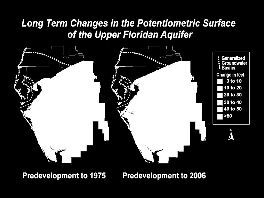
4 SWFWMD Boundaries 1974 & Present
5 1970s o Florida Water Resources Act - Peace River Water Use Caution Area o Water Use Permitting o Manatee, Sarasota and portions of Highlands and Polk Counties added o Ridge 1 Study
6 1980s o 1987/ Designated ETB, HR, and NTB Areas of Special Concern o Initiated the Ridge 2 Study o Initiated Water Resource Assessment Projects for ETB and NTB o Declared ETB and HR WUCAs
7 o 1990/1991 ETB, NTB, and HR WUCA Rules o 1992 Declared SWUCA o 1994 SWUCA 1 Rules and NWSI o 1996/1997 MFLs Legislation o Set MFLs in NTB o Annual priority list and schedule o Structural alterations o Recovery strategy 1990s o 1997 SWUCA 1 order received and appealed
8 2000s o 2000 District prevails on SWUCA 1 appeal more appeals o 2002 Kick-Off Board meetings for SWUCA 2 primarily to address MFL legislation o 2003 Implement SWUCA 1 rules o Increased conservation and reporting requirements o Reduction in permitted irrigation quantities o Governing Board adopts SWUCA 2 Recovery Strategy o 2007 SWUCA 2 Recovery Strategy became effective
9 Minimum Flows and Levels Statutory Requirements
10 MFL Statutory Requirements o Establish Minimum Flows or Levels for regionally significant water resources using science. o Considerations in establishment: Changes and structural alterations to watersheds. o Exclusions: Water bodies that no longer serve historical hydrologic functions. Recovery may not be economically or technically feasible. o Expeditiously implement recovery strategy o Achieve recovery as soon as practicable o Recovery strategy shall include phasing o MFLs: Reevaluated periodically and revised as needed
11 Review of Goals, Guiding Principles and Major Elements of the 2006 SWUCA Recovery Strategy
12 Goals o Restore minimum levels to priority lakes in the Ridge Area by 2025 o Restore minimum flows to the upper Peace River by 2025 o Reduce the rate of saltwater intrusion by achieving the minimum aquifer level for saltwater Intrusion by 2025; once achieved, seek further reductions and ultimate stabilization o Ensure sufficient water supplies for all existing and projected reasonable beneficial uses
13 Guiding Principles o Contribute to management & resource recovery o Protect investments of existing WUP holders o Allow for economic expansion o Based on best available peer reviewed science o Minimize the need for rule revisions o Financial and regulatory incentives o Implemented in a practical timeframe o Consistent with other statewide strategies o Strategy is designed to meet these principles *Periodic review and update of plan. Every 5 years.
14 Six Major Elements 1. Regional water supply planning 2. Use of existing rules 3. Enhancements to existing rules 4. Financial incentives to develop AWS 5. Develop projects to reestablish MFLs 6. Resource monitoring
15 Questions?
16 SWFWMD Governing Board Workshop SWUCA and Upper Peace River Water Resource Issues By Ron Basso, P.G. September 29, 2009
17 Water Resource Issues in the Southern Water Use Caution Area Resource concerns Background Groundwater impacts Upper Peace River Groundwater cutbacks to achieve MFLs

18 Resource Concerns NTB SWUCA


19

20

21
22

23


24

25 Losing Stream

26
27

28 Kissengen Spring ceased flow
29 Ground-Water Withdrawals (Mgal/day) Based on ground-water levels and excluding Charlotte County Estimated Use 10 Yr Moving Avg SWUCA: Estimated Ground-Water Use SWFWMD Begins Issuing WUPs Kissengen Spring Ceases Continuous Flow SWUCA Groundwater Withdrawals = 320 mgd
30 Questions?
31 SWFWMD Governing Board Workshop SWUCA Recovery Strategy and the Upper Peace River Recovery Projects By Mark A. Hammond, P.E., Director September 29, 2009
32 SWUCA Recovery Strategy Governing Board approved in 2006 Effective January 2007 Achieve MFLs by 2025 Adaptive management approach Continue to monitor Annual report to Governing Board Reevaluate every five years Adjust as needed
33 Six Major Elements of SWUCA Recovery Strategy 1. Regional water supply planning 2. Use of existing rules 3. Enhancements to existing rules 4. Financial incentives to develop AWS 5. Develop projects to reestablish MFLs 6. Resource monitoring
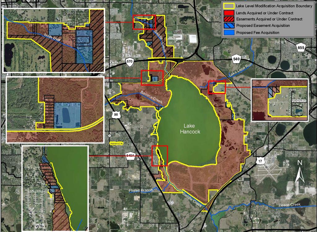
34 Upper Peace River Recovery Projects Lake Hancock lake level modification Lake Hancock outfall treatment Stream flow losses in karst features Peace Creek watershed Reconnect lands Reservoir
35 Upper Peace River Recovery Projects Lake Hancock lake level modification Lake Hancock outfall treatment Stream flow losses in karst features Peace Creek watershed Reconnect lands Reservoir

36
37 January 2002 Governing Board workshop Reservoir feasibility study March 2002 Financial engine December 2002 SWUCA Chronology Upper Peace River MFL peer review Funding for USGS karst features study
38 January 2003 Federal funding assistance packet February 2003 Lake Hancock Lake Level Modification Project April 2003 Design of reservoir on mine lands Initiate land and easement acquisition Survey old phosphate lands for potential reservoir June 2003 SWUCA Chronology Lake Hancock outfall treatment project
39 May, June & July 2004 Lake Hancock Lake Level Modification Project Benefits and impacts Sink losses Floodplain Land acquisition Mitigation & permitting October 2004 Preliminary design at feet Prepare conceptual ERP application December 2004 SWUCA Chronology Interim USGS report on karst features
40 March 2005 Projects to restore MFLs for upper Peace River June, August & November, 2005 Lake Hancock Outfall Treatment Project Preliminary cost estimates Evaluation and ranking of various treatment technologies February 2006 SWUCA Chronology Lake Hancock Outfall Treatment Project Adopted 27% N load reduction Approved wetland treatment as primary option
41 March 2006 MFLs and SWUCA Recovery Strategy September 2007 Lake Hancock Lake Level Modification Project Authorized project Resolution authorizing eminent domain Amended Florida Forever work plan ($41 million) Designated $79 million in general fund Construction budget consistent with financial engine October 2008 SWUCA Chronology First annual update

42
43
44 Upper Peace River Watershed 2004 DOQs 2002 Landsat
45 Upper Peace River Watershed Lake Hancock 2004 DOQs 2002 Landsat

46 Upper Peace River Watershed Lake Hancock Peace Creek 2004 DOQs 2002 Landsat
47 Upper Peace River Watershed Lake Hancock Peace Creek Karst Features Reconnect Lands Reservoir 2004 DOQs 2002 Landsat
48 Upper Peace River Recovery Projects Lake Hancock lake level modification Lake Hancock outfall treatment Stream flow losses in karst features Peace Creek watershed Reconnect lands Reservoir

49 Lake Hancock Lake Level Modification Project Outfall Treatment
50

51 Structure P-11
52
53
54 Secondary Benefits Complete Lake Hancock section of the Upper Peace River to Tenoroc (Green Swamp) greenway corridor with acquisition of approximately 7,000 to 8,400 acres around Lake Hancock Opportunities for partnerships with Polk County and City of Bartow for recreation Preserve approximately 4,800 acres of floodplain Restore historic levels for a 4,500-acre lake Improve approximately 1,000 acres of wetlands around lake Provide land for a 1,000-acre treatment wetland to reduce nitrogen loading by 27% Provides restoration and/or mitigation opportunities
55 Lake Hancock Lake Level Modification Land Acquisition to date $ 120 M Land Acquisition remaining $ 30 M Structure (Des/Construction) $ 6 M Mitigation (Des/Construction) $ 14 M Total $ 170 M Note: Potential surplus of lands could offset some costs
56 Upper Peace River Recovery Projects Lake Hancock lake level modification Lake Hancock outfall treatment Stream flow losses in karst features Peace Creek watershed Reconnect lands Reservoir
57 Karst Features 2004 DOQ s 2002 Landsat

58 USGS-SWFWMD Cooperative Funding Study Effect of Karst Development On Peace River Flow

59
 Catacombs Peace River near Ba rtow (7) Midway (8) EXPLANATION KARST FEATURE-- Name and number ORIENTATION GAGING STATION-- Name and number Elephant Graveyard (9) Crevasses Paternoster")
60 Peace River at Bartow (1) Extent of flow on May 20, 2002 N Cypress Root Peace River Corbett (3) Wabash (2) Cypress Root Ledges (6) Harley Jackson Cook's Ripple (4) Extent of flow on June 25, 2002 Fricano (5) Catacombs Peace River near Ba rtow (7) Midway (8) EXPLANATION KARST FEATURE-- Name and number ORIENTATION GAGING STATION-- Name and number Elephant Graveyard (9) Crevasses Paternoster Complex Gator Log Dover Sink (10) Miles Kilometers Extent of upstream flow from June 19-24,2002
 Catacombs Peace River near Ba rtow (7) Midway (8) EXPLANATION KARST FEATURE-- Name and number ORIENTATION GAGING STATION-- Name and number Gator Log Elephant Graveyard (9) Crevasses Paternoster")
61 Peace River at Bartow (1) Fricano Extent of flow on May 20, 2002 N Peace River Corbett (3) Wabash (2) Cypress Root Ledges (6) Harley Jackson Cook's Ripple (4) Extent of flow on June 25, 2002 Fricano (5) Catacombs Peace River near Ba rtow (7) Midway (8) EXPLANATION KARST FEATURE-- Name and number ORIENTATION GAGING STATION-- Name and number Gator Log Elephant Graveyard (9) Crevasses Paternoster Complex Dover Sink (10) Miles Kilometers Extent of upstream flow from June 19-24,2002
 Catacombs Peace River near Ba rtow (7) Midway (8) EXPLANATION KARST FEATURE-- Name and number ORIENTATION GAGING STATION-- Name and number Gator Log Elephant Graveyard (9) Crevasses")
62 Peace River Corbett (3) Peace River at Bartow (1) Extent of flow on May 20, 2002 Wabash (2) Cypress Root N The Ledges Ledges (6) Harley Jackson Cook's Ripple (4) Extent of flow on June 25, 2002 Fricano (5) Catacombs Peace River near Ba rtow (7) Midway (8) EXPLANATION KARST FEATURE-- Name and number ORIENTATION GAGING STATION-- Name and number Gator Log Elephant Graveyard (9) Crevasses Paternoster Complex Dover Sink (10) Miles Kilometers Extent of upstream flow from June 19-24,2002
 Catacombs Peace River near Ba rtow (7) Midway (8) EXPLANATION KARST FEATURE-- Name and number ORIENTATION GAGING STATION-- Name and number Elephant Graveyard (9) Crevasses Paternoster")
63 Peace River Corbett (3) Peace River at Bartow (1) Extent of flow on May 20, 2002 Wabash (2) Cypress Root N Crevasses Ledges (6) Harley Jackson Cook's Ripple (4) Extent of flow on June 25, 2002 Fricano (5) Catacombs Peace River near Ba rtow (7) Midway (8) EXPLANATION KARST FEATURE-- Name and number ORIENTATION GAGING STATION-- Name and number Elephant Graveyard (9) Crevasses Paternoster Complex Gator Log Dover Sink (10) Miles Kilometers Extent of upstream flow from June 19-24,2002
 Catacombs Peace River near Ba rtow (7) Midway (8) EXPLANATION KARST FEATURE-- Name and number ORIENTATION GAGING STATION-- Name and number Elephant Graveyard (9) Crevasses Paternoster")
64 Peace River Corbett (3) Peace River at Bartow (1) Extent of flow on May 20, 2002 Wabash (2) Cypress Root N Dover Sink Ledges (6) Harley Jackson Cook's Ripple (4) Extent of flow on June 25, 2002 Fricano (5) Catacombs Peace River near Ba rtow (7) Midway (8) EXPLANATION KARST FEATURE-- Name and number ORIENTATION GAGING STATION-- Name and number Elephant Graveyard (9) Crevasses Paternoster Complex Gator Log Dover Sink (10) Miles Kilometers Extent of upstream flow from June 19-24,2002


65 +10.5 cfs -5.1 cfs cfs

66 South
67
68
69
70 Upper Peace River Recovery Projects Lake Hancock lake level modification Lake Hancock outfall treatment Stream flow losses in karst features Peace Creek watershed Reconnect lands Reservoir
71 Peace Creek 2004 DOQs 2002 Landsat

72 Peace Creek Canal

73 Peace Creek Canal

74 Peace Creek Canal

75 Peace Creek 2004 DOQs 2002 Landsat

76 Peace Creek 2004 DOQs 2002 Landsat
77 Upper Peace River Recovery Projects Lake Hancock lake level modification Lake Hancock outfall treatment Stream flow losses in karst features Peace Creek watershed Reconnect lands Reservoir

78 2004 DOQs 2002 Landsat

79 Reconnect Lands 2004 DOQs 2002 Landsat

80 Reconnect Lands
81 Upper Peace River Recovery Projects Lake Hancock lake level modification Lake Hancock outfall treatment Stream flow losses in karst features Peace Creek watershed Reconnect lands Reservoir
82 Reservoir Survey of old mine lands 99 parcels evaluated 400 acres or greater Within one mile of the Peace River/tributary 10 sites ranked CS-11 top ranked Largest site Dams still intact
83 Potential Reservoir Sites 2004 DOQs 2002 Landsat

84
85 CS-11 Site Studies Topographic Survey to determine storage volume Geotechnical investigations to verify integrity of berms Comparison of retrofitting CS-11 with construction of a reservoir on a green field site

86

87
88 CS-11 Conceptual Cost Estimates Land Acquisition $ 10.2 M Design/Construction $152.8 M Total $163 M

89 Upper Peace River Recovery Projects Questions?