Public Notice ISSUED: 16 February 2018 EXPIRES: 19 March 2018
|
|
|
- Vanessa Morrison
- 5 years ago
- Views:
Transcription

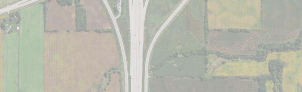
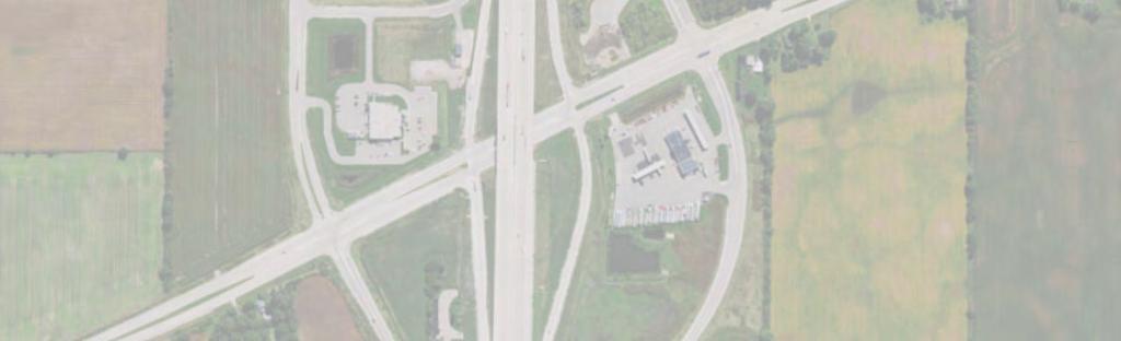
1 APPLICANT: Wisconsin Department of Transportation Public Notice ISSUED: February 08 EXPIRES: 9 March 08 REFER TO: MVP ANM SECTION:0 - Clean Water Act. APPLICATION FOR PERMIT TO permanently discharge dredged or fill material in a total of 9.8 acres of waters of the U.S. and to temporarily discharge dredged or fill material within 0.0 acre of wetland. These discharges would facilitate the reconstruction of the Interstate (I-) and County E, County KR, and WIS interchanges in the Village of Mount Pleasant, Towns of Paris, Yorkville, and Sommers in Racine and Kenosha Counties.. SPECIFIC INFORMATION PROJECT LOCATION: The project site is located along. miles of I- from the WIS in Kenosha County to WIS 0 in Racine County. The project site is located in Sections 8, 9, 0,, Township North, Range East; Sections,,,, Township North, Range East; Sections,,,, Township North, Range East; and Section,, 8, 9, Township North, Range East; Racine and Kenosha Counties, Wisconsin. See the attached drawings MVP ANM, Figures to 9, for more information. DESCRIPTION OF PROJECT: The proposed project includes the expansion of I- to 8 lanes (one additional lane in each direction) and reconstruction County E, County KR, and WIS interchanges. The County E and County KR interchanges are being reconstructed as tight diamond interchanges, while the WIS interchange is being reconstructed in a similar configuration to its existing design of partial cloverleaf. The County KR, WIS, and WIS 0 crossroads are also being reconstructed as part of the project. Throughout the project area, 0 pipe culvert crossings would be replaced with concrete of similar diameter along I- and would connect to pipes already constructed on the frontage roads. In addition, new culverts will be installed and existing culverts will be removed. The Federal Highway Administration (FHWA) is the lead federal agency for project review. Several environmental documents were previously completed for both the I- reconstruction and interchange and crossroads reconstruction. An I- Corridor Interchange Improvements Environmental Assessment (EA) was prepared in 99 and re-evaluated in 00 (ftp://ftp.dot.wi.gov/dtsd/hcci/projectdocuments/00/question%0%/ea/eareevalall -000.pdf) for all of the interchanges and crossroads within the project area. The I- North- South Final Environmental Impact Statement (EIS) was prepared in 008 and addressed the I- mainline segments within the project area ( A re-evaluation of the project area within both documents was completed in May and October of 0. QUANTITY, TYPE, AND AREA OF FILL: The proposed project is currently estimated to impact approximately 0. acre of unnamed tributaries to Kilbourn Road Ditch and will result in the filling and permanent loss of approximately 9. acres of wetland. The impacted wetlands include.0 acres of shallow marsh,. acres of wet meadow, 0. acre of wooded swamp, and 0.0 acre of shrub scrub. The project also includes a temporary impact to 0.0 acre of shallow marsh to locate a drain tile.
2 Regulatory Branch (File No. MVP ANM) VEGETATION IN AFFECTED AREA: The shallow marsh and wet meadow wetlands consists mostly of roadside ditches throughout the project area. The vegetation in the shallow marsh and wet meadow wetlands are primarily invasive species, including narrowleaf cattail, reed canary grass, and phragmites. The wooded swamp is dominated by box elder, buckthorn, reed canary grass, and narrowleaf cattail. The shrub scrub is dominated by narrowleaf cattail, reed canary grass, and sandbar willow. SOURCE OF FILL MATERIAL: Any off-site fill utilized for the project would come from an existing commercial source and would be free of any known contaminants. SURROUNDING LAND USE: Most of the land use adjoining I- from WIS to the northern edge of the project is commercial development. Agricultural fields with light commercial development dominates the land use south of WIS to WIS. THE FOLLOWING POTENTIALLY TOXIC MATERIALS COULD BE USED AT THE PROJECT SITE: The project does not propose to use toxic materials, but fluid used in construction equipment may pose a slight risk. All equipment would be maintained and stored according to the Erosion Control Implementation Plan provided by the contractor. THE FOLLOWING PRECAUTIONS TO PROTECT WATER QUALITY HAVE BEEN DESCRIBED BY THE APPLICANT: The proposed project would be conducted in compliance with the state s erosion control and stormwater best management practices to prevent sediment from leaving the site during and after construction. MITIGATION: The applicant proposes to fulfill federal compensatory mitigation requirements by debiting.0 wet meadow credits at the WisDOT Jacobson bank site and. riparian emergent credits at the WisDOT Hope Marsh Phase II.. FEDERALLY-LISTED THREATENED OR ENDANGERED WILDLIFE OR PLANTS OR THEIR CRITICAL HABITAT None were identified by the applicant or are known to exist in the permit area. However, the proposed project is within the known or historic range of the following Federally-listed species: Northern Long-Eared Bat (Threatened) Hibernates in caves and mines swarming in surrounding wooded areas in autumn. Roosts and forages in upland forests during spring and summer. Eastern Prairie Fringed Orchid (Threatened) Occurs in a variety of habitats, from mesic prairie to wetland such as sedge meadow, marsh edges, and bogs. Requires grass habitat with little or no woody encroachment. Page of
3 Regulatory Branch (File No. MVP ANM) The FHWA as the lead federal agency consulted with the U.S. Fish and Wildlife Service on these species. Any additional comments received as a result of this notice concerning Federally-listed threatened or endangered species and their critical habitat will be considered in our final assessment of the project.. JURISDICTION This application is being reviewed in accordance with the practices for documenting Corps jurisdiction under Sections 9 & 0 of the Rivers and Harbors Act of 899 and Section 0 of the Clean Water Act identified in Regulatory Guidance Letter -0.. STATE SECTION 0 WATER QUALITY CERTIFICATION WATER QUALITY CERTIFICATION. This Public Notice has been sent to the Wisconsin Department of Natural Resources and is considered by the District Engineer to constitute valid notification to that agency for Section 0 water quality certification. A permit will not be granted until the Wisconsin Department of Natural Resources has issued or waived Section 0 certification.. HISTORICAL/ARCHAEOLOGICAL FHWA is the lead federal agency for project review pursuant to Section 0 of the National Historic Preservation Act. The May and October 0 re-evaluation of the EA and EIS included a field investigation and review of aerial images to determine whether there are any new structures eligible for the National Register of Historic Places (NRHP) that were not eligible in 00 (during the re-evaluation of the 99 EA) or in 008 (EIS). In addition, a search of the Wisconsin Historic Preservation Database (WHPD) indicated that there are no newly recorded archaeological sites located within the project area. The WisDOT Cultural Resources Team determined no new impacts to cultural resources were identified, therefore, no additional Section 0 coordination was needed with the State Historic Preservation Office (SHPO).. PUBLIC HEARING REQUESTS Any person may request, in writing, within the comment period specified in this notice, that a public hearing be held to consider this application. Requests for public hearings shall state, in detail, the reasons for holding a public hearing. A request may be denied if substantive reasons for holding a hearing are not provided or if there is otherwise no valid interest to be served. 8. PUBLIC INTEREST REVIEW The decision whether to issue a permit will be based on an evaluation of the probable impact, including cumulative impacts, of the proposed activity on the public interest. That decision will reflect the national concern for both protection and utilization of important resources. The benefit which reasonably may be expected to accrue from the proposal must be balanced against its reasonably foreseeable detriments. All factors which may be relevant to the proposal will be considered, including the cumulative effects. Among those are conservation, economics, aesthetics, general environmental concerns, wetlands, cultural values, fish and wildlife values, flood hazards, floodplain values, land use, navigation, shoreline erosion and accretion, recreation, water supply and conservation, water quality, energy needs, safety, food and fiber production and, in general, the needs and welfare of the people. Environmental and other documents will be available for review in the St. Paul District Office. Page of
4 Regulatory Branch (File No. MVP ANM) The Corps of Engineers is soliciting comments from the public; Federal, State, and local agencies and officials; Indian tribes; and other interested parties in order to consider and evaluate the impacts of this proposed activity. Any comments received will be considered by the Corps of Engineers to determine whether to issue, modify, condition, or deny a permit for this proposal. To make this decision, comments are used to assess impacts on endangered species, historic properties, water quality, general environmental effects, and the other public interest factors listed above. Comments are used in the preparation of an Environmental Assessment and/or an Environmental Impact Statement pursuant to the National Environmental Policy Act. Comments are also used to determine the need for a public hearing and to determine the overall public interest of the proposed activity. 0. COASTAL ZONE MANAGEMENT The Wisconsin Coastal Management Program (WCMP) in the Department of Administration is inviting public comment regarding this project. The WCMP may conduct a Federal consistency review to verify that the project will comply with State policies in Wisconsin's coastal zone. Further information may be obtained from the Federal Consistency Coordinator at: Wisconsin Coastal Management Program, P.O. Box 88, Madison, WI 0-88; (08) -98. Any comments on whether or not this proposed project complies with the State enforceable policies should be received within 0 days by the Federal Consistency Coordinator. 9. REPLIES/COMMENTS Interested parties are invited to submit to this office written facts, arguments, or objections within 0 days of the date of this notice. These statements should bear upon the suitability of the location and the adequacy of the project and should, if appropriate, suggest any changes believed to be desirable. Comments received may be forwarded to the applicant. Replies may be addressed to: U.S. Army Corps of Engineers Attn: April Marcangeli 0 N. Sunnyslope Road, Suite 9 Brookfield, Wisconsin 00 Or, IF YOU HAVE QUESTIONS ABOUT THE PROJECT, call April Marcangeli at the Brookfield office of the Corps, telephone number To receive Public Notices by , go to: and add your information in the New Registration Box. Todd Vesperman Chief, Southeast Section Enclosures: MVP ANM Figures through 9 NOTICE TO EDITORS: This public notice is provided as background information and is not a request or contract for publication. Page of


5 MVP ANM Figure of North Project Limit Louis Sorenson Rd Highway 0 Study Area 8th Rd Braun Rd Highway Study Area Racine County Kenosha County KR A KR Racine County Kenosha County E County KR Study Area South Project Limit E Mainline Study Area County E Study Area W D E PA R TM E NT IS CONS OF TRANSPORTAT ION IN U.S. Department of Transportation Federal Highway Administration I- North-South Corridor (Kenosha and Racine Coun es) Study Area SL080MKE _INS_RK_RacineCty_StudyArea_v.0.0
6 MVP ANM Figure of 9 Completed Re-evaluation Study Area (November 0 LET) 0 0 Wis Crossroad North Project Limit 9 Wis to Wis Mainline 8 Wis Interchange 00-- Mainline & Ramps 00-- Crossroad Braun Rd County KR to Wis Mainline Racine County Kenosha County KR County KR Interchange 0-0- Mainline & Ramps 0-0- Structure &Crossroad th St County E to County KR Mainline E County E Interchange 00-- Mainline & Ramps South Project Limit Wis to County E Mainline W D E PA R TM E NT IS CONS OF TRANSPORTAT ION IN U.S. Department of Transportation Federal Highway Administration I- North-South Corridor (Kenosha and Racine Coun es) Study Area SL080MKE _INS_RK_RacineCty_StudyArea_v.08.0


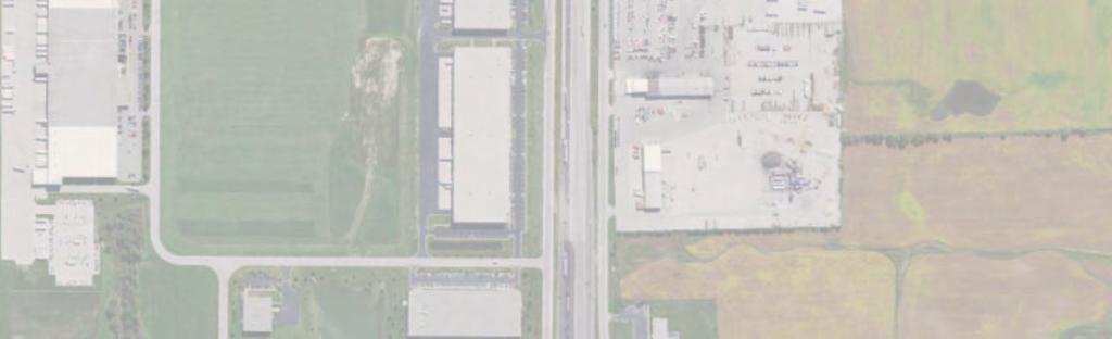
7 MVP ANM Figure of 9 0 Washington Ave W- SE Frontage Rd W-9-K W- W-9-J Grandview Pkwy W-9-I W9-C W-9-B Grandview Pkwy W W- W- W-9- W- W- W- 0 0 W-# Note: 0 Imagery source: Esri ArcGIS Online World Imagery \\MKEFPP0\PROJ\GIS\WISDOT\I-_NORTH_SOUTH_CORRIDOR\MAPS\REPORT\FIGUREXX_I_NS_WETLANDS.MXD JHANSEN //0 8::8 AM Wetland Location Map of


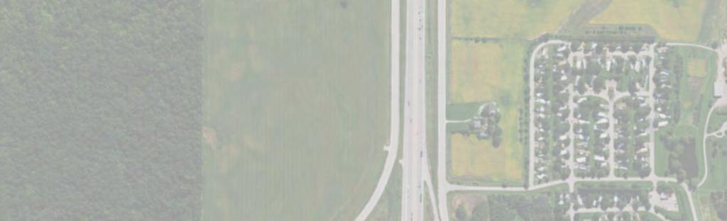
8 MVP ANM Figure of 9 W- W- W-9-A W9-A Leetsbir Rd W-8 W-0 W-9 W- W- W-0 Louis Sorenson Rd th Rd W- W- W-0- W- W-- W- W- W-0 W-9 W- 8th Rd W-9 W-8 W- W- W-8 W- W- W- W- W- W- W-8 W-- W- W-9 W- W- W-9 W- W- W- W- W- W-0 W-A W- W- 0 0 W-# Note: 0 Imagery source: Esri ArcGIS Online World Imagery \\MKEFPP0\PROJ\GIS\WISDOT\I-_NORTH_SOUTH_CORRIDOR\MAPS\REPORT\FIGUREXX_I_NS_WETLANDS.MXD JHANSEN //0 8::8 AM Wetland Location Map of


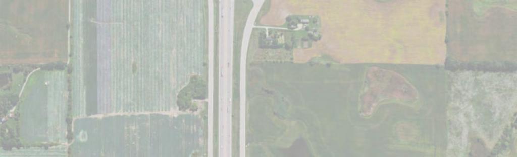
9 MVP ANM Figure of 9 W- W-A W-- W-- W- W-9 W- W-8 W- W- W-- W-9 W--D W-- W- W--C W-0 W- W--A W-B Braun Rd W- W- W- W-8 W-- W--A W- W--B W W-# Note: 0 Imagery source: Esri ArcGIS Online World Imagery \\MKEFPP0\PROJ\GIS\WISDOT\I-_NORTH_SOUTH_CORRIDOR\MAPS\REPORT\FIGUREXX_I_NS_WETLANDS.MXD JHANSEN //0 8::8 AM Wetland Location Map of


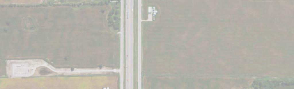
10 MVP ANM Figure of 9 W- W-- W-A W- W- W- W- W- W- W- W-0 W-0 W-99 W-00 W- W- W- W- W-0 W-0 W- W- W-0 W-0 W- W-0 W-0 KR W- W-98 W-99 W- W- W- W- W- W-0 W- W-08 W- W- W-8 W- nd Pl W- W- W- 0 0 W-# Note: 0 Imagery source: Esri ArcGIS Online World Imagery \\MKEFPP0\PROJ\GIS\WISDOT\I-_NORTH_SOUTH_CORRIDOR\MAPS\REPORT\FIGUREXX_I_NS_WETLANDS.MXD JHANSEN //0 8::8 AM Wetlands Location map of


11 MVP ANM Figure of 9 W-9 W- W- W- W-9 W- A W-0 W-0 W- W-9 W- W-8 W W -# Note : 0 Im agery source : Esri ArcGIS Online W orld Imagery \\MKEFPP0\PROJ\GIS\WISDOT\I-_NORTH_SOUTH_CORRIDOR\MAPS\REPORT\FIGUREXX_I_NS_WETLANDS.MXD JHANSEN //0 8::8 AM W etland Location map of


12 MVP ANM Figure 8 of 9 W- W- W-8 W- W-0 W-8 W-9 W-89 W- W-9 W-9 W-9 E W-9 W- W-89 W-8 W-8 W-88 W-8 W-88 W-88 W-8 W-90 W-90 W-8 W-9 W-9 W-09 W-8 W-80 W-8 W-8 W- W-9 W-8 W- W- 0 0 W -# Note : 0 Im agery source : Esri ArcGIS Online W orld Imagery \\MKEFPP0\PROJ\GIS\WISDOT\I-_NORTH_SOUTH_CORRIDOR\MAPS\REPORT\FIGUREXX_I_NS_WETLANDS.MXD JHANSEN //0 8::8 AM Wetland Location Map of


13 MVP ANM Figure 9 of 9 W- W- W- W- W-9 W-8 W-9 W-9 W-9 W- W-0 W- 0 0 W -# Note : 0 Im agery source : Esri ArcGIS Online W orld Imagery \\MKEFPP0\PROJ\GIS\WISDOT\I-_NORTH_SOUTH_CORRIDOR\MAPS\REPORT\FIGUREXX_I_NS_WETLANDS.MXD JHANSEN //0 8::8 AM W etland Location Map of