October 2015 Utilizing a County-Owned Golf Course for Watershed Restoration in Gwinnett County, GA
|
|
|
- Melina McBride
- 5 years ago
- Views:
Transcription


1 October 2015 Utilizing a County-Owned Golf Course for Watershed Restoration in Gwinnett County, GA Arvind Narayanan, P.E.*, CFM, Water Resources Engineer

2 Overview Project Identification Project Implementation: Phase I Stream Restoration and LID Project Location Phase II BMP Restoration and Stream stabilization Project Benefits 2


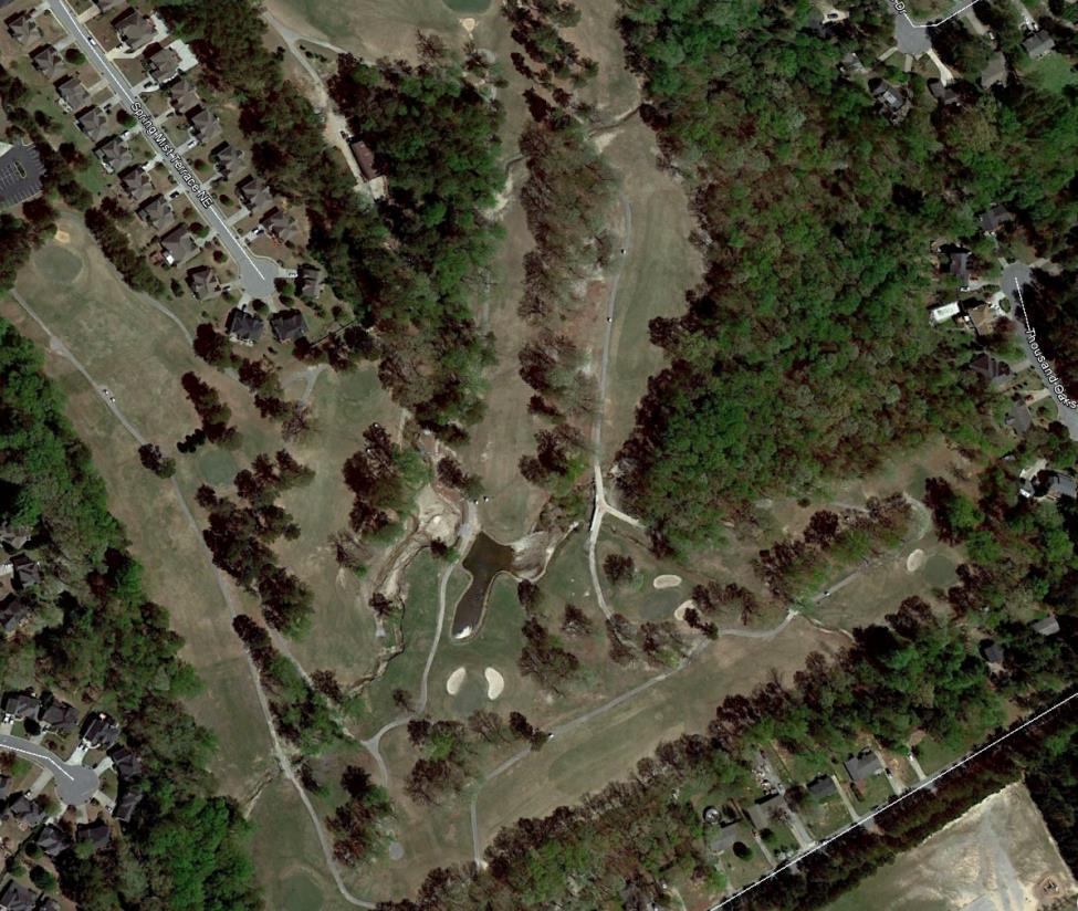


3 Historic Aerials 3 4/2008 4/2010 1/2014
 UYR WIP Identified 183 Capital Improvement")
4 Project Background Collins Hill Golf Course Parcel owned by Gwinnett County Parks and Recreation Project identified by Gwinnett County Department of Water Resources Identified as 4 separate projects in Upper Yellow River WIP (2003) UYR WIP Identified 183 Capital Improvement projects 4


5 o Project Background 2 Stream Restoration projects o 2 BMP Restoration projects 5

6 Watershed Characteristics Drainage area: 0.65 sq.mi. 16% impervious Wildcat creek upstream (500 LF): 0.30 sq.mi. Wildcat creek downstream (350 LF): 0.65 sq.mi. East pond inlet: 0.22 sq.mi. West pond inlet: 0.40 sq.mi. Bioretention area: 4.4 acres Completely developed watershed, predominantly low density residential land use 6
 Average depth <1 ft. NWL at 1,016.57 ft.")
7 Existing Conditions - Pond 0.45-acre East pond 1.14-acre West pond (breached) 0.16-acre forested/shrub wetland (once open water) Average depth <1 ft. NWL at 1, ft. 140-acre project site owned by Gwinnett County 7


8 Existing Conditions - Pond 8


9 Existing Conditions - Pond 12/ / /2012 9


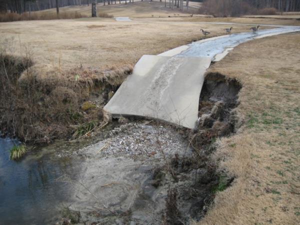
10 Existing Conditions - Stream 4/18/


11 Existing Conditions - Stream 4/18/
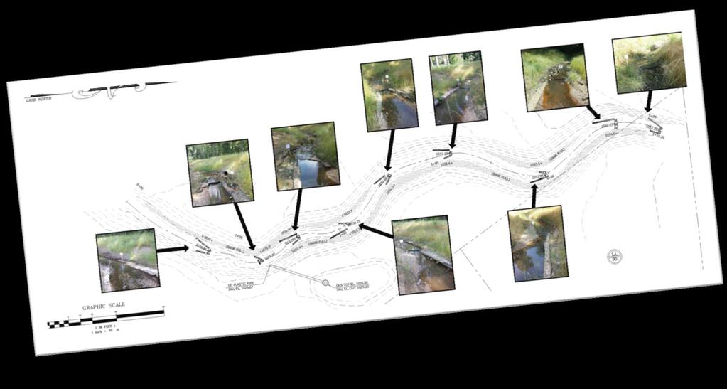
12 Pre-construction Monitoring Visual inspection Establish GPS-based photo benchmarks Physical habitat assessment Macroinvertebrate sampling in accordance with GaDNR standard operating procedure (Suboptimal Upper Reach 103 and Marginal Lower Reach 85) Pebble count modified Wohlman Pebble Count TSS Loading estimation assess exposed banks Benthic Macroinvertebrate Collection and Assessment (Marginal to suboptimal) Water Quality Sampling (July-Oct 2012) during storm events for E.Coli, BOD, TN, TP, TSS, DO, ph 12
13 Permits and Regulatory Ga EPD Stream buffer variance US Army Corps Nationwide Permit 27 (2012) US Army Corps Nationwide Permit 3, 16, 27, 43 (2014) o NWP 3 Maintenance o NWP 16 Return Water From Upland Contained Disposal Areas o NWP 27 Aquatic Habitat Restoration, Establishment, and Enhancement Activities o NWP 43 Stormwater Management Facilities 13

, cross")


14 Proposed Design Features - Stream In-stream structures log j-hook (8), cross vane (1) Bankfull benches Enhancement of riparian buffer Removing invasive species Three zones of planting 14


15 Proposed Design Features - Stream


16 Phase 1 Construction October 2013 March 2014 Pump around active construction phases 16


17 Proposed Design Features - Bioretention Surface area 2,800 SF Treats runoff from 4.4 ac. Constructed - Dec
 0.45 0.45 0 (1.14*) 0.51 Total surface area (Ac.) 0.45 0.65 0 (1.14*) 0.77 NW Depth (ft.) 2 4.75 0 4.")
18 Proposed Design Features - Ponds East and West pond excavation West Pond dam/berm construction Cascade outfall structure East Pond West Pond Existing Proposed Existing Proposed Wet Surface area (Ac.) (1.14*) 0.51 Total surface area (Ac.) (1.14*) 0.77 NW Depth (ft.) Wet volume (CF) 39,000 59, ,000 Total volume (CF) 39, , , culvert between ponds Triple culvert replacement Littoral zone planting 18


19 Proposed Design Features - Ponds 19


20 Proposed Design Features - Ponds 20

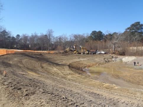


21 Phase 2 Construction Oct 2014-June


22 Phase 2 Construction 22


23 Phase 2 Construction 04/ / / / /


24 Project Benefits Additional flood storage capacity Reduce year peak flows Stream restoration will provide floodplain connectivity Improve water quality and habitat for Wildcat Creek TSS load reduction at project outlet > 450,000 lb/yr 24
25 Acknowledgements Gwinnett County Department of Water Resources Gwinnett County Parks and Recreation Cornerstone Golf Partners Georgia Development Partners Golder Associates Inc. Columbia Engineering & Services, Inc. 25