BEFORE THE COMMISSIONER APPOINTED BY THE CENTRAL OTAGO DISTRICT COUNCIL
|
|
|
- Clemence Walters
- 5 years ago
- Views:
Transcription
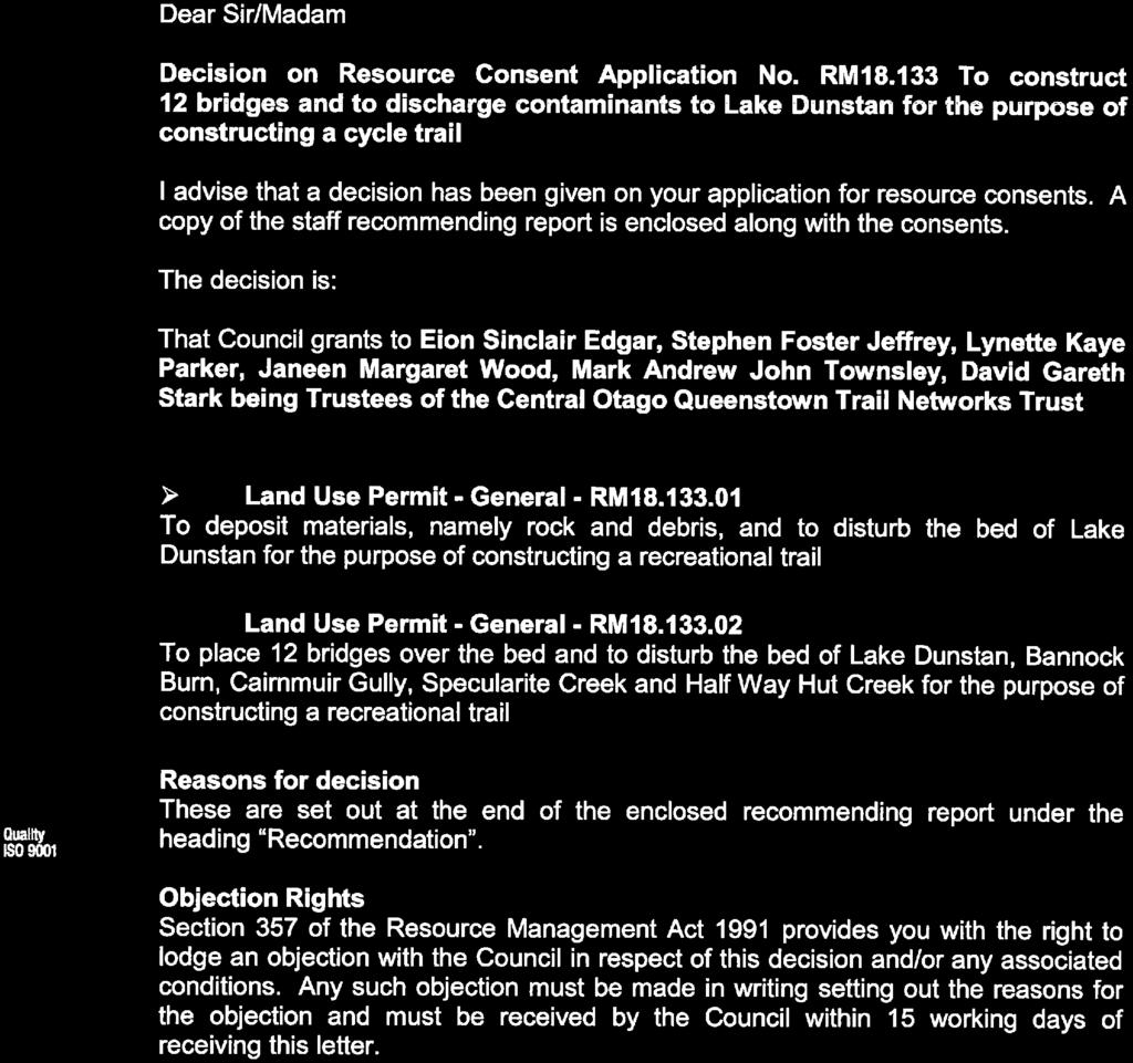
1 1 BEFORE THE COMMISSIONER APPOINTED BY THE CENTRAL OTAGO DISTRICT COUNCIL IN THE MATTER AND IN THE MATTER of the Resource Management Act 1991 of an application for resource consent under section 88 of the RMA for earthworks and structures associated with the construction of a walking and cycling trail. Central Otago Queenstown Trail Network Trust RC STATEMENT OF EVIDENCE OF SCOTT SNEDDON EDGAR 19 November 2018
2 2 1.0 QUALIFICATIONS AND EXPERIENCE 1.1 My name is Scott Sneddon Edgar. I am a Resource Management Planner and hold a Bachelor of Arts Degree (Honours) in Town and Country Planning from Strathclyde University in Glasgow, Scotland. I am an Associate Member of the New Zealand Planning Institute. 1.2 I have recently begun operating as an independent planning consultant, having been employed by Southern Land Limited, a Wanaka based survey and planning consultancy, since October During my time at Southern Land I have been involved principally with the preparation of resource consent applications and the presentation of planning evidence at Council hearings. 1.3 Prior to relocating to New Zealand in 2005 I worked as a development control planner with various Scottish local authorities in both rural and urban regions. 1.4 Upon my arrival in New Zealand I was employed as a resource consents planner in the Wanaka office of Civic Corporation Limited before taking my previous position with Southern Land Limited and more recently setting up Edgar Planning Limited. I have a total of 19 years planning experience, 13 of which have been gained in New Zealand. 2.0 CODE OF CONDUCT 2.1 I confirm that I have read the Code of Conduct for Expert Witnesses contained in the Environment Court of New Zealand Practice Note 2014 and I agree to comply with it. In that regard I confirm that this evidence is written within my expertise, except where I state that I am relying on the evidence of another person. I have not omitted to consider material facts known to me that might alter or detract from the opinions expressed. 3.0 SCOPE OF EVIDENCE 3.1 The purpose of this evidence is to inform the Commission on the resource management issues associated with the application by the Central Otago Queenstown Trail Network Trust to undertake earthworks and construct retaining structures and bridges associated with the formation, operation and maintenance of a walking and cycling trail along the true right side of Lake Dunstan between Bannockburn Inlet and the Clyde Dam.
3 3 3.2 Prior to preparing this evidence I visited the application site and its surrounds with Mr. Dennis on 2 nd November I have reviewed the application, its associated reports and further information provided. I have also reviewed the submissions that have been received and the reports prepared by Council s officers. In addition I have had the assistance of the evidence prepared by Ms. Janeen Wood (for the applicant), Mr. Tim Dennis (project manager and trail designer), Mr. Phillip Blakely (landscape architect) and Mr. Jeff Bryant (geotechnical engineer). 3.3 My evidence will address the following matters: 4.0 The Application Site and Locality 5.0 The Proposed Development 6.0 District Plan Context and Consents Required 7.0 Section 42A Report 8.0 Bundling of Activities 9.0 Assessment of Environmental Effects 10.0 Recommended Conditions 11.0 Assessment of the Relevant Provisions of the Operative District Plan 12.0 Assessment of the Relevant Provisions of the Operative and Proposed Regional Policy Statements for Otago 13.0 Section 104 Assessment 14.0 Conclusion 4.0 The Application Site and Locality 4.1 The application site and its locality have been described in detail in the resource consent application. Having visited the site I consider that description to be accurate and rely on it for the purposes of this evidence. 5.0 The Proposed Development 5.1 The details of the proposed development have been discussed at length in the resource consent application and the subsequent further information. I will not repeat the detailed description of the proposed development in this evidence but
4 4 will summarise it and discuss amendments to the proposal and points of clarification as follows: The proposal involves undertaking earthworks and the construction of retaining walls and bridges associated with the formation, operation and maintenance of a 31.4km walking and cycling trail along the true right side of Lake Dunstan between the Bannock Burn Inlet and the Clyde Dam; Approximately 21.7km of the trail is located within the Water Surface and Margin Resource Area and can be constructed as a permitted activity; Works within the Water Surface and Margin Resource Area for which resource consent is required are limited to the construction of 490m of retaining structures (split over four locations) as the trail rounds the Bannockburn Inlet; Approximately 9.7km of the trail is located within parts of the Rural Resource Area with Outstanding Natural Landscape and Area of Significant Natural Value overlays; The works within the Rural Resource Area that require consent comprise the cutting of new tracks (including earthworks within 10m of a waterbody), earthworks, the construction of an 18m bridge at 10 Mile Creek and an 85m bridge at Specularite Creek and the placement of toilets at Cairnmuir Gully and Halfway Hut Creek. 5.2 In conjunction with Mr. Blakely s assessment of the cumulative landscape effects of the proposed works (which includes the effects of the sections of trail that can be constructed as a permitted activity) the Trust has resolved to amend the trail design in certain sections to mitigate adverse cumulative effects. Those mitigation works are outlined in the Earthworks Mitigation Plan provided as part of the further information and include the following: The reduction of the finished trail widths in visually sensitive locations; Stripping, stockpiling and re-spreading topsoil and organic material; Selective replanting/revegetation and rock placement to soften the appearance of the trail; and The use of excess cut material to fill in and rehabilitate existing tracks where possible.
5 5 5.3 While these mitigatory works relate to the permitted sections of trail within the WSMRA and are therefore outside of Council s control in terms of conditions that could be applied the applicant has offered these works to be conditions on an Augier basis. 6.0 District Plan Context and Consents Required 6.1 Before embarking on an assessment of the consents required and the effects of the proposed development it is important to consider the District Plan context. I will discuss the Objectives and Policies in more detail later in this evidence but for the purpose of establishing the District Plan context I will briefly discuss the resource management issues, objectives and policies set out in the Operative District Plan as they specifically relate to the proposed development. 6.2 Section 2 of the Central Otago District Plan describes the resources and significant resource management issues of the District and identifies the following significant issues of particular relevance to the proposal: Significant Issue Outstanding Natural Landscapes and Outstanding Natural Features The District contains a number of outstanding natural landscapes and outstanding natural features that require identification and protection from inappropriate subdivision, use and development. In determining what is inappropriate subdivision, use and development in these landscapes it must be recognised that these landscapes are often utilised by people and communities to provide for their social, economic and cultural wellbeing. 1 and Significant Issue Access to Lakes and Rivers Public access to and along the margins of the District s lakes and rivers is important to existing and future residents and visitors to the District. Riparian access is not always available for public health and safety or operational reasons and is capable of being obstructed by development adjacent to lakes and rivers. 2 and Significant Issue Increasing Visitor Numbers 1 Central Otago District Plan, Page 2:9 2 Central Otago District Plan, Page 2:28
6 6 The increase in visitor numbers to the District provides opportunities for economic and social benefits that are to be recognised in the management of the District s natural and physical resources These resource management issues, together with the other issues identified in Section 2, inform the application of the District Plan s zoning and the objectives, policies and rules applicable within those zones. 6.4 Section 4 : Rural Resource Area reiterates the significant issues relating to ONLs, access to lakes and rivers and increasing visitor numbers and includes objectives and policies that seek to recognise the community s need to provide for their social, economic and cultural wellbeing (Objective 4.3.1), protect the District s ONLs from inappropriate use and development (Objective and Policy 4.4.1) and to maintain and enhance the quality of the District s recreation resources and public access to those resources (Objective and Policy ). Overall the objectives and policies of Section 4 take a balanced approach to the protection of the District s landscape resource while providing for the community s social, cultural and economic wellbeing, promoting public access to significant features and providing recreational opportunities. 6.5 Section 5 : Water Surface and Margin Resource Area also reiterates the significant issue relating to access to lakes and rivers while the significant issue relating to ONLs is absent. This is carried through to the Section 5 objectives and policies which focus on (among other things) the maintenance and enhancement of amenity values, recreational values, public access and safety and efficiency of navigation. 6.6 While a number of policies contained in Section 4 apply to the Water Surface and Margin Resource Area 4 none of those policies relate to ONLs and the Water Surface and Margin Resource Area is excluded from the ONL on the planning maps. The primary purpose of the Water Surface and Margin Resource Area is therefore the provision and management of recreation, public access and the ongoing operation of existing hydro electric power stations. 6.7 Also of some relevance, albeit indirectly, to the District Plan context are objectives and policies contained in Section 16 : Subdivision which relate to public access. Objective seeks to ensure that subdivision maintains and enhances (where appropriate) public access to and along the margins of the District s lakes and 3 Central Otago District Plan, Page 2:44 4 See Other Policies Central Otago District Plan, Page 5:7
7 7 rivers, public open space, sites of heritage and cultural values and cultural importance to Kai Tahu ki Otago. 6.8 Policy relates to Esplanade Provision and seeks to ensure (where appropriate) that subdivision of land recognises and provides for the purposes set out in s229 of the Act by requiring the provision of an esplanade reserve of strip on subdivision. 6.9 In its explanation under Policy the plan states: The maintenance and enhancement of public access to and along the margins of rivers of lakes is also a matter of national importance by virtue of section 6 of the Act. Subdivision, which often facilitates more intensive development, has the potential to compromise public access. Where this is a possibility, consent will only be granted subject to appropriate provisions being made for access I do not know whether an esplanade reserve was taken at the time the subdivision on Cornish Point Road was consented however I consider that Policy and its explanation makes Council s position clear in terms of the interests of private individuals verses the matters of national importance set out in section 6 of the Act The proposed trail alignment is located within the Water Surface and Margin Resource Area and the Rural Resource Area, dipping in and out of each resource area as topography and required trail grades dictate. The proposed retaining structures within the WSMRA around Bannockburn Inlet require the following resource consent: A discretionary activity resource consent pursuant to Rule 5.7.3(a) as the proposal breaches Standard 5.7.4A Structures (the proposed retaining not being covered by the exemptions to the standard) 6.12 Aside from the proposed retaining structures the construction, use and maintenance of the trail within the WSMRA is a permitted activity. In addition it should be noted that, as Mr. Dennis has explained 5, the trail around the Bannockburn Inlet could be constructed without the proposed retaining walls but they have been included in order to reduce the extent of batter slopes and erosion. 5 Statement of Evidence, Paragraph 6.6
8 Where the trail crosses into the Rural Resource Area in areas subject to the Outstanding Natural Landscape and Area of Significant Natural Value overlays I consider the following resource consents are required: A discretionary (restricted) activity resource consent pursuant to Rule 4.7.3(vi) as proposal breaches Standard I. Riparian Margins as the proposal involves earthworks in excess of 20m 3 within 10m of waterbodies (being various small creeks) A discretionary activity resource consent pursuant to Rule 4.7.4(i) as the proposal breaches Standard L. Outstanding Natural Landscapes, Outstanding Natural Features and Land in the Upper Manorburn/Lake Onslow Landscape Management Area as it involves the erection of structures (2 x bridges and 2 x toilets), cutting of new tracks and excavation of more than 20m 3 and disturbance of land greater than 50m 2 per hectare I note that the proposed toilets (which fall under the definition of buildings in the District Plan) were not included in the original application, it being the applicant s preference to determine the required position of such facilities once the trail is constructed and user needs are assessed. The proposed toilet positions were however identified at the request of Council as part of the further information provided. While the toilets would be a permitted activity in the WSMRA their positions were selected to minimise visibility and landscape effects with the least visible positions being in the Rural Resource Area and requiring a discretionary activity resource consent as outlined above While the proposed toilets increase the number of buildings for which consent is sought I do not consider that they increase the scope of the development to the point where members of the public who did not lodge a submission would have done so had the toilets been included in the application as notified I consider however that, should it be determined that the proposed toilets are outside the scope of the application as notified, that the applicant could revert to their preferred option of identifying toilet positions on completion of trail construction and either seek additional consents (if located in the Rural Resource Area) or construct the toilets as a permitted activity (in the WSMRA) Overall I consider the proposed development to be a discretionary activity.
9 9 7.0 Section 42A Report 7.1 A Section 42A report has been prepared by Mr. Oli Monthule-McIntosh in which he recommends that the application is granted subject to conditions. 7.2 Mr. Monthule-McIntosh s s42a report is accompanied by a peer review of Mr. Bryant s assessments prepared by WSP Opus. 7.3 I have read the s42a and supporting peer review. While I agree with the majority of Mr. Monthule-McIntosh s assessment and recommendation there are a number of points on which I do not entirely agree and will discuss these in the following sections of this evidence. 8.0 Bundling of Activities 8.1 With regard to the matter of bundling I consider that the Southpark approach, as outlined in Mr. Page s letter to Council dated 17 September 2018, should apply to the assessment and consideration of the proposed development and that aside from additive or cumulative effects the effects of the permitted elements of the trail are not relevant. 8.2 While I agree with Mr. Monthule-McIntosh that regardless of whether the Locke or Southpark principle is applied, when the permitted baseline is taken into consideration, the same conclusion with regard to the appropriateness of the proposal may be arrived at I do not agree that the distinction between the two approaches is entirely academic as there are jurisdictional implications relating to whether conditions can be imposed on the permitted sections of trail. It is my opinion that conditions cannot imposed on the permitted sections of trail however I note that the applicant has offered conditions on an Augier basis that address landscape and ecological effects related to the permitted sections. 9.0 Assessment of Environmental Effects 9.1 I have reviewed the assessment of effects contained in the consent application and the additional information provided post notification. I generally agree with and adopt the assessment contained in the consent application. In the following assessment of effects I will address matters raised in submissions and the further information provided post notification. For ease of comparison I will generally follow the same order of headings set out in Mr. Monthule-McIntosh s assessment of effects which in turn generally follows the headings set out in the application.
10 10 Permitted Baseline 9.2 Pursuant to Section 104(2) of the Act, when considering the actual and potential effects of an application for resource consent, a consent authority may disregard an adverse effect of an activity if the plan permits an activity with that effect (the permitted baseline). 9.3 The permitted baseline includes any lawful activities occurring on the site, any permitted hypothetical (although not fanciful) activities and any activities authorised by unimplemented resource consents. 9.4 In this case I consider the permitted baseline includes the following: Removal of vegetation and earthworks associated with the formation of walkways within the WSMRA; Construction of bridges and installation of culverts within the WSMRA; Farming activities within the WSMRA and RuRA; Erection of warning and information signage up to 3m 2 in area, waste receptacles and public toilets within the WSMRA; Formation of tracks in the RuRA except where identified as an ONL or Area of Significant Natural Value; Earthworks associated with the maintenance of existing roads and tracks within the RuRA and ONL; Recreational activities and public access within the WSMRA and RuRA. 9.5 In terms of the permitted sections of trail within the WSMRA I consider that it is not fanciful to expect that they may be constructed at some point irrespective of the outcome of this consent application. The section of trail around Bannockburn Inlet and Cornish Point would offer an attractive and popular ride in its own right and there is support from central government for the existing Great Rides to be linked. The Existing Environment 9.6 The existing environment is of relevance to the consideration of the proposed development and comprises existing and/or consented development on the application site, The existing environment includes the following:
11 11 The construction of bridges/structures consented under Otago Regional Council resource consent RM a copy of which is attached as Appendix A to this evidence; The existing 4wd tracks within the RuRA and ONL; The existing Cairnmuir Slide slope stabilisation works and associated infrastructure (drainage channels, tunnels, electrical and control structures, pipes and power lines); Gold mining tracks, water races and huts; White painted survey benchmarks; Electricity lines and pylons; The Clyde Dam and Lake Dunstan itself. 9.7 In addition I agree with and adopt the additional points set out at section 6.1 of Mr. Monthule-McIntosh s report. The Receiving Environment 9.8 In addition to the permitted baseline and the existing environment the receiving environment (comprising existing and consented development in the vicinity of the application site) requires consideration. The receiving environment includes the following: State Highway 8 which conveys in excess of 5,000 vehicles per day (including over 350 heavy vehicles); Farming activities; Power lines, pylons, tunnels, gravel buttresses, infrastructure, buildings etc. associated with the Clyde Dam and slope stabilisation works; Boat ramps and rest areas. 9.9 Again I agree with and adopt the additional points set out at section 6.2 of Mr. Monthule-McIntosh s report.
12 The permitted baseline and existing and receiving environments provide for and include a significant degree of activity and modification of the landscape and I consider that it is within this context that the actual and potential effects of the proposed development should be considered. Earthworks and Geotechnical Issues 9.11 Based on the assessments of Mr. Bryant and the peer review of WSP Opus I agree with Mr. Monthule-McIntosh that the proposed earthworks will result in no more than minor adverse effects on slope stability and water quality In terms of the rock fall hazard I adopt the opinion of Mr. Bryant, it being based on site specific investigations and, what I understand to be, an industry standard qualitative risk assessment On that basis I consider that rock scaling that will be undertaken as part of the trail construction will assist in mitigating the rock fall hazard and the proposed signage will alert trail users to the presence of the hazard and allow them to determine for themselves whether the risk is tolerable. I understand from Mr. Dennis evidence that this approach is consistent with other cycle trails in the region and as Mr. Bryant has pointed out the rock fall risk is comparable with other recreational activities routinely enjoyed by the public (i.e. whitewater rafting, rock climbing, tramping and road cycling) The management of significant risks from natural hazards is identified as a matter of national importance under s6(h) of the Act and, under s31(1)(b)(i), territorial authorities are to control the actual and potential effects of the use and development of land for the avoidance or mitigation of natural hazards. The means by which territorial authorities can control such effects is through the establishment, implementation and review of objectives, policies and methods as set out under s31(1)(a). While the WSMRA includes policies 6 which seek to ensure that the safety of recreational users is not compromised and that activities make provision for public access except where a restriction is necessary to protect the safety of the public, the construction and recreational use of the trail is a permitted activity. I therefore consider that, in the formulation of the District Plan s objectives, policies and rules, the risks associated with recreational activities and public access (including potential risks posed by natural hazards) are acknowledged and accepted and that the risks that the objectives, policies and rules seek to control are the risks posed by activities, structures and buildings 6 Policies and 5.4.6
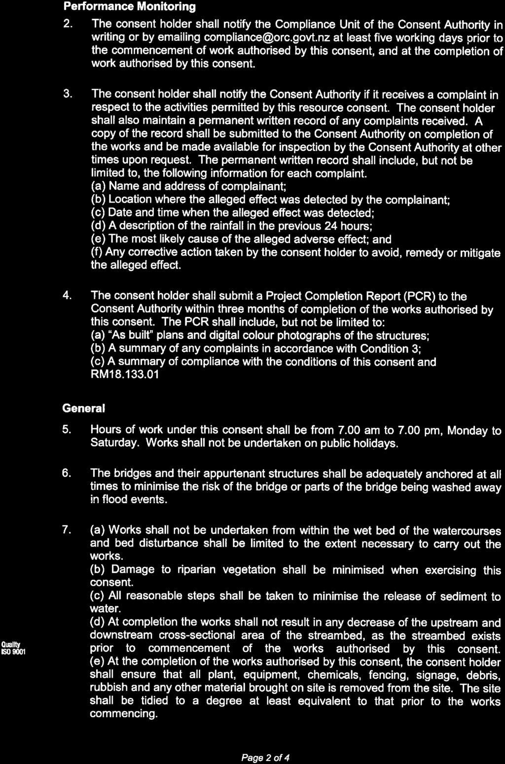
13 13 that are not provided for as permitted activities seeking to locate within the WSMRA I consider that the proposed trail is similar to any backcountry trail the use of which includes elements of risk such as river crossings, exposed sections and remoteness. I consider the rock scaling works and signage will appropriately manage the risks associated with the construction and use of the trail relative to the inherent risks associated with undertaking recreational activities in the outdoors. Native Flora and Fauna 9.16 Having reviewed the Botanical Assessment carried out by Ms. Wardle and the advice of the Department of Conservation I agree with Mr. Monthule-McIntosh that, subject to the inclusion of Ms. Wardle s recommendations as conditions of consent (as offered by the applicant), the proposed works will result in adverse effects on native flora and fauna that are no more than minor. Visual Effects 9.17 I adopt and rely on the opinions of Mr. Blakely with regard to the landscape and visual effects of the proposed trail and on that basis I consider that overall, subject to the implementation of the earthworks mitigation plan put forward by the applicant, the proposed trail will result in moderate to low adverse effects on the landscape. Where sections of trail may result in significant landscape and visual effects in the short to medium term these effects will reduce to low over time and I consider that it is not unreasonable to expect that, in terms of landscape, it will take time for mitigation to take effect. Overall I consider that, in the context of the permitted baseline and the existing and receiving environments the adverse landscape and visual effects of the proposed trail will not be inappropriate In terms of Options 1 and 2 at Halfway Hut Creek Mr. Blakely finds that Option 1 will result in significant landscape and visual effects reducing to low over time while Option 2 will result in moderate effects in this regard. Given that other factors such as cost of construction will weigh in the decision on whether Option 1 or 2 is pursued and that neither option will result in significant adverse effects in the long term I do not agree with Mr. Monthule-McIntosh that Option 2 is preferable. I consider that both options are appropriate.
14 14 Amenity Effects 9.19 I agree with Mr. Monthule-McIntosh in his opinion on the merits of the opposing submissions relating to amenity effects on the adjoining residential properties at Cornish Point. Public access to the margins of lakes and rivers is a matter of national importance under s6 of the Act and the District Plan specifically provides for it at the time of subdivision through esplanade provisions. Further I consider, for the reasons already set out in this evidence, that the adverse effects of the elements of the trail for which consent is not required cannot be considered (with the exception of cumulative effects). That being said, regardless of whether there is jurisdiction to consider such effects, it is my opinion that when the permitted baseline is taken into consideration the trail alignment around Cornish Point will result in no greater effect than could otherwise occur as a permitted activity. Cultural and Heritage Effects 9.20 Based on the assessment of Kopuwai Consulting and the subsequent amendment to the submissions of Aukaha and Te Ao Marama Inc (from opposing to neutral) I agree with Mr. Monthule-McIntosh that, subject to the implementation of the recommendations contained in the Kopuwai report, the proposed trail will result in net positive effects in terms of cultural and heritage values. Positive Effects 9.21 The economic benefits outlined in the consent application and in the evidence of Ms. Wood demonstrate that the proposed trail will result in significant positive economic effects. Further I consider that the proposed trail is likely to result in positive effects on the physical and social wellbeing of the community. Summary 9.22 Overall I consider that the adverse effects of the proposed trail can be mitigated such that they will not be inappropriate. In addition I consider that the proposal will result in significant positive effects and will contribute to the community s physical, social and cultural wellbeing Recommended Conditions 10.1 Having reviewed the recommended conditions of consent set out in Section 9 of Mr. Monthule-McIntosh s report I consider them to be generally appropriate subject to the following amendments.
15 For the reasons set out at paragraph 9.18 of this evidence I consider that Condition 1 should be amended to remove reference to Option 2 at Halfway Hut Creek. Condition 1 should in my opinion read: 1. The walking and cycling trail shall be constructed in general accordance with plans attached as Appendix 1 to this decision I consider that there is some uncertainty in Condition 3 as to whether the prohibition of works on weekends or public holidays applies to the sections of trail adjoining the Residential Resource Area (1) at Cornish Point or the trail as a whole. Given the remote location of much of the trail and the fact that recreational users of Lake Dunstan could choose to use a different parts of the lake if noise or dust effects were bothersome I consider that it would be unnecessarily restrictive to apply the prohibition of works on weekends and public holidays to the entirety of the trail. I therefore consider that recommended Condition 3 should be reworded as follows: 2. On land immediately adjoining the Residential Resource Area (1) at Cornish Point construction works (including vegetation clearance and earthworks) shall be limited to the hours of 7:00am 6:00pm Monday to Friday with no works being undertaken on weekends or public holidays Based on the evidence of Mr. Bryant and Mr. Dennis I consider that recommended conditions 5 to 8 impose an unreasonable burden on the applicant. Mr. Dennis has advised that sections of trail where rockfall hazards may be present are at the following chainages: 9,800 to 10,100 Hartleys Bluff to Reilly s Bluff 11,200 to 11,400 below the north western end of the area of slippage/subsidence 12,100 to 12,400 Pick Axe Bluff to Cairnmuir Gully 19,100 to 20,000 Mt. Jackson Creek towards Halfway Hut Creek 10.5 The above sections of trail are located entirely within the WSMRA and can be constructed as a permitted activity. I therefore consider there to be jurisdictional issues relating to the ability to impose conditions on the permitted sections of trail. I note that the Roxburgh Gorge Trail was subject to similar natural hazards and that Commissioner Nugent did not consider it necessary to impose conditions
16 16 relating to the management or mitigation of those hazards. I consider that it is appropriate for the same approach to be taken in this application I consider the remaining recommended conditions to be appropriate Assessment of the Relevant Provisions of the Operative District Plan 11.1 The objectives and policies of the District Plan that are of particular relevance to the consideration of the proposal are contained in Section 4 : Rural Resource Area and Section 5 : Water Surface and Margin Resource Area and are as follows: Objective - Needs of the District s People and Communities To recognise that communities need to provide for their social, economic and cultural wellbeing, and for their health and safety at the same time as ensuring environmental quality is maintained and enhanced I consider that the proposed trail is consistent with Objective Objective Outstanding Natural Landscapes and Outstanding Natural Features, and Land in the Upper Manorburn/Lake Onslow Landscape Management Area To protect the Districts outstanding natural landscapes and outstanding natural features, and land in the Upper Manorburn/Lake Onslow Landscape Management Area (including landforms) from the adverse effects of inappropriate subdivision, use and development I consider that the adverse effects of the proposed trail can be mitigated to an appropriate level and given that the resource management issue that the objective seeks to address acknowledges that people and communities often use ONLs to provide for their social, economic and cultural wellbeing (which is the case in this instance) I consider that the proposed trail does not constitute the inappropriate use and development of the ONL and consequently I consider that the proposal is consistent with Objective Objective - Landscape and Amenity Values To maintain and where practicable enhance rural amenity values created by the open space, landscape, natural character and built environment values of the District s rural environment, and to maintain the open natural character of the hills and ranges.
17 Based on the assessment and evidence of Mr. Blakely I consider that the proposed trail is generally consistent with Objective Objective - Recreation Resources To maintain and enhance the quality of the District s recreation resources and public access to those resources I consider that the proposed trail will provide a valuable addition to the District s recreation resource and provide public access to parts of the District not readily accessible at present. I therefore consider that the proposed trail is consistent with and gives effect to Objective Objective - Water Resources To maintain and enhance the quality of the District s water resources by avoiding, remedying or mitigating the adverse effects of land use activities adjacent to water bodies I consider that the proposed works will not result in significant adverse effects on the quality of the District s water resources and consequently I consider that the proposal is consistent with Objective Objective - Margins of Water bodies To preserve the natural character of the District s water bodies and their margins It is my opinion that the proposed trail will not compromise the natural character of Lake Dunstan and its margins to an extent that is not anticipated and provided for in the District Plan and therefore I consider that the proposal is generally consistent with Objective Objective - Significant Indigenous Vegetation and Habitats of Indigenous Fauna To recognise and provide for the protection of areas of significant indigenous vegetation and significant habitats of indigenous fauna Based on the assessment and recommendations of Ms. Wardle and the advice of the Department of Conservation I consider that the proposed trail will be constructed and aligned so as to protect areas of significant vegetation and significant habitats of indigenous fauna. I therefore consider that the proposed trail is consistent with Objective
18 Policy - Outstanding Natural Landscapes and Outstanding Natural Features and Land in the Upper Manorburn/Lake Onslow Landscape Management Area To recognise the District s outstanding natural landscapes and outstanding natural features and land in the Upper Manorburn/Lake Onslow Landscape Management Area which: (a) (b) (c) (d) (e) (f) Are unique to the district, region or New Zealand; or Are representative of a particular landform or land cover occurring in the Central Otago District or of the collective characteristics and features which give the District it s particular character; or Represent areas of cultural or historic significance in the district, region or New Zealand; or Contain visually or scientifically outstanding geological features; or Have characteristics of cultural, historical and spiritual value that are significant to Kai Tahu ki Otago; Have high natural character values and high landscape quality that can be distinguished from the general landscapes of the Central Otago District and provide protection for them from inappropriate subdivision, use and development I consider that the adverse effects of the proposed trail on the ONL can be appropriately mitigated and that, taking into consideration (as directed in the Plan) the fact that the proposed works provide for and will enhance the social, economic and cultural wellbeing of the community, the proposal does not represent the inappropriate use and development of the ONL. I therefore consider that the proposed is consistent with Policy Policy Landscape and Amenity Values To manage the effects of land use activities and subdivision to ensure that adverse effects on the open space, landscape, natural character and amenity values of the rural environment are avoided, remedied or mitigated through:
19 19 (a) (b) (c) (d) (e) (f) (g) The design and location of structures and works, particularly in respect of the open natural character of hills and ranges, skylines, prominent places and natural features, Development which is compatible with the surrounding environment including the amenity values of adjoining properties, The ability to adequately dispose of effluent on site, Controlling the generation of noise in back country areas, The location of tree planting, particularly in respect of landscape values, natural features and ecological values, Controlling the spread of wilding trees. Encouraging the location and design of buildings to maintain the open natural character of hills and ranges without compromising the landscape and amenity values of prominent hillsides and terraces I consider that the proposed works have been designed and located in order to minimise adverse effects on the landscape and amenity values of the Rural Resource Area wherever possible. I consider the proposed trail to be compatible with the surrounding environment including the amenity values of adjoining properties and will not result in a significant increase in noise in back country areas aside from temporary construction noise. In addition the proposed revegetation associated with the construction of the trail will be carefully undertaken to ensure that landscape and ecological values are maintained and enhanced and the proposed buildings (i.e. toilets) have been positioned in order to maintain the open natural character of the ONL and avoiding adverse effects on the landscape and amenity values of prominent hillsides and terraces. I therefore consider that the proposed development is consistent with Policy Policy - Riparian Margins 7 To manage the effects of the use, development or protection of land within riparian margins of water bodies (including wetlands) to ensure that the natural character and amenity of water bodies and their margins are preserved, by, as far as practicable: (a) (b) Maintaining bank stability, Protecting, and where appropriate, enhancing riparian and instream habitat quality, 7 Also applies to the Water Surface and Margin Resource Area
20 20 (c) (d) (e) (f) (g) Maintaining and enhancing riparian vegetation, Maintaining water quality, Maintaining and enhancing public access to and along the lakes and rivers, Reducing the incidence and severity of flooding where this is achievable, and Maintaining and enhancing the safety and efficiency of navigation on the adjacent water body where this is relevant while recognising that some activities need to locate within riparian margins to operate efficiently. Note: In matters relating to riparian vegetation Policies and of the Otago Regional Council s Regional Plan : Water are relevant Drawing on the assessments, advice and evidence of Mr. Bryant, Ms. Wardle, the Department of Conservation and Mr. Dennis I consider that the proposed works will not compromise bank stability or result in adverse effects on riparian, instream habitat and water quality. In addition I consider that the proposed works will appropriately maintain and enhance riparian vegetation and will provide for public access along the margins of Lake Dunstan and its associated side creeks. I therefore consider that the proposed development is consistent with and gives effect to Policy Policy Significant Indigenous Vegetation, Wetlands and Wildlife 8 To protect areas of: (a) (b) (c) (d) (e) Significant indigenous vegetation, Significant habitats of indigenous fauna, Significant wetlands, Indigenous vegetation or habitats that support a significant indigenous fresh water fishery, and Habitats of statutorily managed sports fish and game. from the adverse effects of land use activities and subdivision and to promote and encourage, where practicable, the retention, enhancement and reinstatement of indigenous ecosystems within the District. 8 Also applies to the Water Surface and Margin Resource Area
21 Based on the assessment of Ms. Wardle and the advice of the Department of Conservation I consider that areas of significant indigenous vegetation and habitats of indigenous fauna will be appropriately protected. I therefore consider that the proposed development is consistent with Policy Policy - Adverse Effects on the Amenity Values of Neighbouring Properties. To ensure that the effects associated with some activities including (but not limited to): (a) (b) (c) (d) (e) (f) Noise (including noise associated with traffic generation, night time operations), and vibration, The generation of a high level of traffic, in particular heavy vehicles, Glare, particularly from building finish, A reduction in visual amenity due to excessive signage and the storage of goods or waste products on the site, The generation of odour, dusts, wastes and hazardous substances, and The use and/or storage of hazardous goods or substances do not significantly adversely affect the amenity values and privacy of neighbouring properties or the safe and efficient operation of the roading network. do not significantly adversely affect the amenity values and privacy of neighbouring properties or the safe and efficient operation of the roading network I consider that the construction and use of the proposed trail within the Rural Resource Area (to which Policy applies) will not result in adverse effects on the amenity values and privacy of neighbouring properties or the safe and efficient operation of the District s roading network. I therefore consider that the proposed development is consistent with Policy Policy - Public Access to Significant Features 9 To promote the provision of public access opportunities to the Districts significant natural and physical land features including areas of value for recreational purposes. 9 Also applies to the Water Surface and Margin Resource Area
22 It is my opinion that the proposed development gives effect to Policy Policy - Back Country Amenity Values To ensure that activities avoid, remedy or mitigate adverse effects on the open space, landscape, historic, natural character, natural quiet and amenity values of the quality and range of recreational opportunities available in, the District s back country and/or remote areas I consider that the adverse effects of the proposed trail works will be appropriately avoided, remedied or mitigated such that open space, landscape, historic, natural character and amenity values will not be compromised. While construction works will add an element of noise and activity not otherwise present I consider that such effects will be temporary and are balanced by the increased public access to back country areas that the trail will provide. I therefore consider that the proposed development is consistent with Policy Policy - Conflict between Recreation Activities To recognise and avoid, remedy or mitigate the potential conflict between different types of recreation activities that occur within the District, whilst encouraging multiple use of public open space and recreation areas wherever this is possible and practicable No potential conflicts between recreation activities have been identified through the notification and consideration of the proposed development however I consider that recommended Condition 9d., which requires the installation of signage prohibiting camping, fires, firearms or motorised transport will appropriately avoid any likely conflict. I therefore consider that the proposed development is consistent with Policy Section 5 : Water Surface and Margin Resource Area Objective Amenity Values, Environmental Quality and Natural Character To maintain and enhance the amenity values and environmental quality, and to preserve the natural character of the District s lakes and rivers and their margins I consider that the retaining structures around the Bannockburn Inlet, being the only works within the WSMRA that require consent, will appropriately maintain
23 23 and enhance the natural character of the margins of Lake Dunstan in that they are proposed in order to minimise cut and fill batters and erosion. I therefore consider that the proposed works are consistent with and give effect to Objective Objective Recreational Values To maintain, where appropriate, the recreational values of the surface and margins of the District s water bodies The proposed works will not detract from the recreational values of the surface and margins of Lake Dunstan and I consider that such values will be appropriately maintained and further enhanced as a result of the proposed trail. I therefore consider that the proposed works are consistent with Objective Objective - Public Access To maintain and enhance, where appropriate, public access, to and along the surface and margins of the District s lakes and rivers The proposed trail will significantly enhance public access to and along the margins of Lake Dunstan from Bannockburn Inlet to the Clyde Dam. I therefore consider that the proposed development is consistent with and will give effect to Objective Objective - Cultural Values To recognise and provide for Kai Tahu ki Otago s spiritual beliefs, cultural traditions and practices in the management of the surface and margins of the District s water bodies Based on the heritage assessment undertaken by Kopuwai Consulting and the subsequent amendment of the Aukaha and Te Ao Marama Inc submissions from opposition to neutral I consider that Kai Tahu ki Otago s spiritual beliefs, cultural traditions and practices have been appropriately recognised and provided for and I therefore consider that the proposed development is consistent with Objective Policy - Water Surface and Margin Activities To manage the effects of activities (including the design, location and/or operation of structures) upon the water surface and margins to ensure that:
24 24 (a) (b) (c) (d) (e) (f) (g) (h) (i) (j) (k) (l) The safe and efficient navigation of any powered or non-powered craft using the water surface is not compromised; Ecological values including significant indigenous vegetation and significant habitats of indigenous fauna and instream values of the water body are protected and where appropriate, enhanced; The protection of amenity, recreational and landscape values in or near the water body is promoted or otherwise provided for; Conflict with other resource users on the water surface and adjoining land, including the effects that noise and/or wave generation may have, are avoided, remedied or mitigated; The quality of the water within the water body is maintained and/or enhanced; The stability of the bed and bank of the water body is maintained and/or enhanced; The stability of any structure located in, on or near the water body is maintained; The severity and incidence of flooding is not exacerbated by the activity; The safe and efficient operation of the adjacent road network is maintained and enhanced; Public access (where appropriate) is provided for; The spread of undesirable aquatic plants is avoided, remedied or mitigated; and The integrity of Kai Tahu ki Otago s spiritual beliefs, cultural traditions and practices in respect of water resources is considered I consider that the retaining structures for which resource consent is required, as well as the trail generally, will not result in significant adverse effects on the matters listed in (a) to (l) under Policy I therefore consider that the proposed development is consistent with Policy Policy Recreation To recognise the importance of lakes and rivers and their margins to the existing and future recreational needs of the District s people and visitors while ensuring that adverse effects on amenity values and environmental
25 25 quality are avoided, remedied or mitigated by such activities and that the safety of the recreational users is not compromised I consider that the proposed development will make a significant contribution to the recreational opportunities for residents and visitors and that the hazards associated with the construction and use of the trail have been appropriately identified and can be reduced through the proposed rock scaling. I consider that this along with the proposed warning signage will allow trail users to make an informed decision with regards to the potential risks and that the risk associated with the use of the trail can be managed such that it is similar to that of other recreational activities undertaken in the district. I therefore consider that the proposed development is consistent with Policy Policy - Public Access To ensure activities make adequate provision for public access except where a restriction is necessary: (i) (ii) (iii) (iv) (v) To protect areas of significant indigenous vegetation and/or significant habitats of indigenous fauna; To protect Kai Tahu ki Otago s cultural values; To protect public health and safety; To provide an appropriate level of security for the continued operation of existing hydro electric power stations; or In other circumstances that justify the restriction notwithstanding the national importance of maintaining public access I consider that the proposed development will appropriately protect areas of significant indigenous vegetation and habitat and cultural values and for the reasons discussed above I consider that public access need not be restricted for the protection of public health and safety. I therefore consider that the proposed development is consistent with Policy Summary Overall I consider that the proposed development is consistent with and largely gives effect to the relevant objectives and policies of the Central Otago District Plan Assessment of the Relevant Provisions of the Operative and Proposed Regional Policy Statements for Otago
26 In addition to consideration against the provisions of the Central Otago District Plan the proposed development requires consideration against the provisions of the Operative and Proposed Regional Policy Statements for Otago Having reviewed the relevant provisions of the Operative and Proposed Regional Policy Statements for Otago I agree with Mr. Monthule-McIntosh that the proposal is consistent with those provisions Section 104 Assessment 13.1 The proposed development requires consideration under Section 104 of the Act. 104 Consideration of Applications (1) When considering an application for a resource consent and any submissions received, the consent authority must, subject to Part 2, have regard to (a) (b) (c) any actual and potential effects on the environment of allowing the activity; and any relevant provisions of a national environmental standard: other regulations: a national policy statement: a New Zealand coastal policy statement: a regional policy statement or proposed regional policy statement: a plan or proposed plan; and any other matter the consent authority considers relevant and reasonably necessary to determine the application I consider that the actual and potential effects of allowing the proposed development will not be inappropriate In addition I consider that the proposed development is consistent with the objectives and policies of the Central Otago District Plan and the Operative and Proposed Regional Policy Statements for Otago I consider that there are no other matters that should preclude the granting of consent Conclusion
27 Having carefully assessed the proposed development I consider that its actual and potential adverse effects on the environment will not be inappropriate and that it is consistent with and largely gives effect to the relevant objectives and policies of the Central Otago District Plan and Operative and Proposed Regional Policy Statements for Otago and meets the purpose of the Act I consider that, subject to the amendments outlined in paragraphs 10.2 to 10.5 of this evidence, the recommended conditions of consent set out in Mr. Monthule- McIntosh s report are appropriate. DATED 19 th November 2018 Scott Sneddon Edgar Resource Management Planner Edgar Planning Limited

28


29


30

31


32


33

34

35


36


37