Lower Sacramento / Delta North Region: CORRIDOR MANAGEMENT FRAMEWORK
|
|
|
- Bathsheba Owens
- 5 years ago
- Views:
Transcription
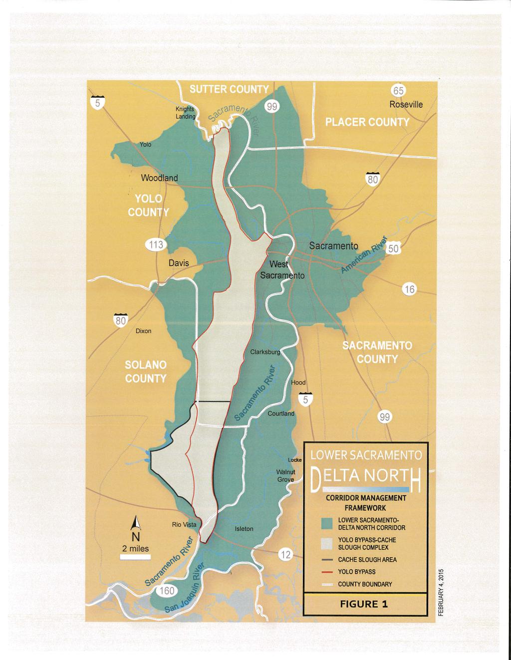
1 Lower Sacramento / Delta North Region: CORRIDOR MANAGEMENT FRAMEWORK WHAT IS THIS? A coalition of local agencies developed this (CMF) for the Lower Sacramento / Delta North Region. For the purposes of this CMF, the geographic footprint of the Lower Sacramento / Delta North Region is defined as the floodplain corridor (LS-DN Corridor) (Figure 1). The involved agencies believe that the often competing single objectives of flood risk reduction, enhanced ecosystem function, and agricultural sustainability can be integrated and achieved through a better aligned and implementation-focused partnership of federal, state, and local agencies. This CMF is founded on the concept that the LS-DN Corridor can be modified in a manner which accommodates multiple objectives through the implementation of projects and assurances that address all partners needs. Federal, state, and local interests must all be addressed in order to eliminate the organizational barriers necessary to motivate change and commit to implementation. This CMF was developed as a locally preferred approach to achieving the federal, state, and local policy objectives in the LS-DN Corridor. These policy objectives include the ability to (1) provide essential conveyance capacity and improve the resilience, reliability and adaptability of the flood system to climate change, (2) preserve agricultural land and promote a strong, sustainable agricultural economy; and, (3) conserve and improve functionality of aquatic and terrestrial species habitat consistent with the paramount flood management purpose of the system. It contains a number of projects and assurances that, if addressed together, will allow for the integration of these often competing objectives. The projects should be considered preliminary for purposes of the CMF as they are expected to evolve over time as more information is developed regarding specific project feasibility, funding availability, and local community support. The CMF also emphasizes the importance of establishing long-term collaborative and cooperative working relationships between federal, state, and local agencies that promote engagement and involvement. This CMF is intended to serve as the basis for a collaborative, constructive, and transparent partnership between federal, state, and local agencies operating in the LS-DN Corridor. It also focuses on the interrelationship that exists between the LS-DN Corridor and its central feature, the Yolo Bypass / Cache Slough Complex (YB-CS Complex) (Figure 1). The CMF recognizes the integral role of the YB-CS Complex in the performance of the flood system; and, it focuses the Lower Sacramento / Delta North Region on the YB-CS Complex as a result. While the CMF identifies a proposed approach for reconciling and advancing multiple competing objectives in the entire LS-DN Corridor, it recommends the development of a detailed Yolo Bypass / Cache Slough Complex Management Plan (Complex Management Plan) for this subregion of the CMF. This plan would tackle difficult issues within the Yolo Bypass / Cache Slough Complex 1
2 including assurances, governance, revenue, local agency funding, agricultural sustainability, and stakeholder engagement, as described in the CMF s goals and principles below. The Complex Management Plan would be developed concurrently with the development of a fully-integrated locally preferred plan, as described in further detail in Table 2 below. The locally preferred plan will identify locally-preferred projects designed to integrate habitat function, flood management, water supply, recreation, drainage infrastructure, and agricultural sustainability in the YB-CS Complex consistent with state and federal objectives. Once the Complex Management Plan is completed, with thorough stakeholder involvement, the partnership will take the form of a legally binding agreement. This agreement would include a commitment to (1) advance the projects preliminarily recommended in the CMF and in the locally preferred plan, and future projects proposed in the CMF; and, (2) provide enforceable assurances, identified by the local agencies and landowners, as critical to accommodating the integration of multiple objectives in the YB-CS Complex. HOW DID WE GET HERE? The adopted 2012 Central Valley Flood Protection Plan (CVFPP) resulted in the creation of six regional flood management planning areas in the Central Valley. These six areas were established to promote the local preparation of regional flood management plans by encouraging the flood management agencies in each region to include special districts, cities, counties, emergency responders, and other important stakeholders in a collaborative effort to resolve longstanding flood risk management issues. The intent of these regional plans is to identify and prioritize potential structural and nonstructural flood risk reduction projects while also making recommendations for improvements to levee operation and maintenance practices, levee maintenance budgeting, emergency response capabilities, and flood management governance. The Lower Sacramento / Delta North Region includes portions of Yolo, Solano, Sacramento, and Sutter Counties. A diverse collection of urban interests, small communities, agriculture-based businesses, and environmental stakeholders with historically conflicting needs related to water and land use reside within the region. Flood protection is the paramount function within the Yolo Bypass and is critically important to the region since it contains nearly 70% of the estimated annual damages associated with all floodplains protected by the State Plan of Flood Control (SPFC) facilities [CVFPP 2012]. While this fact may lead many to believe the region is largely urban and developed, its land use suggests otherwise with 66% of the land in the region currently in agriculture, 18% developed for urban or suburban use, and 16% in a native condition or used primarily for grazing [DWR 2013]. The Lower Sacramento / Delta North Region published a Final Regional Flood Management Plan (RFMP) on July 21, The report recommends 116 flood risk management projects (30 urban, 21 small community, and 65 rural) totaling over $2.0 billion. This RFMP also introduced the concept of an Integrated Water Management Plan (IWMP) for the YB-CS Complex. 2
3 Through continued collaboration with the State of California Department of Water Resources (DWR), the IWMP concept was replaced with the development of a comprehensive LS-DN (CMF). This CMF applies to the same geographical area covered in the RFMP with special emphasis placed on the YB-CS Complex. The CMF continues to embrace the same goals identified in the IWMP. WHERE DOES THIS APPLY? The CMF focuses on the interrelationship that exists between the LS-DN Corridor and its central feature, the YB-CS Complex. Figure 1 depicts the LS-DN Corridor and the YB-CS Complex as established for the CMF. The boundaries for these two areas of special interest are defined as follows: LS-DN Corridor Defined The Lower Sacramento / Delta North Corridor (LS-DN Corridor) is equivalent to the Levee Flood Protection Zone (LFPZ) defined by Assembly Bill No This bill defines a LFPZ as the area receiving protection from a SPFC levee [DWR 2013]. This figure represents an approximation of the floodplain; and, these boundaries may be refined as more detailed engineering analysis is conducted. The area of interest for the CMF is the entire LS-DN Corridor. YB-CS Complex Defined The Yolo Bypass / Cache Slough Complex (YB-CS Complex) is defined as the whole of the Yolo Bypass extending from the Fremont Weir south to Rio Vista. This includes the associated floodplain protected by levees along the YB-CS Complex. It also includes the area known as the Cache Slough Complex, within the legal Delta boundary. WHAT ARE OUR GOALS? The CMF identifies a proposed approach for reconciling and advancing multiple competing objectives in the LS-DN Corridor. Integration can be accomplished through a partnership of federal, state, and local agencies contingent upon establishing a set of assurances that protect local interests. Our goals are described as follows: IMPLEMENT FLOOD IMPROVEMENTS THAT BENEFIT THE SYSTEM AND THE REGION Execute beneficial, viable, and locally supportable modifications to flood management infrastructure in and around the Yolo and Sacramento Bypasses. 3
4 PRESERVE AGRICULTURE AND IMPROVE SUSTAINABILITY OF THE AGRICULTURAL ECONOMY Formulate projects in a manner that avoids and/or minimizes impacts to existing agriculture. If avoidance is not feasible, undertake efforts to preserve other farmland, improve rural levee systems, implement feasible rural floodplain management requirements, and establish dedicated funding for rural agricultural economic development and policies which support a stronger agricultural economy in a changing landscape. CONSERVE AND IMPROVE FUNCTIONALITY OF HABITAT Improve aquatic and terrestrial habitat values in a manner that preserves flood management function consistent with local Habitat Conservation Plans (HCPs) and Natural Community Conservation Plans (NCCPs), and avoids or minimizes impacts on farming, wetland management and other existing land uses. INCORPORATE WATER SUPPLY & DRAINAGE IMPROVEMENTS FOR THE LS- DN CORRIDOR Coordinate flood management and ecosystem project development within the LS-DN Corridor with planned improvements to local water supply and drainage to ensure the necessary infrastructure is in place to effectively manage multibenefit projects over the long term. ESTABLISH SUSTAINABLE APPROACH TO O&M Develop a long-term plan for operating and maintaining flood control and related facilities associated with the bypasses. This plan will identify the necessary changes to governance, financing, and environmental compliance that would be required to ensure efficient and effective flood system operation and maintenance over the long term. WHAT ARE OUR PRINCIPLES? The success of the federal, state, and local agency partnership formed for the pursuit of these five (5) goals will depend on their ability to individually and collectively recognize and adhere to the following nine (9) principles: ASSURANCES The commitment of the local agencies to the goals outlined in this CMF is predicated on establishing a set of assurances that protect local interests. ALL BOATS MUST RISE The integration of multiple objectives in the LS-DN Corridor can only be accomplished through the implementation of projects and assurances that address all partners needs. Federal, state, and local interests must all be addressed in order to eliminate the organizational barriers necessary to motivate change and commit to implementation. INTEGRATION All three levels of government must be equally represented in any governance structures formed to manage multi-benefit projects in the LS-DN Corridor. 4
5 Representation in this context is not defined as coordination. It is defined as active participation of local agency staff in any teams charged to develop and implement projects. It also includes the equitable integration of locally-elected representatives into any governance structures formed to oversee these projects. WELL DESIGNED CORRIDOR & COMPLE The LS-DN Corridor lies within the Sacramento River Flood Control Project. All features of the Project (including the rivers, tributaries, and bypasses along with their associated levees and reservoirs) work together as a system to provide flood risk reduction to the Sacramento Valley. The flood management projects identified in this CMF will need to be evaluated in the context of the Sacramento River flood protection system and habitat projects would be accomplished in the context of corridor level planning. Within the LS-DN Corridor, the YB-CS Complex will be the focus for the Complex Management Plan because the Complex is the area that is proposed for significant new flood management and habitat projects. The Complex Management Plan will recognize that the Complex is within the LS-DN Corridor and that the Corridor is part of a larger flood management system. The Complex Management Plan will address habitat projects in the context of a corridor approach that will provide for improved biodiversity on altered lands. ALIGNMENT A broad array of state and federal actions are being proposed in the LS- DN Corridor that have the potential to dramatically alter the existing landscape. Because these actions are typically driven by regulatory requirements, they tend to be singularly focused and have competing objectives. To implement truly integrated, multi-benefit projects, these divergent actions must be aligned along a common vision that incorporates the local perspectives and helps achieve local objectives in addition to state and federal interests. ACTION ORIENTED & PHASED The ability to demonstrate meaningful progress through the implementation of thoughtfully phased project elements will be critical to ensuring the integration of multiple competing objectives in the LS-DN Corridor. Early implementation victories are necessary to build the agency trust and public confidence required to address increasingly controversial issues and ambitious projects. TRANSPARENT Trust between agencies around many water issues in the Central Valley is very low. In order to achieve success in the LS-DN Corridor, all partner agencies must participate collaboratively, constructively, and transparently. Such a partnership will anticipate, expect, and embrace peer review and joint project development as a means to build trust between the partner agencies. IMPROVED BIODIVERSITY ON EISTING LANDSCAPES The Yolo Bypass flood control project, within YB-CS Complex, currently co-exists with agricultural land uses and terrestrial species habitat, including wetlands in the Yolo Bypass Wildlife Area. The YB-CS Complex also provides valuable bio-diverse habitats with current land uses. However major changes to flood management and new habitat projects are being planned for the Complex. While avoiding conflicts with existing land uses is strongly 5
6 recommended, avoidance will not always be possible. The goal of the YB-CS Complex Management Plan is to ensure that changes in the YB-CS Complex will be developed and implemented in conjunction with local agencies and stakeholders. For example, there may be a need for engineering solutions that manage the movement of water across the YB-CS Complex in order to increase the flood plain habitat function of existing agricultural and other lands while increasing flood plain conveyance capacity. LEARN BY DOING Project funding at all levels of government is limited. Modest and scalable short term investments implemented with the intent to advance our scientific understanding of improving valuable aquatic and terrestrial habitat within the LS-DN Corridor are necessary to ensuring a high return on those investments. WHAT DOES THIS INCLUDE? The CMF presents a framework of projects and assurances that, if addressed together, will allow for the integration of multiple competing objectives in the LS-DN Corridor. This collection of actions may take decades to execute; and, as a result, a phased implementation strategy is required that develops and institutionalizes the foundational assurances associated with each individual project action, limits inefficiency, takes full advantage of existing opportunities and programs, builds trust and avoids stranded investment. Further, the implementation strategy must allow for the incremental realization of benefits with the execution of each phase. The recommended activities fall into two primary categories. The first category is actions directly related to and primarily focused on the LS-DN Corridor. These activities are expected to move forward along similar timeframes as interrelated components of the CMF, although they would be independently managed and would have independent funding sources. These activities are summarized in Table 1. The second category includes actions directly related to and primarily focused on the YB-CS Complex. These activities are expected to be pursued along similar timeframes with a focus on resolving the issues associated with the implementation of any project in the YB-CS Complex. These activities are summarized in Table 2. Figure 2 depicts all of the activities preliminarily recommended by the CMF within the LS-DN Corridor and the YB-CS Complex. These tables and this figure should be considered preliminary for purposes of the CMF as they are expected to evolve over time as more information is developed regarding specific project feasibility, funding availability, and local community support. 6
7 TABLE 1 Activities Preliminarily Recommended by the CMF for the LS-DN Corridor ACTIVITY DESCRIPTION Planning & Policy FEMA NFIP Regulatory Relief for Rural Areas Facilitate a working group to explore alternative approaches to regulating the floodplain in agricultural areas that provides relief to rural communities where a structural solution to reduce flood risk is not practical or affordable. LS-DN CORRIDOR Projects Sacramento Weir & Bypass Woodland s Flood Risk Reduction & Railroad Relocation Rio Vista Flood Risk Reduction North Bay Aqueduct Alternate Intake Project Small Community Flood Risk Reduction Support widening through authorization and implementation of the American River Watershed, Common Features, General Reevaluation Report (GRR) currently under development by the US Army Corps of Engineers (USACE). Develop and implement a 200-year flood protection program for the City of Woodland that incorporates the relocation of rail facilities that impact regional flood protection infrastructure. Develop and implement a 200-year flood protection program for the City of Rio Vista that also anticipates and accommodates any increased stages associated with upstream bypass expansion, sea level rise, or climate change. Develop and implement an alternate intake on the Sacramento River and connect it to the existing North Bay Aqueduct system in order to improve water quality and provide reliable deliveries. Develop feasibility study to identify cost effective means to achieve protection against the base flood for the towns of Knights Landing and Yolo and implement the identified solution. Both towns appear to have viable levee improvement projects. Eastern Solano Regional Drainage and Flood Improvement Projects Develop and implement regional drainage improvements and drainage water reuse for both levee protected lands and other lands dependent on drainage discharges into the YB-CS Complex. 7
8 TABLE 2 Activities Preliminarily Recommended by the CMF for the YB-CS Complex ACTIVITY DESCRIPTION YB-CS COMPLE Planning & Policy YB-CS Complex Management Plan (CMP) CMP will focus on addressing policy issues associated with the implementation of any project in the existing YB-CS Complex. Development of the CMP will be led by a team of local agencies with participation from key state and federal government agencies. Major elements of the CMP include but are not limited to: Assurances Development and institutionalization of the local assurances necessary to protect the local agencies and landowners from a multi-objective YB-CS Complex. Governance Establish a permanent governance structure for a multi-objective YB-CS Complex. Revenue Establishment of a sustainable revenue stream for long-term O&M of a multi-objective YB-CS Complex. Agricultural Preservation Continue to promote policies that avoid the conversion of agricultural lands to other land uses. Where conversion is unavoidable, implement a process for determining appropriate levels of mitigation including contributions to an Agricultural Sustainability Fund. Engagement Development and implementation of a single engagement process for the coordination of new projects in the YB-CS Complex with local agencies. Projects CVP/SWP Fish Passage BiOp locally preferred plan Delta Smelt BiOp locally preferred plan Develop a locally preferred plan consistent with the CMP for addressing habitat, flood management, water supply, recreation, and drainage infrastructure issues in the YB-CS Complex that includes locally-identified drainage and infrastructure projects within the Complex (e.g., the projects identified in the Yolo Bypass Drainage and Water Infrastructure Improvement Study, April 2014). Develop a locally preferred plan that addresses habitat, flood management, water supply, recreation, and drainage infrastructure issues in the YB-CS Complex and that includes locally-identified drainage and infrastructure projects within the Complex. Work with relevant state and federal agencies, and other organizations to meet fish habitat requirements in the Cache Slough Complex consistent with the CMP. 8
9 WHO IS INVOLVED? A wide range of public agencies at all levels of government have an interest in the LS-DN Corridor. Many of these same agencies also have an interest in the YB-CS Complex. The ability to successfully implement a multi-objective plan in these complex political and regulatory landscapes requires a balanced approach to involvement that considers individual agency interests while also being responsive to a broad range of stakeholders. The development of this CMF involved a coalition of local agencies originally brought together through development of the RFMP. These local agencies each have a strong interest in both the LS-DN Corridor and the YB-CS Complex. The local agencies directly involved with the development of this CMF include: Solano County Yolo County Sacramento Area Flood Control Agency West Sacramento Area Flood Control Agency Solano County Water Agency Reclamation District 2068 The governing board of each of these local agencies has passed a resolution endorsing this CMF as the locally-preferred approach to the integration of multiple objectives in the LS-DN Corridor. This endorsement includes a commitment from local agencies to continue working together and to work with state and federal agencies to advance the individual projects and assurances recommended by this CMF. From the perspective of the local agencies developing this CMF, governance issues associated with projects and assurances in the LS-DN Corridor will be addressed on a case-by-case basis. These projects and assurances are expected to have significantly different requirements from one another in terms of scope and participation. These activities will need to be coordinated with one another; however, they will be separately managed. These local agencies also believe that governance issues associated with projects and assurances in the YB-CS Complex should be addressed through a single governance structure. This governance structure will be developed as part of the YB-CS Complex Management Plan. This Plan will address the issue of how federal, state and local public agencies collectively develop, implement, and maintain projects in the YB-CS Complex. It would also identify agency responsibilities and would include a dispute resolution process that would be implemented to resolve disagreements among agency partners. Development of the YB-CS Complex Management Plan is expected to involve a broad array of agencies, landowners, and stakeholders. 9
10 WHAT ASSURANCES DO WE NEED? There is concern among local agencies and land owners that the conversion of land to accommodate habitat and flood management improvements will impact local interests. As a result, the local agencies have identified a series of assurances which must be addressed as part of any plan to convert or impact existing land uses. Development of the Complex Management Plan will provide a forum for analyzing and resolving each of these concerns. Some examples of these assurances include but are not limited to the following: Flood Flow Conveyance: Any action or combination of actions that will result in increases in flood stages above 0.05 ft shall be mitigated. Mitigation shall focus on raising the lower Yolo Bypass levees to ensure they meet the Sacramento River Flood Control Project requirements of having 6-feet of freeboard above the 1957 design elevation plus the calculated hydraulic impact. Mitigation actions should include other rural levee systems to ensure the levee performance is maintained to accommodate the higher flood stage as well as any impacts to Rio Vista. The hydraulic baseline for any flood analysis should be the 1957 project design corrected for existing freeboard deficiencies. Endangered Species Protection: The primary purpose of ecosystem improvement projects in the YB-CS Complex is to expand habitat for endangered and threatened species. The YB-CS Complex includes active agriculture, levees, and the North Bay Aqueduct that could be impacted by an increased presence of endangered species. Any action that will result in the introduced or increased presence of special status species must include a program for the incidental take of endangered species associated with the ongoing activities of local agencies and individual landowners and a reliable financing mechanism. North Bay Aqueduct Water Quality Mitigation: The intake to the North Bay Aqueduct (NBA) is located in the Cache Slough area making it vulnerable to impacts from habitat projects in the YB-CS Complex. Tidal wetland habitat projects are designed to increase organic carbon generation that is an important part of the food chain for key endangered species such as Delta smelt. Organic carbon in a drinking water supply creates serious problems in the water treatment process. Organic carbon in source water leads to disinfection byproducts that are a public health issue. Additionally, habitat projects that intend to increase the population of endangered species could result in limitations in the operation of the NBA. Pumping at the NBA has been restricted to protect Delta smelt and longfin smelt. Any habitat projects must provide mitigation for any adverse water quality or water reliability impacts at the NBA. Local Economy: Any conversion of land that removes the obligation to pay property taxes and assessments must include an enforceable mechanism for payment in lieu of property tax to the Counties and continuation of the obligation to pay special district assessments. Further, the creation of habitat and recreational facilities can result in an increase in the need for local government services such as law enforcement, vector 10
11 control, fire and rescue. Each project should be required to analyze potential impacts and provide mitigation consistent with local policies and/or sustainable funding. Agricultural Economy: Both Solano and Yolo Counties promote a full due-diligence process to avoid and minimize project impacts to agriculture, and establishment of an Agricultural Sustainability fund to improve agricultural practices. However, when avoidance is not possible, the in-kind conservation of lands and/or purchase of similar agricultural mitigation lands is required. This conversion of agricultural lands to habitat, flood control or other uses will have a negative impact on the regional agricultural economy. Any action that will result in the conversion of agricultural land to another use or reduce the productivity of agricultural land must conduct a detailed evaluation of impacts and mitigate for these impacts in one or more ways as required by local agency policy such as contributions toward an Agricultural Sustainability fund. Local Conservation Plans: Any action undertaken in the LS-DN Corridor must be consistent with the Solano Multispecies Habitat Conservation Plan (HCP) and the Yolo HCP / Natural Community Conservation Plan (NCCP). Projects included in the CMF must not interfere with the implementation of these plans and should enhance the benefits of the plans. Yolo Bypass Wildlife Area: Any action undertaken in the YB-CS Complex must protect the environmental, recreational, and educational opportunities afforded by the Yolo Bypass Wildlife Area and must not compromise the significant wetland resources and wildlife-friendly agricultural lands in the Wildlife Area. HOW WILL THIS BE PAID FOR? The integration of multiple objectives through the CMF creates a unique opportunity to capture funding for the development and implementation of recommended projects through a wide variety of federal, state, and local sources. At the federal and state level, these sources include Proposition 1E, Proposition 1, appropriations through the US Army Corps of Engineers Civil Works Program, future water bonds, and the federal and state water projects. Proposition 1E would be accessed primarily through existing programs administered by DWR including the continuing Regional Flood Management Planning (RFMP), the Urban Flood Risk Reduction (UFRR) program, the Small Communities (SC) protection program, the System Improvement program, the Subventions program, and the Special Projects program. At the local level, funding sources are expected to include existing (and potentially new) assessments, in-lieu fees, and tax revenue. A preliminary assessment of the cost and source of funding required for each activity recommended by the CMF is presented in Table 3. 11
12 TABLE 3 Financial Assessment for Activities Identified in the CMF FUNDING SOURCE CMF ACTIVITY SWP RFMP UFRR SC SYSTEM Prop 1 / CVP USACE LOCAL FEMA NFIP Regulatory Relief for Rural Areas Sacramento Weir & Bypass Widening Woodland Flood Risk Reduction & Railroad Relocation Project Rio Vista Flood Risk Reduction Project North Bay Aqueduct Alternate Intake Project Small Community Flood Risk Reduction Projects Eastern Solano Regional Drainage and Flood Improvement Projects YB-CS Complex Management Plan (CMP) CVP/SWP Fish Passage BiOp locally preferred plan Delta Smelt BiOp locally preferred plan KEY: RFMP Regional Flood Management Planning UFRR DWR Urban Flood Risk Reduction Program SC Small Communities Protection Program (Under Development) System State funding in support of System Improvement Projects Prop Water Bond with funding for Water Quality, Supply, Treatment, and Storage Projects SWP/CVP State Water Project / Central Valley Project Funds USACE Federal Appropriations through U.S. Army Corps of Engineers Civil Works Program Local Local agency contributed funds REFERENCES: State of California, Department of Water Resources, Central Valley Flood Protection Plan, Sacramento, CA, June State of California, Department of Water Resources, Lower Sacramento River / Delta North Region, Regional Flood Atlas - Draft, Sacramento, CA, May
13

14