Satellite Meteorology: Monitoring the Global Environment
|
|
|
- Johnathan Campbell
- 5 years ago
- Views:
Transcription
1 LIVE INTERACTIVE YOUR DESKTOP Satellite Meteorology: Monitoring the Global Environment Presented by: Rudo Kashiri February 3, 2011


2 Satellite Meteorology Presented by Rudo Kashiri NASA Explorer Schools

3 Session Agenda 1. Introduction activity 2. Satellite Meteorology Overview 3. NASA Connection 4. Sample Module 5. Additional Teaching Resources


4 How do we monitor the Earth s Energy Budget? The CERES instruments are remote sensors that measure the solar reflected and Earth emitted radiation.


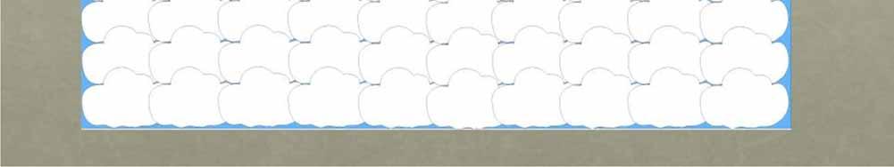
5 Satellite View of Clouds What the Students Observe Mountains with snow & ice

6 Be ready with an answer in 5 seconds! Imagine this picture represents a certain number of clouds in the sky!


7
8

9 Results from Cloud Cover 120 Number of Estimates Total Guesses = 726 Average Guess =?66.4 Correct Answer =? Estimated Cloud Amount (%)
10 Let s Pause for Questions
11 About the Product 1. Using NASA Satellite for Grades Correlates to National Science and Math Standards: - Energy in the Earth System - Data Analysis and Probability 3. Time for each Module:20-30 min; Problem Based Learning: minute class periods 4. Individual or paired activity 5. Materials 6. Basic knowledge of the layout of the country
12 Poll Audience Have you used data from NASA satellites with your students? Yes X No

13 NASA Connection An overview of meteorological satellites
14 The GOES POES Program Geostationary Operational Environmental Satellites Polar Operational Environmental Satellites


15 Geostationary Orbit


16 Polar Orbit
17 Poll Audience Use the characteristics for GOES and POES below to determine the satellite used to monitor ice bergs? A. Geostationary Image resolution is not very good because of distance from earth Can not see the poles very well Can view only one hemisphere B. Polar Image resolution is good because it s closer to earth Sees the poles about 14 times a day Sees tropical and middle latitude regions twice a day
18 Let s Pause for Questions


19 The Lesson: Satellite Meteorology
20 Student Activity Monitoring the Global Environment Students will be able to interpret data from environmental satellites and draw conclusions from those data. Part 1: Investigating climate change Part 2: Problem Based Learning Biomass burning and global climate change


21 Featured Activity


22 GLOBAL MONTAGE
23 Featured Activity GOES spots forest fires and monitors biomass burning Satellite Sounders detect trace gases in the atmosphere Biomass Burning and Global Climate Change POES monitors the pulse of the planet (The EOS program) Satellite Images from the MODIS radiometer
24 Urban Heat Islands Remote Sensing Using Weather Satellites Introduce students to Urban heat Islands Identify Urban areas in Northeast United States


25
26 Let s Pause for Questions


27 Satellite observations in education
28 Assessment Questions If POES flies so much closer to the Earth than GOES, why bother using instruments on GOES to monitor things like forest fires or biomass burning? Problem-Based Learning Global Climate Change Analyze the cause-and-effect relationships of a warming climate Discuss use of satellite technology to study climate change Create a presentation of policy recommendations for the Governor


29 Teacher's Guide
30 QUESTION I will be interested in using GOES and POES satellites data with my students. YES NO NOT Sure YET

31 Let s Pause for Questions


32 Global Climate Change


33


34 gov/


35 Google Earth Downloads:latest.kml (Google Earth file) In the Layers panel turn on the Weather options
36 Let s Pause for Questions


37 NASA Explorer Schools Forums One forum for each module


38 NASA Explorer Schools

39 Thank you to the sponsor of tonight's Web Seminar:


40


41

42 National Science Teachers Association Dr. Francis Q. Eberle, Executive Director Zipporah Miller, Associate Executive Director Conferences and Programs Al Byers, Assistant Executive Director e-learning NSTA Web Seminars Paul Tingler, Director Jeff Layman, Technical Coordinator LIVE INTERACTIVE YOUR DESKTOP