7/11/2018. Floodplain Management Association - June 14, 2018 luncheon
|
|
|
- Adrian Dean
- 5 years ago
- Views:
Transcription


1 7/11/2018 Floodplain Management Association - June 14, 2018 luncheon Len Materman Executive Director San Francisquito Creek Joint Powers Authority len@sfcjpa.org San Francisquito Creek 1998 flood Palo Alto East Palo Alto, flood 1


2 Current and increasing risk to shoreline areas in the San Francisquito floodplain A government agency creating and implementing a common vision among multiple jurisdictions, where public and private entities share the many costs and benefits of a regional approach. Pacific Ocean Water is a shared resource, and its quality, supply and flood safety are connected. San Francisco Bay San Francisquito Creek San Mateo County Flood Control District Menlo Park East Palo Alto Palo Alto Santa Clara Valley Water District 2


 Bay floodplain")
 6 miles SFCJPA Governance and Funding A")
 who are elected officials appointed by the governing body")


 plus")


3 The Big Picture: San Francisquito Creek area Floodplains and Projects San Francisco Bay East Palo Alto Menlo Park SF Bay-Hwy 101: constructing bridge, levees, and floodwalls Upstream of Hwy. 101: EIR of bridge, bank, basin, floodwall Shoreline: planning & design Palo Alto Approximate number of parcels in the 100-year floodplains Creek floodplain only (3,500 parcels) Bay floodplain only, 3 Sea Level Rise (over 2,700 parcels) Overlap of creek and Bay floodplains (2,200 parcels) 6 miles SFCJPA Governance and Funding A five member Board of Directors composed of one member (and one alternate) who are elected officials appointed by the governing body of each of the five founding agencies. Annual operating budget is approximately $1 million % from founding agencies, 5-10% from grant overhead. Capital projects funding: since 2010, $97 million committed in cash or in-kind to plan, design, construct, and maintain SFCJPA projects. 52.6% from 5 founding agencies (mostly SCVWD ballot measure) plus local sewer district 35.2% from State Caltrans, Dept. of Water Resources, Coastal Conservancy 10.6% from PG&E, local sewer district, Facebook 1.6% from federal government Potential funding sources being explored New finance district bond Bay Restoration Authority regional tax to enhance shoreline Aggregated private flood insurance Companies/utilities/developers Cap & trade carbon market 3


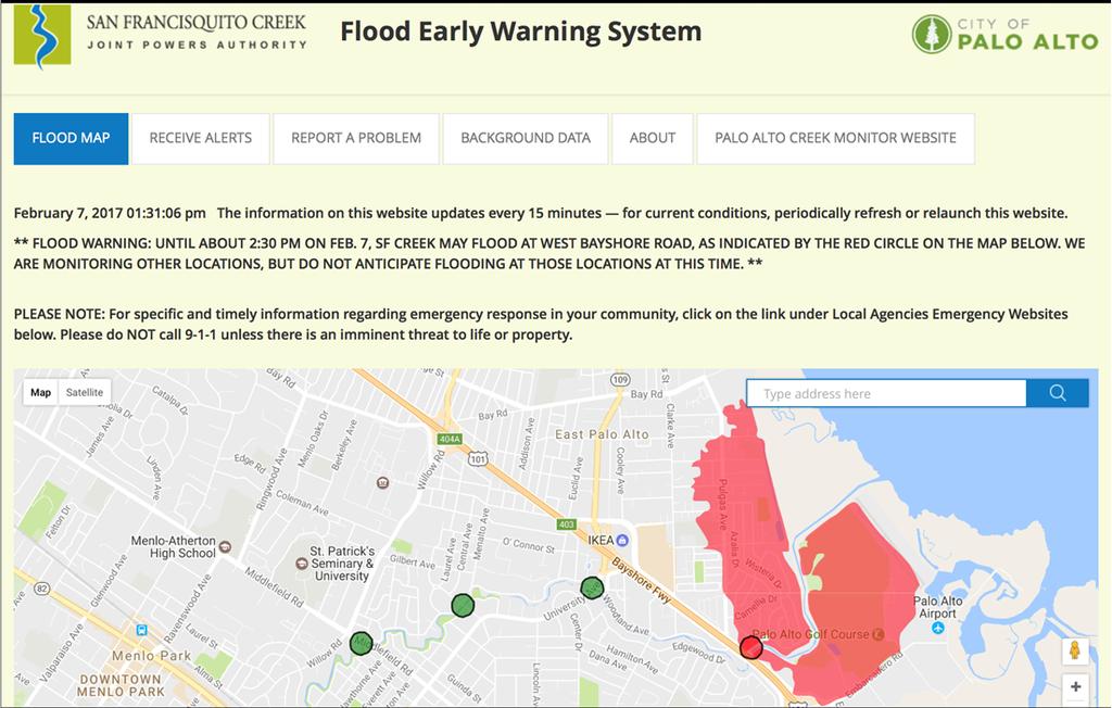
4 7/11/2018 San Francisquito Creek S.F. Bay-Highway 101 Project Two miles of bank/shoreline under construction through 2018 Protect against any creek flow in this tidal area when sea level is up to 10 feet above today s high tide Build horizontal levee in marsh Create/restore 22 acres of habitat for multiple endangered species within the widened creek and adjacent marsh Enhance access to recreational/commuter trails Friendship Bridge Upgrade major gas, electric and sewer lines Provide recycled water to East Palo Alto from Palo Alto East Palo Alto Degrade Bay levee Levees Gas and sewer pipelines Excavate sediment and create marsh transition zones Palo Alto Enhance trail access Floodwalls Feb. 7, 2017 (18-year flow event) Dec. 5, 2017 (King Tide, no creek flow)october


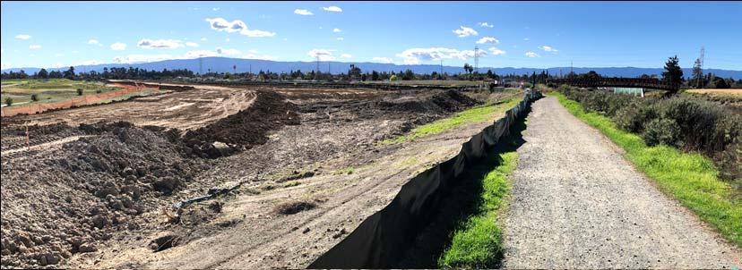

5 7/11/2018 S.F. Bay Hwy. 101 Project: before and after construction Dec


6 2018 Ridgway s Rail Buffer Zone No mechanized work between Feb. 1 - Aug. 31 Work in this area takes over 6 weeks + No work in channel between Oct June 15 due to steelhead migration = Sept. 1 Oct. 14 ALL CLEAR Thus, we asked the US Fish & Wildlife Service to amend our Biological Opinion to allow variances to the buffer zone for specific construction activities late in the breeding season (after July 1). New levee Upstream of Highway 101 Project Modeled floodplain of 1998 sized event Before project is constructed After project is constructed street surface flooding only 6


 flow under Middlefield Road Bridge Widen creek at Hwy.")
7 Alternative 2 concludes with replacing the Pope-Chaucer Bridge After Bay-Hwy. 101 project is complete in 2018, the location with the least capacity is the Pope-Chaucer Bridge. Replacing that bridge would send more water downstream than the channel could handle, causing flooding to new areas. San Mateo County side The preferred JPA project because it is meaningful and achievable is to widen only the sections downstream of the Pope-Chaucer Bridge to accommodate that additional flow under Santa the Clara bridge. County side Pope-Chaucer Bridge Hwy. 101 alternatives so the Creek can contain the maximum (1998 flood) flow under Middlefield Road Bridge Widen creek at Hwy. 101 and Replace or modify Pope-Chaucer and modify specific areas downstream to accommodate increased flow: Replace railing at Woodland & University and either: Widen creek bottlenecks or Construct floodwalls Project of the City of Palo Alto to replace Newell Bridge 7


8 The most effective detention basins are west of Hwy. 280 Searsville Former Boething Nursery Webb Ranch SLAC When projects from Pope-Chaucer to S.F. Bay are complete, these basin(s) would begin filling during flows larger than what Pope-Chaucer could pass. A basin at Webb or Searsville could bring a 100-year event to below the flow capacity of a new Pope-Chaucer Bridge. 8
9 Upstream of Highway 101 Project EIR will: A. Provide context and cohesion for a broad program of projects S.F. Bay to Highway 101 Highway 101 to Pope-Chaucer Bridge Pope-Chaucer Bridge to Searsville Reservoir B. Discuss the 16 alternatives resulting from the 2017 Scoping Period, and screen out most of them C. Evaluate the alternatives/elements to provide 70-year flow protection: widen the creek upstream of West Bayshore Road replace the railing at Woodland & University, and raise capacity by widening creek bottlenecks or constructing floodwalls replace or modify Pope-Chaucer Bridge construct one or more upstream detention basin(s) D. Recommend a meaningful, achievable project for the SFCJPA Board to move forward with now, and a project for additional protection later S.F. Bay to Pope-Chaucer Bridge Projects May 2018 Est. Amt. S.F. Bay Highway 101 * $75,250,000 Replace Pope-Chaucer, match channel capacity to Hwy. 101 $24,500,000 Total Estimated Costs $99,750,000 Total funds available as of May 2018 * $85,450,000 Estimated funding needed $14,300,000 9


10 Comprehensive Agreement to fund construction of Creek projects Costs above Funding Agreement for Bay-Hwy. 101 project levees, floodwalls, and restoration + Costs to monitor, report and maintain Bay-101 restoration for 10 years + Costs to implement the Upstream of Hwy. 101 project selected for construction in EIR Comprehensive Agreement costs Potentially funded by: external grants, new finance district, Corps of Engineers, Member Agencies, private interests, aggregated private flood insurance The Big Picture: San Francisquito Creek area Floodplains and Projects San Francisco Bay East Palo Alto Menlo Park SF Bay-Hwy 101: constructing bridge, levees, and floodwalls Upstream of Hwy. 101: EIR of bridge, bank, basin, floodwall Shoreline: planning & design Palo Alto Approximate number of parcels in the 100-year floodplains Creek floodplain only (3,500 parcels) Bay floodplain only, 3 Sea Level Rise (over 2,700 parcels) Overlap of creek and Bay floodplains (2,200 parcels) 6 miles 10


11 San Francisco Bay SAFER Bay Project Creek project under construction links two-county SAFER shoreline Project objectives along 11 miles of shoreline in two counties and three cities: Protect 5,000 properties & major infrastructure from flooding during a sea level up to 9 feet above today s high tide Create and utilize shoreline marshes for protection in a way that sustains them Expand opportunities for recreation and connectivity Meet objectives regardless of neighboring action/inaction Utilize innovative financing strategies that reflect the diversity of beneficiaries Non-housing assets at risk from and challenges to protecting against Sea Level Rise San Francisco Bay East Palo Alto Menlo Park Business Electricity & gas Transportation Water supply & treatment Palo Alto Over 1,700 acres of existing or potential green infrastructure. Marshes can provide, and be sustained by, flood protection. 6 miles 11


12 Current ground elevations in the area Daily high tide = 7 ft. King tides = 9-11 ft. Elevation (feet) < > 15 East Palo Alto State roadway = Current concerns in one area: Inadequate tidal / SLR protection for homes, roads businesses, and utilities Substantial development planned, underway or completed Transportation gridlock on critical State roadways Existing salt ponds and marshes in need of restoration or enhancement Bay Trail gap Can one regional effort address several of these issues? 12

13 A key segment of the SAFER project Current hardened shoreline No 100-year tide, freeboard, or SLR protection Four alternatives for a new hardened shoreline General area that could become tidal 13


14 AM PM SAFER Bay along East Palo Alto s shoreline Coordination with long-term improvements to Bay Road and development of nearby parcels for a new downtown Existing trail Existing EPA homes New EPA development 14


15 Opportunities for innovations in flood protection A horizontal levee: creates habitat zones to sustain levee and marsh captures and stores carbon may cost less Challenges: finding right soil, regulatory approval A hydrostatic floodwall is a flat road or trail until floodwaters raise a wall. Challenge: approval for State of CA roads Regional considerations: Opening marshes here would affect sea level in other areas of S.F. Bay 15
16 16