DOG RIVER AND GARROW S BEND STEERING COMMITTEE MEETING. Dog River Garrow s Bend Watershed Management Plan
|
|
|
- Lynne Fields
- 5 years ago
- Views:
Transcription

1 DOG RIVER AND GARROW S BEND STEERING COMMITTEE MEETING Dog River Garrow s Bend Watershed Management Plan DOG RIVER GARROW S BEND
2 Plan Development & Ongoing Efforts DOG RIVER GARROW S BEND

3
4
5
6 Community Engagement Update DOG RIVER GARROW S BEND

7 Focus Group Youth/Educators Part 1 Weekly questions about Watershed 101 and Redfish video segments Filmed segments with MBNEP staff Part 2 Four week video creation competition
8 Geographic Mike Magnoli - PMCG Leveraging Elected Officials Information distributed through City and County elected officials Newsletters, Social Media, etc. Collection of information into online survey

9 Online 1. Survey has been broadly distributed to meeting invitees and others through the Steering Committee responses 3. Future opportunities for engagement (Round 2) to be posted on website

10 Online Top three issues the WMP should focus on? As of: Dec 12, 15

11 Online Top three issues the WMP should focus on? As of: Mar 30, 16
12 Characterization Update DOG RIVER GARROW S BEND

13

14


15

16

 Model")

17 Effects of imperviousness on runoff and infiltration (Arnold and Gibbons, 1996) Impervious Cover (IC) Model (Scheuler, 2003) Reformulated IC Model (Scheuler et al, 2009)

18 Classification Sensitive Impacted Non-Supporting Urban Drainage 0%-10% 11%-25% 26%-60% 61%-100% Percent Coverage 59.47% 15.08% 17.20% 8.25% Classification Transition Band Sensitive to Impacted 5%-10% Band Impacted to Non- Supporting 20%-25% Band Non-Supporting to Urban Drainage 60%-70% Band Percent Coverage 8.77% 5.24% 3.18%
19 Conditions Update DOG RIVER GARROW S BEND

20 ESA I Environmental Science Associates Doug Robison, PWS ESA is where solutions and service meet.
21 Ongoing ESA Work Efforts Water quality data summary & analysis Stormwater/wastewater assessment Non-point source loading model development Water and nutrient budget development SLAMM model development


22 Stakeholder Water Quality Concerns Trash Sediment Sewer overflows Algae blooms Safe fishing & swimming

23 Water Quality Parameters of Concern Dissolved oxygen Critical for healthy fish & shellfish populations Measure of organic enrichment Chlorophyll-a Measure of algal production and organic enrichment Bacteria Indicator of human pathogens Heavy metals Accumulate in sediments & food chain
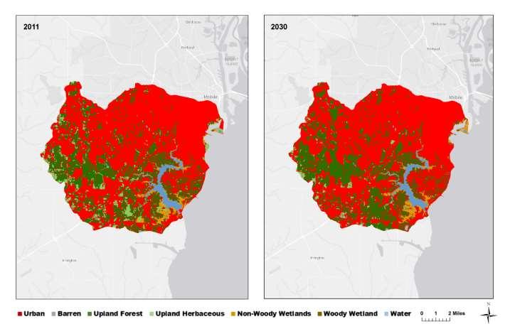
24 Water Quality Data Sources Alabama Department of Environmental Management (ADEM) Dog River Clearwater Revival (Volunteer) Mobile Bay National Estuary Program (MBNEP) U.S. Geological Survey (USGS) Geological Survey of Alabama Mobile Area Water & Sewer System (MAWSS)

25 Water Quality Sampling Sites
26 Dog River Watershed Impaired Water Bodies Tributary/Segment Halls Mill Creek Bolton Branch Eslava Creek Rabbit Creek Dog River Impairments Siltation (303(d) list) Pathogens (approved TMDL) Pathogens (approved TMDL) Organic Enrichment (approved TMDL) Pathogens (approved TMDL) Organic Enrichment (approved TMDL) Pathogens (approved TMDL)
27 Water Quality Conclusions There is adequate existing data to generally characterize water quality status & trends Water quality conditions in the Dog River and its tributaries are generally poor Sediment Organic enrichment Bacteria TMDLs have been established by ADEM to begin addressing the major problems Siltation (sediment) Organic enrichment (nutrients) Pathogen (bacteria)
28 Non-Point Source Loading Model GIS-based model Links key watershed parameters Topography Land use Soil types Applies actual rainfall data Calculates annual runoff pollutant loads Nutrients, sediment, and heavy metals Based on actual event mean concentration (EMC) data measured in the southeastern U.S.

29 Watershed Topography

30 Watershed Soils

31 Estimated Pollutant Loadings by Sub- Watershed Greatest pollutant loads are from the Upper Dog River Greatest hydrologic load Differential pollutant loads per unit area among sub-watersheds Differences in land use and soils

32 SLAMM Model SLAMM = Sea Levels Affecting Marshes Model Developed by the U.S. Environmental Protection Agency (EPA) in mid-1980s SLAMM can predict how Dog River coastal wetland habitats change over long time scales in response to: Sea-level rise Sediment accretion Development
33 Coastal Wetland Loss from Sea Level Rise Sea level rise will overrun salt marshes if there is not adequate sediment accretion In highly developed watersheds coastal wetlands can be pinched up against hardened shorelines resulting in complete loss