WHETSTONE RIVER RESTORATION PROJECT - ADDENDUM
|
|
|
- Samantha Hampton
- 5 years ago
- Views:
Transcription
1 DRAFT WHETSTONE RIVER RESTORATION PROJECT - ADDENDUM Upper Minnesota Watershed District February 2, 2015 I hereby certify that this plan, specification, or report was prepared by me or under my direct supervision, and that I am a duly Registered Professional Engineer under the laws of the State of Minnesota. Houston Engineering, Inc E Fish Lake Rd., Suite 140 Maple Grove, MN Phone # HEI No. 5304_005 Date Mark R. Deutschman State Reg. No
2 TABLE OF CONTENTS 1 BACKGROUND AND INTRODUCTION PROJECT GOALS AND DESIGN CRITERIA ALTERNATIVE 2B SETBACK LEVEES LEVEES HISTORIC WHETSTONE CHANNEL RECONSTRUCTION WEIR STRUCTURES TRANSPORTATION FEATURES LAND REQUIREMENTS ALTERNATIVE 2B IMPACT ANALYSIS INTRODUCTION RESTORATION HYDROLOGY FLOODPLAINS AND FLOOD POTENTIAL ECOLOGICAL, WILDLIFE AND WETLANDS WATER QUALITY PRELIMINARY OPINION OF PROBABLE COST PERMITS AND APPROVAL ENGINEER S RECOMENDATION TABLES TABLE 1: FREQUENCY OF DIVERTED MEAN DAILY FLOWS ( ) TABLE 2: PEAK FLOWS RESTORED TO WHETSTONE HISTORIC CHANNEL TABLE 3: EFFECTS OF THE ALTERNATIVES FOR THE HISTORIC FLOOD EVENTS TABLE 4: ESTIMATED FLOODPLAIN ELEVATION CHANGES (100 YEAR EVENT) TABLE 5: ESTIMATED IMPACTS TO BIG STONE NATIONAL WILDLIFE REFUGE (DOWNSTREAM OF HIGHWAY 17) 100 YEAR EVENT TABLE 6: BIG STONE LAKE WATER QUALITY IMPACTS - ESTIMATED ANNUAL LOAD REDUCTIONS TABLE 7: PRELIMINARY OPINIONS OF PROBABLE CONSTRUCTION AND TOTAL PROJECT COSTS FOR THE RESTORATION PROJECT TABLE 8: ADDITIONAL RELATED TRANSPORTATION SYSTEM IMPROVEMENT COSTS (ALTERNATIVE 2B ONLY) TABLE 9: SUMMARY OF THE WHETSTONE RIVER RESTORATION ALTERNATIVES FIGURES FIGURE 1: ALTERNATIVE 2B (WITH SETBACK LEVEE OPTION)... 4 FIGURE 2: SURVEYED CROSS SECTION (STATION 9586) IN HISTORIC WHETSTONE NEAR THE MINNESOTA RIVER... 6 FIGURE 3: PROPOSED TRANSPORTATION SYSTEM MODIFICATIONS... 9 FIGURE 4: PRELIMINARY LAND REQUIREMENTS FIGURE 5: 100-YR DISCHARGE AND ELEVATION AT BIG STONE NATIONAL WILDLIFE REFUGE FIGURE 6: NWI WETLANDS FIGURE 7: NATURAL CHANNEL DESIGN CONCEPT FOR UPPER PORTION OF HISTORIC WHETSTONE RIVER CHANNEL FIGURE 8: CONCEPT DESIGN OF WHETSTONE RIVER DIVERSION STRUCTURE PREFERRED BY MINNESOTA DEPARTMENT OF NATURAL RESOURCES... 28
3 1 BACKGROUND AND INTRODUCTION This document is an addendum to the report titled River Restoration Project Engineer s Report dated February 2, 2015 (hereinafter referred to as the Engineers Report ). The Engineer s Report identified, described and evaluated three alternatives for restoring flow to a portion of the (historic) River channel from near Big Stone City, South Dakota downstream to the confluence with the Minnesota River. During the late 1930 s flow which made it ways through the River to the Minnesota River was effectively diverted into Big Stone Lake to augment lake levels by constructing a new channel to near the lake outlet and a levee system. The three alternatives evaluated within the Engineer s Report differed primarily in the amount of flow restored to the historic River channel. The alternatives evaluated in the Engineer s Report included: 1. Alternative 1, Low Flow / DNR Bankfull Channel: a low flow diversion alternative intended to provide perennial flow confined within the historic channel for discharges equal to or less than the one-half the 2-year return period event (an estimated 550 cfs ); 2. Alternative 2, 2 year Compound Channel: an alternative providing perennial flow by the diversion of all flows equal to or less than the 2-year return period event (an estimated 1,100 cfs) and conveyed within a compound channel consisting of the DNR bankfull channel and an adjacent excavated floodplain and; 3. Alternative 3, 5-year Channel / Riparian Flow: an alternative providing perennial flow by the diversion of all flows equal to or less than the 5-year return period event (3,200 cfs) conveyed within the historic channel. The alternative names fail to reflect that additional flow will be diverted and carried by the adjacent floodplain. Because of a lack of information about the ability to acquire land along the historic channel, each alternative included levees designed next to the open channel (not setback) to various levels of flood protection. These levees were designed to ensure the amount of land flooded adjacent to the historic channel remained the same as the current condition, for events up to the 10% annual chance flood event. Each alternative also included various features necessary to allow water to reenter the historic channel and pass additional flow under road crossings. These features included a diversion structure on the River to raise the water level and divert flow into the historic channel, excavation of an embankment, excavation of upstream portions of the historic channel to remove accumulated sediment and debris, and culvert and bridge upgrades at Minnesota County State Aid Highway 15 (CSAH 15) and South Dakota (Grant County) County Road 47. A full description of these alternatives is provided within the Engineer s Report. Following the completion of the Engineer s Report, District staff and the District Engineer had several meetings to solicit input about the project. Houston Engineering, Inc. (the Engineer ) completed the draft Engineer s Report on June 5, 2014 and orally presented the report to the Upper Minnesota River Watershed District Board (the District) of Managers on July 8, 2014 during their regular meeting. The District convened the Technical Advisory Committee on October 21, 2014 to present the restoration alternatives and receive comment. Several meetings were held with potentially affected landowners. Department of Natural Resources staff became more engaged, assisting with the definition of the restoration design concept and provided considerable input and suggestion through correspondence. As a result of these discussions, the Board requested the District Engineer to consider the input received and further evaluate the initial recommendation and to revise the recommendation if necessary. The purpose of this document is to present a revised Engineer s Recommended Alternative with modifications based upon the landowner and public discussions, as an addendum to the Engineer s Report. It is intended that this addendum, WHETSTONE RIVER RESTORATION ADDENDUM 1
4 coupled with the findings of the Engineer s Report, will be used by the Board to order a project containing the components outlined in their preferred alternative. This addendum is necessary because of more detailed information about the availability of land adjacent to the historic channel, discussions with Grant County South Dakota and Big Stone County Minnesota about the project s transportation features, and input from the Minnesota Department of Natural Resources on the restoration design concept. 2 PROJECT GOALS AND DESIGN CRITERIA The goal of the proposed project is to restore ecological services by reestablishing perennial flow and increasing base flow to an estimated 9,000 and 7,000 feet of open channel within the River and Minnesota River, respectively. In addition, floodplain areas of the Big Stone National Wildlife Refuge (Refuge) will also receive ecological services restoration from increased flows. The portions of the River and the Minnesota River being restored are generally located downstream of the Big Stone Dam and upstream of the Highway 75 dam, within western Minnesota. The hydrologic regime within these portions of the Minnesota and River became substantially altered when the River was diverted into Big Stone Lake to supplement water supply within the lake. The proposed project diverts a portion of the discharge from the River entering Big Stone Lake into a segment of the historic River channel, upstream of the lake. This historic channel connects to the Minnesota River downstream of the Lake. Restoring ecological services will be accomplished by: 1. Establishing longitudinal connectivity within the historic stream channel of the River by creating a hydrologic connection between the River upstream and the Minnesota River downstream; 2. Establishing lateral connectivity between the riparian area and the historic stream channel of the River by creating a hydrologic connection between the River upstream and the Minnesota River downstream; 3. Improving the habitat along the existing riparian corridor for the movement of animal species; 4. Establishing a geomorphologically stable open channel system. The project goals include establishing hydrologic predictability to landowners adjacent to the restored portion of the historic channel. Hydrologic predictability means establishing a reasonable expectation of the frequency in which lands in agricultural production adjacent to the channel will experience flooding. Minimizing the amount of land and identifying the likely area of land which could experience accumulations of debris and sediment as a result of the diversion is included in the goal. This project is potentially one component of a larger project aimed at restoring portions of the River and the Minnesota River, upstream and downstream respectively. An additional goal is to design and construct this project, in a manner which does not preclude subsequent design and construction of other restoration components. Design criteria were also established in addition to the project goals. These design criteria, used in conjunction with Project Goals, were used to size the various features of the proposed alternatives and select an alternative capable of meeting the goals and design criteria. The design criteria used for developing each alternative include: The restoration of ecological services along the historic River channel, consistent with the project goals, which include design of the open channel and setback levees in a manner which reestablishes the lateral and longitudinal connectivity of the floodplain. WHETSTONE RIVER RESTORATION ADDENDUM 2
5 Providing for fish passage in accordance with Minnesota Department of Natural Resources guidelines. These guidelines include when feasible the use of a single culvert or bridge which spans the natural bankfull width to allow for debris and sediment transport rates to closely resemble those of upstream and downstream conditions. Provide for a single culvert to be recessed in order to pass bedload and sediment load, where appropriate, with additional culvert inverts set at a higher elevation. All culverts should match the alignment and slope of the natural stream channel, and extend through the toe of the road side slope. Consideration of the frequency of potential roadway overtopping of SD Grant County 47 (CR 47) and MN County State Aid Highway 15 (CSAH 15) and transportation movement within the project area. Crossings were designed to prevent overtopping during a 100-year event and provide fish passage. Protection of tillable agricultural lands located beyond the levees up to the 10-year return period event and residences and commercial businesses to the 100-year return period event. 3 ALTERNATIVE 2B SETBACK LEVEES This addendum presents a new alternative for consideration by the Board of Managers. The alternative is named Alternative 2B Setback Levees because the amount of water diverted into the historic River Channel is equal to or somewhat greater than the amount diverted by Alternative 2 (as presented in the Engineer s Report). This alternative differs from Alternative 2 by incorporating levees setback from the centerline of the historic channel, rather than the levees being located immediately adjacent to the historic channel. Setting the levees back in this manner improves the quality of the restoration project by creating greater lateral connectivity between the stream channel and the riparian floodplain. This alternative also envisions modifying the cross-sectional geometry of those portions of the channel needing excavation to a more natural shape. Alternative 2B is possible provided the land needed can be acquired and generally is more characteristic of a restoration project. Alternative 2b is designed to achieve the project goals in Section 2 by diverting the largest reasonable discharge through the restored channel, while being consistent with the stream restoration purpose. This alternative envisions an open channel geometry and slope which results in full channel flow for the bankfull discharge, which has recently been estimated at 475 cfs by the Minnesota Department of Natural Resources (MnDNR). This alternative will completely divert all River discharges up to at least 1,100 cfs through the restored historic River channel (1,100 cfs represents the 2-year discharge for the River). The portion of the discharge between the bankfull discharge and the 2-year discharge will be carried by an excavated floodplain bench. Only a portion of the discharge in excess of the 2-year return period event within the River is diverted to the restored channel. Figure 1 shows the non-transportation related features of this alternative. The following paragraphs describe the alternative with further detail. 3.1 LEVEES Existing agricultural levees are present along much of the historic channel. However, downstream of CSAH 15 the agricultural levees are more pronounced and currently provide flood protection to agricultural lands from the Minnesota River. To provide lateral connectivity between the open channel and the riparian area with the floodplain, these existing levees will need to be breached intermittently at a distance of no less than 500-feet. As flow increases this will allow water to leave the channel and become stored within the adjacent floodplain. WHETSTONE RIVER RESTORATION ADDENDUM 3
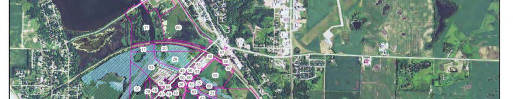
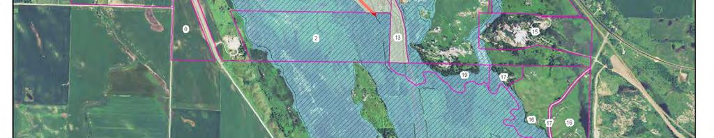
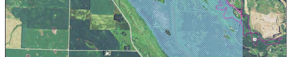
6 Figure 1: Alternative 2B (With Setback Levee Option) WHETSTONE RIVER RESTORATION ADDENDUM 4
7 East of CSAH 15 and just north of the historic alignment there is a private residence requiring flood protection. A levee encircling the residence (i.e., a ring dike) is proposed to protect this residence to the 1% chance flood with 3 feet of freeboard. The ring dike will be approximately 1,800 linear feet in length and range from 5.0 to 8.6 feet above natural ground based on preliminary hydraulic analysis. The ring dike will be constructed with a 16-foot top width and 4:1 side slopes. Tillable agricultural land beyond the setback levees will to be protected up to the 10% chance flood event, while residences and businesses will be protected to the 1% chance flood event with 3 feet of freeboard (see Figure 1). An estimated 8,000-feet of agricultural levee are needed. One levee segment will be south of the historic from CR 47, extending south to tie-in with existing levees within U.S. Fish and Wildlife lands. The north segment will extend from the Dwyer rink dike and extend east to tie-in with existing agricultural levees along the Minnesota River. The top of levee elevation for the agricultural levees will range from 0.0 to 8.3 feet above natural ground based on preliminary hydraulic analysis. The agricultural levees will be constructed with a 16-foot top width and 4:1 side slopes. The agricultural levees are located at a minimum offset distance of 500- feet from the historic channel centerline. The offset distance exceeds the minimum distance of 250-feet recommend by the Minnesota Department of Natural Resources. Expectations are that on-site materials will be used to construct the agricultural levees. An additional 2,470 linear feet of business/residence levees between CR 47 and CSAH 15 on the north side of the historic is needed. These certified levees will protect several businesses south of Mill Road for events up to and including the 1% chance flood with 3 feet of freeboard. The top of levee elevation for these levees will range from 2.7 to 11.2 feet above natural ground based on preliminary hydraulic analysis. These levees will be constructed with a 16-foot top width and 4:1 side slopes. 3.2 HISTORIC WHETSTONE CHANNEL RECONSTRUCTION Since the River was diverted into Big Stone Lake in the 1930 s the elevation of the channel bottom has lowered an estimated 4.5 feet, based on survey data collected for this project and the current invert of the historic channel. This headcutting within the River was likely caused by shortening the stream reach, which increased the channel slope and the energy of flowing water. Hydrology has also likely changed through time due to upstream land use changes (increased discharges). An embankment currently blocks discharge from entering the historic river channel. This embankment is effectively a portion of the levee believed to be constructed when the River was diverted into the lake. The embankment is connected to the Big Stone Lake Dam embankment. The embankment is approximately 600 feet West of CR 47 and contains a 2 diameter culvert. Excavation through this embankment will be required to reconnect the historic River channel to the River. Excavation and removal of the embankment is proposed beginning 1,960 feet upstream from the Highway 12 Bridge and continue to approximately 1,500 feet downstream from CR 47 for a total distance of an estimated 2,960 linear feet. In order to restore flow, the historic channel can be either excavated to the elevation of the current River channel (964.01) or the current bottom elevation (flowline) of the historic channel (968.0). Excavation of the historic channel to near an elevation of is recommended. Raising the River channel bottom to the historic flowline could result in a less entrenched channel upstream of the restored portion on the River, which may reduce head cutting and reconnect discharges with the floodplain 1 All elevations reference North American Vertical Datum of 1988 (NAVD 88) WHETSTONE RIVER RESTORATION ADDENDUM 5 5
8 upstream of the project. However, raising the elevation of the River channel bottom is likely more challenging from a construction perspective and changes the channel slope of the River relatively little within the unstable portion of the river. Raising the flowline of the River channel bottom to elevation reduces the discharge capacity through the historic channel, reduces the amount of water which can be diverted at higher discharges and therefore reduces the potential flood damage reduction benefits on Big Stone Lake. This lost capacity could be offset by excavating a floodplain bench along the historic channel and/or raising the elevation of the diversion weir structure (discussed below). Alternatively the elevation of the River where flow will be diverted into the historic channel could remain unmodified. To avoid entrenchment of the historic channel a floodplain bench can be constructed adjacent to the bankfull channel along the restored stream. The excavated material may be suitable and could be used to construct the levees. Only the upstream portion of the historic channel would need excavation. The conveyance capacity of the lower portion of the historic channel towards the Minnesota River is generally sufficient to pass the 2-year discharge. This is the recommended method for restoration. During final design, the geometry and slope of the historic channel and the elevation of the diversion structure (see below) will be optimized to ensure capacity is not compromised, adverse impacts on the River are avoided, and the historic restored channel is not entrenched. During final design a stable cross section will be determined. Guidance provided by the Minnesota Department of Natural Resources indicates a desired bankfull cross sectional area of approximately 150 square feet within riffles and 300 in pools. Survey information for several locations along the historic River channel upstream from the Minnesota River indicate a typical top-of-bank to top-of-bank cross sectional area of approximately 290 square feet. An example of a surveyed cross section in this location is shown in Figure 2. On historic aerial photos from 1938 and 1955 several breakout reaches are visible, which may have reduced the discharge historically flowing through parts of the. These breakouts are no longer available. Therefore, we anticipate the final cross sectional area of the excavated portion of the historic channel will include a floodplain bench sufficient to pass the 1.5-yr to 2-year discharge (~800-1,100 cfs). Bankfull area ~ 290 ft 2 Figure 2: Surveyed Cross Section (Station 9586) in Historic near the Minnesota River WHETSTONE RIVER RESTORATION ADDENDUM 6 6
9 The current channel is overgrown with vegetation in many places and contains a substantial amount of downed trees blocking the channel. Clearing will need to take place in the area below normal water levels. Clearing debris, primarily fallen trees and growing trees from the historic channel will be required along the 9,000 foot length. Much of this material will be stockpiled and used as toe wood protection at select locations. 3.3 WEIR STRUCTURES To divert water into the historic channel a plug (i.e., a diversion structure) is needed in the River to raise water levels (see Figure 1). The diversion structure also needs to be designed and constructed in a manner which allows large flows to pass over the top as none of the alternatives are able to pass River flows for all flood events. The proposed diversion structure consists of a sheet pile weir with a crest elevation of approximately located 1,080 feet upstream from the Highway 12 Bridge. The existing channel bottom is The sheet pile weir will be embedded within rock with 3:1 and 12:1 slopes on the upstream and downstream faces, respectively. The design is intended to provide safe passage for fish and recreational canoeists and allow debris and ice to pass through the downstream debris barrier by the dam. Rock arch rapids can be incorporated into the riprap during final design. A second weir structure designed similar to the diversion structure will be constructed at the location where the existing levee is removed near the entrance to the historic channel. The purpose of this weir is to create a hard point to ensure grade control at the inlet of the historic channel. The structure consists of a sheet pile weir with a crest elevation of approximately The sheet pile weir will be embedded within rock with 3:1 and 12:1 slopes on the upstream and downstream faces, respectively. During final design the crest elevation of the structure may be adjusted, as design of the open channel and diversion weir is optimized. 3.4 TRANSPORTATION FEATURES County Road 47 crosses the historic channel approximately 1,800 feet south of Highway 12. The road had an Average Annual Daily Traffic (AADT) of 226 in 2011 based on published maps. The elevation of the road crown is approximately 4-feet above natural ground and 15 feet above the current channel bottom of the River where the road crosses the river. The road appears to consist of 2 11-foot driving lanes and 2-foot gravel shoulders. Shoulder width increases to 5-feet as Highway 12 is approached. The probable right of way is a total of 60-feet. There is currently a 60 by 84 corrugated metal arch culvert under the road where it crosses the historic River. This crossing is to be replaced with a 140-foot span bridge with a total waterway area of 1,140 square feet. This bridge was proposed in Alternative 3 of the Engineer s Report and will allow the largest reasonable discharge to be diverted to the historic, which will provide the greatest impact in regards to reconnecting the floodplain during flood events. CSAH 15 crosses the historic Channel approximately 3,600-feet south of Highway 12 and approximately 3,200 feet east of the River. The AADT for the road was 470 in 2012 based on published maps. The current road elevation is only slightly above the elevation of the surrounding fields. The elevation of the top of the roadway is approximately 10-feet above the current historic channel and appears to consist of 2, 12-foot driving lanes with 4-foot paved shoulders. There is currently one line of 48-inch reinforced concrete pipe where the road crosses the historic channel of the River. From their intersections with Highway 12 to approximately 1.0 miles south of the historic, CR 47 and CSAH 15 are redundant. Approximately 1.0 miles south of the historic River the two highways converge to within 240-feet of one another with a small connection road in-between. These highways then both extend north, crossing the historic and meet Highway 12 approximately 0.7 miles apart from each other. These roads are also connected on the north side of the and south of Highway 12 by Mill WHETSTONE RIVER RESTORATION ADDENDUM 7 7
10 Road, which has several businesses. Between the south connection and Mill Road on CSAH 15 there is one access to a residence. Along CR 47 there are five access points to residences and business. The proposed modifications to the transportation system are shown in Figure 3. After preliminary discussions with both the Grant County highway superintendent and Big Stone County Engineer, it was determined that the redundant section of CSAH 15 could be demised (while maintaining access to the residence). This eliminates the need for a second large crossing over the restored River. Demolition of a minimum of 500-feet of CSAH 15 where it currently crosses the historic channel is recommended to restore floodplain flow. The portion of CSAH 15 north of the historic channel is to remain for residential access. The portion of CSAH 15 south of the historic channel to CR 47 will be reclaimed (1,950 linear feet) and a new turf surface established south of the River to the CR 47 connection. With the demolition of MN CSAH 15, new transportation features and upgrades will be required to allow traffic movements to and from Big Stone City and onto Highway 12. The current design of CR 47 is likely to a lesser tonnage than CSAH 15. The road cross section of CR 476 is also narrower than CSAH 15 and therefore driver expectations differ between the two roads. Approximately 7,200 linear feet of improvements to CR 47 are planned. These improvements will entail upgrading CR 47 to a cross section consisting of two 12-foot lanes with 4-foot aggregate shoulders. An estimated 40-feet of additional ROW (6.2 acres) is needed to construct the road, assuming no change in current grade. A new connection will be made between CSAH 15 to CR 47 by construction a horizontal curve with a 60- mph design speed. A new connection from CR 47 to CSAH 15 is also be needed and will consist of a 45-mph horizontal curve (890 linear feet) with a stop connection at CSAH 15. With the improved intersections, several segments (2,840 linear feet) of existing roadway can be obliterated. This includes the current connection between CR 47 and CSAH 15 and the segment of CR47 north of the new connection and south of the existing connection. In addition there will be 1,100 linear feet of new aggregate surface constructed to provide several residential accesses. A small field crossing between CR 47 and CSAH 15 is also to be removed. 3.5 LAND REQUIREMENTS A considerable amount of land is needed for the construction of Alternative 2B. All land located between (interior to) the levees is expected to be purchased by the District. Figure 4 shows the preliminary land requirements. A detailed table of land needs is provided in Appendix A: Land Requirements. A total of 254 acres is planned for fee purchase. Levee construction is expected to occur on the land purchased. Temporary easements are necessary to complete construction. Flowage easements are also needed as the proposed project will alter the area inundated by the 1% chance flood event. The area inundated for the 1% flood event on land exterior to the levee system may increase or decrease. Although the net change in the acreage inundated on a specific parcel may be small or even zero, the acquisition of flowage easements for any land newly inundated for the 1% chance flood event (based on a channel design characteristics of Alternative 3 (design of 3,200 cfs) and setback levees of Alternative 2B) is proposed (see Figure 4). An estimated 105 acres is planned for flowage easements. The District will also need access to the proposed diversion weirs for future maintenance, which will be accomplished through approximately 1 acre of permanent right-of-way or easement. Widening CR 47 requires additional acquisition of additional ROW. The current ROW is believed to be 60-feet total. Acquisition of an additional 40-feet is proposed. Existing roadway ROW will be vacated at select locations. WHETSTONE RIVER RESTORATION ADDENDUM 8 8
11 Figure 3: Proposed Transportation System Modifications WHETSTONE RIVER RESTORATION ADDENDUM 9 9
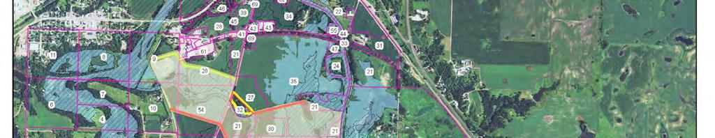
12 Figure 4: Preliminary Land Requirements WHETSTONE RIVER RESTORATION ADDENDUM 10 10
13 4 ALTERNATIVE 2B IMPACT ANALYSIS 4.1 INTRODUCTION The designs of the various alternatives including Alternative 2B (i.e., Alternative 2 with Setback Levees) described within the Engineer s Report and this addendum are conceptual. This means preliminary sizes, lengths, dimensions and elevations of the various project features (e.g., the crest elevation of the River diversion weir) have been determined and the function and probable performance evaluated using the hydrologic and hydraulic models. Based on these dimensions an estimate of the Preliminary Opinion of Probable Construct Cost (POPCC) is provided with an appropriate contingency, reflecting some design uncertainty. Should the Board of Managers decide to proceed with a restoration project, additional design will be required for the selected alternative. The potential impacts resulting from Alternative 2B and described within this portion of the Addendum are based on the functional design of Alternative 2. The effects of setting the levees back from the channel are yet to be explicitly modeled. Optimization of the design characteristics of the River Diversion weir, the elevation of the historic channel bottom, and the restored channel geometry will be need to be coordinated with the Minnesota Department of Natural Resources. The performance and potential impacts described within this section for Alternative 2B reasonably reflects the consequences of project implementation. 4.2 RESTORATION HYDROLOGY The purpose of the restoration project is to return perennial flows to the historic channel of the River. The amount of water which can potentially be diverted into the historic channel is primarily a function of the elevation of the River diversion structure (i.e., the amount of head created), the cross sectional area and elevation of the excavated portion of the historic Channel, and the effect of the downstream structures under CR 47 and CSAH 15. Downstream water levels on the Minnesota River also can affect the amount of water diverted. For all three alternatives, placing the diversion weir in the existing channel combined with channel excavation will restore flow into the historical channel on a daily basis. Table 1 provides details on the anticipated regularity of daily discharges in the. These values are based on the daily discharge record at the USGS gaging station on the River near Big Stone City and the capacity of the historic channel. Each alternative accomplishes the purpose of returning perennial flows to the historic channel. WHETSTONE RIVER RESTORATION ADDENDUM 11 11
14 Condition Table 1: Frequency of Diverted Mean Daily Flows ( ) Average Days per year flow diverted to Historical Channel Average Days per year flow to Big Stone Lake (Current ) Existing Alternative 1 Low Flow / DNR Bankfull Channel Alternative 2 2 Year Compound Channel Alternative 3 5 Year Channel, Riparian Maintenance <1 Typically restoration projects such as this are initially designed and their performance analyzed by engineers using design events. Design event hydrographs are those with a certain shape and estimated peak discharge and a probability assigned based on the typical likelihood of a hydrologic event occurring. Design events are the typical method used to size project features, and are useful for analyzing how the proposed features will perform for a range of differing amounts of runoff, which are likely to occur during the life of the proposed features. These events are referred to by an annual probability or sometimes an average recurrence interval. For example the 100-year flood event is the flood event that has a 1% chance of being exceeded on average in any given year. Table 2 summarizes the estimated peak discharge and the proportion of that discharge diverted to the historic channel for the three alternatives. For example, during the 100-year flood event with Alternative 2, 28% of the peak discharge will be diverted to the historic. A much larger portion of the total volume of the flood event will still be diverted to the historic. The amount diverted under existing conditions is virtually none. WHETSTONE RIVER RESTORATION ADDENDUM 12 12
15 Table 2: Peak Flows Restored to Historic Channel Alternative 1 Low Flow / DNR Bankfull Channel Peak Flow to Restored (cfs) Alternative 2 2 Year Compound Channel Peak Flow Restored to (cfs) Alternative 3 5 Year Channel, Riparian Maintenance Peak Flow to Restored (cfs) Total Flow (cfs) % of peak diverted % of peak diverted % of peak diverted 2-year % % % 5-year % % % 10-year % % % 50-year % % % 100-year % % % These flow splits assume ice at the Highway 12 bridge Often, local residents can gain more perspective on the impacts of a project by analysis of historical runoff events than design events. The impacts the project would have, had it been in place, during the big one can be more relevant to those living in the area. As such, the impacts were also analyzed using the 1997 and 2010 flood events. Table 3 shows the effects of each alternative, had the project been in place, during the 1997 and 2010 flood events. WHETSTONE RIVER RESTORATION ADDENDUM 13 13
16 Existing Conditions Table 3: Effects of the Alternatives for the Historic Flood Events Alternative 1: Low Flow / DNR Bankfull Channel Alternative 2 & 2B**: 2 Year Compound Channel Alternative 3: 5 Year Channel, Riparian Maintenance Big Stone Lake Maximum Elevations* Maximum Maximum Maximum Maximum Change Change Change Elevation Elevation Elevation Elevation Highway 75 Peak Discharge Peak Peak Peak Peak Change Discharge Discharge Change (cfs) Discharge Change (cfs) Discharge (cfs) (cfs) (cfs) (cfs) (cfs) ,335 10, ,885 1,550 12,229 2, ,665 11, ,144 1,479 13,615 2,950 Highway 75 Total Volume*** Total Volume Total Volume Change Total Volume Change Total Volume Change (acre-feet) (acre-feet) (acre-feet) (acre-feet) (acre-feet) (acre-feet) (acre-feet) , ,946 4, ,332 10, ,175 4, , ,476 10, ,446 13, ,551 10,847 Highway 75 Maximum Elevations Maximum Maximum Maximum Maximum Change Change Increase Elevation Elevation Elevation Elevation Peak Flow (cfs) Peak Flow Restored to Historical (cfs) Diversion Split Peak Flow Peak Flow % of peak to Restored to Historical Historical (cfs) % of peak to Historical Peak Flow Restored to Historical (cfs) % of peak to Historical ,593 1,396 21% 2,441 37% 4,345 66% ,394 1,372 21% 2,334 37% 4,299 67% Total Volume (acre-feet) Total Volume Restored to Historical (acre-feet) Diversion Split Total Volume Total Volume Restored to Historical (acre-feet) % of total volume to Historical % of total volume to Historical Total Volume Restored to Historical (acre-feet) % of total volume to Historical ,547 79,843 50% 105,441 66% 146,945 92% ,503 70,742 63% 87,239 78% 108,434 96% * The existing 100-year floodplain elevation for Big Stone Lake established by FEMA is (NAVD88, effective April 17, 2006). ** The effects of alternative 2B are yet to be modeled, but the downstream peak discharge and water surface elevations are expected to be less than Alternative 2 because of the additional floodplain storage between the setback levees. ***If the model was run for a long enough period of time, such that areas with storage (such as Big Stone Lake) were allowed to find the same equilibrium at their initial starting condition and ending condition, these volumes would be equal for all alternatives. These volumes indicate that the timing of volumes is changed dependent on the alternative. WHETSTONE RIVER RESTORATION ADDENDUM 14 14
17 These results provide additional information about the performance of the alternatives. The results show the proportion of the peak discharge entering the historic channel for Alternative 2 is 1,000 cfs more than Alternative 1 (assuming no setback levees), the additional lowering of the peak water elevation of Big Stone Lake, and the increase in discharge downstream through the wildlife refuge. Remembering that the modeling of the setback levees is still necessary for Alternative 2B, the probable downstream effects will be lessened compared to Alternative 2 (peak discharges and water levels will be lower). Hydrologic restoration is also intended to provide longitudinal and lateral connectivity between the riparian area and floodplain, and fish and wildlife habitat improvement. Longitudinal connectivity means that the water can flow freely from upstream to downstream through the open channel of the stream or river in the absence of barrier (e.g., dams). Lateral connectivity means that the open channel and floodplains carry a proportionate share of their flow; i.e., the land next to the open channel has a reasonable chance of flooding and the open channel of the stream or river does not carry all the flow. From a restoration perspective only Alternative 2B achieves lateral connectivity as conceived. Alternatives 1, 2, and 3 are inconsistent with the goal of establishing lateral connectivity, because the levees to provide protection of agricultural lands are placed immediately adjacent to the historic channel and the flow is largely carried by the open channel. The levees were placed adjacent to the channel for these alternatives because the amount of land that could be acquired was unknown. Consistency with the goal of lateral connectivity can be easily accomplished for Alternatives 1, 2 and 3 by setting the proposed levees back from the historic channel as done in Alternative 2B. 4.3 FLOODPLAINS AND FLOOD POTENTIAL Because a considerable portion of the water moving downstream in the River will be diverted into the historic channel, the location of the floodplain and lands affected will change. In general, a considerable portion of the flow from the River (i.e., 21% of the peak discharge for the historic floods) will no longer reach Big Stone Lake, reducing flood elevations on Big Stone Lake. Following the 1997 flood, the low floor elevation of 172 inhabited structures on only the Minnesota side of the lake were surveyed by the Upper Minnesota River Watershed District and Big Stone County. Currently 72 structures are lower than the 100-year lake elevation of Alternatives 1, 2, and 3 reduce the number of structures to 57, 50, and 17 respectively. Alternative 2B is expected to reduce the number of structures similar to Alternative 2. The 100 year flood elevation decrease ranges from 0.65 feet to 2.02 feet, depending on the alternative. The maximum elevation decrease, assuming all discharges are diverted was calculated to be 2.7 feet. Water which is diverted through the historic channel will reach downstream areas more quickly, and potentially increase the maximum water depth. Table 4 shows the changes in maximum water surface elevation on Big Stone Lake, the Refuge, and at the Highway 75 Dam for each of the 3 Alternatives. At the Highway 75 dam the increases in the maximum water surface level compared to existing conditions ranged from 0.24 feet to 0.79 feet for the 100-year flood, depending on the alternative. Table 5 also shows the duration of the increased water surface elevations at the Refuge, and the corresponding increases in peak discharge and water surface elevation. These increases were modeled assuming no changes to the Highway 75 dam operations plan, no changes to the Big Stone Lake Dam, and without setback levees. WHETSTONE RIVER RESTORATION ADDENDUM 15 15
18 Table 4: Estimated Floodplain Elevation Changes (100 year event) Alternative 1 Low Flow / DNR Bankfull Channel Alternative 2 & 2B* 2 Year Compound Channel Alternative 3 5 Year Channel, Riparian Maintenance Big Stone Lake 100 year Elevation Reduction Big Stone National Wildlife Refuge (downstream of Highway 17) Elevation Increase Highway 75 Dam 100 year Elevation Increase *Alternative 2B will be less than alternative 2 because of setback levees. **These reductions assume a 100 year flood on Big Stone Lake caused by a 100 year flood on the River, different flood mechanism could result in less of a reduction Table 5: Estimated Impacts to Big Stone National Wildlife Refuge (downstream of Highway 17) 100 year event Alternative 1 Low Flow / DNR Bankfull Channel Alternative 2 & 2B* 2 Year Compound Channel Alternative 3 5 Year Channel, Riparian Maintenance Elevation Increase (feet) Discharge Increase (cfs) Duration of Water Surface Elevation greater than Existing Conditions (days) Duration of Water Surface Elevation greater than 0.1 feet above Existing Conditions (days) *Alternative 2B will have lower values than alternative 2 because of setback levees. Without the use of the floodplain available because of the setback levees, water is forced through the historic channel quickly, without any attenuation of the peak discharge. Figure 5 shows the discharge and stage hydrographs for existing conditions and each of the alternatives within the Big Stone Lake National Wildlife Refuge. The discharge hydrographs illustrate how discharges stack on top of one another due to the diverted discharge s quick movement through the historic channel. The use of the floodplain adjacent to the restored channel will increase storage and attenuation of the peak discharge, which will reduce the impacts at the Highway 75 dam from what was previously modeled. Therefore, the increase in peak discharge rate, elevation, and duration of increased discharge at the Refuge and Highway 75 dam will be less than Alternative 2. The downstream impacts will be reduced even further with changes to the Big Stone Lake Dam operations procedures. Impacts downstream will decrease if the gates remained closed more often than they would during the current operation plan. Additionally modifications to the Highway 75 operations or different hydraulic structures crossing the Refuge can decrease the impacts to the water surface. WHETSTONE RIVER RESTORATION ADDENDUM 16 16
19 Figure 5: 100-yr Discharge and Elevation at Big Stone National Wildlife Refuge This project will require input from the United States Army Corps of Engineers (USACE), who operates the Highway 75 dam and will have to consider and approve any changes to the operation plan at the Highway 75 Dam. The following project purpose for the Highway 75 dam was provided in the Water Control Manual for the Highway 75 Dam by the Army Corps of Engineers. 2 In 1960 the Corps of Engineers investigated flood problems on Big Stone Lake and the immediate vicinity. The recommended plan included (1) erosion control and siltation improvements on the River, (2) channel improvements downstream of Big Stone Lake (4) increase capacity of the Big Stone Lake outlet, and (5) construction of the Highway 75 Dam as mitigation for the increase outlet capacity. The dam was to provide storage for the increase outflow such that there was no increase in flood damages downstream. A dry reservoir was considered but was not economically justified. Therefore, the project was designed to be multipurpose in that it not only provides flood 2 U.S. Army Corps f Engineers, "Water Control Manual, Flood Control - Minnesota River and South Dakota, Highway 75 Dam and Reservoir, Big Stone Lake - River Project," Updated March WHETSTONE RIVER RESTORATION ADDENDUM 17 17
20 control, but also provides a means for the enhancement of migratory wildlife. Thus, the Highway 75 Reservoir was born. All the proposed alternatives achieve benefits that are in line with the original purpose of the USACE Highway 75 dam project, which serves as a mitigation project Big Stone Lake. There will also be changes to the areas inundated and floodplain between Big Stone Lake and the Highway 75 dam. Figure 4 shows the change in area flooded based on a channel design similar to Alternative 3 and setback levees as shown in Alternative 2B. In many cases external to the setback levees, the net change in the amount of floodplain on a specific parcel is small. Often one portion of land no longer floods, but a new portion does flood. The setback levees actually result in greater probability that land external to the levees can be tilled and farmed, because of the additional protection provided. In general areas adjacent to the current and Minnesota Rivers upstream of the historic confluence will have decreased inundation, while areas adjacent to the restored historic will have increased inundation. Levees have been proposed to protect agricultural lands from the 10% chance flood event and businesses and residents from the 1% chance flood event. These levees if constructed will bring greater certainty to where flooding will occur. Newly inundated areas during the 1% chance flood event will have flood easements purchased, thus offsetting any adverse flooding impacts in these areas. Floodplain maps will need to updated and submitted to FEMA following project construction. 4.4 ECOLOGICAL, WILDLIFE AND WETLANDS One of the goals of the project is to improve fish and wildlife habitat. Under existing conditions, the Big Stone Lake dam hinders fish passage from the Minnesota River to the River and Big Stone Lake. All the proposed alternatives restore this longitudinal connectivity by reestablishing the connection between the and Minnesota Rivers. This will allow aquatic species to freely move between the and Minnesota Rivers. All crossings and weir structures have been designed to enable fish passage. The crossings on the historic were designed as bridges spanning the channel or with one culvert recessed. The weir structures are completely embedded in riprap which is sloped on either side to connect with the channel bottom. Arched rapids can be added during final design. Additionally, alternative 2B removes a crossing from the historic (CSAH 15). With alternative 2B and the setback levees, the area interior of the levees can be planted with native vegetation and maintained as a naturally functioning floodplain. The more water that is diverted to the historic, the more discharges will utilize the floodplain. This utilization of the floodplain is important to many ecosystem services such as the deposition of nutrients and riparian habitat. There are several wetlands mapped by the National Wetland Inventory along or near the historic channel (Error! Reference source not found.). Most of these are palustrine forested wetlands along the channel itself, but there is one Palustrine Emergent and one Palustrine Emergent Unconsolidated Bottom. Expectations are that this will be a self-mitigating restoration project (therefore, no cost for mitigation is included). An estimated 254 acres between the setback levees for alternative 2B is expected to be purchased, placed into permanent set aside, and planted into native vegetation. The estimated amount of acreage needed for alternatives 1, 2, and 3 is 171 acres, although this could be reduced by constructing additional levees. This acreage is based on purchasing the area interior to the existing agricultural levees and the area east to the Minnesota River. The land interior to the levees will be subject to periodic flooding and wetland will redevelop adjacent to the historic channel. This same riparian area will establish a riparian corridor along the historic WHETSTONE RIVER RESTORATION ADDENDUM 18 18
21 channel allowing animal species to freely migrate along the open channel between the River and the Minnesota River. The incorporation of setback levees with Alternative 2B (compared to the other alternatives) greatly increases the ecological, wildlife and habitat value of this project, provided these lands are planted to permanent cover comprised preferable of native plant species. An additional 254 acres of habitat would result and a riparian corridor established from the Minnesota River and the Big Stone Lake National Wildlife River and the River. The Minnesota Department of Natural Resources maintains a natural heritage database. The database contains information about the presence of rare plant species within Minnesota based on surveys completed by ecologists at the Department of Natural Resources. A review of the database shows the presence of two rare vascular plant species (Myosotis Verna,Forget-Me-Not; Alopecurus Carolinianus, Carolina Foxtail) on the west side of the Minnesota River, between the setback levees. No constructed related work is planned for this area, but there is some potential for disruption during construction. Numerous species are located on the east side of the Minnesota River, outside of the propose project work area. Because much of the area within the project area is tilled and disrupted, the likelihood of adverse impacts seems low. WHETSTONE RIVER RESTORATION ADDENDUM 19 19
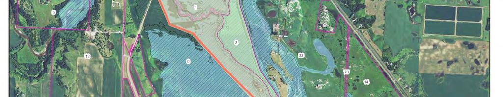
22 Figure 6: NWI Wetlands WHETSTONE RIVER RESTORATION ADDENDUM 20 20
23 4.5 WATER QUALITY Another significant benefit of the project is improving water quality in Big Stone Lake. Big Stone Lake is not currently listed as impaired by the Minnesota Pollution Control Agency (MPCA), but will soon begin the Watershed Restoration and Protection Strategy (WRAPS) process led by the MPCA. The lake has been and continues to be the focus of considerable restoration effort both within Minnesota and South Dakota. This lake is known to have excess nutrients and large algal blooms are common. Accelerated silt deposition in the lower end of Big Stone Lake has been of local interest since the original Big Stone Lake- River project was undertaken in the mid 1930 s. Multiple agencies have proposed plans since that time to improve water quality and flood control on Big Stone Lake, however few have been executed. 3 Since a significant volume of water that is currently entering Big Stone Lake will now flow downstream, sediment and nutrient loads will be reduced and lake water quality will be improved. A water quality analysis was performed to estimate the water quality impacts. During this analysis, all flows below 1,500 cfs were assumed to pass through Big Stone Lake Dam, and not enter the lake. All flow above 1,500 cfs was assumed to enter Big Stone Lake. The load reductions from the various alternatives range from 48% to 94% as seen in Table 6. ALTERNATIVE Table 6: Big Stone Lake Water Quality Impacts - Estimated Annual Load Reductions Average Annual Volume (acrefeet/year) Estimated Average Annual Load Reaching Big Stone Lake from River Total Phosphorus (lbs/yr) Total Suspended Solids (tons/yr) Estimated % Annual Load Reduction From Existing Conditions Total Phosphorus Total Suspended Solids Existing Conditions 6, % 0% Alternative 1 Low Flow / DNR Bankfull Channel Alternative 2 2 Year Compound Channel Alternative 3 5 Year Channel, Riparian Maintenance 3, % 48% 2, % 68% % 94% There is reason for concern about potential downstream water quality impacts, as additional sediment and nutrient loads will be delivered to the Big Stone Lake National Wildlife Refuge and Highway 75 dam. Compared to the other Alternatives, Alternative 2B is better at reducing potential impacts, because the floodplain and channel are laterally connected. With proper design and construction of the historic channel sediment will be deposited on the floodplain, phosphorous attached to sediment will be deposited and sequestered, and dissolved phosphorous will be sequestered through natural channel and floodplain processes. 3 U.S. Army Corps f Engineers, "Water Control Manual, Flood Control - Minnesota River and South Dakota, Highway 75 Dam and Reservoir, Big Stone Lake - River Project," Updated March WHETSTONE RIVER RESTORATION ADDENDUM 21 21
24 5 PRELIMINARY OPINION OF PROBABLE COST Preliminary Opinion of Probable Construction Costs (POPCC) for the restoration alternatives are provided for each alternative in Table 7. The POCCC for Alternative 2B is new, while the estimates for the remaining alternatives were updated based on recent project bidding results. A 20% construction contingency is included in the POPCC, in addition to the land needs, completing a geotechnical investigation, technical support including the preparation of final plans and specifications, construction management, and obtaining necessary permits and approvals. The 20% construction contingency is to account for the fact that final design of the project is yet to occur and potential unforeseen construction circumstances. These circumstances are typically related to soil conditions or other geotechnical concerns and dewatering methods. The contingency is more than typical for this particular project due to the multiple agencies both permitting and reviewing the project, and due to potential design changes that may be necessitated. Table 7 includes the project features shown in Figure 1 considered necessary for the restoration project including the work of either constructing new crossings or modifying existing crossings where the historic channel crosses CR 47 and CSAH 15. Table 7: Preliminary Opinions of Probable Construction and Total Project Costs for the Restoration Project Alternative 1 Low Flow / DNR Bankfull Channel Alternative 2 2 Year Compound Channel Alternative 2B Alternative 2 With Setback Levees and Natural Channel Design Alternative 3 5 Year Channel, Riparian Maintenance RESTORATION Channel Restoration, Levees, and Ring Dike $364,833 $695,833 $1,633,102 $1,909,385 Crossing at SD CR 47 $390,970 $533,969 $792,328 $792,328 Crossing at MN CSAH 15 $471,434 $624, $884,000 Grading and Bituminous MN CSAH 15 NA $809,276 $20,607 $330,172 Diversion Weir on River $259,100 $309,200 $309,200 $1,037,625 Grade Control Weir on Historic Channel $34,135 $41,965 $41,965 $41,965 Construction Right-Of-Way/Easements $11,000 $32,000 $32,000 $140,200 SUBTOTAL Construction Cost $1,531,473 $3,046,244 $2,829,201 $5,135,675 ADMINISTRATION, TECHNICAL AND LEGAL Construction Contingency (20%) $306,295 $609,249 $565,840 $1,027,135 Engineering/Construction Observation (20%) $306,295 $609,249 $565,840 $1,027,135 Geotechnical $25,000 $25,000 $25,000 $25,000 Permitting $25,000 $30,000 $30,000 $40,000 Administrative/Legal (15%) $229,721 $456,937 $424,380 $770,351 SUBTOTAL $892,310 $1,730,434 $1,611,061 $2,889,621 TOTAL Excluding Land $2,423,783 $4,776,678 $4,440,262 $8,025,296 LAND AQUISITION Fee Purchase $268,205 $268,205 $1,030,300 $268,205 Flowage and Work Easements $167,427 $305,552 $123,180 $311,447 SUBTOTAL Land Acquisition $435,631 $573,757 $1,153,480 $579,652 TOTAL PROJECT COST $2,859,414 $5,350,435 $5,593,742 $8,604,947 WHETSTONE RIVER RESTORATION ADDENDUM 22 22
25 There are additional transportation related costs, not included in Table 7, associated with modifying the local transportation system. These items are shown in Table 8. Table 8: Additional Related Transportation System Improvement Costs (Alternative 2B only) Feature Estimated Cost Grade Widening CR 47 / CSAH 15 Connection $780,000 Bituminous Surfacing CR 47 / CSAH 15 Connection $100,000 Existing CSAH 15 Roadway Obliteration/ Reclaiming $80,000 Additional Roadway Connections and Driveways $230,000 TOTAL Transportation Construction $1,190,000 6 PERMITS AND APPROVAL Obtaining permits and approvals is expected to be considerably less of a challenge should the Board of Managers decide to proceed with Alternative 2B, compared to the other alternatives evaluated within the Engineer s Report. The reason is Alternative 2B includes setback levees and open channel design more consistent with a stream restoration project. Obtaining permits for the other alternatives could be similar to Alternative 2B with regard to the probable level of effort, simply by setting the levees back from the historic channel and incorporating a more natural open channel design. However, the larger open channel dimensions of Alternative 3 could prove problematic, as the open channel is considerably larger than needed to carry the DNR bankfull discharge. To achieve channel stability this would potentially require excavating a considerable floodplain bench. This would not necessary prove problematic, depended on the need for material to construct the agricultural levees should they be setback from the channel. Ultimately, this is final design consideration (i.e., balancing the amount of material to construct levees and excavation of a floodplain bench adjacent to the open channel need to convey bankfull discharge). 7 ENGINEER S RECOMENDATION The determination of project feasibility is based upon several design criteria established by the Engineer. These criteria include: The ability to attain the project goals (i.e., consistency with stream restoration project); An understanding of the perceived magnitude of the potential environmental adverse and beneficial impacts and the likelihood of obtaining the necessary regulatory approvals and permits; The perceived constructability of the project; Whether the project is conducive to public health, safety, and welfare; and Probable construction cost. Based upon the information presented in the Engineer s Report and this Addendum, it is the opinion of the Engineer that all four alternatives are feasible and capable of achieving the design goals, but to differing degrees. All of the alternatives will achieve the primary design goal of restoring perennial flow to the historic River channel. However, by setting the levees back from the historic channel, the quality of the restoration is greatly improved. Unacceptable adverse resource impact as a result of this project as a result of an increase in peak discharge and water surface elevation within the refuge are not anticipated. However coordination with the U.S. Army WHETSTONE RIVER RESTORATION ADDENDUM 23 23
26 Corps of Engineers will be needed to discuss whether operational changes at the Highway 75 dam are needed. Downstream adverse impacts because of increased peak discharge are less of a concern with Alternative 2B because of the additional storage located between the setback levees. Alternative 2B is expected to have many beneficial environmental benefits, compared to Alternatives 1, 2, and 3, because these alternatives place the levees adjacent to the historic channel. The benefits of Alternative 2B could be realized for each of these alternatives simply placing the levees in a location similar to Alternative 2B. The open channel dimensions and characteristics of Alternative 3 seem too large for a restoration project. Both capital and maintenance costs can be considered when assessing project feasibility. There was no specific quantitative criterion established related to project cost. Generally, project cost is evaluated relative to other, similar type projects. There is a typically a strong relationship between the constructability of a project and the project cost. Based on the estimated POPCCs the cost for all three alternatives is considered reasonable as the project costs fall within similar type projects. With regard to future maintenance Alternative 2B should require less maintenance than the other alternatives, because on road crossing is eliminated and there is considerable floodplain area for sediment and debris to deposit. Based upon our analysis, alternative 2B is recommended (see Table 9: ). This recommendation is based on the following considerations: Because of the presence of setback levees, the design of alternative 2B is more consistent with a stream restoration project than alternatives 1, 2, or 3. Alternatives 1, 2, and 3 could be modified should the Board desire, to realize the benefits of the setback levees for these alternatives; Compared to alternatives 1, 2, and 3 the potential for adverse and beneficial ecological impacts downstream is significantly reduced and enhanced respectively, because of the setback levees; Based upon the judgment of the Engineer, the cross-sectional area of the open channel for the restored and reconstructed portion of the historic channel for Alternative 2B (and Alternative 2) is more appropriate and consistent with a restoration, than either alternatives 1 and 2. Although the DNR has estimated a bankfull capacity based on geomorphic analysis of the River of a channel cross sectional area similar to Alternative 1, the surveyed cross sectional area of the historic channel in undisturbed areas (see Section 3.2, Figure 2) is more consistent with Alternative 2B (~ 300 ft 2 ). The Engineer believes the capacity of and cross sectional area of Alternative 3 is larger than desired, although it could be designed in a manner to improve geomorphic stability. This is admittedly a design detail to be resolved through discussions with the Department of Natural Resources. However, final design of the channel should be consistent with that of a natural channel as shown in Figure 7; Water quality will improve within Big Stone Lake, because of a reduction in the annual load delivered. An estimate of the load reduction is provided. The reduction in nutrient loads should result in the reduction in the abundance of algae. Even though this load will be now be delivered downstream, restoring the stream channel with connection to the floodplain (for alternative 2B) will ameliorate potential adverse impacts. A large portion of the sediment and phosphorus adhered to sediment is expected to deposit in the floodplain adjacent to the historic restored channel. The absence of setback levees is more likely to result in sedimentation issues associated with the project, including the need for and cost of maintenance. The opinion of the Engineer, is the long term maintenance requirements and costs for Alternative 2B will be less than the other Alternatives, because debris and sediment entering the historic WHETSTONE RIVER RESTORATION ADDENDUM 24 24
27 channel will largely be deposited with the adjacent floodplain area. Additional discussion is needed with the DNR about the design of the River diversion structure and the grade control structure near the inlet to the historic River. The DNR has requested a design similar to Figure 8 for the River structure. The Engineer recommends pursuing this type of design with an embedded sheet pile structure. The Engineer believes the POPCC reflects the construction of both designs. The presence of the setback levees incorporated into Alternative 2B provides greater certainty with regard to the likelihood of flooding of agricultural lands external to the levees; Although reduction in peak flood elevations on Big Stone Lake are a positive consequence of the project, Alternative 2B results in a reasonable reduction compared to the other Alternatives; Perceived potential adverse impacts because of an increase in the peak discharge and peak water surface elevations within the Big Stone Lake National Wildlife Refuge and upstream of the Highway 75 dam are in fact more reflective of historic conditions. Although the peak discharge delivered downstream and therefore the water elevations (assuming Highway 75 dam operation remains unaltered) will increase for each alternative including 2B compared to existing conditions, the volume of water compared to existing conditions for each alternative will not differ. Only a portion of the water will flow through the restored Historic Channel during flood events. Because the volume will remain unchanged it seems reasonable to believe management of any peak discharge can be accomplished through operation of the Highway 75 dam (and perhaps the Big Stone Lake Dam as the analysis assumed no operational change). Additional analyses is needed to evaluate how dam operation at Highway 75 and Big Stone Lake should and can be modified; and It is the opinion of the Engineer that the project is in the public interest. The project can be implemented without reducing public safety and increasing public welfare. There are some potential adverse consequences with alternative 2B. These consequences include: The removal of an estimated 254 tillable acres of land from production; and The additional cost associated with the need to modify the local transportation system (which will improve the system) and acquire land. Should the Board of Managers decide to proceed and order the Engineer s recommended alternative, additional coordination with the agencies should begin as soon as possible. Specifically, discussions with the Department of Natural Resources are needed to finalize design of the historic open channel. Secondly, discussions are needed with the U.S. Fish and Wildlife Service about potential hydrologic changes within the refuge and the U.S. Army Corps of Engineers to discuss operational considerations with the Highway 75 dam. WHETSTONE RIVER RESTORATION ADDENDUM 25 25
28 Table 9: Summary of the River Restoration Alternatives Factor Perennial Flow to Historic Channel Lateral (Floodplain) Connectivity Longitudinal Connectivity Fish Passage Big Stone Water Quality Improvements Downstream Water Quality Big Stone Lake Flooding Reduction Downstream Impacts: Agricultural Downstream Impacts: Highway 75 Dam Transportation Safety Cost Permitting Complexity/Impacts Existing Condition O O O O -- O O O O O Alternative 1: Low Flow / DNR Bankfull Channel Alternative 2: 2 Year Compound Channel Alternative 2B: Alternative 2 with Setback Levees Alternative 3: 5 Year Channel, Riparian Maintenance O O O O O O O O O O Assumes operation of Hwy 75 dam can mitigate downstream impacts. Setback levees is positive. Assumes widening of SD CR 47 improves safety. O = no change from current condition. In some cases, lost opportunity for improving current conditions (e.g., Big Stone Lake) + slight positive benefit ++ moderate positive benefit +++ substantive positive benefit - slight adverse impact -- moderate adverse impact --- substantive positive impact WHETSTONE RIVER RESTORATION ADDENDUM 26 26


29 Figure 7: Natural Channel Design Concept for Upper Portion of Historic River Channel WHETSTONE RIVER RESTORATION ADDENDUM 27 27

30 Figure 8: Concept Design of River Diversion Structure Preferred by Minnesota Department of Natural Resources WHETSTONE RIVER RESTORATION ADDENDUM 28 28