JOINT PUBLIC NOTICE. May 22, United States Army Corps of Engineers State of Louisiana
|
|
|
- Logan Maxwell
- 5 years ago
- Views:
Transcription
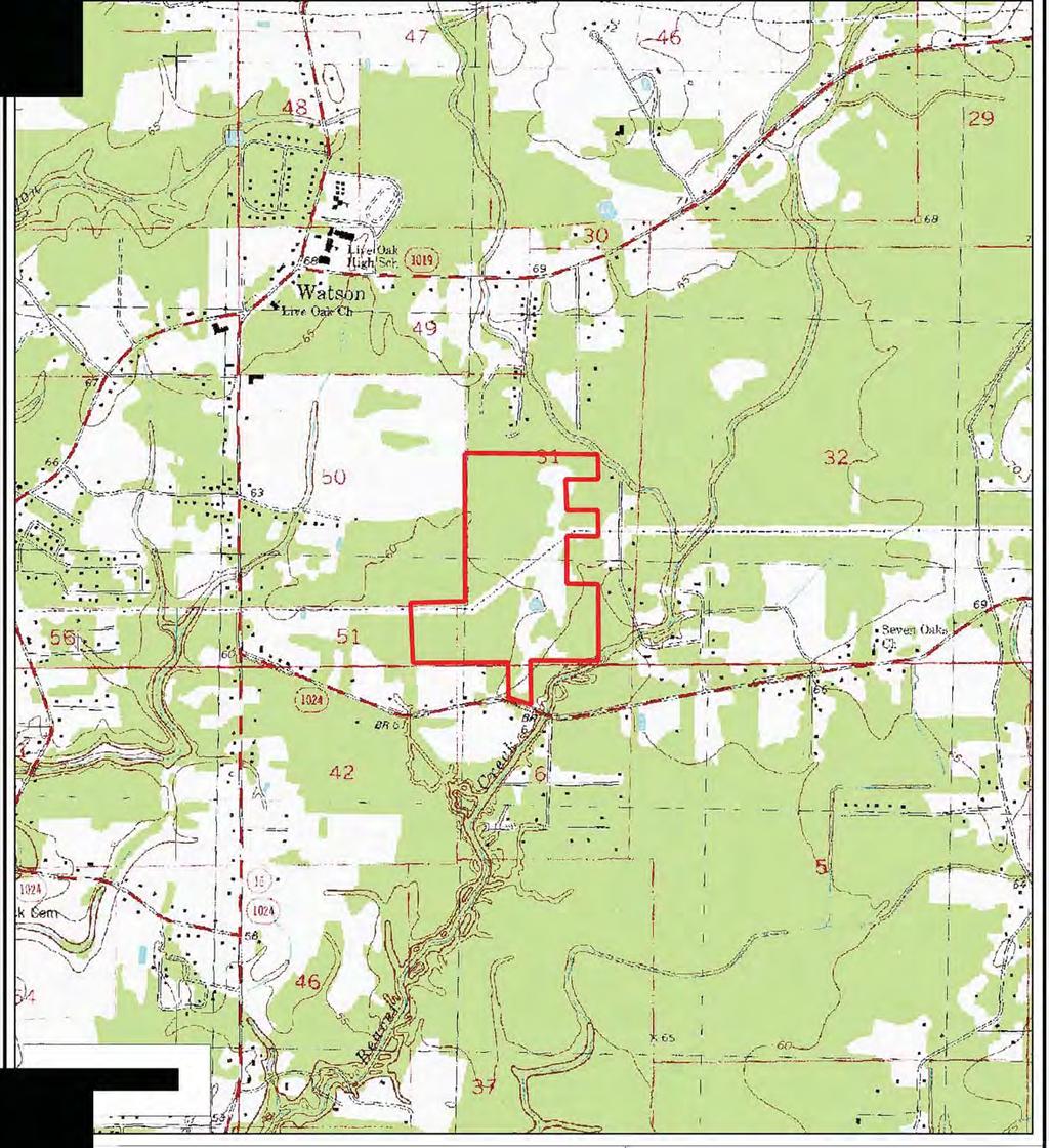
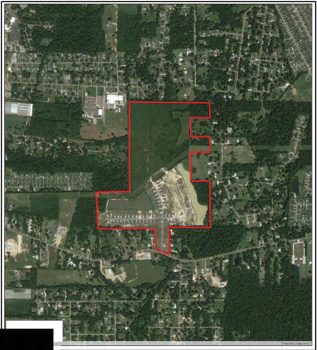
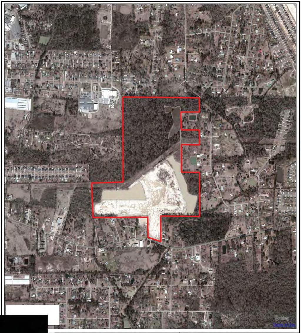
1 JOINT PUBLIC NOTICE May 22, 2017 United States Army Corps of Engineers State of Louisiana New Orleans District Department of Environmental Quality Regulatory Branch Office of Environmental Services Post Office Box Post Office Box 4313 New Orleans, Louisiana Baton Rouge, Louisiana (504) (225) Project Manager Project Manager S. Gail Gainey Elizabeth Hill WQC Application Number MVN CG WQC # Interested parties are hereby notified that a permit application has been received by the New Orleans District of the US Army Corps of Engineers pursuant to: [ ] Section 10 of the Rivers and Harbors Act of March 3, 1899 (30 Stat. 1151; 33 USC 403); and/or [X] Section 404 of the Clean Water Act (86 Stat. 816; 33 USC 1344). Application has also been made to the Louisiana Department of Environmental Quality, Office of Environmental Services, for a Water Quality Certification (WQC) in accordance with statutory authority contained in LRS 30:2074 A(3) and provisions of Section 401 of the Clean Water Act. RESIDENTIAL SUBDIVISION IN LIVINGSTON PARISH NAME OF APPLICANT: D.R. Horton, Gulf Coast, c/o Hydrik, Inc., 2323 Hwy 190 East, STE 2, Hammond, LA LOCATION OF WORK: In Sections 51 and 31, T5S-R3E, near Watson, Louisiana in Livingston Parish, within the Amite River Basin in hydrologic unit (HUC ), as shown on the attached drawings (Latitude N, Longitude W). The work described below was partially completed prior to obtaining a Department of the Army permit and was in violation of Section 301 of the Clean Water Act. All legal issues concerning the unauthorized work have since been deferred. CHARACTER OF WORK: The work described herein was placed on public notice from November 11, 2016 through November 27, 2016 with the exception of the unauthorized clearing and placement of fill material in 0.53 acres of jurisdictional wetlands. Work to construct the 1 st and 2 nd Filing areas has been partially completed under the previous authorization issued to CJS, Inc. on January 10, 2008, extended on October 29, The applicant has procured the property and has requested Department of the Army authorization to modify a reconfiguration and complete the project to include clearing, grading, excavating and depositing fill and/or aggregate material to construct and maintain a residential subdivision (Audubon Lake Subdivision) including roads, ponds, housepads, driveways, utilities and drainage infrastructure for a total of 189 lots. Approximately 7,000 cubic yards of silt fill, 900 cubic yards of concrete and 200 cubic yards of asphalt would be hauled in and deposited to
2 achieve required grade elevation requirements. The proposed project is situated on an approximately 124-acre tract. It has been determined that the proposed project would impact approximately 4.37 acres of wetlands and 1.35 acres of waters of the U.S. 2 It is presumed that the applicant has designed the project to avoid and minimize direct and secondary adverse impacts to the maximum extent practicable. Any further reduction would limit usage of the property and therefore function, deeming the project impracticable. Previous compensatory mitigation required of CJS, Inc. for the original project has been assessed, collected and is considered to be satisfactory for the reconfiguration and remainder of work to be completed. The comment period for the Department of Army will close in 20 days from the date of this joint public notice. Written comments, including suggestions for modifications or objections to the proposed work, stating reasons thereof, are being solicited from anyone having interest in this permit and/or this WQC request and must be mailed so as to be received before or by the last day of the comment period. Letters concerning the Corps of Engineers permit application must reference the applicant's name and the Permit Application Number, and be mailed to the Corps of Engineers at the address above, ATTENTION: REGULATORY BRANCH. Similar letters concerning the Water Quality Certification must reference the applicant's name and the WQC application number and be mailed to the Louisiana Department of Environmental Quality at the address above. Individuals or parties may request an extension of time in which to comment on the proposed work by writing or ing the Corps of Engineers Project Manager listed above. Any request must be specific and substantively supportive of the requested extension, and received by this office prior to the end of the initial comment period. The Section Chief will review the request and the requestor will be promptly notified of the decision to grant or deny the request. If granted, the time extension will be continuous to the initial comment period and, inclusive of the initial comment period, will not exceed a total of 30 calendar days. The application for this proposed project is on file with the Louisiana Department of Environmental Quality and may be examined during weekdays between 8:00 a.m. and 4:30 p.m. Copies may be obtained upon payment of costs of reproduction. Corps of Engineers Permit Criteria The decision whether to issue a permit will be based on an evaluation of the probable impacts, including cumulative impacts of the proposed activity on the public interest. That decision will reflect the national concern for both protection and utilization of important resources. The benefit which reasonably may be expected to accrue from the proposal must be balanced against its reasonably foreseeable detriments. All factors which may be relevant to the proposal will be considered including the cumulative effects thereof; among those are conservation, economics, aesthetics, general environmental concerns, wetlands, historic properties, fish and wildlife values, flood hazards, floodplain values, land use, navigation, shoreline erosion and accretion, recreation, water supply and conservation, water quality, energy needs, safety, food and fiber production, mineral needs, considerations of property ownership and, in general, the needs and welfare of the people. The US Army Corps of Engineers is soliciting comments from the public, federal, state, and local agencies and officials, Indian Tribes, and other interested parties in order to consider and evaluate the impacts of this proposed activity. Any comments received will be considered by the US Army Corps of Engineers to determine whether to make, modify, condition, or deny a
3 3 permit for this proposal. To make this decision, comments are used to assess impacts on endangered species, historic properties, water quality, general environmental effects, and other public interest factors listed above. Comments are used in the preparation of an Environmental Assessment and/or an Environmental Impact Statement pursuant to the National Environmental Policy Act. Comments are also used to determine the need for a public hearing and to determine the overall public interest of the proposed activity. The New Orleans District is unaware of properties listed on the National Register of Historic Places near the proposed work. The possibility exists that the proposed work may damage or destroy presently unknown archeological, scientific, prehistorical, historical sites, or data. Copies of this notice are being sent to the State Archeologist and the State Historic Preservation Officer. Our initial finding is that the proposed work would neither affect any species listed as endangered by the U.S. Departments of Interior or Commerce, nor affect any habitat designated as critical to the survival and recovery of any endangered species. Utilizing Standard Local Operating Procedure for Endangered Species in Louisiana (SLOPES), dated October 22, 2014, between the U.S. Army Corps of Engineers, New Orleans and U.S. Fish and Wildlife Service, Ecological Services Office, the Corps has determined that the proposed activity would have no effect on any listed species. This notice initiates the Essential Fish Habitat (EFH) consultation requirements of the Magnuson-Stevens Fishery Conservation and Management Act. The applicant's proposal would result in the destruction or alteration of up to n/a acres of EFH utilized by various life stages of red drum and penaeid shrimp. Our initial determination is that the proposed action would not have a substantial adverse impact on EFH or federally managed fisheries in the Gulf of Mexico. Our final determination relative to project impacts and the need for mitigation measures is subject to review by and coordination with the National Marine Fisheries Service. If the proposed work involves deposits of dredged or fill material into navigable waters, the evaluation of the probable impacts will include the application of guidelines established by the Administrator of the Environmental Protection Agency. Also, a certification that the proposed activity will not violate water quality standards will be required from the Department of Environmental Quality, Office of Environmental Services before a permit is issued. Any person may request, in writing, within the comment period specified in this notice, that a public hearing be held to consider this application. Requests for public hearings shall state, with particularity, the reasons for holding a public hearing. You are requested to communicate the information contained in this notice to any other parties whom you deem likely to have interest in the matter. Enclosures for JOHN M. HERMAN Chief, Central Evaluation Section Regulatory Branch
4 R2E R3E LIVE OAK HIGH SCHOOL LIVE OAK PRESCHOOL 16 Creek River Amite Clayton Bayou WATSON LIVE OAK Beaver SOUTH OAK ELEM. LIVE OAK MIDDLE SCHOOL SPRINGFIELD SANDPIPER 1024 Creek OSPREY KINGFISHER 6 HWY CANE 1019 SITE MARKET Moler LIVINGSTON PARISH T5S T6S PERKINS Bayou 3 AMITE CHRISTIAN SCHOOL AMITE CHURCH TO DENHAM SPRINGS Beaver 37 PLAINVIEW ARNOLD Colton Creek LINDER 8 C LINTON ALLEN ARNOLD DUNN PERKINS 1025 Colyell Creek BURGESS 24 RIVER '38 N, 90 56'42 W West 22
5
6
7
8
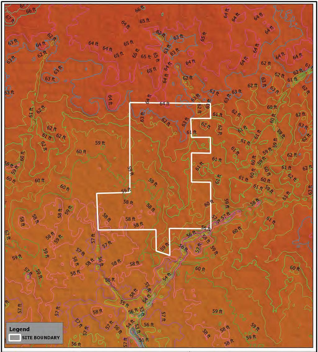
9 19 SEC. 50 SEC. 51 C43 3rd 100' 100' 84.64' C6 4th OSPREY C5 C ' ' 82.6' 100' 100' 72.27' ' ' ' ' ' ' 152.9' 421' 593' ' ' 1025' 389' 348' NOTE: THIS SITE IS LOCATED IN FLOOD S AE & B PER F.I.R.M. PANEL NO.'s 22063C0115 D & 22063C0150 D DATED 8/23/01. BASE FLOOD ELEV. = 59.0' to 64' SEC. 50 SEC. 51 SEC. 42 WETLANDS TO BE EXCAVATED Sq.Ft. c/o CALVIN BLOUNT 9330 PECUE LANE BATON ROUGE, LA ' ENTERGY 1st PERMITTED AS FILLED NOTE: BASE DRAWINGS PROVIDED BY: ALVIN FAIRBURN & ASSOCIATES, LLC DENHAM SPRINGS, LA SEC. 6 SEC ' 61' SEC ' R/W 64' KINGFISHER LA HWY 1024 CANE MARKET PERMITTED AS FILLED AREA SANDPIPER TATLER 2nd 1st KINGFISHER OSPREY PERMITTED AS FILLED Drainage OTHER WATERS OF THE U.S. DATA TOTAL OTHER WATERS Ac TO BE FILLED Ac TO BE EXCAVATED Ac NOT TO BE IMPACTED Ac TO BE RELOCATED Ac SEC. 31 T5S-R3E SEC. 51 T6S-R3E 50' DRAINAGE R/W N02 38'14W 85' 9' UNAUTHORIZED ACTIVITY DETAIL 'A-A' N.T.S. NOTE: ALL CONSTRUCTION WITHIN 1ST & 2ND AREAS PERFORMED BY AUDUBON LAKES, LLC 53.58' ' 79.42' ' ' 21 Relocated Other Waters of the U.S. (2,904 LIN. FT.) DETENTION LAKE 3 PROPOSED AC. N.W.S.=58' TRANSMISSION EXISTING DETENTION LAKE AC. N.W.S.=58' AE LINE X ' X AE ' 7.88 AC. N.W.S. = 58' AE X AREA X X AE AE 183 BEAVER ' 42.79' C ' ' ' ' C10 C ' C11 C ' 750' ' ' ' ' 52.24'80.03' 80.03' A AREA OF UNAUTHORIZED ACTIVITY BY AUDUBON LAKES, LLC 30 33'47 N 90 56'43 W PRESERVED AREA UNDER EXPIRED PERMIT TO REMAIN PRESERVED 0.70 Ac. DETAIL 'A-A' 0.53 Ac. TOTAL NUMBER OF PROPOSED RESIDENTIAL LOTS = ' ' 59.2' ' 20.83' N00 21'46W ' ' ' ' 80.05' 80.05' 1305' ' 94.14' ' ' ' ' ' ' C40 C ' ' ' 37' C ' C39 50' ' ' C53 C54 C45 C38 C ' 60.33' 90' C55 36' ' ' 55.81' 24.23' C46 C ' C49 C ' C51 C47 C ' 44.53' LS-2 C ' ' ' C ' 7 C C ' ' 9.8' 57.17' 81.6' 17.35' N89 42'06E 82.47' 15' 54.32' 60.33' 52.85' 150' 25.18' 25.07' 88.23' 150' 26.08' 81.6' ' ' ' ' DP ' 17.35' ' ' 466' B B 72.39' ' 29.04' 28.93' C ' ' 98.66' C28 C57 C1 C59 C ' 48.47' 41.13' ' 79.87' ' 21.08' 63.63' ' ' ' ' 13.74' 130.8' 130.3' ' ' 35' 35.07' ' ' ' ' C ' 72.78' C2 C29 25' 42.5' 31.34' ' 53.78' 76.21' 97.54' ' ' ' ' ' 89.83' C63 150' 150' 100' 85.56' 10.64' ' 40.97' 321' ALL WETLANDS & WATERWAYS PROPOSED FOR IMPACT WERE ORIGINALLY PERMITTED & MITIGATED UNDER EXPIRED PERMIT MVN CT. CURRENT EXTENSION REQUEST INCLUDES A SLIGHT DESIGN MODIFICATION COMPARED TO THE PREVIOUS PERMIT BUT NO ADDITIONAL JURISDICTIONAL IMPACTS '38 N 90 56'42 W LIVE OAK SCHOOL 30 34'07 N 90 56'45 W 30 33'47 N 90 56'45 W GRAVESBRIAR SUBD '47 N 90 56'43 W N00 09'48W 30 33'38 N, 90 56'42 W C61 C62 PROPOSED DETENTION LAKE ' 93.64' ' 127.6' ' ' ' C ' 69.59' ' 91.34' ' ' 46.85' 100' 92.36' 63.17' 9.42' C ' 87.83' ' 72.18' 34.51' ' ' ' ' ' ' ' ' ' ' 60' 9.42' ' 1823' C25 C ' nd ' C31 C ' 98.41' 52.19' 20' 104' LS ' ' 606' N71 03'24W S00 27'37W DP-5 85' 4.63' ' 85.16' 12.36' 23.56' ' 59.4' 90' 98.48' 94.58' 4.62' C ' C ' ' ' ' 88.39' 31.01' ' ' ' C16 C19 C ' 99' 63.18' ' 88.8' C ' 54.38' C24 C21 25' CREEK 64' ' 95.13' 172 C EXISTING DETENTION LAKE AC. N.W.S.=58' C ' 94.58' 94.58' C ' C37 C36 C ' ' 80.79' 130' ' 174' 174' 94.59' 94.59' ' 74.9' ' A N89 42'46W 30 33'34 N 90 56'35 W HWY R/W LINE 434' 430' 433' 62' ENTERGY TRANSMISSION LINE 150' R/W Unimproved Road (runs between the Other Waters of the U.S.) Relocated Other Waters of the U.S. (22 LIN. FT.) 430' PRESERVED UNDER EXPIRED PERMIT TO REMAIN PRESERVED 2.96 Ac. 921' S00 13'53E 30 34'07 N 90 56'24 W PRESERVED UNDER EXPIRED PERMIT TO REMAIN PRESERVED 30 33'39 N 90 56'24 W SEC Ac. LEGEND 1 OTHER WATERS OF THE U.S. NOT TO BE IMPACTED (0.65 AC) RELOCATED OTHER WATERS OF THE U.S. (TOTAL - 3,126 LINEAR FT.) DELINEATION FLOOD TRANSITION ELEVATION / LINE EXISTING ROADWAY LEGEND 2 OTHER WATERS OF THE U.S. FILLED / EXCAVATED POND AREA PERMITTED FILLED AC. MINOR DRAIN - TO BE POND AREA FILLED - ORIGINALLY PERMITTED FILLED & GRADED FOR EXCAVATION AC. MINOR DRAIN - FILLED PRIOR TO EXP. OF PERMIT MINOR DRAIN - TO BE TO BE EXCAVATED MINOR DRAIN - EXCAVATED PRIOR TO EXP. OF PERMIT FOR DETENTION POND 200' 0' 400' WETLANDS LEGEND: WETLANDS IMPACTED VIA FILL & GRADING 2.90 AC. WETLANDS IMPACTED VIA EXCAVATION 0.94 AC. WETLANDS AVOIDED 6.52 AC. UNAUTHORIZED ACTIVITY IN WETLANDS BY AUDUBON LAKES, LLC 0.53 AC. REV REV REV Ac 1.74 Ac HYDRIK Wetlands - GIS - Flood Control (985)
10 19 SEC. 50 SEC. 51 C6 C5 C4 421' 593' 1025' 389' 348' LIVE OAK SCHOOL WORK PERFORMED PRIOR TO EXPIRATION OF CURRENT PERMIT N00 21'46W GRAVESBRIAR SUBD '07 N 90 56'45 W 30 34'07 N 90 56'24 W 1823' FUTURE S BY D.R. HORTON, INC. NUMBER OF PROPOSED RESIDENTIAL LOTS = ' 434' Drainage NOTE: ALL CONSTRUCTION WITHIN 1ST & 2ND AREAS PERFORMED BY AUDUBON LAKES, LLC AREA OF UNAUTHORIZED ACTIVITY BY AUDUBON LAKES, LLC c/o CALVIN BLOUNT 9330 PECUE LANE BATON ROUGE, LA SEC. 50 SEC '47 N 90 56'43 W PRESERVED AREA UNDER EXPIRED PERMIT TO REMAIN PRESERVED 0.70 Ac. SEC. 42 ENTERGY PERMITTED AS FILLED TOTAL NUMBER OF RESIDENTIAL LOTS COMPLETED TO-DATE = 94 AREA OF S 1 & 2 = AC AREA OF S 3 & 4 = AC TOTAL DEVELOPMENT = AC NOTE: BASE DRAWINGS PROVIDED BY: ALVIN FAIRBURN & ASSOCIATES, LLC DENHAM SPRINGS, LA SEC. 6 SEC. 42 SEC ' R/W 1st 1st LA HWY 1024 CANE MARKET LIMITS OF CONSTRUCTION LINE PERMITTED AS FILLED SANDPIPER KINGFISHER OSPREY PERMITTED AS FILLED SEC. 31 T5S-R3E SEC. 51 T6S-R3E 50' DRAINAGE R/W 806' N02 38'14W 53.58' ' 79.42' ' ' ' C9 C10 C8 C11 C7 EXISTING TRANSMISSION DETENTION LAKE AC. N.W.S.=58' ' 40.39' 79.67' ' 0.53 Ac ' ' ' 57.65' 750' ' ' ' ' 52.24'80.03' 80.03' ' ' 59.2' ' 20.83' ' ' ' ' 80.05' 80.05' 1305' ' ' ' ' ' ' ' 55.81' 24.23' ' ' DP ' 44.53' C ' ' 25.18' 25.07' ' C ' 466' 3 & 4 AREA = 62.8 ACRES 49.32' ' 72.39' 2nd AREA AREA C56 C ' ' 1 C ' C57 C1 C59 C ' 48.47' 41.13' ' 79.87' 26.08' 28.93' ' 21.08' 63.63' ' ' ' ' 13.74' 130.8' 130.3' ' 42.5' 31.34' ' 53.78' ' 35' 35.07' ' ' ' ' C ' 72.78' C ' 85.56' 10.64' ' 321' ALL WETLANDS & WATERWAYS PROPOSED FOR IMPACT WERE ORIGINALLY PERMITTED & MITIGATED UNDER EXPIRED PERMIT MVN CT. CURRENT EXTENSION REQUEST INCLUDES A SLIGHT DESIGN MODIFICATION COMPARED TO THE PREVIOUS PERMIT BUT NO ADDITIONAL JURISDICTIONAL IMPACTS '38 N 90 56'42 W 30 33'47 N 90 56'45 W 30 33'47 N 90 56'43 W N00 09'48W 40.97' 97.54' ' ' ' ' ' 89.83' C61 C ' 93.64' ' ' ' ' ' C ' 69.59' ' 91.34' ' ' 46.85' C ' 93.64' 87.83' ' ' 72.18' 34.51' ' ' ' ' ' ' ' ' 9.42' N71 03'24W 30 33'38 N, 90 56'42 W 68.89' C ' 98.41' 52.19' S00 27'37W 606' LS ' ' BEAVER 2nd ' 88.39' 31.01' ' 200' 0' 400' 59.4' ' C ' C16 C19 C ' C ' ' 54.38' C24 C21 25' N89 42'46W 30 33'34 N 90 56'35 W HWY R/W CREEK LINE C23 C22 430' EXISTING DETENTION LAKE AC. N.W.S.=58' ENTERGY TRANSMISSION LINE 150' R/W PRESERVED UNDER EXPIRED PERMIT TO REMAIN PRESERVED Relocated Other Waters of the U.S. (22 LIN. FT.) 430' 921' S00 13'53E PRESERVED UNDER EXPIRED PERMIT TO REMAIN PRESERVED 2.86 Ac '39 N 90 56'24 W SEC. 6 LEGEND 2 OTHER WATERS OF THE U.S. NOT TO BE IMPACTED RELOCATED OTHER WATERS OF THE U.S. (TOTAL - 1,107 LINEAR FT.) DELINEATION DEVELOPMENT BOUNDARY EXISTING ROADWAY LEGEND 3 OTHER WATERS OF THE U.S. FILLED / EXCAVATED POND AREA PERMITTED FILLED AC. POND AREA FILLED - ORIGINALLY PERMITTED FOR EXCAVATION AC. MINOR DRAIN - FILLED PRIOR TO EXP. OF PERMIT MINOR DRAIN - EXCAVATED PRIOR TO EXP. OF PERMIT HYDRIK Wetlands - GIS - Flood Control (985) WETLANDS LEGEND: WETLANDS IMPACTED VIA FILL & GRADING 2.90 AC. WETLANDS IMPACTED VIA EXCAVATION 0.94 AC. WETLANDS AVOIDED 6.52 AC. UNAUTHORIZED ACTIVITY IN WETLANDS BY AUDUBON LAKES, LLC 0.53 AC. REV REV REV Ac 1.74 Ac
11

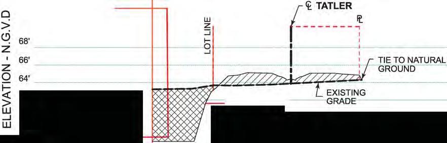
12 TYPICAL STREET SECTION EXISTING U.S. ARMY CORPS OF ENGINEERS JURISDICTIONAL DETERMINATION ACCOUNT NO. MVN SU