Song Lake Water Budget
|
|
|
- Dennis Isaac Cobb
- 5 years ago
- Views:
Transcription
1 Song Lake Water Budget Song Lake is located in northern Cortland County. It is a relatively small lake, with a surface area of about 115 acres, and an average depth of about 14 feet. Its maximum depth is about 30 feet. Song is a seepage lake, having no natural surface inlets or outlets. Groundwater inflow and direct precipitation are the main sources of water to the lake. Overland runoff from areas immediately surrounding the lake are a relatively small source of water. Water outflow from the lake occurs as evaporation and losses to groundwater. SWCD developed a water budget in order to quantify the inflows and outflows, provide a better understanding of lake dynamics, and to ultimately help better understand water quality issues. 1. Song Lake Water Budget Model Groundwater plays a large role in the Song Lake water budget, and its impact on the lake varies seasonally. Because of this, our water budget evaluates seasonal changes, and not just a long-term annual average. The water budget includes: Precipitation (P) directly onto the lake surface Evaporation (E) from the lake surface Surface runoff (R) overland flow into the lake Groundwater (G) the net groundwater flow into or out of the lake The general water budget equation used for Song Lake is: ΔS = P E + R ± G (where ΔS is the change in storage, or change in volume of water) ΔS changes as the lake rises or falls. If the lake level rises over a period of time, ΔS is positive. If it falls over a different period of time, ΔS is negative. In a typical year Song Lake experiences a period of generally rising lake levels (winter and spring), and a period of generally falling levels (summer and fall). We developed an excel spreadsheet to calculate a daily water budget for a typical year, using available long-term average data for precipitation, evaporation, and runoff. For the net groundwater component, we used data from a USGS study to develop a typical seasonal pattern of net inflow or net outflow. These water budget components are described in the following sections.

2 1.1 Precipitation and Evaporation The water budget assumes an annual average precipitation of 42 inches and annual average lake evaporation of 28 inches, distributed as shown in this table. We developed average daily precipitation and evaporation values from the monthly data for input to the water budget spreadsheet. In the spreadsheet model, the volume of water added to the lake from precipitation, or lost from evaporation, is determined by the surface area of the lake on that day, which varies with lake level. 1.2 Surface Runoff Daily Runoff as a Percent of Total Annual Runoff While the lake has no surface inlet or 1.0% outlet, it receives some overland runoff 0.9% from the immediately surrounding land area. From topography, we estimated this land area to be about 62 acres. Soils in the area are quite permeable, and much of the precipitation infiltrates rather than flowing overland. We estimated that just 6 of the 42 inches of annual precipitation flows overland to the lake. In the 0.8% 0.7% 0.6% 0.5% 0.4% 0.3% 0.2% 0.1% 0.0% spreadsheet model, daily runoff for the 1-Jan different seasons was determined based 1-Feb 1-Mar 1-Apr 1-May 1-Jun 1-Jul 1-Aug 1-Sep 1-Oct 1-Nov 1-Dec on the runoff characteristics for the USGS streamflow gage for the Tioughnioga River at Cortland. The most runoff occurs in the spring, and the least in late summer. 1.3 Groundwater From 1998 to 2001, Bill Kappel and Todd Miller of USGS investigated water levels in the kettlelakes region of northern Cortland and southern Onondaga counties, including Song Lake. They measured lake and groundwater levels, which provided a good starting point for understanding how groundwater interacts with the lake. Based on the USGS data, we believe the southeast part of the lake nearly always loses water to


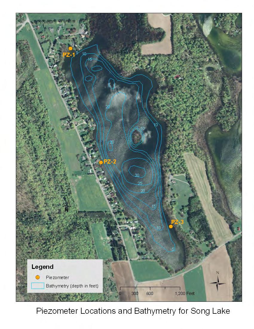
3 groundwater. In the northwest, groundwater flows into the lake for much of the year. Between these two areas, groundwater interaction varies seasonally. There are times of the year when the entire lake is losing water to groundwater. There appear to be occasional short periods when the entire lake is gaining groundwater. To better understand groundwater interaction, we installed three piezometers in the lake in 2010 (a map with piezometer locations is included in Appendix A). The piezometers are essentially mini-wells that were driven through the bottom sediments, and into the underlying sand and gravel aquifer. Our piezometer investigation confirmed the USGS findings. During our investigation we always measured a difference in water level between the lake and a piezometer, as seen in the adjacent graphic. Difference in Water Level (feet) Lake and Piezometer Water Level Differences PZ-1 PZ-2 PZ-3 Lake -3 9/1/10 12/1/10 3/2/11 6/1/11 8/31/11 11/30/11 A difference in water level indicates a pressure difference that drives flow. If the lake level is higher, water flows from the lake to groundwater through the bottom sediments. If it is lower, groundwater flows into the lake through the bottom sediments. In the adjacent schematic, the lake level is higher than groundwater, and so the lake loses water to groundwater. When the groundwater level is higher than the lake, it is a condition that is similar to an artesian well. In the case of Song Lake, rising groundwater levels to the west, combined with the low permeability bottom sediments, cause groundwater pressure beneath the lake, resulting in a water level in the piezometer that is higher than the lake level. The difference in lake level and groundwater level largely occurs because the bottom sediments are of lower permeability than the underlying sand and gravel aquifer. When the lake level is higher than groundwater, the lake loses water. But flow through the bottom sediments is relatively slow, so the lake drops slowly but remains perched above groundwater. And when groundwater is higher, the groundwater inflow rate is relatively slow, and it takes time for the lake to rise. Given time, the lake and groundwater levels could reach equilibrium, but the constantly changing hydrologic conditions combine to prevent this from happening very often.
4 Groundwater is by far the water budget component with the most uncertainty, and its role in the water budget is difficult to quantify. The problem is related to the fact that groundwater inflow and outflow occur at the same time. This means that a mathematically consistent water budget could be derived using a high groundwater inflow/outflow rate, or a low one. An accurate understanding of groundwater inflow/outflow is important for determining the relative size of the inputs to the lake. It is also important for determining an accurate hydraulic residence time (also called flushing rate). The flushing rate is an estimate of the amount of time water resides in the lake, and has implications for water quality. We used a carefully selected subset of the USGS data to help quantify groundwater inflow/outflow rates. This involved calculating the hydraulic conductivity (K) of the bottom sediments, which is a measure of how readily water flows through a porous medium. To estimate K, we selected a time period when: 1. There was little to no precipitation, 2. There was little to no lake evaporation, and 3. The groundwater level was lower than the lake level over the entire lake, meaning there was no groundwater inflow. This allowed us to ignore all water budget components but groundwater outflow (and small amounts of evaporation were assumed to occur). During this period there was no inflow to the lake, and nearly all outflow was to groundwater. The period selected was October 19-26, During this time the lake dropped about 0.25 inches per day. Using Darcy s equation we were able to approximate the K value of the bottom sediments. Additional information on this approach is provided in Appendix A. With a better understanding of flow through the bottom sediments, we used the USGS data to develop an expected pattern of the net groundwater inputs to the lake over the course of a typical year. We then incorporated this into the spreadsheet model. 1.4 Water Budget Model Our water budget model calculates daily changes in lake level resulting from a change in lake volume (net inflow or outflow from P, E, R and G). The surface area and volume of the lake change as the lake level changes, and this affects the water budget. So we developed curves that relate the lake elevation to its surface area, and to its storage volume. The curves are used to determine how precipitation and evaporation affect the lake volume as the lake level rises or falls. They also are used to determine how the lake level changes in response to a change in volume. These curves are shown in Appendix A. The model starts with an assumed lake level for the first day of the year. The starting lake level is the average January 1 level from the USGS data. For each succeeding day, net inflow/outflow volume is calculated, and a new lake level is determined using the elevation-volume rating curve. This continues for 365 days.
5 The model was calibrated by matching the final lake level with the starting level, so that ΔS from the water budget equation is equal to zero. We also calibrated the model by comparing the simulated lake levels to the measured USGS data. We modified groundwater inflow/outflow to calibrate the model, which is the presumed input with the most uncertainty. We believe that this technique has resulted in a reasonably good estimate of the seasonal quantity of groundwater that enters the lake, and the seasonal quantity of water lost from the lake to groundwater. The graphic below shows the model results compared to the USGS data. In this graph, the 1998, 1999, 2000 and 2001 lines represent the data collected by USGS. The dashed red line is an average of the USGS data. The blue line represents the results of our calibrated model. The spiky nature of the USGS data reflects large rain or snowmelt events, and the general variability in hydrology and weather in any given year. The model does not incorporate this type of variability. Figure 1 is a conceptual representation of the various water budget components for Song Lake during the summer and fall, when the lake level is generally declining. Figure 2 is a conceptual representation of the water budget components for Song Lake during the winter and spring, when the lake level is generally rising.

6 Figure 1. Conceptual Model of Song Lake Water Budget Summer / Fall Groundwater Table Lake evaporation increases, and is greater than precipitation in some months. There is less overland runoff from the area immediately surrounding the lake. Regionally, infiltration to groundwater decreases, largely because of evapotranspiration. The groundwater table generally drops below the lake level across the entire lake, and it loses large amounts of water to groundwater. Groundwater inflow may occur occasionally in response to a large rain event, but lasts a short time.. The net effect is that the lake level typically drops about 3 to 4 feet between May and October/November.

7 Figure 2. Conceptual Model of Song Lake Water Budget Winter / Spring Groundwater Table Evaporation from the lake decreases to near zero. Infiltration to groundwater increases due to snowmelt and decreased evapotranspiration Groundwater flows into the lake from the west because the groundwater has risen above the lake level. The lake continues to lose water to the aquifer to the south and east, because groundwater remains below the lake level. There is increased runoff to the lake from the land immediately surrounding the lake. The net effect is that the lake level typically rises about 3 to 4 feet between December and May.
8 2. Water Budget Findings Figure 3 shows inflows and outflows for Song Lake in a typical year, as a percent of volume. Direct precipitation and groundwater inflow are the largest water sources, with each making up about half the total inflow. Overland runoff is a relatively small part of the water budget. Losses to groundwater make up about 2/3 of total outflow, with evaporation accounting for the other third. Figure 3. Water Budget for Song Lake Direct Precip 51% Runoff 4% Evaporation 34% INFLOWS Groundwater Inflow 45% OUTFLOWS Groundwater Outflow 66% Figure 4 shows the typical monthly distribution of inflows and outflows for Song Lake. Precipitaion is distributed fairly evenly throughout the year, while evaporation is largely confined to the warmer months. The groundwater Figure 4. Monthly Distribution of Water Budget Components values in Figure represent net groundwater inflow 100 or outflow. During the winter and spring 50 there is generally a net inflow of groundwater to the 0 lake. For the rest of the year, there is -50 generally a net loss from the lake to -100 groundwater. Inflow or Outflow Volume (acre-feet) -150 Jan Feb Mar Apr May Jun Jul Aug Sep Oct Nov Dec Evaopration Direct Precip Runoff Net Groundwater
9 The adjacent table presents information on how Song Lake changes in a typical year. The lake level typically rises and falls about 3 to 4 feet each year. Surface area averages about 115 acres, but can decrease or increase by about 3 acres seasonally. On average, the lake volume is a little over 500 million gallons. 2.1 Inflow Rates On a long-term average basis, direct precipitation onto the lake contributes about 360,000 gallons per day (gpd). Our model indicates that annual average groundwater inflow is about 330,000 gpd. From a mass-balance perspective this makes sense, given the available groundwater recharge area. With runoff added, the total average inflow to the lake is on the order of about 700,000 gpd. During the winter and spring, when the lake is rising, the groundwater inflow rates are much higher than the annual average. We estimate that total inflow rates in the spring can be on the order of 1.5 million gallons per day (MGD), and that groundwater inflow can be 1 MGD or more. In the summer and fall, relatively little runoff and groundwater inflow occurs, and probably only in response to larger rain events. Most inflow during this period is from direct precipitation onto the lake. 2.2 Outflow Rates Evaporation losses from Song Lake average about 240,000 gpd over a year, but the rates are close to zero in the winter, and are likely well over 500,000 gpd in the heat of summer. Losses to groundwater, on a long-term average basis, are estimated to be about 460,000 gpd. They are probably less in the winter and spring, when a smaller area of the lake is losing water. 2.2 Hydraulic Residence Time The hydraulic residence time (HRT), is the average amount of time water resides in the lake. HRT can be estimated by simply dividing the lake volume by the long-term average inflow/outflow rate. For Song Lake: HRT = 522 million gallons / 700,000 gpd = 746 days, or about 2 years This equation assumes that the lake is well-mixed (rather than stratified), and that there are no preferential flow paths that result in stagnant areas. If either of these conditions is present in a lake, different zones could have much longer or shorter residence times than the average. Song Lake appears to be fairly well mixed compared to many lakes. Our sense is that the 2-year HRT is fairly realistic for Song Lake.
10 Appendix A
11
12 NORTHWEST SOUTHEAST NORTHWEST SOUTHEAST Lake Surface Lake Surface Groundwater Groundwater Song Lake Low Groundwater Condition Song Lake High Groundwater Condition as Measured by USGS October 26, 2000 as Measured by USGS Aprilr 26, 2000 Song Lake Surface Elevation and Groundwater Elevations from the USGS Kettle Lakes Study
13 USGS Data Used to Estimate Hydraulic Conductivity (K) of the the Bottom Sediments of Song Lake
14 Estimating Hydraulic Conductivity (K) to Determine Vertical Flow into or out of Song Lake Vertical flow between a surface water and groundwater is governed by the thickness and permeability of the stream or lake bed deposits, and the elevation difference between the surface water and groundwater. Vertical flow through the lake bed can be determined using Darcy's equation: Q = Kv * i * A Q = vertical flow rate (in cubic feet per day or ft3/d) Kv = vertical hydraulic conductivity of the lake bed deposits i = vertical hydraulic gradient across the lake bed deposits (ft/ft) A = surface are of the water body (ft2) and i = (Hs - Hg) / T Hs = Elevation of the surface water (ft) Hg = Elevation of groundwater (ft) T = thickness of the lake bed deposits (ft) A unit flow rate (Qu) can be determined by eliminating the area term (A). Qu = Kv * i Vertical Hydraulic Conductivity (Kv) Rearranging the unit flow equation: Kv = Qu / i The units for Qu are ft/day The key to quantifying groundwater influence on Song Lake is to estimate the vertical conductivity (Kv) of the lake bed deposits. Kv values in general have a very large range, and Kv likely varies across the lake. But we can estimate an average, lake-wide Kv value from USGS data. We can determine an overall average Qu from USGS lake level data for Song Lake for the period October 19-31, During this time, there was no precipitation, little evaporation, and the groundwater level was below the lake level over the entire lake. Over this time, the lake dropped approximately 0.25 inches per day. Qu = 0.25 or in/day ft/d Assume 0.05 inches per day of evaporation Revised Qu = ft/d to account for evaporation Hs = ft from USGS study Hg = 1190 ft average across the lake, from USGS study T = 8 ft average for lake based on recent piezometer installation Kv = fpd USE 0.1 fpd or 3.5 * 10-5 cm/sec
15 1200 Surface Area (acres) Elevation in Feet above MSL Volume Surface Area Lake Volume (acre-feet) Song Lake Elevation versus Surface Area and Volume