LOCATION RESTRICTIONS - WETLANDS BASIN 6
|
|
|
- Robert Mitchell
- 5 years ago
- Views:
Transcription

1 LOCATION RESTRICTIONS - WETLANDS BASIN 6 U.S. EPA Coal Combustion Residuals Rule Brunner Island Steam Electric Station East Manchester Township, York County, Pennsylvania PREPARED FOR: BRUNNER ISLAND, LLC East Manchester Township York County, Pennsylvania PREPARED BY: West Chester, Pennsylvania October 17, 2018 AGC Project No.:
2 TABLE OF CONTENTS PAGE NO.: Executive Summary and Certification... ES Introduction Organization and Terms of Reference Site Location Basin 6 Description CCR Rule Requirements for Wetlands Wetland Requirements Compliance with Wetland Requirements Demonstration of Compliance with Wetlands Historic Wetlands National Wetlands Inventory Map Required Conditions to Support Wetlands Site Inspection Conclusions Limitations References LIST OF FIGURES FIGURE 1 Site Location Map 2 Monitoring Well General Site Layout 3 Conceptual Cross Section of Basin 6 LIST OF ATTACHMENTS ATTACHMENT A National Wetlands Inventory Map and Feature Decoder B NRCS Web Soil Survey Custom Soil Map i
3 EXECUTIVE SUMMARY AND CERTIFICATION This report presents the Groundwater Location Restriction Assessment for Brunner Island Ash Disposal Basin 6 (Basin 6). This report was prepared by Advanced GeoServices Corp. (Advanced GeoServices) in accordance with the requirements of the U.S. Environmental Protection Agency (USEPA) 40 CFR Parts 257 and 261 Hazardous and Solid Waste Management System: Disposal of Coal Combustion Residuals from Electric Utilities, April 17, 2015 (USEPA 2015) (CCR Final Rule). The CCR Final Rule establishes nationally applicable minimum criteria for the safe disposal of CCR in landfills and surface impoundments and requires that the owner or operator of each CCR unit demonstrate and document that the CCR unit complies with these criteria. Ash Basin 6 was constructed by excavating overburden soil to bedrock and constructing an embankment around the excavation using the excavated materials (GeoSyntec Consultants, History of Construction, 2016). Embankment berms were constructed directly on the surface of the bedrock and with a 10-foot thick compacted clay liner (or impervious zone) on the upstream face of the berm. During the construction of these berms, overburden material (sand, gravel, and silty-clay) were excavated to the top of bedrock in the area of the clay liner component of the berms. As shown in the PPL design drawings for Basin 6 (Sections E-E and G-G ), this resulted in the absence of overburden along the edge of the berm; however, the native overburden in the central portion of Basin 6 may have remained untouched, depending upon how much was needed for embankment berm construction. Thus, coal ash material was placed directly on the overburden material in portions of Basin 6. Advanced GeoServices performed a site walk to review conditions on May 4, 2018 and did not observe wetlands on or within Basin 6 or on the Basin 6 berms. A review of historical construction information showed that: Basin 6 was constructed in the 1970s, more than a decade prior to the term Wetlands being defined by regulation. A review of the History of Construction (GeoSyntec Consultants, 2016) did not discuss the presence of wetlands on or within Basin 6. The current National Wetlands Inventory (NWI) Map along the Susquehanna River does not identify any wetlands on or within Basin 6. A review of the geotechnical boring logs from 1975 and 1977 uncovered only three (3) out of more than forty (40) logs which indicated a water level of inches below ground surface. One of three requirements to support wetlands classification is having an instantaneous groundwater level within 18-inches of the surface. All other well logs showed water was encountered at much deeper depths. ES-1
. Qualified Professional Engineer: Name: Christopher T. Reitman, P.E. Company: Advanced GeoServices Corp. I, Christopher T.")
4 As described in this report, it is the opinion of Advanced GeoServices that there is no evidence of wetlands on or within the footprint of Basin 6, thus meeting the requirements of the CCR rule (40 CFR ). Qualified Professional Engineer: Name: Christopher T. Reitman, P.E. Company: Advanced GeoServices Corp. I, Christopher T. Reitman, certify that this Location Restrictions Wetlands report for Brunner Island Basin 6 meets the requirements of the Coal Combustion Residuals (CCR) Rule 40 CFR I am a duly licensed Professional Engineer under the laws of Pennsylvania. Print Name: Christopher T. Reitman, P.E. Signature: Date: October 17, 2018 License Number: PE My license renewal date is September 30, 2019 ES-2
5 1.0 INTRODUCTION 1.1 ORGANIZATION AND TERMS OF REFERENCE Advanced GeoServices Corp. (Advanced GeoServices) has been retained by Brunner Island, LLC. to prepare this Wetland Location Restriction evaluation. The purpose of this evaluation is to identify the compliance of the existing Brunner Island Steam Electric Station (Brunner) Basin 6 (Pennsylvania Department of Environmental Protection (PADEP) Solid Waste Permit #301300), with the wetland location restrictions of the Coal Combustion Residuals (CCR) Rule (40 CFR ). 1.2 SITE LOCATION The Brunner Facility is an active electric generation facility located on the west bank of the Susquehanna River in East Manchester Township, York County, Pennsylvania. Figure 1 provides a Site Location Map for the facility. The Brunner facility is owned and operated by Brunner Island, LLC. Ash Basin 6 is located on the southern end of Brunner Island and is bordered to the east by the Susquehanna River and to the west by Black Gut Creek. 1.3 BASIN 6 DESCRIPTION Basin 6 is an active coal ash impoundment. When the plant is fully operational, process water discharges into Basin 6, where sediments settle in a settling pond. Water is then routed to a polishing (clarifying) pond located directly southeast of the settling pond. Treated water discharges to the Susquehanna River via an NPDES-permitted outfall. Figure 2 shows the monitoring well locations around Basin 6 but also provides a general depiction of the site. Basin 6 consists of perimeter earthen berms which have been lined with an impervious clay material on the inside of the berms. The bottom of the basin has not been lined and allows some of the water to infiltrate. Prior to the development of the area, sediments from the Susquehanna River had built up Brunner Island. These sediments consist of a silty clay material overlaying a sand and gravel layer. This unconsolidated material lies directly on top of a fractured bedrock. The available documentation shows that the earthen berms constructed for Basin 6 were constructed directly on top of the bedrock material, and that most of the unconsolidated materials underlying the berm footprint were removed. Figure 3 provides a schematic cross-section through the Basin 6 area. Ash in Basin 6 is currently being excavated and beneficially used at an off-site location. 1-1
6 2.1 WETLAND REQUIREMENTS 2.0 CCR RULE REQUIREMENTS FOR WETLANDS The CCR Rule (40 CFR ) requires: (a) New CCR landfills, existing and new CCR surface impoundments, and all lateral expansions of CCR units must not be located in wetlands, as defined in of this chapter, unless the owner or operator demonstrates by the dates specified in paragraph (c) of this section that the CCR unit meets the requirements of paragraphs (a)(1) through (5) of this section. (1) Where applicable under Section 404 of the Clean Water Act or applicable state wetlands laws, a clear and objective rebuttal of the presumption that an alternative to the CCR unit is reasonably available that does not involve wetlands. (2) The construction and operation of the CCR unit will not cause or contribute to any of the following: (i) A violation of any applicable state or federal water quality standard; (ii) A violation of any applicable toxic effluent standard or prohibition under section 307 of the Clean Water Act; (iii) Jeopardize the continued existence of endangered or threatened species or result in the destruction or adverse modification of a critical habitat, protected under the Endangered Species Act of 1973; and (iv) A violation of any requirement under the Marine Protection, Research, and Sanctuaries Act of 1972 for the protection of a marine sanctuary. (3) The CCR unit will not cause or contribute to significant degradation of wetlands by addressing all of the following factors: (i) Erosion, stability, and migration potential of native wetland soils, muds and deposits used to support the CCR unit; (ii) Erosion, stability, and migration potential of dredged and fill materials used to support the CCR unit; (iii) The volume and chemical nature of the CCR; (iv) Impacts on fish, wildlife, and other aquatic resources and their habitat from release of CCR; (v) The potential effects of catastrophic release of CCR to the wetland and the resulting impacts on the environment; and (vi) Any additional factors, as necessary, to demonstrate that ecological resources in the wetland are sufficiently protected. (4) To the extent required under section 404 of the Clean Water Act or applicable state wetlands laws, steps have been taken to attempt to achieve no net loss of wetlands (as defined by acreage and function) by first avoiding impacts to wetlands to the maximum extent reasonable as required by paragraphs (a)(1) through (3) of this section, then minimizing unavoidable impacts to the maximum extent reasonable, and finally offsetting remaining unavoidable wetland impacts through all appropriate and reasonable compensatory mitigation actions (e.g., restoration of existing degraded wetlands or creation of man-made wetlands); and (5) Sufficient information is available to make a reasoned determination with respect to the demonstrations in paragraphs (a)(1) through (4) of this section. (b) The owner or operator of the CCR unit must obtain a certification from a qualified professional engineer stating that the demonstration meets the requirements of paragraph (a) of this section. (c) The owner or operator of the CCR unit must complete the demonstrations required by paragraph (a) of this section by the date specified in either paragraph (c)(1) or (2) of this section. (1) For an existing CCR surface impoundment, the owner or operator must complete the demonstration no later than October 17, (2) For a new CCR landfill, new CCR surface impoundment, or any lateral expansion of a 2-1
7 CCR unit, the owner or operator must complete the demonstration no later than the date of initial receipt of CCR in the CCR unit. (3) The owner or operator has completed the demonstration required by paragraph (a) of this section when the demonstration is placed in the facility s operating record as required by (e). (4) An owner or operator of an existing CCR surface impoundment who fails to demonstrate compliance with the requirements of paragraph (a) of this section by the date specified in paragraph (c)(1) of this section is subject to the requirements of (b)(1). (5) An owner or operator of a new CCR landfill, new CCR surface impoundment, or any lateral expansion of a CCR unit who fails to make the demonstrations showing compliance with the requirements of paragraph (a) of this section is prohibited from placing CCR in the CCR unit. (d) The owner or operator must comply with the recordkeeping requirements specified in (e), the notification requirements specified in (e), and the Internet requirements specified in (e). 2.2 COMPLIANCE WITH WETLAND REQUIREMENTS Section 3.0 of this document presents the demonstration of compliance with as required by the CCR Rule. The table below summarizes the minimum factors to be considered when evaluating the CCR unit per and the CCR Rule Preamble. RULE SECTION RULE REQUIREMENT REPORT SECTION (a) Existing CCR units is not located in wetlands (b) Certification that this demonstration meets the requirements of (a) Executive Summary and Certification 2-2
8 3.0 DEMONSTRATION OF COMPLIANCE WITH WETLANDS In order to demonstrate compliance with the Wetland Requirement, Advanced GeoServices reviewed the reports listed in Section 5 References. Relevant excerpts of those reports are repeated herein for clarity. 3.1 HISTORIC WETLANDS Section (a) states that existing CCR surface impoundments must not be located in wetlands. Basin 6 was constructed during the late 1970 s, after the Clean Water Act passed into law, but before wetlands were legally defined. Due to the delay in defining wetlands as specifically included as Waters of the U.S., it would not have been possible to define and map existing wetlands. To understand Basin 6 conditions at the time of construction, a review of the Basin 6 History of Construction report (GeoSyntec Consultants, 2016) and other available reference information regarding the construction of Basin 6 was performed. This included a review of historic topographic information, soils investigations, and Basin 6 construction methods. This review yielded no information indicating that Basin 6 was located in wetlands. Because there could be no confirmation that Basin 6 was located within wetlands, or that its effluent discharges to wetlands, this meets the criteria set forth in Section (a). However, for the purpose of due diligence, additional items reviewed as part of this certification process are discussed below. 3.2 NATIONAL WETLANDS INVENTORY MAP The National Wetlands Inventory (NWI) was reviewed and a current wetland inventory map of Brunner Island (specifically, the Basin 6 area) was generated. The wetland inventory map and associated feature decoder is provided as Attachment A. According to the NWI database, there are no wetlands mapped within the footprint of Basin 6. The only feature listed within the footprint of Basin 6 is noted as L1UBHh, which is a lacustrine, limnetic, unconsolidated bottom, permanently flooded area that has been impounded by a man-made barrier. This feature is not a wetland, but instead the Basin 6 impounded area. There are several wetlands identified outside of the footprint of Basin 6, including the following: A freshwater forested/shrub wetland beyond the northeast corner of Basin 6. A freshwater forested/shrub wetland along an island in the Susquehanna River beyond the southern tip of Basin 6. An area designated as freshwater pond and Freshwater Emergent Wetland, north of Basin 6. This designated area is actually closed Basin 5 and active Disposal 3-1
9 Area 8 (a landfill). This area has undergone significant alteration since the initial Basin 6 construction effort. No wetlands are designated within the Basin 6 footprint. This information did not provide any historical data about possible wetlands being located within the footprint of Basin 6 prior to its construction. 3.3 REQUIRED CONDITIONS TO SUPPORT WETLANDS In order to be classified as a wetland, there are three criteria which must be met: wetland vegetation, hydric soils, and wetland hydrology (water within 18-inches of the ground surface for a minimum of 2 weeks during the growing season). As indicated previously, this definition was clarified in 1987 (and revised in 1989), nearly a decade after the construction of Basin 6. Without the benefit of this definition, the presence of these features were not mapped for the site prior to construction of Basin 6. Historic presence of wetland vegetation could not be evaluated as previously existing vegetation was completely removed by the construction of Basin 6. There is also limited information about the presence of wetlands hydrology within the footprint of Basin 6. The boring logs from 1975 and 1977 included in the History of Construction were reviewed. Of the forty-two (42) boring logs, only three identified water levels at inches below the ground surface. The third factor for wetlands is hydric soils. A desktop review of mapped presence of hydric soils was performed for Basin 6. As discussed above, Basin 6 is surrounded by earthen berms that were constructed directly on the surface of the bedrock. During the construction of these berms, overburden material (sand, gravel, and silty-clay) were excavated to the top of bedrock in the area of the clay liner component of the berms. As shown in the PPL design drawings for Basin 6 (Sections E-E and G-G ), this resulted in the absence of overburden along the edge of the berm; however, the native overburden in the central portion of Basin 6 may have remained untouched, depending upon how much was needed for embankment berm construction. Thus, coal ash material was placed directly on the overburden material in portions of Basin 6. The United States Department of Agriculture Natural Resource Conservation Service (USDA NRCS) maintains maps for soils surveyed in the project area. Updated information about these soils is accessible though the NRCS Web Soil Survey, an online tool that enables custom soils reports. The Web Soil Survey is a good tool for identifying if an area has any hydric soils previously mapped and whether wetlands are more likely to be present. The Web Soil Survey was reviewed and a custom soils report for the most recently mapped soils was generated for Basin
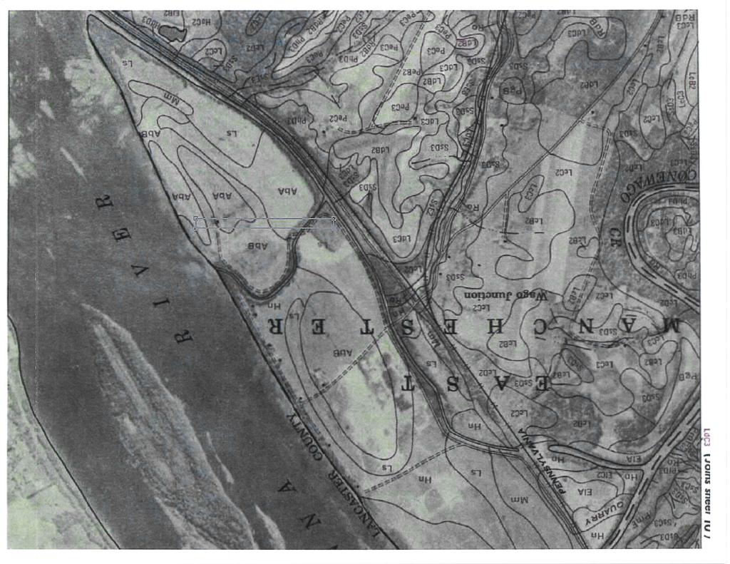
10 This custom soils report for Basin 6 is provided as Attachment B and shows there are two different types of land at Basin 6. These types of land are Urban Land (Uc) and Water (W), which consists of approximately 80% and 20% of the total area of Basin 6, respectively. Neither of these land types are considered hydric. A historic soil survey map of Brunner Island dated 1963 was located and reviewed. This historic map is also included in Attachment B. It shows soils that were mapped in the area of Basin 6 prior to construction of the basin. Those soils included well drained Aston loam (AbA and AbB), moderately well drained Linside silt loam (Ls), as well as a small area of poorly drained Melvin silt loam (MM). The area of poorly drained soils appear to have been located near the southwest corner of the current footprint of Basin 6. However, we are unable to determine if that area of historically mapped Melvin silt loam was inside the footprint of Basin 6 or if there were any wetlands present. 3.4 SITE INSPECTION Advanced GeoServices personnel familiar with wetland delineation performed a Site inspection of Basin 6 on May 4, At the time of the inspection, there were no indications that wetlands existed within Basin 6. The location of Basin 6 was verified to be earthen berms, a polishing pond, an ash settling pond, and an area of dry ash currently being harvested for beneficial use. There were some areas adjacent to Basin 6 that appeared to be wet, as well as evidence of some potential seeps of groundwater from the toe of the earthen berm slopes that appeared to be the source of water for the wet areas downgradient and outside of Basin 6. However, these areas were either not on the Basin 6 area or, based on construction documentation, not anticipated to be constructed from hydric soils and would not be considered wetlands. In addition, there was no indication that any of these wet areas either existed before the construction of Basin 6, or if they did exist, that their boundaries would have extended into the location of Basin 6 itself. 3.5 CONCLUSIONS Based upon our review, it is Advanced GeoServices opinion that there are no wetlands within the Basin 6 footprint. This opinion is based on the following: Basin 6 was constructed in the 1970s, more than a decade prior to the term Wetlands being defined by regulation. A review of the History of Construction (GeoSyntec Consultants, 2016) did not identify the presence of wetlands. The Basin 6 construction materials would not be considered hydric soils. 3-3
11 A site inspection by our personnel on May 4, 2018, did not identify potential wetland indicators in or near Basin 6. The wetlands are not identified on or within the Basin 6 area in the current NWI Map along the Susquehanna River. A review of the geotechnical boring logs from 1975 and 1977 uncovered only three (3) out of more than forty (40) logs that indicated a water level of inches. One of three requirements to support a wetlands classification is having an instantaneous groundwater levels within 18-inches of the surface. All other well logs showed water was encountered at much deeper depths. 3-4
12 4.0 LIMITATIONS The signature of Advanced GeoServices authorized representative on this document represents that, to the best of our knowledge, information, and belief, it is our professional opinion that the aforementioned information is accurate as of the date of such signature. Our opinion is made on the basis of our experience, qualifications, and professional judgment and is not to be construed as a warranty or guaranty. In addition, opinions relating to environmental, geologic, and geotechnical conditions or other estimates are based on available data, and actual conditions may vary from those encountered at the times and locations where data are obtained, despite the use of due care. 4-1
13 5.0 REFERENCES Coal Combustion Residual (CCR) Rule 40 CFR Geosyntec Consultants (2016) History of Construction. Geosyntec Consultants, October 2016 PADEP (2008). Permit for Solid Waste Permit No Pennsylvania Department of Environmental Protection, Waste Management Division, Southcentral Region. Harrisburg, PA. United States Environmental Protection Agency (USEPA) (2015). Hazardous and Solid Waste Management System; Disposal of Coal Combustion Residuals from Electric Utilities; Final Rule. Chapter 40 Code of Federal Regulations, Parts 257 and April United Stated Fish and Wildlife Service (USFWS) (2018) National Wetlands Inventory, Brunner Basin 6. NWI Mapper web site. United States Department of Agriculture (USDA) (2018) Custom Soil Resource Report for York County, Pennsylvania, Brunner Basin 6. National Resources Conservation Service Web Soil Survey web site. g:\projects\2018\ ccr location restrictions\work documents\wetlands\certification report\final\bi_basin 6_wetlands location restriction_final draft.docx 5-1
14 FIGURES
15 Engineering for the Environment. Planning for People. F:\Projects\2015\ Brunner Detection Monitoring Systems\Cad\Drawings\Ash Basin 6 Updated Figures.dwg TM
16 Engineering for the Environment. Planning for People. F:\Projects\2015\ Brunner Detection Monitoring Systems\Cad\Drawings\Ash Basin 6 Updated Figures.dwg 2 TM
17 F:\Projects\2015\ Brunner Detection Monitoring Systems\Cad\Drawings\Ash Basin 6 Updated Figures.dwg Engineering for the Environment. Planning for People. TM
18 ATTACHMENT A

19 Brunner - Basin 6 1:14, mi km U.S. Fish and Wildlife Service, National Standards and Support Team, wetlands_team@fws.gov April 23, 2018 Wetlands Estuarine and Marine Deepwater Freshwater Emergent Wetland Freshwater Forested/Shrub Wetland Lake Other This map is for general reference only. The US Fish and Wildlife Service is not responsible for the accuracy or currentness of the base data shown on this map. All wetlands related data should be used in accordance with the layer metadata found on the Wetlands Mapper web site. Estuarine and Marine Wetland Freshwater Pond Riverine National Wetlands Inventory (NWI) This page was produced by the NWI mapper
20 4/23/2018 Wetlands Code Interpreter Enter Classification code: (Example: L1UB1Hx ) Optional: For geographically specific information*, please enter a State code: (Example: TX for Texas) CLICK HERE TO DECODE Description for code L1UBHh: L System LACUSTRINE: The Lacustrine System includes wetlands and deepwater habitats with all of the following characteristics: (1) situated in a topographic depression or a dammed river channel; (2) lacking trees, shrubs, persistent emergents, emergent mosses or lichens with 30 percent or greater areal coverage; and (3) total area of at least 8 hectares (ha) (20 acres). Similar wetlands and deepwater habitats totaling less than 8 ha are also included in the Lacustrine System if an active wave-formed or bedrock shoreline feature makes up all or part of the boundary, or if the water depth in the deepest part of the basin equals or exceeds 2.5 m (8.2 ft) at low water. Lacustrine waters may be tidal or nontidal, but ocean-derived salinity is always less than 0.5 ppt. 1 Subsystem LIMNETIC: This subsystem includes all deepwater habitats (i.e., areas > 2.5 m [8.2 ft] deep below low water) in the Lacustrine System. Many small Lacustrine Systems have no Limnetic Subsystem. UB Class UNCONSOLIDATED BOTTOM: Includes all wetlands and deepwater habitats with at least 25% cover of particles smaller than stones (less than 6-7 cm), and a vegetative cover less than 30%. H Water Regime Permanently Flooded : Water covers the substrate throughout the year in all years. Other Modifier(s): h SPECIAL MODIFIER Diked/Impounded : These wetlands have been created or modified by a man-made barrier or dam that obstructs the inflow or outflow of water. 1/1
21 ATTACHMENT B


22 United States Department of Agriculture Natural Resources Conservation Service A product of the National Cooperative Soil Survey, a joint effort of the United States Department of Agriculture and other Federal agencies, State agencies including the Agricultural Experiment Stations, and local participants Custom Soil Resource Report for York County, Pennsylvania Brunner - Basin 6 April 23, 2018
23 Preface Soil surveys contain information that affects land use planning in survey areas. They highlight soil limitations that affect various land uses and provide information about the properties of the soils in the survey areas. Soil surveys are designed for many different users, including farmers, ranchers, foresters, agronomists, urban planners, community officials, engineers, developers, builders, and home buyers. Also, conservationists, teachers, students, and specialists in recreation, waste disposal, and pollution control can use the surveys to help them understand, protect, or enhance the environment. Various land use regulations of Federal, State, and local governments may impose special restrictions on land use or land treatment. Soil surveys identify soil properties that are used in making various land use or land treatment decisions. The information is intended to help the land users identify and reduce the effects of soil limitations on various land uses. The landowner or user is responsible for identifying and complying with existing laws and regulations. Although soil survey information can be used for general farm, local, and wider area planning, onsite investigation is needed to supplement this information in some cases. Examples include soil quality assessments ( portal/nrcs/main/soils/health/) and certain conservation and engineering applications. For more detailed information, contact your local USDA Service Center ( or your NRCS State Soil Scientist ( cid=nrcs142p2_053951). Great differences in soil properties can occur within short distances. Some soils are seasonally wet or subject to flooding. Some are too unstable to be used as a foundation for buildings or roads. Clayey or wet soils are poorly suited to use as septic tank absorption fields. A high water table makes a soil poorly suited to basements or underground installations. The National Cooperative Soil Survey is a joint effort of the United States Department of Agriculture and other Federal agencies, State agencies including the Agricultural Experiment Stations, and local agencies. The Natural Resources Conservation Service (NRCS) has leadership for the Federal part of the National Cooperative Soil Survey. Information about soils is updated periodically. Updated information is available through the NRCS Web Soil Survey, the site for official soil survey information. The U.S. Department of Agriculture (USDA) prohibits discrimination in all its programs and activities on the basis of race, color, national origin, age, disability, and where applicable, sex, marital status, familial status, parental status, religion, sexual orientation, genetic information, political beliefs, reprisal, or because all or a part of an individual's income is derived from any public assistance program. (Not all prohibited bases apply to all programs.) Persons with disabilities who require 2
24 alternative means for communication of program information (Braille, large print, audiotape, etc.) should contact USDA's TARGET Center at (202) (voice and TDD). To file a complaint of discrimination, write to USDA, Director, Office of Civil Rights, 1400 Independence Avenue, S.W., Washington, D.C or call (800) (voice) or (202) (TDD). USDA is an equal opportunity provider and employer. 3
25 Contents Preface... 2 How Soil Surveys Are Made...5 Soil Map... 8 Soil Map...9 Legend...10 Map Unit Legend Map Unit Descriptions...11 York County, Pennsylvania Uc Urban land...13 W Water...13 References
26 How Soil Surveys Are Made Soil surveys are made to provide information about the soils and miscellaneous areas in a specific area. They include a description of the soils and miscellaneous areas and their location on the landscape and tables that show soil properties and limitations affecting various uses. Soil scientists observed the steepness, length, and shape of the slopes; the general pattern of drainage; the kinds of crops and native plants; and the kinds of bedrock. They observed and described many soil profiles. A soil profile is the sequence of natural layers, or horizons, in a soil. The profile extends from the surface down into the unconsolidated material in which the soil formed or from the surface down to bedrock. The unconsolidated material is devoid of roots and other living organisms and has not been changed by other biological activity. Currently, soils are mapped according to the boundaries of major land resource areas (MLRAs). MLRAs are geographically associated land resource units that share common characteristics related to physiography, geology, climate, water resources, soils, biological resources, and land uses (USDA, 2006). Soil survey areas typically consist of parts of one or more MLRA. The soils and miscellaneous areas in a survey area occur in an orderly pattern that is related to the geology, landforms, relief, climate, and natural vegetation of the area. Each kind of soil and miscellaneous area is associated with a particular kind of landform or with a segment of the landform. By observing the soils and miscellaneous areas in the survey area and relating their position to specific segments of the landform, a soil scientist develops a concept, or model, of how they were formed. Thus, during mapping, this model enables the soil scientist to predict with a considerable degree of accuracy the kind of soil or miscellaneous area at a specific location on the landscape. Commonly, individual soils on the landscape merge into one another as their characteristics gradually change. To construct an accurate soil map, however, soil scientists must determine the boundaries between the soils. They can observe only a limited number of soil profiles. Nevertheless, these observations, supplemented by an understanding of the soil-vegetation-landscape relationship, are sufficient to verify predictions of the kinds of soil in an area and to determine the boundaries. Soil scientists recorded the characteristics of the soil profiles that they studied. They noted soil color, texture, size and shape of soil aggregates, kind and amount of rock fragments, distribution of plant roots, reaction, and other features that enable them to identify soils. After describing the soils in the survey area and determining their properties, the soil scientists assigned the soils to taxonomic classes (units). Taxonomic classes are concepts. Each taxonomic class has a set of soil characteristics with precisely defined limits. The classes are used as a basis for comparison to classify soils systematically. Soil taxonomy, the system of taxonomic classification used in the United States, is based mainly on the kind and character of soil properties and the arrangement of horizons within the profile. After the soil 5
27 Custom Soil Resource Report scientists classified and named the soils in the survey area, they compared the individual soils with similar soils in the same taxonomic class in other areas so that they could confirm data and assemble additional data based on experience and research. The objective of soil mapping is not to delineate pure map unit components; the objective is to separate the landscape into landforms or landform segments that have similar use and management requirements. Each map unit is defined by a unique combination of soil components and/or miscellaneous areas in predictable proportions. Some components may be highly contrasting to the other components of the map unit. The presence of minor components in a map unit in no way diminishes the usefulness or accuracy of the data. The delineation of such landforms and landform segments on the map provides sufficient information for the development of resource plans. If intensive use of small areas is planned, onsite investigation is needed to define and locate the soils and miscellaneous areas. Soil scientists make many field observations in the process of producing a soil map. The frequency of observation is dependent upon several factors, including scale of mapping, intensity of mapping, design of map units, complexity of the landscape, and experience of the soil scientist. Observations are made to test and refine the soil-landscape model and predictions and to verify the classification of the soils at specific locations. Once the soil-landscape model is refined, a significantly smaller number of measurements of individual soil properties are made and recorded. These measurements may include field measurements, such as those for color, depth to bedrock, and texture, and laboratory measurements, such as those for content of sand, silt, clay, salt, and other components. Properties of each soil typically vary from one point to another across the landscape. Observations for map unit components are aggregated to develop ranges of characteristics for the components. The aggregated values are presented. Direct measurements do not exist for every property presented for every map unit component. Values for some properties are estimated from combinations of other properties. While a soil survey is in progress, samples of some of the soils in the area generally are collected for laboratory analyses and for engineering tests. Soil scientists interpret the data from these analyses and tests as well as the field-observed characteristics and the soil properties to determine the expected behavior of the soils under different uses. Interpretations for all of the soils are field tested through observation of the soils in different uses and under different levels of management. Some interpretations are modified to fit local conditions, and some new interpretations are developed to meet local needs. Data are assembled from other sources, such as research information, production records, and field experience of specialists. For example, data on crop yields under defined levels of management are assembled from farm records and from field or plot experiments on the same kinds of soil. Predictions about soil behavior are based not only on soil properties but also on such variables as climate and biological activity. Soil conditions are predictable over long periods of time, but they are not predictable from year to year. For example, soil scientists can predict with a fairly high degree of accuracy that a given soil will have a high water table within certain depths in most years, but they cannot predict that a high water table will always be at a specific level in the soil on a specific date. After soil scientists located and identified the significant natural bodies of soil in the survey area, they drew the boundaries of these bodies on aerial photographs and 6
28 Custom Soil Resource Report identified each as a specific map unit. Aerial photographs show trees, buildings, fields, roads, and rivers, all of which help in locating boundaries accurately. 7
29 Soil Map The soil map section includes the soil map for the defined area of interest, a list of soil map units on the map and extent of each map unit, and cartographic symbols displayed on the map. Also presented are various metadata about data used to produce the map, and a description of each soil map unit. 8

30 76 41' 20'' W Custom Soil Resource Report Soil Map 76 40' 37'' W 40 5' 10'' N ' 10'' N Soil Map may not be valid at this scale ' 26'' N ' 26'' N 76 41' 20'' W N Map Scale: 1:6,630 if printed on A portrait (8.5" x 11") sheet. Meters Feet Map projection: Web Mercator Corner coordinates: WGS84 Edge tics: UTM Zone 18N WGS ' 37'' W
31 Custom Soil Resource Report MAP LEGEND MAP INFORMATION Area of Interest (AOI) Area of Interest (AOI) Soils Soil Map Unit Polygons Soil Map Unit Lines Soil Map Unit Points Special Point Features Blowout Borrow Pit Clay Spot Closed Depression Gravel Pit Gravelly Spot Landfill Lava Flow Marsh or swamp Mine or Quarry Miscellaneous Water Perennial Water Rock Outcrop Saline Spot Sandy Spot Severely Eroded Spot Sinkhole Slide or Slip Sodic Spot Spoil Area Stony Spot Very Stony Spot Wet Spot Other Special Line Features Water Features Streams and Canals Transportation Rails Interstate Highways US Routes Major Roads Local Roads Background Aerial Photography The soil surveys that comprise your AOI were mapped at 1:24,000. Warning: Soil Map may not be valid at this scale. Enlargement of maps beyond the scale of mapping can cause misunderstanding of the detail of mapping and accuracy of soil line placement. The maps do not show the small areas of contrasting soils that could have been shown at a more detailed scale. Please rely on the bar scale on each map sheet for map measurements. Source of Map: Natural Resources Conservation Service Web Soil Survey URL: Coordinate System: Web Mercator (EPSG:3857) Maps from the Web Soil Survey are based on the Web Mercator projection, which preserves direction and shape but distorts distance and area. A projection that preserves area, such as the Albers equal-area conic projection, should be used if more accurate calculations of distance or area are required. This product is generated from the USDA-NRCS certified data as of the version date(s) listed below. Soil Survey Area: York County, Pennsylvania Survey Area Data: Version 11, Oct 4, 2017 Soil map units are labeled (as space allows) for map scales 1:50,000 or larger. Date(s) aerial images were photographed: Mar 26, 2011 Jul 2, 2011 The orthophoto or other base map on which the soil lines were compiled and digitized probably differs from the background imagery displayed on these maps. As a result, some minor shifting of map unit boundaries may be evident. 10
32 Custom Soil Resource Report Map Unit Legend Map Unit Symbol Map Unit Name Acres in AOI Percent of AOI Uc Urban land % W Water % Totals for Area of Interest % Map Unit Descriptions The map units delineated on the detailed soil maps in a soil survey represent the soils or miscellaneous areas in the survey area. The map unit descriptions, along with the maps, can be used to determine the composition and properties of a unit. A map unit delineation on a soil map represents an area dominated by one or more major kinds of soil or miscellaneous areas. A map unit is identified and named according to the taxonomic classification of the dominant soils. Within a taxonomic class there are precisely defined limits for the properties of the soils. On the landscape, however, the soils are natural phenomena, and they have the characteristic variability of all natural phenomena. Thus, the range of some observed properties may extend beyond the limits defined for a taxonomic class. Areas of soils of a single taxonomic class rarely, if ever, can be mapped without including areas of other taxonomic classes. Consequently, every map unit is made up of the soils or miscellaneous areas for which it is named and some minor components that belong to taxonomic classes other than those of the major soils. Most minor soils have properties similar to those of the dominant soil or soils in the map unit, and thus they do not affect use and management. These are called noncontrasting, or similar, components. They may or may not be mentioned in a particular map unit description. Other minor components, however, have properties and behavioral characteristics divergent enough to affect use or to require different management. These are called contrasting, or dissimilar, components. They generally are in small areas and could not be mapped separately because of the scale used. Some small areas of strongly contrasting soils or miscellaneous areas are identified by a special symbol on the maps. If included in the database for a given area, the contrasting minor components are identified in the map unit descriptions along with some characteristics of each. A few areas of minor components may not have been observed, and consequently they are not mentioned in the descriptions, especially where the pattern was so complex that it was impractical to make enough observations to identify all the soils and miscellaneous areas on the landscape. The presence of minor components in a map unit in no way diminishes the usefulness or accuracy of the data. The objective of mapping is not to delineate pure taxonomic classes but rather to separate the landscape into landforms or landform segments that have similar use and management requirements. The delineation of such segments on the map provides sufficient information for the development of resource plans. If intensive use of small areas is planned, however, 11
33 Custom Soil Resource Report onsite investigation is needed to define and locate the soils and miscellaneous areas. An identifying symbol precedes the map unit name in the map unit descriptions. Each description includes general facts about the unit and gives important soil properties and qualities. Soils that have profiles that are almost alike make up a soil series. Except for differences in texture of the surface layer, all the soils of a series have major horizons that are similar in composition, thickness, and arrangement. Soils of one series can differ in texture of the surface layer, slope, stoniness, salinity, degree of erosion, and other characteristics that affect their use. On the basis of such differences, a soil series is divided into soil phases. Most of the areas shown on the detailed soil maps are phases of soil series. The name of a soil phase commonly indicates a feature that affects use or management. For example, Alpha silt loam, 0 to 2 percent slopes, is a phase of the Alpha series. Some map units are made up of two or more major soils or miscellaneous areas. These map units are complexes, associations, or undifferentiated groups. A complex consists of two or more soils or miscellaneous areas in such an intricate pattern or in such small areas that they cannot be shown separately on the maps. The pattern and proportion of the soils or miscellaneous areas are somewhat similar in all areas. Alpha-Beta complex, 0 to 6 percent slopes, is an example. An association is made up of two or more geographically associated soils or miscellaneous areas that are shown as one unit on the maps. Because of present or anticipated uses of the map units in the survey area, it was not considered practical or necessary to map the soils or miscellaneous areas separately. The pattern and relative proportion of the soils or miscellaneous areas are somewhat similar. Alpha-Beta association, 0 to 2 percent slopes, is an example. An undifferentiated group is made up of two or more soils or miscellaneous areas that could be mapped individually but are mapped as one unit because similar interpretations can be made for use and management. The pattern and proportion of the soils or miscellaneous areas in a mapped area are not uniform. An area can be made up of only one of the major soils or miscellaneous areas, or it can be made up of all of them. Alpha and Beta soils, 0 to 2 percent slopes, is an example. Some surveys include miscellaneous areas. Such areas have little or no soil material and support little or no vegetation. Rock outcrop is an example. 12
34 Custom Soil Resource Report York County, Pennsylvania Uc Urban land Map Unit Setting National map unit symbol: l6zp Mean annual precipitation: 36 to 50 inches Mean annual air temperature: 46 to 59 degrees F Frost-free period: 120 to 215 days Farmland classification: Not prime farmland Map Unit Composition Urban land: 90 percent Minor components: 10 percent Estimates are based on observations, descriptions, and transects of the mapunit. Description of Urban Land Setting Down-slope shape: Linear Across-slope shape: Linear Parent material: Pavement, buildings and other artifically covered areas Properties and qualities Slope: 0 to 8 percent Depth to restrictive feature: 10 inches to densic material Runoff class: Very high Interpretive groups Land capability classification (irrigated): None specified Land capability classification (nonirrigated): 8s Hydric soil rating: No Minor Components Udorthents, steep Percent of map unit: 10 percent Landform: Mountains Landform position (two-dimensional): Summit, backslope Landform position (three-dimensional): Mountaintop Down-slope shape: Convex Across-slope shape: Convex Hydric soil rating: No W Water Map Unit Setting National map unit symbol: l6zv Mean annual precipitation: 36 to 50 inches Mean annual air temperature: 46 to 59 degrees F 13
35 Custom Soil Resource Report Frost-free period: 120 to 214 days Farmland classification: Not prime farmland Map Unit Composition Water: 100 percent Estimates are based on observations, descriptions, and transects of the mapunit. Description of Water Setting Parent material: Rivers streams ponds Properties and qualities Runoff class: Negligible Frequency of ponding: Frequent 14
36 References American Association of State Highway and Transportation Officials (AASHTO) Standard specifications for transportation materials and methods of sampling and testing. 24th edition. American Society for Testing and Materials (ASTM) Standard classification of soils for engineering purposes. ASTM Standard D Cowardin, L.M., V. Carter, F.C. Golet, and E.T. LaRoe Classification of wetlands and deep-water habitats of the United States. U.S. Fish and Wildlife Service FWS/OBS-79/31. Federal Register. July 13, Changes in hydric soils of the United States. Federal Register. September 18, Hydric soils of the United States. Hurt, G.W., and L.M. Vasilas, editors. Version 6.0, Field indicators of hydric soils in the United States. National Research Council Wetlands: Characteristics and boundaries. Soil Survey Division Staff Soil survey manual. Soil Conservation Service. U.S. Department of Agriculture Handbook nrcs/detail/national/soils/?cid=nrcs142p2_ Soil Survey Staff Soil taxonomy: A basic system of soil classification for making and interpreting soil surveys. 2nd edition. Natural Resources Conservation Service, U.S. Department of Agriculture Handbook Soil Survey Staff Keys to soil taxonomy. 11th edition. U.S. Department of Agriculture, Natural Resources Conservation Service. Tiner, R.W., Jr Wetlands of Delaware. U.S. Fish and Wildlife Service and Delaware Department of Natural Resources and Environmental Control, Wetlands Section. United States Army Corps of Engineers, Environmental Laboratory Corps of Engineers wetlands delineation manual. Waterways Experiment Station Technical Report Y United States Department of Agriculture, Natural Resources Conservation Service. National forestry manual. home/?cid=nrcs142p2_ United States Department of Agriculture, Natural Resources Conservation Service. National range and pasture handbook. detail/national/landuse/rangepasture/?cid=stelprdb
37 Custom Soil Resource Report United States Department of Agriculture, Natural Resources Conservation Service. National soil survey handbook, title 430-VI. nrcs/detail/soils/scientists/?cid=nrcs142p2_ United States Department of Agriculture, Natural Resources Conservation Service Land resource regions and major land resource areas of the United States, the Caribbean, and the Pacific Basin. U.S. Department of Agriculture Handbook cid=nrcs142p2_ United States Department of Agriculture, Soil Conservation Service Land capability classification. U.S. Department of Agriculture Handbook
38