Detailed discussion of the Petroleum Vapor Database is provided in Davis R.V., 2009, LUSTLine #61 and EPA Jan
|
|
|
- Maria Chambers
- 5 years ago
- Views:
Transcription
1 1
2 The objective of studying and evaluating the behavior of subsurface petroleum vapors is to understand why, with so many LUST sites worldwide, the PVI pathway is rarely complete. Advancing our knowledge by using basic, routine field data enables us to develop screening criteria to determine when PVI investigations are necessary. Detailed discussion of the Petroleum Vapor Database is provided in Davis R.V., 2009, LUSTLine #61 and EPA Jan
3 The scope of evaluating the PVI pathway involves collecting and compiling basic site data (Petroleum Vapor Database). A LUST site must be fully characterized by collecting basic, good-quality data wherein the nature, extent & degree of contamination and contaminant sources are fully defined (required by 40 CFR Part 280) and provide knowledge of contaminant distribution in soil and groundwater, including temporal effects such as fluctuating DTW. Once these subsurface characteristics are understood, LUST PMs can better understand if the PVI pathway may be complete and if VI investigations are really necessary. VI investigations are costly and highly invasive to properties and their occupants, and unnecessary work should be avoided. Time Line of Studies 2002: EPA OSWER Draft Guide for Vapor Intrusion Evaluations : EPA OUST/States Petroleum Vapor Intrusion Work Group : Continued independent data compilation, analysis : EPA OUST/States PVI Work Group Revived : Database much larger, EPA OUST peer-reviewed and published Database Report Jan 2013, published modeling studies, validated Bio Vapor Model (Analytical Model by DeVaull and McHugh, 2010), EPA OUST draft PVI guidance Apr 2013, ITRC PVI guidance Oct
 used the same data to develop screening criteria.")
4 Map showing the number of geographic locations and soil vapor sample events (benzene) in the Petroleum Vapor Database (Davis, R.V., 2009, 2010, 2011). EPA (2013) used the same data to develop screening criteria. The data were collected over a 16-year time frame from multi-depth exterior and sub-slab vapor sample points, and conventional groundwater monitoring wells. These data are used for evaluating subsurface vapor attenuation spatially and temporally. Data are currently available from sites in United States, Canada and Australia (Jackie Wright, 2011, 2012). There are approximately equal numbers of geographic locations and soil vapor events for benzene and TPH measurements. The database contains measurements of GW depth and soil type, and concurrent measurements of LNAPL and contaminant concentrations in the adsorbed, dissolved and vapor phases. Available soil boring logs were studied to better understand vadose zone soil characteristics. 4
5 5
 Close proximity of LNAPL or very high dissolved concentrations to a building foundation that fluctuation GW levels bring contamination in direct contact")
6 Practical field experience and published literature of field studies show that petroleum vapor intrusion impacts are generally associated with: 1) Direct contact of LNAPL or very high dissolved concentrations to a building foundation 2) Close proximity of LNAPL or very high dissolved concentrations to a building foundation that fluctuation GW levels bring contamination in direct contact with building 3) Direct contact of LNAPL or very high dissolved concentrations to building sumps, elevator shafts 4) Direct contact of LNAPL or very high dissolved concentrations with preferential pathway (e.g., improperly-sealed utility lines) Key Points: Field data confirm that petroleum vapor intrusion impacts are associated with high contaminant concentrations, and that vapor intrusion does not occur with low concentrations of petroleum hydrocarbons dissolved in groundwater or adsorbed in soil. 6
7 Vapor profiles of multi-depth vapor probes showing the signature characteristics of aerobic biodegradation of petroleum hydrocarbon (PHC): Aerobic soil microbes use oxygen in the process of capturing the carbon as food from the petroleum hydrocarbon. The resulting waste product is carbon dioxide. Therefore, near the contaminant source, O2 is depleted and CO2 is enriched. As the PHC is biodegraded, PHC vapor concentrations decrease, and O2 and CO2 rebound to near-atmospheric concentrations. Typical O2, CO2, PHC vapor profiles: petroleum vapors naturally biodegrade & attenuate with sufficient thickness of non-source vadose zone soil 1000 s of such measurements yield consistent, predictable results Extent & magnitude of vapor attenuation can be quantified, & Screening Criteria developed & applied 7
8 PHC vapors cannot attenuate because there is insufficient thickness of nonsource soil overlying the contaminated soil source. Without shallower vapor completion points, there is no way of knowing if vapors decrease and soil oxygen concentrations increase before reaching an overlying receptor. 8
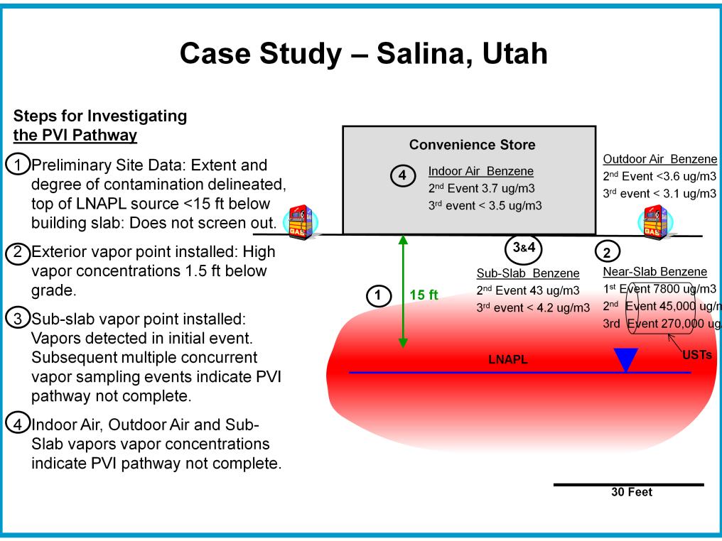
9 This slide shows benzene and TPH multi-depth vapor profiles of vapor well VW- 11 from two different sampling dates, the earlier 8/06 event having no shallow completion above the LNAPL soil, thus fails to determine if vapors attenuate and if PVI pathway is complete. Vapor concentrations are very high within the contaminated soil zone (red shading) and, from the 8/26/06 sampling event where the shallowest vapor sample was obtained from 4 feet deep, vapors appear to not attenuate below the overlying paved road. However, on 6/27/07, vapor samples obtained from 2.5 feet deep showed nearly complete vapor attenuation. Leak testing confirmed the good integrity of each completion point. Some practitioners maintain that vapor completion points set too shallow (some say <5 feet deep) may be subject to short-circuiting or otherwise drawing in atmospheric air, causing a false-negative effect on vapor analyses. Others argue that this effect is not occurring at most sites because, according to standard sampling practices, vapor samples are obtained relatively quickly ( grab samples ) and draw vapor in from the area directly around the completion point. Studies in Utah show that only faulty completion points or unnecessarily long sampling times result in drawing in atmospheric air. VW-11 is an example that shows the benefits of shallow completion points dispelling the notion that short-circuiting might occur. 9

10 10

11 - Site characterization is routine and necessary in order to know if receptors are impacted. Title 40 of the Code of Federal Regulations, Part 280 for leaking USTs requires that sites be fully characterized by conducting subsurface investigations wherein the full extent and degree of contamination are defined. The presence and thickness of non-source soil above contaminant sources are generally known in the early phases of site characterization by advancing soil borings, logging the borings, and completing as GW monitoring wells. - Non-source soil, also called Clean Soil. is free of LNAPL and contains the necessary oxygen for biodegrading PHCs. Clean, non-source soil is easily characterized by logging borings/mws, field PID measurements, visual and olfactory observations of soil cores, and collecting soil samples and analyzing for constituents of concern. - Build a Conceptual Site Model based on site-specific data. - Volatile compounds associated with LNAPL, contaminated soil, and very high dissolved contaminant concentrations can generate very high vapor concentrations that, when in close proximity to buildings or utilities, can cause PVI. Those conditions are the only known cases of petroleum vapor intrusion: There are no known or reported cases of petroleum vapor intrusion associated with low dissolved-phase concentrations at or near buildings or utilities. - Contaminants partition to vapor phase from soil and LNAPL source according to Raoult s Law. Contaminants dissolved in GW partition to vapor phase according to Henry s Law Constant. 11
12 Vapor Profiles Left Panel: Benzene vapor concentrations emanating from a very high-strength dissolved source attenuate with 4.94 feet of overlying soil. Right Panel: Benzene vapor concentrations emanating from a low-strength dissolved source are very low, and attenuate with 4 feet of non-source overlying soil and only 4 feet above the groundwater surface. 12

13 Vapor Profiles Left Panel: Benzene vapor concentrations emanating from a very high-strength dissolved source attenuate with 4.94 feet of overlying soil. Right Panel: Benzene vapor concentrations emanating from a low-strength dissolved source are very low, and attenuate with 4 feet of non-source overlying soil and only 4 feet above the groundwater surface. 13

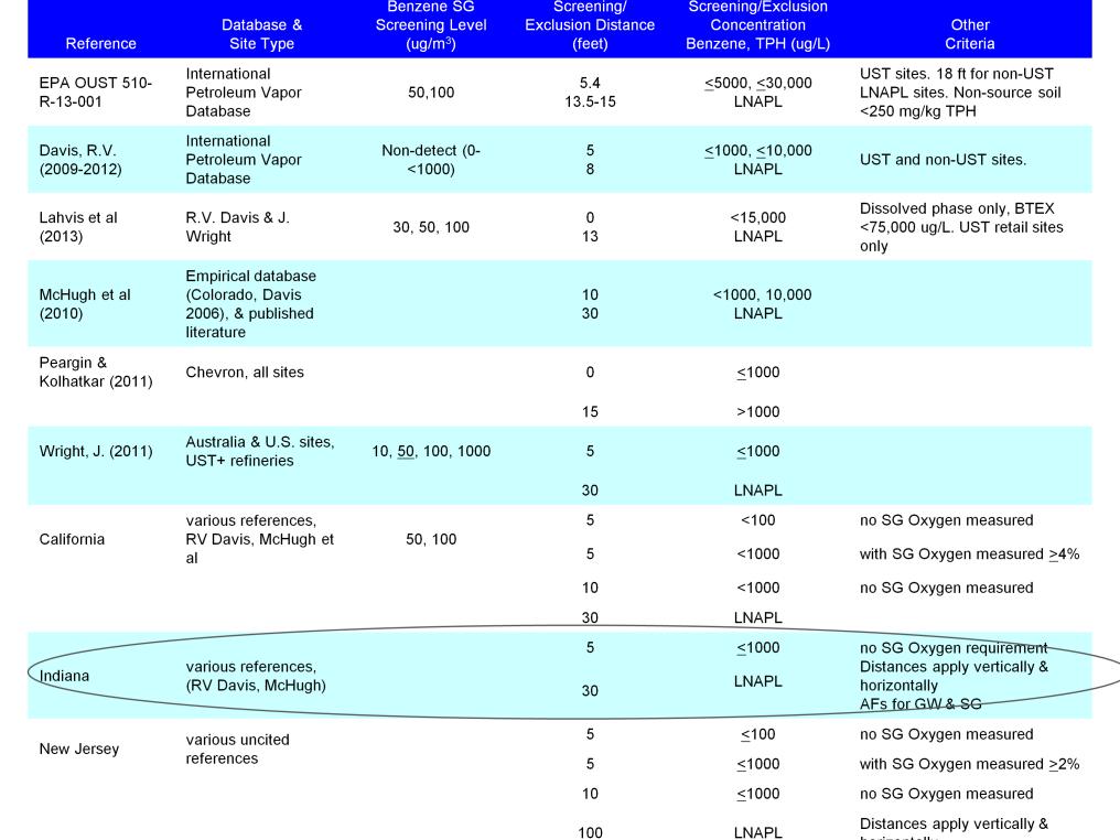
14 - The Petroleum Vapor database (Davis 2009, 2011) contains high-quality data from hundreds of paired field measurements of dissolved-phase and associated vapor-phase benzene and TPH. - Different methods of data analysis yield consistent results of the thickness of nonsource overlying soil necessary to fully attenuate vapors from their respective dissolved source strengths (Davis 2009; EPA 2013; Lahvis et al 2013). Criteria for Evaluating Data Set - Non-source soil overlies groundwater (dissolved sources) - Known depth to groundwater and dissolved sources - Groundwater & soil vapor data collected at about same time (concurrent) from close proximity - Complete attenuation of soil vapors defined by shallow soil vapors = 0 or <DL (which does vary; full attenuation verified by samplers/authors) - Majority of soil vapor measurements from multi-depth soil vapor points, representative sub-slab events included - LUST sites AND refineries -LNAPL sites evaluated separately by EPA and Lahvis et al
15 This Method shows how the empirical database was analyzed for vapor attenuation from LNAPL sites. This Method shows how much soil that contains no LNAPLcontaminated soil, including smear zone, can be used for screening out LNAPL sites, and is also used for screening out sites that have contaminated soil-only with no groundwater impacts. Hal s Green River, Utah site shown in this slide is the subject of a vapor intrusion investigation, and long-term groundwater and soil vapor monitoring. LNAPL extends about 300 feet down-gradient of the site and numerous multi-depth soil vapor monitoring wells were installed. This vapor profile shows high vapor concentrations at the deep depth (15 feet) in the most highly contaminated part of the smear zone. The vapors are fully attenuated vapors just above the contaminated smear zone soil at 11 feet. This data set therefore plots on the graphs for all sites in the database as requiring 4 feet of non-source overlying soil to attenuate vapors associated with LNAPL and contaminated soil-only sites in the database. Note Another method, Method 1 (not shown here), was first introduced in LUSTLine #61 (Davis, R.V., 2009). It uses an overly conservative method by subtracting the deepest SV point where vapors are attenuated from the depth to groundwater, an evaluation consistent with that for dissolved plumes. That method unnecessarily accounts for smear zone contaminated soil and cannot be used for screening out contaminated soilonly sites. 15

16 This plot shows all LNAPL UST and non-ust sites in the database that were evaluated using the Method shown on the previous slide. The maximum soil thickness of non-source soil, required to attenuate vapors associated with LNAPL sources and contaminated-only soil sites is 8 feet, including refinery sites. Criteria for Evaluating Data Set - Known/suspected depths and intervals of uncontaminated soil, top of contaminated soil and LNAPL smear zone, and deep contaminated SV - Complete attenuation of soil vapors defined by shallow soil vapors = 0, or ug/m3, <DL (which may vary; full attenuation verified by samplers/authors) 16
17 The Database Report is a compilation and analysis of field data from Davis and more recent data from various US states and Australia. The database consists of thousands of measurements of soil gas and associated source strengths from hundreds of sites. 17

18 EPA OUST 2013, Figure 16 a and b. 18
19 Numerous field and numerical studies have identified indicators of LNAPL. 19
. The LNAPL-associated vapors attenuate 15 feet above the source in 95% of the measurements. EPA (Jan.")
20 The vertical distance method involved plotting soil vapor concentration versus distance above a source and estimating the probability for the soil vapor concentration to be less than a given concentration threshold for different distances above the contamination source (EPA 2013). The LNAPL-associated vapors attenuate 15 feet above the source in 95% of the measurements. EPA (Jan. 2013, primary author Ian Hers) evaluation of non-usts (refineries and terminals) indicates 18 feet of non-source soil are required to attenuate vapors, but the certainty is lower (90% confidence) due to the small population of non- UST data. 20

21 Lahvis et al 2013 evaluated the empirical data is an similarly rigorous way as EPA OUST. This Figure 6 from Lahvis et al 2013 GWMR shows a plot of benzene concentrations is soil gas vs. distance above LNAPL source. Plot includes 467 soil gas samples collected at 73 UST sites and 204 vertical sampling locations. Non-detect values are plotted at reporting limit. Greater than 95% of the benzene soil-gas concentrations are 30, 50, or 100 μg/m3)beyond a distance of approximately 13 ft (4 m) above the LNAPL source. 21
22 The empirical database studies show a high probability that PHC vapors associated with various source strengths attenuate within a few feet of the source. 22
23 EPA 2012, Lilian Abreu primary author. 23
.")
24 EPA 2012, Figure 35: Effect of source depth and source-building lateral separation distance on the distribution of hydrocarbon and oxygen in soil gas for a high-strength source (LNAPL). Hydrocarbon and oxygen concentration contour lines are normalized by source and atmospheric concentrations, respectively. The source vapor concentration is 200 mg/l at 8 meters deep (26 feet). Biodegradation rate (lamda) = 0.18h-1. The source concentration is attenuated by 100,000-fold within 20 feet in the vertical direction and 16 feet in the lateral direction. The slightly shorter distance of lateral attenuation is due to the presence of a larger area of non-source, oxygen-rich soil. 24
25 25
26 26
27 27
28 28

29 Soil gas samples collected from deepest point of multi-depth vapor probes, and from GW MW screened across water table (Jewell and Wilson 2011 GWMR; Wilson et al 2013 NTC). Preferred sample collection in Summa canisters and analysis of COCs by TO- 15 and fixed gases by ASTM Purge 3 volumes prior to sampling. Helium leak check on initial sampling events. The limitation of sampling soil gas in GW MWs is the inability to determine vertical attenuation of vapors. 29
30 30
31 31
32 32

33 33