Wood-Pawcatuck Watershed Flood Resiliency Management Plan
|
|
|
- Stewart Byrd
- 5 years ago
- Views:
Transcription


1 Wood-Pawcatuck Watershed Flood Resiliency Management Plan Project Steering Committee Meeting May 21, 2015 Wood-Pawcatuck Watershed Association
2 Meeting Agenda 10:00 10:05 Welcome and Opening Remarks 10:05 10:15 Status Update on Work Completed to Date Baseline Assessment Quality Assurance Project Plan Field Work Planning 10:15 11:45 Field Assessment Methods and Geographic Priorities Bridge, Culvert, and Dam Assessment Stream Geomorphic Assessment Natural Resource Assessment Green Infrastructure Assessment 11:45 12:00 Updated Schedule and Next Steps
3 Work Completed Baseline Assessment Compilation and review of existing studies and background documents Meetings and coordination with RIDEM and watershed towns Watershed resource mapping Watershed questionnaire
4
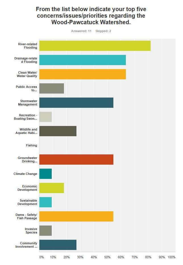
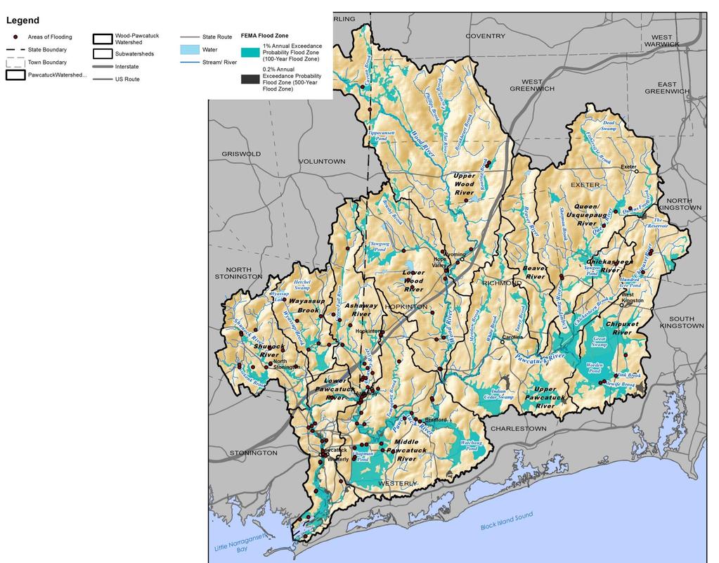
5 Work Completed Baseline Assessment Identification of known/documented areas of flooding (see handout) Hazard Mitigation Plans (missing Charlestown, RI) Comprehensive Plans FEMA Flood Insurance Studies Watershed Questionnaire Please review handout and provide any additional problem areas

6
7 Work Completed Baseline Assessment Baseline Assessment Report outline (see handout) Consistent with Watershed Plan outline suggested by RIDEM Comments from Steering Committee members welcome

8 Work Completed Field Work Planning Quality Assurance Project Plan (QAPP) Private Property Notification Summer Interns - URI Coastal Program Zack Valerio Nate Lukas Field Assessment Methods and Geographic Priorities Technical Memorandum
9 Watershed Technical Assessments Purpose: Evaluate current conditions and opportunities for restoration and protection projects that will enhance flood resiliency Land Use Regulatory Review Quality Assurance Project Plan Watershed Technical Assessments Stream Geomorphic Assessment Green Infrastructure Assessment Bridge, Culvert & Dam Assessment Natural Resources Inventory
10 Assessment Methods & Priorities Technical Memorandum Dated May 7, 2015 Distributed to Steering Committee by WPWA Outlines assessment methods and data sources Desktop and Field Evaluations Proposed geographic priorities Bridge, Culvert, and Dam Assessment Stream Geomorphic Assessment


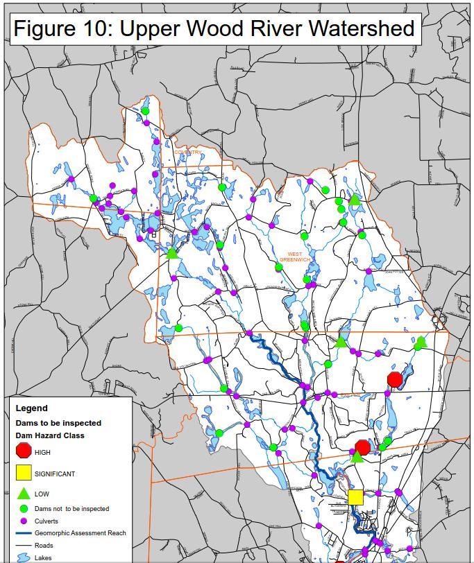
11 Bridge, Culvert & Dam Assessment Assessment of hydraulic structures in the watershed Bridges and Culverts Conveyance capacity and flooding/erosion potential Aquatic connectivity Build on work by USGS, FEMA, USACE, and RI RC&D Dams Flood/erosion damage potential due to breach or failure Dam removal and fish passage feasibility Arcadia Road Bridge, Wood River, March 2010 Blue Pond Dam Breach, Rockville, RI, March 2010
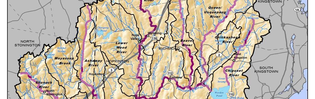
12 Bridge, Culvert & Dam Assessment Bridges and Culverts Locations initially identified Intersected roads, rails, and trails with mapped streams Integrated RI Stream Continuity Project data Approximately 550 structures in the watershed Goal is to inspect/assess all 550 structures (see map handouts) Structures will be prioritized by stream size and flood risk Inspect high-priority structures before low-priority structures

13
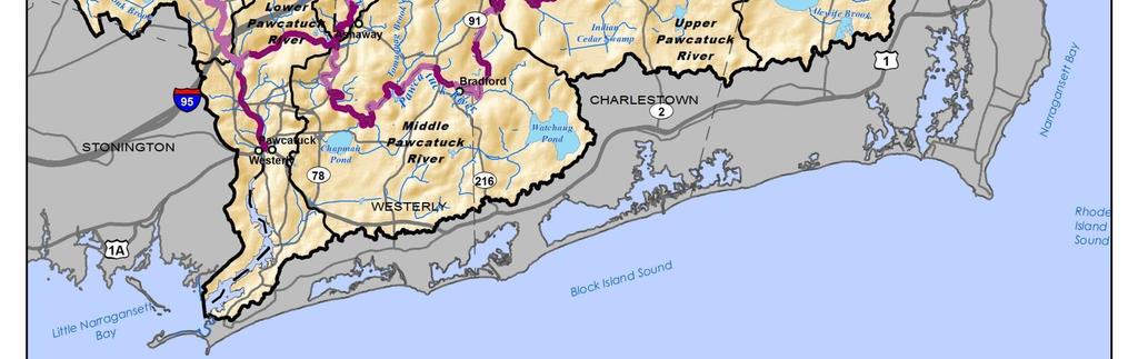
14 Bridge, Culvert & Dam Assessment Bridges and Culverts Field inspections Site characteristics (e.g. aerial sketch, photos, GPS location, street name, road configuration, etc.) Deficiencies and condition of the structure Dimensions and slope of the structure to assess approximate hydraulic capacity Upstream and downstream geomorphic conditions
15 Bridge, Culvert & Dam Assessment Bridges and Culverts Flow conveyance capacity field measurements and FHWA/DOT culvert analysis methods Flood flows USGS StreamStats regression equations and similar hydrologic analysis techniques Flood magnification factors to account for future climate change and urbanization Under-sized culverts will be identified and prioritized Potential for upstream or downstream damage Importance to the community's transportation system Degree to which a culvert is vulnerable to becoming undersized
16 Dams Bridge, Culvert & Dam Assessment Potential removal, repair or modification to reduce flood risk due to dam failure, potential re-purposing to increase flood storage, and to enhance fish passage and aquatic habitat Approximately 150 dams in the watershed Approximately 70 of highest priority dams will be visually inspected (see map handouts) Hazard classification Potential for downstream flood damage (humans, infrastructure, and the environment) Current condition assigned by RIDEM and CTDEEP
17
18 Dams Bridge, Culvert & Dam Assessment Dam inspection protocols developed by the Massachusetts Office of Dam Safety (Phase 1 Formal Dam Safety Inspection Checklist) Classification information (current size, classification, condition, name, location, purpose, etc.) Deficiencies and condition of each part of the structure (embankment, dikes, upstream face, downstream face, appurtenances, walls, concrete structures, masonry structures, spillways, etc.) General published hydrologic information (drainage area, impoundment area, discharge capacity, etc.)

19 Stream Geomorphic Assessment Geomorphic assessment of rivers and streams Protocols adapted from Vermont Fluvial Erosion Hazard Mapping River corridor planning recommendations and design concepts Geomorphic Assessments What are the physical processes and features that characterize a stream and its watershed? How do human activities influence these processes? Which of these processes and features present high erosion and flood hazard risks to human investments?
20 Stream Geomorphic Assessment Phase 1 Assessment Map and aerial photo interpretation Topographic mapping Aerial photos Land use Reach delineation Subdivide the Wood-Pawcatuck into distinct reaches Within a given reach, river is likely to respond similarly to changing watershed conditions Reach breakpoints defined by: Large tributary confluences (or sites of major stormwater inputs) Grade controls (e.g., ledge across the channel, culverts) Abrupt changes in channel slope or valley confinement Significant human impacts (e.g., dams)
21 Stream Geomorphic Assessment Phase 1 Assessment Reaches delineated along a total of 111 river miles River Number of Reaches Identified Pawcatuck River 29 Wood River 27 Shunock River 13 Ashaway-Green Fall River 18 Beaver River 12 Usquepaug-Queen River 24 Chipuxet River 10
22 Stream Geomorphic Assessment Phase 1 Assessment Prioritization of geomorphic reaches for Phase 2 field assessment (due to limited budget) Impounded reaches upstream of dams were removed (not dominated by normal riverine processes) Priority given to reaches with known flooding and erosion problems Priority given to reaches upstream of valley constrictions Priority given to reaches with stream crossings or other infrastructure near the river s edge Assessment results are most valuable when several contiguous reaches are assessed together
23 Stream Geomorphic Assessment Phase 1 Assessment 41 reaches extending over 38.7 miles were prioritized for field assessment (see map handouts) River Number of Reaches Proposed for Field Assessment Pawcatuck River 19 Wood River 12 Other Tributaries 10

24 Source: VT DEC
25 Stream Geomorphic Assessment Phase 2 Assessment Mapping of channel features Identify locations of channel instability and sensitivity Characterize physical habitat conditions Document the impacts of past human activities on channel morphology and evolution (e.g., channel straightening, culverts) Topographic surveying At least one cross section in each reach Additional cross sections where channel morphology varies due to human impacts Disturbed and reference reaches Data used to establish bankfull parameters Substrate particle size analysis (habitat and geomorphic features)
 Assess principal functions of wetlands Identify site-specific")
26 Natural Resource Assessment Riparian Corridor and Floodplain Wetlands Restoration and preservation opportunities for flood mitigation, water quality, and habitat Desktop Screening Evaluation Identify wetlands that provide flood protection function RIDEM and NHDES Methods Field Evaluation of Selected Wetlands (15 locations) Assess principal functions of wetlands Identify site-specific restoration/preservation opportunities Desktop Analysis Screening Criteria Watershed size, slope, topography, vegetation, and impervious cover Wetland storage volume and outflow rate Wetland class Proximity to bridges, dams, roads Area of wetland within floodplain Downstream floodplain development


27 Green Infrastructure Assessment Identify Opportunities for Green Infrastructure Retrofits Enhance resiliency Provide water quality and ecosystem benefits Types of Green Infrastructure Stormwater management/lid Wetland and floodplain restoration
28 Green Infrastructure Assessment Desktop screening Use existing geospatial information and GIS mapping Focus on sites on public land and along public rights-of-way Field inventories of higherpriority sites Field inventory forms adapted from Center for Watershed Protection Data collection to support feasibility determination and concept designs for up to 30 sites Desktop Analysis Screening Criteria Parcel ownership Parcel size and contributing drainage area Soils, infiltration capacity and depth to groundwater Slope Proximity to targeted subwatersheds Surface water quality impairments Proximity to environmentally sensitive or protected areas Impervious area (site and drainage area) Percent impervious Proximity to storm drainage networks Proximity to parks and schools
29 Input Needed from Steering Committee Provide comments/feedback on: 1. Field methods and geographic priorities Technical Memorandum 2. Baseline Watershed Assessment outline 3. Table and map of known areas of flooding (additions, deletions, etc.)
30 Updated Project Schedule Project Kickoff February 2015 Steering Committee Formation March 2015 Steering Committee Meetings (tentative): Project Initiation Meeting March 2015 Progress Meeting #1 May 2015 Progress Meeting #2 November 2015 Progress Meeting #3 April 2016 Field Work Start-up Early June 2015 Baseline and Technical Assessments March December 2015 Plan Development January October 2016 Community Meetings Winter 2015/2016 Municipal Training Fall 2016
31 Project Contacts Contact Information Erik Mas, P.E. Fuss & O Neill, Inc emas@fando.com Denise Poyer Program Director Wood-Pawcatuck Watershed Association denisep@wpwa.org Christopher J. Fox Executive Director Wood-Pawcatuck Watershed Association chris@wpwa.org