OAK RIDGES MORAINE Groundwater Program
|
|
|
- Ella Bryan
- 5 years ago
- Views:
Transcription


1 celebrating 10 ten years OAK RIDGES MORAINE Groundwater Program SINCE 2001 Understanding and collecting the wealth of hydrogeological information generated over the last few decades will allow us to move forward with confidence to address issues related to our water resources. To learn more visit celebrating 10 ten years SINCE 2001 Celebrating Ten Years


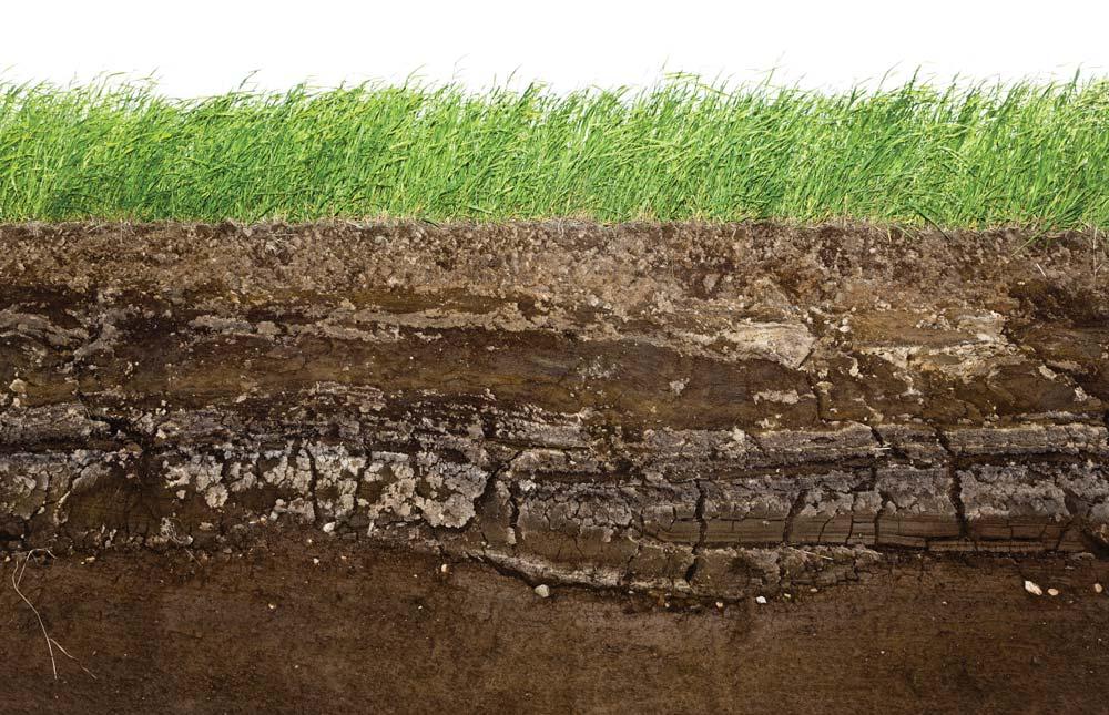
2 2 11 What is Groundwater? When rain falls to the ground, the water does not stop moving. Some of it flows along the surface to streams or lakes, some of it is used by plants, some evaporates and returns to the atmosphere, and some sinks into the ground. Imagine pouring a glass of water onto a pile of sand. The water moves into the spaces between the particles of sand. This water, found between the soil particles or within voids/cracks in rock is referred to as groundwater. Evaporation Vapourtransport Precipitation Lake Surface Runoff River Land Ground waterflow Return flow Hydrologic Cycle


3 10 Importance of Groundwater YPDT - CAMC Program Drilling a monitoring well in Peel Region Groundwater is an important resource within Southern Ontario. It is currently used as a drinking water source by many of the smaller communities situated on and north of the Oak Ridges Moraine, where pipelines from the Great Lakes remain a costly water supply option. Groundwater is also the primary source of water to Ontario's streams during the warm, dry summer months, supporting the area s aquatic ecosystems and fish populations. In addition, groundwater in Ontario is increasingly being used as a geothermal energy source, and is used to support a number of recreational facilities (golf courses, ski hills, irrigated sports fields, etc.). Turning to the agricultural sector, groundwater is often the primary water source for farm water supply, including domestic use, livestock production and irrigation of specialty crops such as fruits and vegetables. All in all groundwater is an important resource that underpins much of southern Ontario's rural agricultural as well as the urban economy surrounding Toronto. The groundwater program of the Regional Municipalities of York, Peel and Durham and the City of Toronto was established in 2001 to help protect and manage our groundwater resources. The Conservation Authorities with jurisdiction on the Oak Ridges Moraine are also partners in the groundwater management program. The program serves as a storeroom for the long-term management of groundwater-related information in the form of data, maps, reports and resource knowledge. The groundwater management program builds, maintains and provides partner agencies with regional geological and hydrogeological context for ongoing groundwater studies and management initiatives within the partnership area. The program is built around four key areas: Database (comprehensive, integrated, and up-to-date) Geology Hydrogeology (including groundwater flow modelling) Planning These fundamentals assist in the development of sound and consistent groundwater management initiatives. An additional benefit of the program is that it provides a forum for groundwater professionals from the partner agencies to collaborate and share local knowledge, program initiatives, data, etc.


, ground water (e.g. water levels, pumping rates,")
 and climate (e.g.")


4 4 9 Database The 2009 Council of Canadian Academies report The Sustainable Management of Groundwater in Canada has put forward these fundamental requirements for effective groundwater management. The requirements are consistent with the groundwater management approach taken within the YPDT-CAMC Groundwater Program since its inception in Decision Making Land use, allocation, pollution prevention, clean-up Groundwater Model Quantitative analysis Hydrogeological Regime Geological Framework Stratigraphic and depositional models Database Accessibility, collection of new and archival data, updates The YPDT-CAMC program has developed a comprehensive database that is the foundation for long-term effective groundwater management. This integrated database incorporates geology (depth to bedrock, thickness of gravel, clay, etc.), ground water (e.g. water levels, pumping rates, chemistry), surface water (e.g. streamflow rates) and climate (e.g. precipitation) related information across the Oak Ridges Moraine area. Is Our Groundwater Clean? Surprisingly to many people, the groundwater in southern Ontario is mostly clean and potable. Only in very localized areas has groundwater become contaminated. Across the Greater Toronto area there is fresh potable groundwater in the upper few hundred metres beneath the ground. As you drill deeper, the water becomes more salty or mineralized due to the length of time it has been in the ground. Water chemically interacts with the glacial sediment and rock, dissolving minerals as it travels. The longer water is in the ground, the more mineralized it becomes. Ongoing source water protection initiatives aims to ensure groundwater in this part of Ontario remains clean and potable. The database was built recognizing effective water management requires access to data, spanning a range of agencies and disciplines. Sound database management is the foundation for credible decisionmaking and effective long-term water management.


 and, after some time moving through")


5 8 5 How Much Groundwater is There? This question is frequently posed to hydrogeologists and cannot be easily answered without detailed technical studies. The groundwater system in our area is fairly dynamic owing to the abundant precipitation we receive (on the order of 800 to 1000 mm/year). Water enters the subsurface in highlands (recharge areas) and, after some time moving through the subsurface, re-emerges at the ground surface in lowlands (e.g. creeks, wetlands and streams (discharge areas). The large rainfall, and the significant amount of groundwater recharge that results, offers many opportunities to extract groundwater for human use. Geology and Hydrogeology Understanding the geology is a critical component of groundwater management. The geological framework is the foundation of the hydrogeologic picture. Over the course of the program numerous sources of information (e.g. reports, drilled boreholes, water chemistry, etc.) have been examined. The hydrogeological analysis seeks to quantify the amount, direction and speed of groundwater movement in the subsurface. For example, a large municipal well in Newmarket can yield 1,000 IGPM or 4,545 L/min. Imagine filling up a typical backyard swimming pool every five to 10 minutes from one well. That s a lot of groundwater. Recharge Area Highlands One of our main challenges is assessing and maintaining the balance between how much groundwater we can safely take and how much is required to support streams and aquatic life. X Discharge Area Creeks & Streams (Lowlands)


6 6 7 Groundwater Flow Modeling Using the YPDT-CAMC database and the geologic/ hydrogeologic analysis as building blocks, the program has produced numerical groundwater models. The models provide a representation of the groundwater flow system and allow resource managers to investigate how the system might respond to changes, such as land use, pumping rate changes or climate change. Recognizing the critical link between groundwater and surface water systems, and the importance of managing both resources in an integrated manner, the models have focused on a better understanding of stream/aquifer interaction. The models are being used for a number of local projects, such as to define well head protection areas for municipal water supply wells, help determine the vulnerability of these wells to potential contaminant sources at the ground surface, and to help assess water quantity resources that support drinking water and ecosystem needs. Planning A solid understanding of the groundwater flow system is essential in guiding land-use decisions. Planners from the partner agencies are involved in the program and are familiar with the way the program s data, geology and modeling tools can support planning decisions. The YPDT- CAMC groundwater understanding is used in the review of site specific development applications and in developing policies on where growth should or should not occur, and how development should be serviced. It is also important that the knowledge of subsurface urf groundwater conditions be incorporated into planned infrastructure projects to protect streamflows, fish habitat, etc.