DRAINAGE MASTER PLAN FOR THE TOWN OF BLOOMING GROVE AND VILLAGES OF WASHINGTONVILLE AND SOUTH BLOOMING GROVE
|
|
|
- Jemimah Sparks
- 5 years ago
- Views:
Transcription


1 DRAINAGE MASTER PLAN FOR THE TOWN OF BLOOMING GROVE AND VILLAGES OF WASHINGTONVILLE AND SOUTH BLOOMING GROVE PUBLIC MEETING March 8, 2017

![pm) [Auditorium] General](/docs-images/88/115696170/images/2-3.jpg "Q&A (7:45 8:00 pm)")
![[Auditorium] OPEN HOUSE](/docs-images/88/115696170/images/2-4.jpg "Open House (8:10 9:00 pm)")
![[Cafeteria] Recap/Thank](/docs-images/88/115696170/images/2-5.jpg "you (9:00 pm) [Cafeteria]")
2 LOGISTICS Meeting Agenda: Presentation (7:15 7:45 pm) [Auditorium] General Q&A (7:45 8:00 pm) [Auditorium] OPEN HOUSE Open House (8:10 9:00 pm) [Cafeteria] Recap/Thank you (9:00 pm) [Cafeteria] AUDITORIUM WE ARE HERE
3 MEETING AGENDA PROJECT BACKGROUND THE MOODNA CREEK WATERSHED: AN AREA PRONE TO FLOODING NEW YORK RISING COMMUNITY RECONSTRUCTION PROGRAM HOW NEW YORK RISING AND THE DRAINAGE MASTER PLAN ARE CONNECTED DRAINAGE MASTER PLAN PROJECT OBJECTIVES FIELD RECONNAISSANCE AND DATA COLLECTION FLOOD MODELING KEY FINDINGS KEY STRATEGIES AND RECOMMENDED PROJECTS STRATEGIES FLOOD MITIGATION PROJECTS AND RECOMMENDATIONS PROJECT PRIORITIZATION NEXT STEPS: PATH TOWARDS PROJECT IMPLEMENTATION
4 PROJECT BACKGROUND

5 THE MOODNA CREEK WATERSHED: AN AREA PRONE TO FLOODING Long history of flooding including severe events in 1955, 1972, 1984, 1999, 2004, 2010 and 2011 Approximately 300 FEMA NFIP policy holders and over $6M paid in claims through 2012 (2013 All Hazard Mitigation Plan)
 Widespread impacts throughout the Town of Blooming")


6 DEVASTATING EFFECTS OF HURRICANE IRENE AND TROPICAL STORM LEE (2011) Widespread impacts throughout the Town of Blooming Grove and Villages of Washingtonville and South Blooming Grove: Approximately 135 houses damaged or destroyed Flood depths up to 8 feet in the Village of Washingtonville Residential communities isolated Emergency Services and Public Works incapacitated


7 NEW YORK RISING COMMUNITY RECONSTRUCTION PROGRAM NYRCR Village of Washingtonville NYRCR Town of Blooming Grove Program Overview: NYRCRP, within GOSR, announced in April 2013 after Hurricane Irene, Storm Lee and Superstorm Sandy Over $700 M planning and implementation program mostly funded by HUD Combination of bottom up community participation, State and consultant expertise 66 NYRCR Planning Areas, comprising 124 localities Program serves over 2.7 M New Yorkers (14% of the overall State population)


8 NYRCR PLANS FOR THE TOWN OF BLOOMING GROVE AND THE VILLAGE OF WASHINGTONVILLE NYRCR Plans: NYRCR Plans are important steps toward rebuilding a more resilient community Each plan: Assessed storm damages within the plan area Inventoried critical assets and determined their flood risks Identifed projects and resiliency strategies to move forward to build a stronger, more resilient community 14 proposed projects identified in the Town of Blooming Grove and Village of Washingtonville.
9 DRAINAGE MASTER PLAN

10 DRAINAGE MASTER PLAN VISION STATEMENT GOALS AND OBJECTIVES VISION STATEMENT Provide a stronger, safer, more resilient community for the residents of the Town of Blooming Grove and the Villages of Washingtonville and South Blooming Grove by restoring natural systems, expanding the body of knowledge regarding the causes of local flood events and creating and implementing projects to address flooding GOALS AND OBJECTIVES Reduce the impact of flooding on communities Maintain and enhance economic vitality Maximize environmental co-benefits Preserve and enhance cultural and historic resources and assets

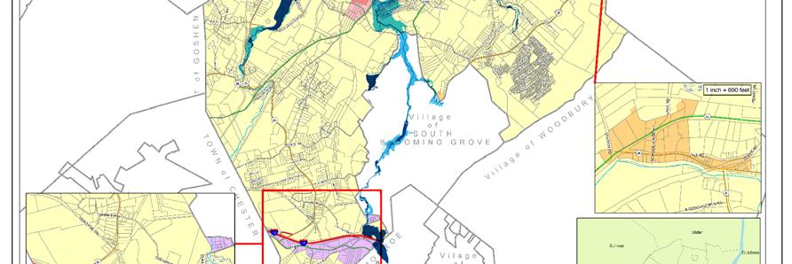
11 DRAINAGE MASTER PLAN A WATERSHED SCALE STUDY STUDY AREA: Analysis at the Moodna Creek Watershed scale encompassing the three municipalities Includes the Moodna Creek and its main tributaries: Cromline Creek Otter Kill Satterly Creek Perry Creek SCOPE: Field Reconnaissance and Survey Hydrologic and Hydraulic Modeling Identification of Flood Mitigation Projects and Recommendations Project Evaluation and Prioritization


12 DRAINAGE MASTER PLAN FIELD RECONNAISSANCE AND DATA COLLECTION DATA GAP ANALYSIS AND FIELD RECONNAISSANCE: 56 Bridges 48 Culverts 23 Dams 850 Stormwater Structures


13 DRAINAGE MASTER PLAN FIELD SURVEY surveyed assets including bridges, dams, culverts, stormwater assets and bathymetric data


14 DRAINAGE MASTER PLAN AN INTEGRATED, REGIONAL MODELING APPROACH Riverine Modeling Hydrologic Modeling Stormwater Modeling


15 DRAINAGE MASTER PLAN HYDROLOGIC MODELING Precipitation Data NOAA Atlas 14 (2015) Integration of Climate Change Risks Human activities are affecting the Earth s climate through greenhouse gas emissions and large scale land use changes. Climate change models predict that climate change will likely continue through the 21 st century. It is important to understand the regional impacts of climate change to design safe infrastructures and policies.

16 DRAINAGE MASTER PLAN HYDROLOGIC MODELING Rainfall/Infiltration Modeling using Geographical Information System Technologies Moodna Creek Watershed Digital Elevation Model Hydrologic Soil Type Land Use and Land Cover

17 DRAINAGE MASTER PLAN HYDROLOGIC MODELING Hydrologic Modeling Output Rainfall/Infiltration Processes Hydrologic Analysis River flows


18 KEY NATURAL FACTORS THAT CONTRIBUTE TO FLOODING Low Lying Areas & Water Bodies Surface and Soil Permeability Contributing Drainage Areas Steep Slopes
 Data source:")

19 DRAINAGE MASTER PLAN HYDRAULIC MODELING Riverine Modeling Based on High Resolution DEM High Resolution Digital Elevation Model (DEM) Data source: United States Geological Survey Release date: January 2016 Vertical accuracy: 0.7 feet Horizontal accuracy: 3.2 feet Village of Washingtonville Mays Field

20 DRAINAGE MASTER PLAN STORMWATER MODELING Modeling Stormwater Assets in the Village of Washingtonville Area modeled stormwater features including catch basins, conduits, outlets and culverts Modeled Area: 3000 acres

21 DRAINAGE MASTER PLAN STORMWATER MODELING Modeling Stormwater Assets in the Village of South Blooming Grove Area modeled stormwater features including catch basins, conduits, outlets and culverts Modeled Area: 400 acres


 USGS Stream Gauges")
 WSP PB Rain")
22 DRAINAGE MASTER PLAN MODEL INTEGRATION AND CALIBRATION Data collection for model calibration Gauge Locations OCWA Stream Gauges ( ) USGS Stream Gauges ( ) WSP PB Stream Gauges (2016) WSP PB Rain Gauges (2016)

23 DRAINAGE MASTER PLAN HYDRAULIC MODELING Simulated 100 year flood event in 2060s in the Village of Washingtonville

24 FLOOD RESULTS: WHAT DOES THE MODEL TELL US? 5, 10 and 100 Year Flood in 2060s

25 FLOOD RESULTS: WHAT DOES THE MODEL TELL US? 100 Year Flood in 2060s vs. Hurricane Irene Flooding

26 FLOOD RESULTS: WHAT DOES THE MODEL TELL US? 100 Year Flood in 2060s vs. FEMA 100 Year Flood Extent
27 KEY STRATEGIES AND RECOMMENDED PROJECTS
28 FLOOD MITIGATION STRATEGIES A comprehensive multifaceted approach that reduces flooding in the Town and Villages and preserves, strengthens and enhances the Community s environment: Store and Delay Restore Connectivity Drainage Improvements and Stormwater Management Protect Planning and Policies


29 FLOOD MITIGATION STRATEGIES 1) STORE AND DELAY The use of existing infrastructure, such as increasing the storage capacity of reservoirs, to capture and hold rainwater for flood prevention downstream.


30 FLOOD MITIGATION STRATEGIES 1) STORE AND DELAY: WILLOW BROOK DAM MODIFICATION PROJECT AND LAKE MANAGEMENT PLAN Project Overview: The Project consists of installing a crest gate system on the spillway section of the Dam and developing a Lake Management Plan Main Benefits: Reduce flooding in areas downstream from the Dam Prevent overtopping of Museum Village Road Proposed Gate System at Dam s Spillway Estimated Cost: $699 K Location: Lake Management Plan


31 FLOOD MITIGATION STRATEGIES 2) RESTORE CONNECTIVITY The removal of bottlenecks on identified key waterways to restore natural riverine systems and reverse the negative flooding effects caused by these blockages on adjacent communities.


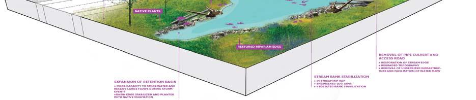
32 FLOOD MITIGATION STRATEGIES 2) RESTORE CONNECTIVITY: MAYS FIELD DAM REMOVAL PROJECT Project Overview: Remove Mays Field Dam and restore the hydraulic capacity of the Moodna Creek Before Main Benefits: Reduce flooding upstream of the dam in the Village of Washingtonville Eliminate risks of dam failure Restore aquatic connectivity Estimated Cost: $219 K Location:


33 FLOOD MITIGATION STRATEGIES 3) DRAINAGE IMPROVEMENTS AND STORMWATER MANAGEMENT Outdated and undersized infrastructure can contribute to significant amounts of water build-up. Increasing their capacity is critical for reducing flooding.


34 FLOOD MITIGATION STRATEGIES 4) DRAINAGE IMPROVEMENTS AND STORMWATER MANAGEMENT IN THE VILLAGE OF SOUTH BLOOMING GROVE Project Overview: Replacement of Route 208 Culvert and redesign the existing detention pond Before Main Benefits: Reduce flood damages Prevent road overtopping and enhance public safety Reduce economic losses Estimated Cost: $1.4 M (2 culverts) Location: After After


35 FLOOD MITIGATION STRATEGIES 4) PROTECT The use of physical flood protection measures, such as constructed berms, to ensure a reduction in flood damages.


36 FLOOD MITIGATION STRATEGIES 4) PROTECT: BARNES ROAD LEVEE PROJECT Project Overview: Construct a Levee along the Satterly Creek to protect the Barnes Road Development Flood Level 100 yr. flood event Normal Level Main Benefits: Protect homes and the Tappan Hill Waste Water Treatment Plan Reduce flood insurance premiums Estimated Cost: $3.5 M Location: Before After
37 FLOOD MITIGATION STRATEGIES 5) PLANNING AND POLICIES


38 POTENTIAL PROJECTS AND RECOMMENDATIONS PROJECT MAP 1 A 2 3 B C

39 FLOOD MITIGATION PROJECT EVALUATION AND SELECTION FRAMEWORK Our in house evaluation and selection framework tailored to the Project s goals and objectives is used to prioritize the flood mitigation projects Our selection procedure is based on both qualitative & quantitative criteria (BCA, NPV etc.)


40 FLOOD MITIGATION PROJECT EVALUATION AND SELECTION FRAMEWORK Financial Analysis (Benefit Cost Analysis, Net Present Value, etc.) A data driven prioritization process
41 NEXT STEPS: PATH TOWARDS PROJECT IMPLEMENTATION


42 NEXT STEPS: PATH TOWARDS PROJECT IMPLEMENTATION Awarded HUD CDBG DR funding: Town of Blooming Grove: $3.5 M Village of Washingtonville: $3 M Project Timelines Critical Path: Model developed Project Prioritization


43