Spur Hill Underground Coking Coal Project. Groundwater Assessment for Gateway Application. Tuesday 16 June 2015
|
|
|
- Donna Nicholson
- 5 years ago
- Views:
Transcription


1 Spur Hill Underground Coking Coal Project Groundwater Assessment for Gateway Application Tuesday 16 June 2015
2 HydroSimulations 2 Track record in groundwater assessment and modelling for water resources, mining and infrastructure applications. Substantial experience in modelling underground mines in NSW and QLD. Will Minchin 12 years experience in water resource assessment and groundwater impact assessment. Involvement in multiple EIS for mines and quarries in a variety of environments in NSW, QLD and VIC. Provided expert testimony for irrigators, water regulator and local govt. Dr Noel Merrick 40 years experience in groundwater science. Former Associate Professor at UTS, Director of the National Centre of Groundwater Management. Co-author of original Groundwater Modelling Guidelines (MDBC, 2001).
3 Overview 3 Current study status. Overview of hydrogeology and baseline data collection. Basics of groundwater modelling. Impacts of underground mining. Preliminary groundwater assessment for Gateway Application. Groundwater modelling approach for EIS. Potential management strategies.
4 Study Status 4 Baseline Data collection Conceptual Groundwater Model Development Simplified Numerical Groundwater Model Gateway Application (focusing on highly productive groundwater) Develop higher resolution Numerical Groundwater Model Final Groundwater Assessment for EIS (comprehensive assessment)

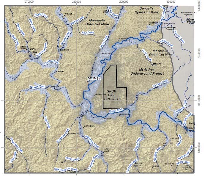
5 Project and Regional Area 5


6 Geology 6 Whynot Bowfield Warkworth Crosssection: H.R Newcastle Wittingham
7 Hydrogeology 7 Two major hydrostratigraphic units : Hunter Alluvium. o Highly connected with Hunter River. o classified by NSW Office of Water as a highly productive groundwater source. Sydney Basin Permian rock units. o associated with Newcastle and Wittingham Coal Measures. o coal seams are the more permeable sub-units. o classified by NSW Office of Water as of less productive, i.e. low resource potential.
8 Mt Ogilvie Structure: historical interpretation 8 Mapped on Hunter Coalfield Geology Map (2 nd ed, 1993) as a fault Displacement ~ m Cross-section: Fault However that not based on local data (i.e. around SHM lease); SHM have field work and analysis by geoscience consultants: Geophysical Resources & Services (GRS) and by McElroy Bryan Geological Services (MBGS)

9 Mt Ogilvie Structure: revised understanding at Spur Hill Conceptual model: north of Hunter R.? i.e. possible fault / barrier Fault 9 MBGS & GRS (2014): There is no evidence for the existence of a continuous fault (Mt Ogilvie Fault) as shown on the 1993 Hunter Coalfield Geological Map, within and adjacent to EL That structure may exist north of Hunter River and between Mangoola Mine and Bengalla Mine, but SHM do not have access to geological data from that area that could provide an indication of the existence and nature of such a fault?? Conceptual model: south of Hunter R. Monocline or roll-over
 (data from 2001) Water level and")
10 Baseline Groundwater Data Collection 10 Packer testing (SHD005 and SHD010) Permeability testing of core samples (80 samples) Alluvial transects in north-west and south-west Transient electromagnetic survey Multi-level vibrating wire piezometers Water level and quality monitoring in alluvial transect bores NSW Office of Water real time monitoring bore (alluvium) (data from 2001) Water level and quality monitoring bores (coal measures) (installed late 2014)
11 Basics of Groundwater Modelling 11 The real world = complex Simplified major processes representative permeabilities Spitz & Moreno, 1996

12 Basics of Groundwater Modelling 12 Mathematical representation of: Topographic Geological surfaces Creek level Springs Mine workings etc. History matching Groundwater levels fluxes Modelled flux Spitz & Moreno, 1996

13 Basics of Groundwater Modelling What would happen if a bore pumped from a certain location? 13 e.g. a farmer s bore What would happen if an open cut pit was excavated? What would happen if an underground mine was operated? e.g. some surrounding mines e.g. Spur Hill What changes? how much drawdown? change to flow direction? reduced baseflow to creeks/rivers? licensing requirements What would happen cumulatively?

 highly connected cracking regime becoming less connected with increasing height above seam.")
14 Impacts of Underground Mining 14 Ditton (DGS) zone D-zone (surface cracking) surface subsidence surface subsidence Surface water C-zone (dilated, upper) B-zone (dilated, lower) surface cracking regime vertical fractures of limited depth disconnected cracking dominantly bedding plane shear with occasional reactivation on pre-existing joints negligible enhancement to vertical permeability but horizontal permeability may be enhanced undisturbed strata beyond angle of draw Water in this zone goes in storage in dilated rock mass Temporary drop, recovers as storage as filled or dilation closes as mining passes through and beyond A-zone (continuous cracking) highly connected cracking regime becoming less connected with increasing height above seam. Enhanced vertical permeability promotes depressurisation of strata goaf total failure and roof detachment gives highly fragmented regime (high permeability and porosity) Height of relatively free drainage water enters this zone, drains into mine goaf water enters mine workings Coal seam Coal seam NOT TO SCALE panel width (w) Modified from NSW Government Department of Planning (2008) Geomechanical changes NOT TO SCALE panel width (w) Modified from NSW Government Department of Planning (2008) and Kendorski (2006). Groundwater response
15 Multi-Seam Interactions 15 Lots of work by many authors to understand effects of single-seam longwall extraction. Less on multi-seam extraction, but the industry has experience of this, e.g. other multi-seam mines in the Hunter Coalfield include: o North Wambo Underground o Blakefield South Mine o Ashton o Newstan Ditton Geotechnical Services (DGS) is providing advice to SHM on height of A- and B- zones fracturing above longwalls in a multi-seam mine.
16 Gateway Modelling Requirements 16 Provide estimates of all quantities of water that are likely to be taken from any water source during and following cessation of the activity and all predicted impacts associated with the activity. if the Gateway process applies, estimated based on a simple modelling platform that is: developed using the available baseline data that has been collected at an appropriate frequency and scale; and determined to be fit-for-purpose to the satisfaction of the Minister Source: Section 3.2.3, NSW Aquifer Interference Policy
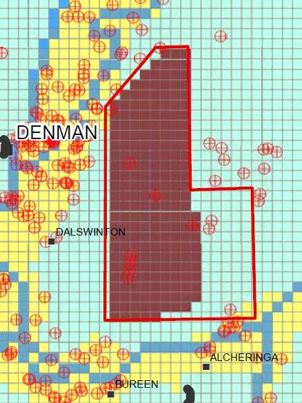
17 Key Conclusions of Gateway Assessment 17 NOTE: these to be revised based on EIS Assessment Groundwater take: Average 1230 ML/yr from Coal Measures (hard-rock) [peak 1750 ML/yr] Up to 6 ML/yr from Hunter Alluvium (< 0.01% of total licence allocation) Up to 17 ML/yr from Hunter Regulated Water Source (< 0.01% of total allocation) No High Priority Groundwater Dependent Ecosystems (GDEs) or Culturally Significant sites identified in the Water Sharing Plan. No change to beneficial use category in the hard-rock strata or Hunter Alluvium. No. of private bores identified as being impacted upon beyond the 2m threshold in the Aquifer Interference Policy: Hard-rock strata = 12 (13 bores considering cumulative impacts) Alluvium = 0
18 Key Updates to Groundwater Model for EIS 18 Aspect Model extent Model software Model complexity Cumulative impacts Action Model extended to the west Different (newer) modelling software Smaller model cells (following slide). More model layers: layers. Include all surrounding mines and approved projects in the numerical model: Mt Arthur Bengalla Mangoola Drayton South

19 EIS Groundwater Model Gateway 19 EIS
20 Outputs from Groundwater Model for EIS 20 Revised predictions of: Potential impacts on groundwater pressures* Potential alteration of groundwater flow direction* Potential impacts on private bores* Groundwater inflows to the underground workings Recommendations for licensing of groundwater take from Permian hard-rock and from Alluvium water sources. Time to recovery of groundwater levels* * project-specific and cumulative effects
21 Potential Management Strategies 21 Monitoring A Groundwater Management Plan will need to be developed by SHM and approved by various agencies. Currently monitoring alluvium and hard-rock water levels and chemistry around the mine lease. Two new monitoring bores (one NW and one SE) following advice by IESC. Groundwater Licensing Water Source Permian Rock (less productive) Hunter Alluvium (highly productive) Hunter regulated river SHM licence need to apply 125 units 1,222 units + 3 units (high security)
22 Potential Management Strategies (cont.) 22 Make good provisions for groundwater bores with >2 metres drawdown as required by the NSW Aquifer Interference Policy. Model Conditions for underground mines released by Department of Planning & Environment: Interim compensatory water supply (within 24 hr) Long-term compensation equivalent to loss attributable to the Project To be agreed between SHM and landholder Model conditions available at: underground mines
23