Regional Association VI, Forum Hydrology, Oslo, September 20-23, 2016
|
|
|
- Andrea Sullivan
- 5 years ago
- Views:
Transcription


1 Regional Association VI, Forum Hydrology, Oslo, September 20-23, 2016 Harmonization of monitoring network and of hydrological data processing on transborder rivers - Danube solution Water Informatics System for flood warning and environment protection Dr. Mary-Jeanne Adler, mj.adler@yahoo.com Hydrology Forum Oslo, September 20-23, 2016
2 Informational System for Danube Increase the capacity of cooperation and control Monitor the quality of environmental factors along the Romanian-Bulgarian Danube sector Create an integrated database for environment monitoring Set up a common interface for protection against floods and other calamities.
3
4 Environment Monitoring Module Support for real time environmental data collection and visualization Multiple data sources National Institute of Hydrology and Water Management (forecasts) Romanian Waters National Administration (water levels, water quality) National Environment Protection Agency (air quality, radioactivity) Romanian Naval Authority Bulgarian Partners GIS unified representation of data, trends, charts that help in management and decision support.


5 Public portal Internal portal Bulgarian Data Input Data Source SIM Integrated Environment System IIS WATER Data Base Input Data WIMS Water Management System ARQ Analysis for Water Quality Forecast module Geo-Referenced Information Environment monitoring module Decision support module RoRIS Romanian River Information Services SSN Safe Sea Net
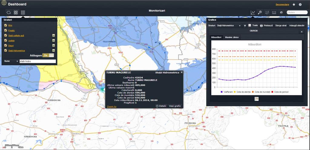
6 Monitoring Module
7 Monitoring Module Monitoring Module of the WATER-IIS main features are: Base maps, themes and layers that help for geo-referencing points of interest on the map Monitoring near real time data measurements (water level, water debit and forecasts) Representing information on high detailed graphics Map user interfaces features that help for analyzing information.
8 Decision support module System for Decision Support in case of environmental disaster Cross-border environmental emergency situations management Integration of data provided by the Environment monitoring module Alerting functions in case of a disaster Interventions resources management defense supplies (materials & equipment) Evacuation management in case of a disaster Hazardous materials monitoring to prevent ecological disaster
9

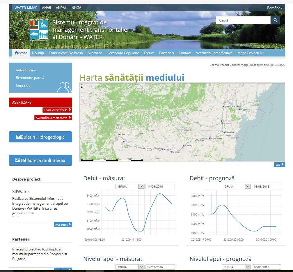
10 FORECAST MODULE One of the main result of the Danube WATER project is a real time common information system, data exchange program and common hydrological and water quality database, real time data flows and forecasting system, design and implementation of the interface for the dissemination of representative products.
11 FORECAST MODULE The models DANUBIUS hydrological model This hydrological routing model, developed within NIHWM, is used for the daily elaboration, with a 7 15 days anticipation, of the levels and discharges forecast on the Romanian sector of the Danube. This model is made up of a simulation model and a updating procedure of the simulated discharges. MIKE 11 software MIKE 11 HD provides an array of computational methods for steady and unsteady flow in branched and looped channel networks, and flood plains. The module AD can describe the concentrations of pollutants variable in space and time along the river dispersion coefficients. HEC-RAS model The U.S. Army Corps of Engineers River Analysis System (HEC-RAS) is a software that allows you to perform one-dimensional steady and unsteady flow river hydraulics calculations.
12 FORECAST MODULE The platform Delft-FEWS platform provides a state of the art system for integrating forecasting models, in order to build operational hydrological forecast and warning system. The system is a sophisticated collection of modules designed for building a hydrological forecasting system customized to the specific requirements of an individual organization The DELFT-FEWS is actively developed and maintained by DELTARES, Netherlands, and is also having well developed community of users.

13 The platform FORECAST MODULE
14 FORECAST MODULE Hydrological Forecasting Models improvements within the Danube Water Project DANUBIUS hydrological routing model reconfiguration to work with hourly time step (24 hours in the previous implementation). Increase of the DANUBIUS model forecasts lead time from 7 days to days. Design and implementation of the data interface with the new HFMS- DESWAT forecasting system, in order to incorporate as inputs the hydrological forecasts for the Romanian tributaries. Model reconfiguration to include the Danube main tributaries from Bulgaria. Update of the monitoring system, which includes new hydrometric automatic stations on the Romanian sector of the Danube River.
15 FORECAST MODULE Hydrological Forecasting Models improvements within the Danube Water Project Using hydraulic routing model for the common Romania Bulgaria sector of the Danube will allow more detailed and accurate hydrological forecasts for the water levels evolution, during the extreme events (floods and droughts). Within the hydraulic models, for the common sector, both main and secondary Danube tributaries from Bulgaria are incorporated. In case of accidental pollution the new implemented water quality models will provide the capability to faster analyze and simulate the pollution wave evolution downstream, estimate the concentration value and time to reach in different sections, and to faster issue alerts and warnings to local decision makers.

16
17