SECTION III LAND AND WATER RESOURCE INVENTORY
|
|
|
- Noah Benjamin Cunningham
- 5 years ago
- Views:
Transcription
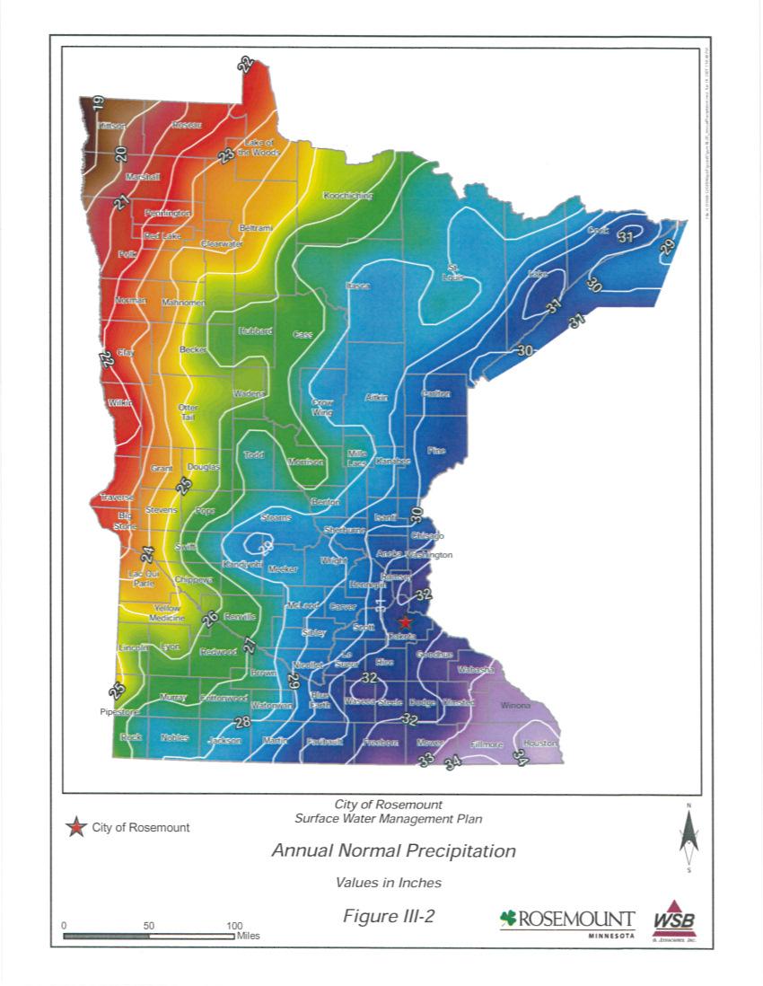
1 III. LAND AND WATER RESOURCE INVENTORY In conformance with the Metropolitan Surface Water Management Act and as required in Minnesota Rules Section , this section of the plan provides a general description and summary of the climate, geology, surficial topography, surface and ground water resource data, soils, land use, public utilities services, water-based recreation, fish and wildlife habitat, unique features, scenic areas, and pollutant sources. This section also identifies where detailed information can be obtained for many of these areas of concern. A. Climate and Precipitation 1. Climate The climate for Dakota County, just south of the Minneapolis/St. Paul metropolitan area is described as a humid continental climate with moderate precipitation, wide daily temperature variations, warm humid summers and cold winters. The total average annual precipitation is approximately 34 inches, of which approximately one-third occurs in the months of June, July and August. The annual snowfall average is about 44 inches and is equivalent to approximately 4.4 inches of water. Average monthly temperature and precipitation are shown in Table III Precipitation A rainfall event having a 99% chance of occurrence in a 24-hour period is approximately 2.4 inches. A rainfall event having a 1% chance of occurrence in a 24-hour period is approximately 6.0 inches. The 1%, 10- day runoff is 7.2 inches. Figures III-1 and III-2 show the 1% rainfall event and the annual normal precipitation within the State of Minnesota. Additional climatological information for the area can be obtained from State Climatologist website at B. Existing and Proposed Drainage Patterns Storm water runoff from the City is land-locked as the City has no positive outlet. The drainage in the City is characterized by a number of deep depressions. The majority of these depressions are landlocked, with no natural overflow out of the direct subwatershed of the basin. The specific drainage areas, which depict topography for areas within the City, are shown on the subwatershed delineation map on Figure III-4 and are further illustrated in the stormwater trunk system map in Appendix B. As can be observed from the subwatershed delineation map, the City is divided into many small watersheds. The subwatershed delineations, identified in Figure III -4, utilized City topographic mapping, storm sewer as-builts, and have been further delineated to include the direct tributary subwatershed for many of the larger basins within the City. The proposed drainage pattern will include storing the 100-year, 24-hour storm event for new development. A temporary storm sewer trunk overflow system will be constructed to the east as part of the proposed MCES treated effluent outfall to provide overflow capacity if needed to the Mississippi River. As development City of Rosemount Section III Page 1
2 occurs, the City anticipates construction of a permanent stormwater trunk conveyance overflow system to the east located adjacent or near the proposed MCES outfall route. C. Geology and Topographic Information 1. Geology: The City of Rosemount is located in north central Dakota County (Figure III-3). Total area within the corporate limits is approximately 35 square miles. The northeastern boundary of the City is the Mississippi River. The City of Apple Valley borders to the west, while Eagan and Inver Grove Heights are to the north. The City of Coates, along with Empire and Vermillion townships border Rosemount to the south. Nininger Township borders to the east, in the areas where the Mississippi River does not. The two major geomorphic regions within the City are moraine topography and valley outwash. The Mississippi Valley Outwash Area is located along an approximate line from the southwestern part of the City to the northeast corner. This area was formed from the water associated with melting glaciers. The area appears as nearly level terraces and floodplains. On the higher terraces water tables are usually deep and in the low terraces water tables are shallow. The remaining part of the City is within the Eastern St. Croix Moraine geomorphic area. The area consists of relatively steep hills, rolling topography and some deep depressions that are filled with small lakes or peat. The area consists of a mixture of red and grey till and is composed of silt, clay, sand, pebbles, cobbles, and boulders. Water tables may be at or near the surface in the depressions, but are 10 feet or deeper in the hills. Based on the Dakota County Geologic Atlas, depth to bedrock within the City ranges from less than 50 feet in parts of eastern Rosemount to 250 feet in western Rosemount. The bedrock along the Mississippi River is between feet below the surface. Bedrock formations include the St. Peter Sandstone and Prairie du Chien group with Jordan Sandstone and Franconia Formation near the Mississippi River. The City also contains an area in the east known as Rich Valley. Rich Valley is a covered karst valley. There are approximately 50 feet of outwash sand and gravel sediments that overlie the fractured and cavernous Prairie du Chien s dolostones and sandstone. Additional geologic information for areas within the City can be found in the following plans: Dakota County Geologic Atlas Vermillion River Watershed Joint Powers Organization City of Rosemount Section III Page 2
3 TABLE III-1 AVERAGE MONTHLY TEMPERATURE AND PRECIPITATION DATA FOR CITY Months Average Temp (F ) Precipitation (inches) Snowfall (inches) January February March April May June July August September October November December Totals Source: Midwestern Regional Climate Center, Rosemount City of Rosemount Section III Page 3
4
5

6
7 2. Topography: The topography of the City can be described as rolling, with short, steep slopes and numerous depressions. The slopes become longer and more gradual towards the east. The northeastern corner is characterized by river bluffs sloping to the Mississippi River. D. City Surface Water Resource Data Available surface water resource data within the City is summarized in this section. Detailed information has been included either in the appendices to this report or has been identified by reference and is available from the Engineering Department. The hydrologic system of the City consists of wetlands, streams, and major water bodies as outlined below. 1. Wetlands The general locations of wetlands within the City are shown on Figures III-5-6 and III-16. These figures show the National Wetland Inventory and the DNR Public Waters Map and Wetland Functional Assessment as identified in the City Comprehensive Wetland Management Plan. These wetlands provide habitat to many species of plants and animals. 2. Major Bodies of Water There are several major water bodies that convey and store water within and through the City. These water bodies are the Mississippi River, Keegan Lake, White Lake, Birger Pond, Schwartz Pond, Wachter Lake, and many other unnamed water bodies (Figure III-6). More information about these water bodies in included in various portions of this section. The Vermillion River Watershed Wetland and Watercourse Inventory and Assessment within the City of Rosemount is shown in Figure III -15. This figure shows the wetland and waterway classifications as defined by the DSWCD. 3. Hydrologic Modeling (Water Quantity) The City s hydrologic/hydraulic system consists of several land-locked depressions as the City has no positive surface water outlet. As part of this Surface Water Management Plan, the City has developed a trunk storm water system outlet plan that will direct surface water to the Mississippi River. This proposed system in shown in Appendix B. The City is divided into 15 subwatershed areas as shown in Figure 4. A Hydrocad model has been developed for the following subwatersheds: City of Rosemount Section III Page 7
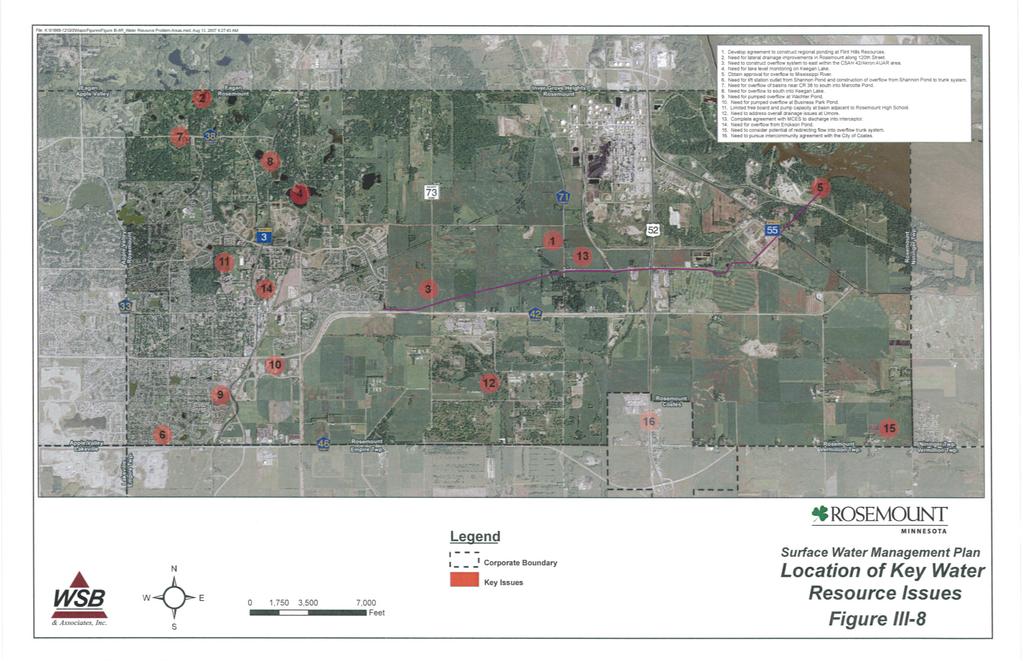
8 1) Birger Pond District 2) Coates District 3) East Rich Valley District 4) Erickson Pond District 5) Hawkins Pond District 6) Keegan Lake District 7) Koch District 8) Lebanon Hills District 9) Mississippi River District 10) Shannon Ponds District 11) U of M East District 12) U of M West District 13) Wachter Pond District 14) West Rich Valley District 15) White Lake District The hydrologic/hydraulic modeling effort quantifies the peak discharge rates, outlet elevations, and other pertinent hydrologic/hydraulic information for storm water retention areas, and trunk storm water conveyance systems within the City. A summary of the modeling results and more detailed drainage system map is included as Appendix B. E.. Flood Insurance Studies A Federal Emergency Management Agency (FEMA) Flood Insurance Study (FIS) was completed for areas within the City in The Flood Insurance Study consists of a study report, a set of floodway and floodplain delineation maps, and a set of Flood Insurance Rate Maps (FIRM) maps. The FIRMs are available from the City Engineering Department. The floodplain boundaries for the City are shown in Figure III-7. The 100-year flood levels and peak discharge rates based on the City s model are included in Appendix B. F. Locations of Key Water Resource Issues A number of water resource issues / problems were identified within the City. Figure III-8 shows the locations of these key water resource issue areas which have a specific geographic location. These areas were identified through information obtained from City Advisory Committees and City Staff. City-wide policy issues and problems have been listed in section IV but have not been include in Figure III-8. More detailed information about these issues is available in Section IV of this Plan. City of Rosemount Section III Page 8
9 G. Water Quality Data 1. Overview Water quality data for the City has been obtained from the MPCA s Environmental Data Access site at This database is utilized by participating agencies to compile water quality testing data and is almost entirely used for the storage of water quality parameters. Figure III-9 shows the location of monitoring sites listed on the MPCA web-site. Some of the available water quality information is summarized below: Mean Total Phosphorus (ppb) Mean Chlorophyll a (ppb) Secchi Disk (meters) Carlson Trophic Status Mississippi River Hypereutrophic 2006 List of Impaired Waters (Section 303d): The Minnesota Pollution Control Agency lists the following waterbodies/water courses within the City as having impaired uses due to excess pollutant(s): Mississippi River (Mercury, PCB, Turbidity) The Mississippi River is designated as having a Total Maximum Daily Load (TMDL) for acceptable levels of those pollutants. Sediment containing phosphorus and turbidity are two of the many reasons for impairment. As of 2006, the EPA has not approved a study or TMDL implementation plan for reducing pollutant levels to the Rosemount portion of the Mississippi River. Figure III-9 also shows the location of the impaired waters. 2. Water Quality Modeling Data Water quality data for the City has been obtained from the Storage and Retrieval Database (STORET) water quality database, which is available through the Minnesota Pollution Control Agency (MPCA). This database is utilized by participating agencies to compile water quality testing data and is almost entirely used for the storage of water quality parameters. City of Rosemount Section III Page 9
10 Monitoring data is available for the following area in the City of Rosemount: Spring Lake (DNR ) Average TP=267 ppb Average chl a=28.1 ppb Mean Secchi = 0.3 meters TSI = 75 H. Floodplain Management The City has adopted a Floodplain District to provide floodplain management for the City. A copy of these regulations can be found on the City s website at The intent of the floodplain district is to reduce risk to public health, property, and general welfare. These regulations prohibit uses or activities within the floodplain or floodway that include structures or fill or that obstruct flood flows or cause increased flood elevations. I. Shoreland Management The City has adopted Shoreland Overlay Regulations. The purpose of these regulations is to protect shoreland areas to preserve and enhance surface waters. A copy of these regulations can be found on the City s website at Based on these regulations, the City has classified the following DNR Public Waters/Wetlands: Water Body No. Water Body Name Classification 19-8 Unnamed Natural Environment 19-9 Unnamed Natural Environment Unnamed Natural Environment Unnamed Natural Environment 19-5 Mississippi River General Development Keegan Lake Recreational Development Figure III-6 shows the location of these water bodies with the Ordinary High Water (OHW) level, if applicable. J. Ground Water Appropriations Within the City, ground water wells serve the City and private water needs. Each of these wells has a ground water appropriation permit from the DNR. Figure III-10 shows the types and locations of ground water well sites within the City. K. Ground Water Resource Data Ground water resource data for areas within the City is contained within the Dakota County Geologic Atlas and the City s Wellhead Protection Area Delineation report (Barr, 2002). The primary aquifers within the City of Rosemount consist of the Prairie du Chien and Jordan aquifers. Information from the Geologic Atlas and Wellhead Protection Plan indicate that the aquifers in Rosemount and Dakota County generally flow to the northeast. This would indicate that Rosemount s groundwater primarily discharges to the Mississippi River. City of Rosemount Section III Page 10
11 Three wellhead protection areas have been identified by the City. Two of these areas are located in the western portion of the City and one area is located in the eastern portion of the City. L. Soils Information The soils within the City area generally have high infiltration rates and are susceptible to erosion. The hydrologic soil groups map is shown in Figure III-11. The four soil classifications are defined as follows: Group A - These soils have high infiltration rates even when thoroughly wetted. The infiltration rates range from 0.3 to 0.5 inches per hour. These soils consist chiefly of deep, well drained to excessively drained sands and gravel. Group A soils have a high rate of water transmission, therefore resulting in a low runoff potential. Group B - These soils have moderate infiltration rates ranging from 0.15 to 0.30 inches per hour when thoroughly wetted. Group B soils consist of deep moderately well to well drained soils with moderately fine to moderately coarse textures. Group C - These soils have slow infiltration rates ranging from 0.05 to 0.15 inches per hour when thoroughly wetted. Group C have moderately fine to fine texture. Group D - These soils have very slow infiltration rates ranging from 0 to 0.05 inches per hour when thoroughly wetted. Group D soils are typically clay soils with high swelling potential, soils with high permanent water table, soils with a clay layer at or near the surface, or shallow soils over nearly impervious material. The soils in the northwest and north central part of the City are from the Kingsley- Mahtomedi series and are characterized as gently sloping to very steep, loamy, and silty textured soils. The Waukegan-Wadens-Hawick association, which is common in the northeast and southern portion of the City, is defined as level to very steep, silty, loamy, and sandy textured soils. Additional information on the soil for the City is available in the Dakota County Soil Survey available at City Hall. M. Land Use and Public Utilities Services The City s land use practices include residential, commercial, industrial, agricultural, and public and private open space areas. Figure III-12 is a representation of the existing land use. Figure III-13 shows the future land use. Most of the residences and businesses in the City are served by public water and sewer systems. The City does, however, contain some Individual Sewage Treatment Systems (ISTS). Some of these sites are anticipated to be abandoned and converted to city services in the next years. City of Rosemount Section III Page 11
12 N. Public Areas for Water Based Recreation and Access There are a number of water bodies that offer passive recreation such as walking, hiking, and bird watching. Spring Lake Park Reserve is a County Park located in eastern Rosemount, and is adjacent to the Mississippi River. There are no public water accesses within the City. O. Fish and Wildlife Habitat The City provides habitat for a variety of small mammals, reptiles, birds, amphibians, and insects. Maintenance of habitat for wildlife species is important in maintaining ecological stability of the City s natural areas. The wetland inventory found in the City s Comprehensive Wetland Management Plan, amended December 2005, (Appendix F) assesses a number of wetland functions such as floral diversity, wildlife habitat, and fisheries habitat for each wetland. Based on the information from the Minnesota County Biological Society and Natural Heritage Database, there are a variety of unique wildlife habitats and rare species within the City, much of which are located along the Mississippi River. The wildlife habitat along the River consists of Oak Forest-Dry subtype, Floodplain Forest- Silver Maple Subtype, and Dry Prairie-sand-gravel subtype. Other habitat in the City consists of Oak forest mesic subtype and Tamarack swamp. A number of rare or endangered species have been noted in the City including Blanding s turtles, Gopher snake, Fox snake, Red-shouldered hawk, and Loggerhead shrike. The endangered plant James polanisia has been noted near the River. The Mississippi River is the primary source of fish habitat in the City. Information from the DNR indicates that no fish stocking occurs within the water bodies in the City. P. High Value Natural Areas, Unique Features and Scenic Areas Unique features and scenic areas include State designated Scientific and Natural Areas, designated scenic areas, areas containing rare and endangered species, biologically diverse areas, and historic areas. The City has many natural areas, water bodies, and city/regional parks. Some of these areas contain rare and endangered species and special habitats as indicated above. The City has no Scientific and Natural Areas or wild and scenic rivers as defined by the State. The City does have a number or historical and architectural resources as identified by the Minnesota State Historical Preservation Office. The sites and locations of these resources can be found in the Water Resource Library. City of Rosemount Section III Page 12
13 High Value Natural Areas are habitat areas beyond the buffer standards and wetlands protections that are strongly recommend by the VRWJPO to be protected during development. The Sensitive and Natural Areas as identified in Figure 1-12 of the VRWJPO Plan has been incorporated into Figure III-15 of the Plan which includes the locations of the High Value Natural Areas, the Minnesota National River and Recreation Area, and the Dakota County Regional Park within the City. The City will consider policies related to the conservation of these sensitive and natural areas including the identified High Value Natural Areas during development of the City s Comprehensive Land Use Plan consistent with Metropolitan Council requirements. Q. Polluant Source Locations Information from the MPCA is shown on Figure III-14. This figure shows the approximate locations of a variety of pollutant sites. Many of the sites on the figure have been cleaned up or are in the process of being cleaned up. The MPCA should be contacted for site-specific details. R. NPDES Phase II The Minnesota Pollution Control Agency (MPCA) implemented the National Pollutant Discharge Elimination System (NPDES) Phase II Stormwater Program in March Phase II requires municipal separate storm sewer systems (MS4's) in urban areas with populations over 10,000 and under 100,000 to obtain an NPDES permit. Permits for construction sites greater than one acre are also required as part of the Phase II. The City has submitted its Stormwater Pollution Prevention Plan in conformance with the MPCA guidelines. The application that was sent to the MPCA is included in Appendix L. City of Rosemount Section III Page 13
14
15
16
17
18