Developing a Texas Preferred Ike Dike/Coastal Spine
|
|
|
- Merryl Morrison
- 5 years ago
- Views:
Transcription

1 Developing a Texas Preferred Ike Dike/Coastal Spine
2 Planning Environment Time All truth passes through three stages. First, it is ridiculed. Second, it is violently opposed. Third, it is accepted as being self evident. Arthur Schopenhauer
3 Planning Environment Process USACE with local sponsor GLO now clearly in charge of designing and building coastal protection Completed a study using expected surge threat to develop options and select the best option USACE announced its Tentatively Selected Plan (TSP) on Oct 26 Plan basically Coastal Spine/Ike Dike with some add ons Public comment period (75 days), ends Jan 9 th don t expect much from meetings USACE will take comments and perform more detailed analysis but focused on finalizing the option outlined in the TSP Final plan out in 2021 Construction , Operational
4 Status and Strategy STATUS Between steps 2 and 3 time wise Moving rapidly towards widespread acceptance Formal process now controlling STRATEGY Act like self evident Avoid arguments Point out no viable alternative Support developing best Coastal Spine possible Use TAMUG/Dutch/Jackson State experience from a decade of studying Ike Dike Mindful USACE in charge Costs need to be right funding still not well developed
5 TAMUG Approach to USACE and Public Focus on USACE report ignore others? Technical arguments wherever possible In presentation Summary of USACE TSP Identify issues and what s needed to make the TSP better for Texas Discuss each issue separately, point out some connections On website Overview white paper Summary of each issue and technical back up where available
6

7 Alternative A Coastal Barrier/Non Structural System


8 TAMUG/Dutch Plan
9 Agree with Strategic Finding But Spine Can Be Made Better for Texas/Region We agree strongly with the COASTAL TEXAS PROTECTION AND RESTORATION STUDY s Draft Integrated Feasability Report and Environmental Impact Statement s principal finding that a coastal spine/ike Dike is the best option for primary surge protection for the Galveston Bay Region However, we believe that some aspects the coastal spine design advanced by the USACE can be modified to better integrate the coastal spine into the economic, environmental and social fabric of the Texas Coast. We urge that the USACE consider our suggested modifications to their TSP when forming their final plan in 2021.
10 Suggested Changes To USACE TSP
11 Add a western section on Follets Island and gate San Luis Pass Leaving San Luis Pass (the back door) open allows fore surge and surge into the Bay system Compromises the basic Ike Dike strategy of keeping water out of the Bay Disallows reducing water level on hurricane onset by closing Bay at low tide TAMUG/JSU Modeling of 8 representative storms shows higher surge, especially near west Galveston Island No USACE modeling with and without western protection USACE argument to leave San Luis pass ungated not technically based
12 USACE in their own words A closure at the natural pass at the west end of Galveston Island is not recommended as part of the TSP. The anticipated risk reduction benefits do not outweigh the potential negative environmental impacts of closing off the last remaining natural pass along the Texas coast. Several factors contribute to the low benefit stream. Many of the structures and assets that would be protected as a result of the closure are already elevated above surge heights or are at a ground elevation that limits surge impact. There is also limited surge risk when factoring in the full probability of potential storm directions. Finally, the pass and the adjoining West Bay are very shallow and constitute only 10 to 12 percent of the water exchange between West Bay and the larger area of Galveston Bay. This condition minimizes the risk of surge being transmitted to the larger area of Galveston Bay where there is a greater number of structures and assets at risk from storm surge.
13 Request of USACE re Western Section Critical to get this right affects surge and fore surge, which in turn affect structure design including ring levy and Clear Creek, Dickinson bayou structures Use TAMUG/JSU modeling results and do more modeling with pass gated and open to develop quantitate arguments Natural pass argument confusing in view of bridge effects and silting issues If gate appearance an issue use inflatables
14 Move the West Galveston Island and Bolivar Land Barriers to the Coast as fortified dunes 1 Near coastal highways leaves those on seaside exposed to more surge risk Requires takings of private property and wetlands Requires numerous road gates each a source of potential failure Property value/tax base lost on west end Galveston /Bolivar? Higher Insurance rates as opposed to being behind barrier.
15 USACE Land barrier generally placed behind highways on Bolivar and West Galveston Island Described in USACE as text Environmental organizations have FOIed GIS Shape files and placed on Google maps: see for example According to analysis by Bevington using the maps 1,817 total property parcels that directly intersect with the levees 12,664 parcels (worth approximately $2 billion) on the floodsideof the USACE proposed levee (Galveston Is. and Bolivar)
16 Wording in USACE report On its page 14 the USACE report states, For planning purposes for the DIFR EIS, the team evaluated a levee/floodwall system across Bolivar Peninsula and Galveston Island; however, the team recognizes that there are opportunities to optimize the design and alignment to minimize impacts to existing structures and the environment on the peninsula and island. Future design efforts would focus on where engineered dune systems may be appropriate versus levees and floodwalls.
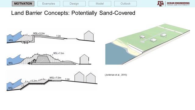
17 Move the West Galveston Island and Bolivar Land Barriers to the Coast as fortified dunes 2 Barrier in dune approach will work see work by Figlus, others On beach no takings, no disturbing wetlands T wall, clay and sand seems reasonable Need to maintain beach! Applaud USACE TSP plans for beach and dune nourishment for Bolivar, Galveston Island and Follets Island Stop erosion if not now, when Otherwise Sea wall from San Luis pass to High Island


18 Jens Figlus Work Hybrid Structures

19
20
21

22

23

24
25 Delay or scrap the Eastern Barrier N/S Eastern Barrier near High Island isn t cost effective More recent TAMUG modeling shows that run around waters pushed into the eastern Bay by surge are mitigated by lower Bay levels associated with easterly winds experienced before the storm s arrival
26 Rethink and modify the Ring Barrier on Galveston s East End Many points of failure 46 2 lane highway gates, 6 4 lane highway gates, 4 railroad gates, 3 pumping stations Nightmare overflow scenario Disrupts port operations, divides neighborhoods Developed for USACE Options with it as primary protection for City Kept in at size Needed? if so how high major surge versus nuisance flooding Was in all non spine options as sole protection with spine not as critical

27 Map ring Levee
28 Consider Reducing the size and impacts of the gates at the Bolivar Roads Barrier Height of water barrier (18ft) versus land barrier little lower might make sense Ship gates floating sector back flow protection? Very Large 1200ft width depth of channel 60ft Environmental gates ft wide vertical lift gates one recreational gate Barrier flow Salinity reduction estimates 2ppt, S reduction good thing? If more openness or more flow desired consider inflatables on eastern portion or replacing some lift gates with barge gates Design to taking advantage of an active barrier for example, opening gate(s) after the storm passes the coast to reduce the effects of backflow on Galveston Island?

29

30
31 Bay add on protection requires comprehensive system in addition to gates at 17ft Bay add ons Needed? Like Ring Levy essential for other USACE options Left in at large size needed with Coastal Spine? Gating at Kemah Shoreacres alternate surge path Dickinson Bayou Complicated many alternate paths
32 Costs USACE cost estimate for upper coast protection is $14,170,440,000 to $19,871,300,000. $31B is used often but that is for whole coast Compares with GCCPRD cost estimate of $9.5B for a similar design and $9.2B from a Dutch Study that included a Western section on Follet s Island and gating San Luis Pass but no ring barrier or in Bay gates In process of comparing estimates and generating independent analysis by Dutch experts Again, critical to have good costs for any plans to acquire construction monies
33 Summary USACE Plan right overall strategy Can be made better for Texas and local communities Our collective role supply best ideas and analysis and support USACE in their efforts to do that Goal is to develop best possible coastal spine one that not only provides needed surge protection but also fits into the economic, environmental and social fabric of our coastal communities
34
35 TAMUG Ike Dike Activities Extended Economics Insurance effects Texas Preferred Plan Modifications to USACE TSP Possible changes to present protection system
36 Insurance Effects Depending on the intensity of the storm, residents in the Houston-Galveston Area would save between approximately $15 and $18 million per year in federal flood insurance premiums. A coastal spine would reduce individual insurance premiums between approximately $600 and $1,000 per policy annually. Note New Orleans Experience
37 Economics Basic Cost/Benefit excellent for spine from all sources Latest Additional Benefits for Typical Economic Growth Scenarios Gross State Product (GSP) in TX is 8.15% lower without coastal protection vs. 2.06% with coastal spine. US GDP is 1.10% lower without protection vs. 0.30% with protection. Per capita income in TX declines by 1.8% without protection vs. 0.3% with coastal spine. Net export (exports imports) declines by 12.9% in TX in without protection vs. 3.03% with protection. US net export declines by 3.96% without protection vs. 0.90% with protection.
38 Economics Continued TX experiences decline in the value of production output in majority of economic sectors: