NATIONAL OCEAN SERVICE
|
|
|
- Reginald Day
- 5 years ago
- Views:
Transcription


1 NATIONAL OCEAN SERVICE Jeff Payne, Ph.D., Office for Coastal Management Steve Thur, Ph.D., Acting Director National Centers for Coastal Ocean Science February 23, 2017

2 NATIONAL OCEAN SERVICE oceanservice.noaa.gov 2

3 NATIONAL OCEAN SERVICE oceanservice.noaa.gov 3

4 NATIONAL OCEAN SERVICE oceanservice.noaa.gov 4
5 Science, Service, Stewardship Continuum Science Service Stewardship Observe & Monitor Applied Research Models & Predictions Spatial Analysis & Visualization Information Transfer Education & Outreach Management & Decision Making NOAA s National Ocean Service NATIONAL OCEAN SERVICE oceanservice.noaa.gov 5

6 National Centers for Coastal Ocean Science Delivering ecosystem science solutions for stewardship of the nation s ocean and coastal resources in direct support of NOS priorities, offices and customers to sustain thriving coastal communities and economies

7 History and Structure Kasitsna Bay Staff Created in 1999 as the focal point for NOAA s coastal ocean science Five centers including two satellite labs and extramural research Budget: $38.9M intramural, $9M extramural *

8 5 Priorities NOAA s National Centers for Coastal and Ocean Science Marine spatial ecology Coastal resilience and climate vulnerability Stressor impacts, mitigation and restoration Social science Monitoring and change detection
9 What are the ecosystem effects of shoreline type? Reflected Waves Bulkhead Bulkhead Scour Tidal Marsh Shallow Refuge Breakwater or Sill SAV Smithsonian Environmental Research Center


10 Where are marshes most resilient to erosion? Estuary Shoreline Erosion Rate Wave Energy Marsh Mapped from small boat Aerial photo. 56, 89, 04 RWE from Wave Energy Model

11 Sediment management effects on NNBF and flood vulnerability? Newport Beach Urban beach community with pleasure boat harbor and tidal salt marsh/estuary Tijuana River Valley Rural community with natural floodplain and tidal salt marsh/estuary Rapidly growing urban community (MX)
 of damages avoided by having natural habitats Value saved from reduced flood")
12 What is the value of marshes for flood protection? Value ($$) of damages avoided by having natural habitats Value saved from reduced flood insurance costs Economic stimulus to the community
")
 Mean Biomass g dw m -2 700 600 500 400 300 200 100 0")
13 Solutions to mitigate marsh vulnerability? High Med Low Water Vulnerability and migration potential (Hydro-MEM model) Marsh at high (30m) elevation Sea level rise and marsh elevation scenarios (MEM model) Mean Biomass g dw m

14 Beach/dune recovery after storms climate and policy scenarios? Scenarios Sea level rise and storms Ecological changes Beach nourishment Protection structures Grass planting


15 Geospatial Analytics Impact of 2 m sea level rise on storm surge? Product development for storm surge model outputs Watershed-level flood analytics


16 What is the value of marsh services under scenarios of future conditions? HUC by HUC Assessment Marsh Value Flood Cost Evaluation of NNBF Policy Decisions


17 How much wave energy can living shorelines sustain? Rachel Carson NERR demonstration Fringing marsh distribution versus wave energy Average Marsh Width m NC NERRS Average RWE jm -1

18 Guidance for installing a living shoreline? Management& Policy Engagement & Education Science


19 How can our science inform adaptation?

 Thin layer disposal of dredge spoil at Camp")
 Performance of sustainable shorelines Marine Corps Base Camp")
20 Can Enhanced thin-layer emphasis application of NNBF dredged in new material projects improve marsh resiliency? Tools and models for scenario evaluations (Gulf and CA) Valuing ecosystem services (OR) Thin layer disposal of dredge spoil at Camp Lejeune (NC) NERRS Science Collaborative Living shorelines and erosion (FL) Performance of sustainable shorelines Marine Corps Base Camp Lejeune NCCOS Beaufort Lab USACE Wilmington District

 NERRS Science Collaborative")

21 Enhanced emphasis on NNBF in new projects Can the use of dredged sediment improve ecosystem services? Tools and models for scenario evaluations (Gulf and CA) Valuing ecosystem services (OR) Thin layer disposal of dredge spoil at Camp Lejeune (NC) NERRS Science Collaborative Living shorelines and erosion (FL) Performance of sustainable shorelines Strengthen application and facilitate implementation of NNBF Goal this week: Partnering to create a joint framework Mordecai Island, NJ NCCOS- USACE collaboration USACE Philadelphia District
22 Office for Coastal Management Catalyze and influence a broad base of leaders, community residents, and coastal practitioners to ensure: Healthy coastal ecosystems Resilient coastal communities Vibrant and sustainable coastal economies NATIONAL OCEAN SERVICE oceanservice.noaa.gov

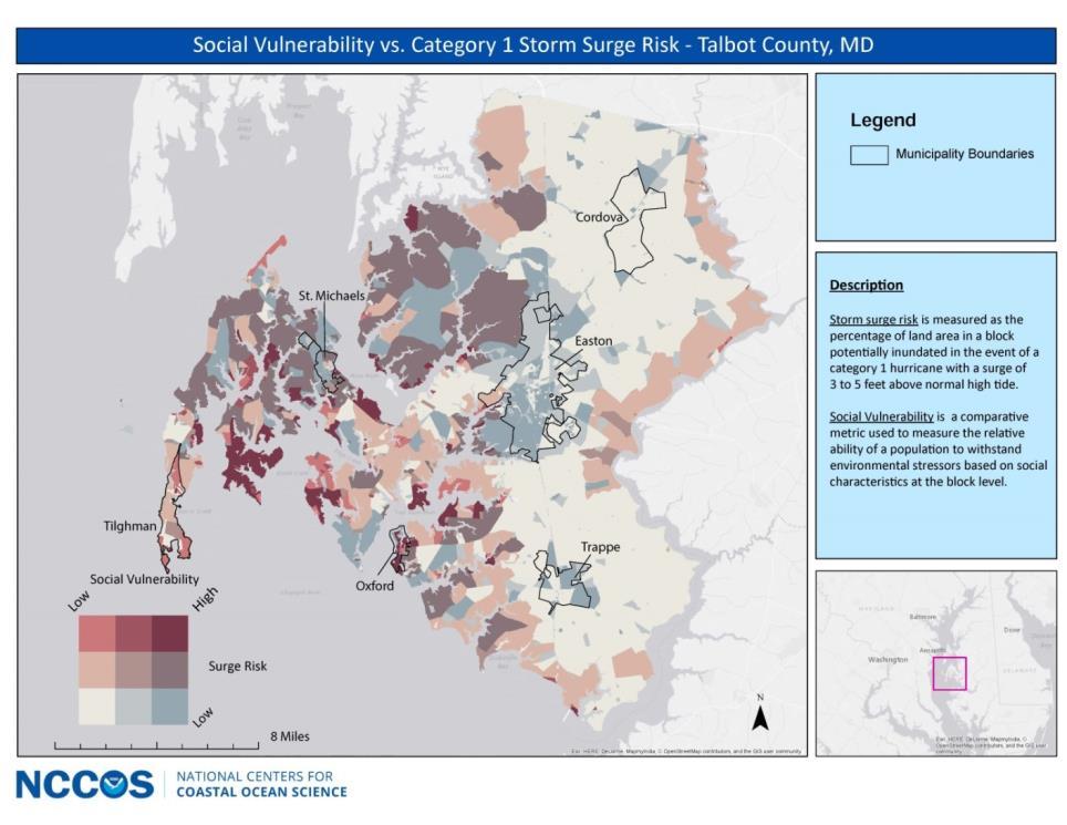
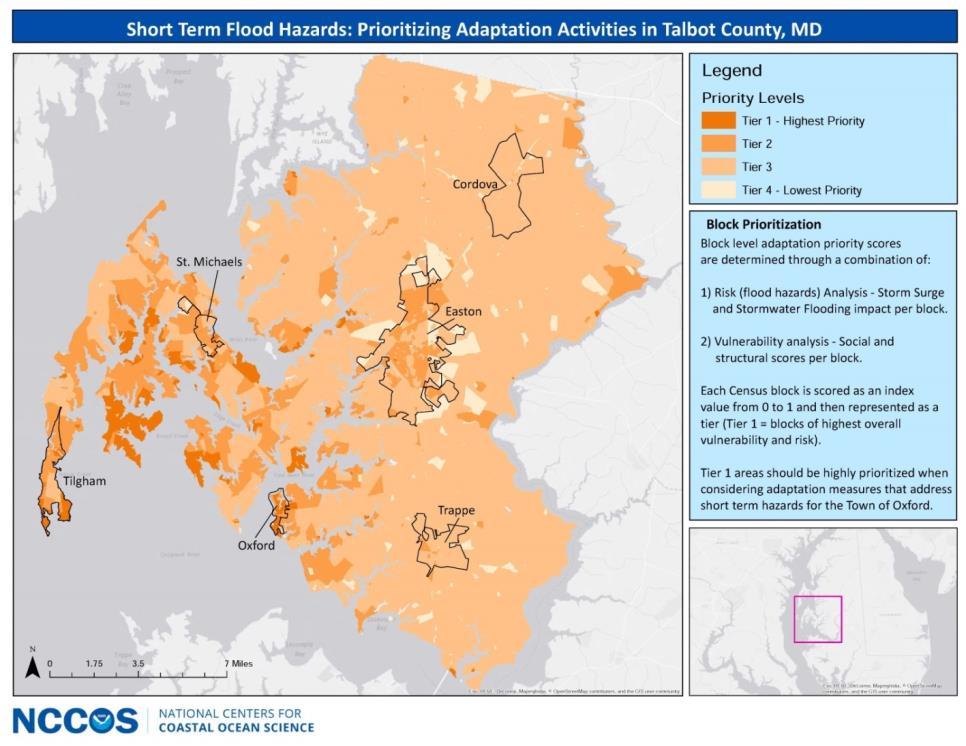
23 Advancing Green Infrastructure Key tools, training, and resources through the Digital Coast: Coastal Flood Exposure Mapper A Guide to Assessing Green Infrastructure Costs and Benefits for Flood Reduction Living shoreline guidance Introducing Green Infrastructure for Coastal Resilience training Climate Adaptation for Coastal Communities training NATIONAL OCEAN SERVICE oceanservice.noaa.gov
 Voluntary state and federal partnership NERRS Science Collaborative 34 federally approved programs Living shorelines and erosion (FL) Performance of sustainable shorelines")
24 Enhanced emphasis on NNBF in new projects Tools and models for scenario evaluations (Gulf and CA) Coastal Zone Management Act Valuing ecosystem services (OR) Thin layer disposal of dredge spoil at Camp Lejeune (NC) Voluntary state and federal partnership NERRS Science Collaborative 34 federally approved programs Living shorelines and erosion (FL) Performance of sustainable shorelines Comprehensive approach to critical coastal issues
 Living shorelines and erosion (FL) Supports protection of natural")
25 Enhanced emphasis on NNBF in new projects The Texas General Land Office Tools and models for scenario evaluations (Gulf and CA) Valuing ecosystem services (OR) Reviews federal actions in the coastal zone to ensure NERRS consistency Science Collaborative with the program Thin layer disposal of dredge spoil at Camp Lejeune (NC) Living shorelines and erosion (FL) Supports protection of natural habitats and wildlife Performance of sustainable shorelines Awards approximately $2.2 million annually in grants Example: South Padre Island and Goose Island Marsh Restoration
26 Enhanced emphasis Strategies on NNBF in new projects Tools and models for scenario evaluations (Gulf and CA) Increase use of living shorelines Valuing ecosystem services (OR) Thin layer disposal of dredge spoil at Camp Lejeune (NC) Update and improve topographic and bathymetry models NERRS Science Collaborative Develop regional sediment management plans to identify potential Living shorelines restoration and erosion sites (FL) in the vicinity of navigation projects. Performance of sustainable shorelines Develop sediment supply studies and source identification mapping
 Restoration Thin layer for disposal multiple of dredge types of spoil at Camp Lejeune (NC) habitat NERRS Science Collaborative Led by Texas General Land Office, supported")
27 Enhanced emphasis on NNBF in new projects Community, socio-economic, ecological, Tools and and models infrastructure for scenario evaluations (Gulf and CA) protection from coastal hazards Valuing ecosystem services (OR) Restoration Thin layer for disposal multiple of dredge types of spoil at Camp Lejeune (NC) habitat NERRS Science Collaborative Led by Texas General Land Office, supported Living shorelines by coastal and zone erosion (FL) management Performance funding of sustainable shorelines NOAA on the technical advisory committee
28 Enhanced emphasis on NNBF in new projects Promoting resilience within human and natural coastal systems Tools and models for scenario evaluations (Gulf and CA) Modeled after Mid-Atlantic Hurricane Sandy study Valuing ecosystem services (OR) Study Thin framework layer disposal of dredge spoil at Camp Lejeune (NC) Identify problems and opportunities NERRS Assess Science vulnerability Collaborative and determine response Complete a programmatic coastal resiliency plan Living shorelines and erosion (FL) Themes Performance of interest: of sustainable green and shorelines port infrastructure; sand management and littoral drift study; coastal habitat conservation; erosion; flooding; bluff recession; dune restoration; beach nourishment; shoreline protection; and nearshore water quality
29 NOAA Coastal Resilience Grants Program hot off the presses - grants, new projects. Nature-based solutions Geospatial data and tool development Economic research

 NERRS Science Collaborative Living shorelines and")
30 Enhanced emphasis on NNBF in new projects 29 sites in national system Over 1.3 million acres protected Research, education, stewardship Living laboratories Locally relevant, nationally significant research Tools and models for scenario evaluations (Gulf and CA) Valuing ecosystem services (OR) Thin layer disposal of dredge spoil at Camp Lejeune (NC) NERRS Science Collaborative Living shorelines and erosion (FL) Performance of sustainable shorelines
31 Enhanced emphasis on NNBF in new projects Tools and models for scenario evaluations (Gulf and CA) University of Texas, Marine Science Institute Valuing ecosystem services (OR) Protects 186,189 acres Thin layer disposal of dredge spoil at Camp Lejeune (NC) NERRS Science Collaborative Located 30 miles northeast of Corpus Christi Living shorelines and erosion (FL) Performance of sustainable shorelines Habitat includes tidal flats, seagrass beds, mangroves, and oyster reefs. Serves as the winter home to the critically endangered Whooping Crane.
 NERRS Science Collaborative Living shorelines and erosion (FL) Focus: environment, economy, and community Performance of sustainable shorelines Example Project Live")
32 Enhanced emphasis on NNBF in new projects Tools and models for scenario evaluations (Gulf and CA) Aransas County Coastal Resiliency Initiative Valuing ecosystem services (OR) Thin layer disposal of dredge spoil at Camp Lejeune (NC) NERRS Science Collaborative Living shorelines and erosion (FL) Focus: environment, economy, and community Performance of sustainable shorelines Example Project Live Oak Peninsula Promoting coastal resiliency by protecting important infrastructure
 NERRS Science Collaborative Living shorelines and erosion (FL) Focus: Shoreline erosion control, salt marsh habitat protection, Performance of sustainable shorelines and")
33 Enhanced emphasis on NNBF in new projects Swift Tract Living Shoreline Project Tools and models for scenario evaluations (Gulf and CA) Valuing ecosystem services (OR) Thin layer disposal of dredge spoil at Camp Lejeune (NC) NERRS Science Collaborative Living shorelines and erosion (FL) Focus: Shoreline erosion control, salt marsh habitat protection, Performance of sustainable shorelines and restoration of ecosystem diversity and benthic productivity 1.6 miles of breakwaters constructed with oyster shell in Mobile Bay
 Thin layer disposal of dredge spoil at Camp Lejeune (NC) Living shorelines and erosion (FL) Performance of")
34 Enhanced emphasis on NNBF in new projects Coral Reef Conservation Act Valuing ecosystem services (OR) Preserve, sustain, and restore NERRS Science Collaborative National and international leadership U.S. Coral Reef Task Force Tools and models for scenario evaluations (Gulf and CA) Thin layer disposal of dredge spoil at Camp Lejeune (NC) Living shorelines and erosion (FL) Performance of sustainable shorelines
35


 Performance of")
36 Enhanced emphasis on NNBF in new projects Benthic Marine boundaries Imagery Coastal land cover Lidar Elevation Bathymetry Socioeconomic data Tools and models for scenario evaluations (Gulf and CA) Valuing ecosystem services (OR) Thin layer disposal of dredge spoil at Camp Lejeune (NC) NERRS Science Collaborative Living shorelines and erosion (FL) Performance of sustainable shorelines
37 Enhanced emphasis on NNBF in new projects Twenty-five Tools and percent, models for or scenario 74,466 evaluations people, (Gulf live in and the CA) floodplain in Galveston County, Texas. Valuing ecosystem services (OR) FLOOD RISK POPULATIONS Thin layer disposal of dredge COASTAL spoil HAZARDS at Camp Lejeune (NC) 84 Billion dollar disasters from NERRS Science Collaborative Living shorelines and erosion CHANGING (FL) LANDS Texas experienced Performance 5,677 of sustainable square shorelines miles of change between , with the largest change being a 1,327-square-mile loss of forest. OCEAN ECONOMICS Offshore mineral extraction is the largest employer among Texas's ocean-dependent economic sectors.

38 DELTE THIS SLIDE

 NATIONAL OCEAN SERVICE oceanservice.")
39 Coastal Land Cover and Land Change Data 17% increase in developed area = 580 square miles = football field every 26 minutes 11% decrease in tree cover = 1,325 square miles = football field every 12 minutes Houston development changes (1996 to 2011) NATIONAL OCEAN SERVICE oceanservice.noaa.gov
 Thin layer disposal of dredge spoil at Camp Lejeune (NC) Living shorelines and erosion (FL) Performance of sustainable shorelines Top Products")
40 Types Enhanced emphasis on NNBF in new projects Analysis tools Data Valuing visualization ecosystem services and (OR) handler tools Simulation tools NERRS Informational Science Collaborative tools Tools and models for scenario evaluations (Gulf and CA) Thin layer disposal of dredge spoil at Camp Lejeune (NC) Living shorelines and erosion (FL) Performance of sustainable shorelines Top Products Sea Level Rise Viewer Lake Level Viewer Historical Hurricane Tracks Coastal Flood Exposure Mapper Coastal County Snapshots
41 NOS capabilities to advance resilience and natural infrastructure Coastal management Coastal intelligence Coastal science Strengthen application and facilitate implementation of natural infrastructure NATIONAL OCEAN SERVICE oceanservice.noaa.gov 41