Mississippi River Hydrodynamic and Delta Management Study
|
|
|
- Kathleen Johns
- 5 years ago
- Views:
Transcription


1 Mississippi River Hydrodynamic and Delta Management Study NGO Briefing 25Sep2014 Cherie Price Regional Planning and Environmental Division South US Army Corps of Engineers
2 Study Reinitiation Rescoping Received an exemption from 3x3x3 Study reinitiated on January 21,

3 Study Status Developed and Screened the Initial Array of Measures and Alternatives to a Focused Array Developed technical scopes of work AdH Delft3D EwE CASM Alternative Milestone is October 27th Concurrence from VT on Focused Array and Path Forward to TSP 3


4 Study Reinitiation 4
5 Identifying Measures and Alternatives Local Sponsor requested inclusion of Louisiana 2012 State Master Plan (SMP) Final Array of alternatives that use the MR as a sediment resource. PDT also brainstormed to consider new ideas. The measures and initial array of alternatives included the same operating plans/locations/assumptions as was evaluated in the Master Plan. The PDT will evaluate these assumptions further using refined models to select a TSP.


6 Project Area 6
7 Initial Screening Criteria Objective Criteria Acres created Habitat Diversity (salinity shifts and HSIs) Constraint Criteria River Impacts sediment/dredging volume changes, stage decreases or increases, total water volume removed. Basin Flooding Impacts stage differences
8 Methods and Models 2012 Louisiana State Master Plan Model Output Acres, HSIs, Salinities, Basin Stage Hydrodynamic Study 1D River Models Stage, Sediment/Dredging Volume Changes Analytic Methods and New AdH (screening level) Acres, Salinities, Stage Existing LCA Models White Ditch, Myrtle Grove Salinities, Stage

9 BUILDING STRONG

10 Lower Barataria: PB039 Magnolia Alternative


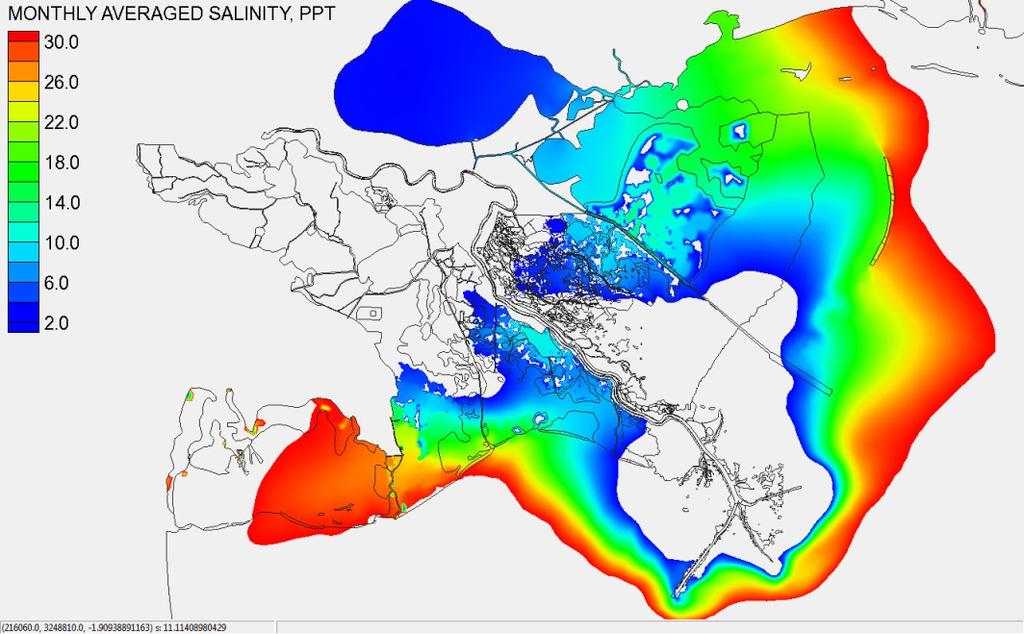

11 Month-Averaged Salinity: June Run3: Upper Breton Sound Without Project 11

12 Water Surface Elevation Impacts Run6: Lower Barataria and Lower Breton 12
13 Screened Measures/Plans Diversions Upper Breton Sound Diversion screened (moved to future implementation) based on basin flooding and habitat diversity impacts. Central Wetlands screened based on basin flooding, and low acres. Marsh Creation Barataria Bay Rim and Breton Rim screened because of SLR impacts, and sustainability. Hopedale screened because of low acres, least benefit to system and land locked. Lake Borgne, NO East, and Golden Triangle were screened because of proximity to diversion influence areas.
14 Pertinent Screening Information New Marsh creation sites were added in the same footprint as diversion land building. The team will make direct comparisons of diversions to marsh creation keeping as many variables constant as possible (including the sediment resource/bar in the river). Outfall management add ons will be included in sensitivity analysis of the focused array of alternatives to optimize diversion performance. Diversion induced shoaled material will be utilized for outfall management/marsh creation.

15 BUILDING STRONG 15
16 Screening of Focused Array to a TSP Developing the Science 2 multidimensional numerical models addressing local and system wide hydrodynamics, salinity, sediment dynamics, morphological characteristics, nutrient dynamics, and ecosystem dynamics. AdH/SEDLIB 2D depth-averaged mode with quasi 3D sediment behavior. Primary Productivity Model included in SEDLIB Simplified Box Model for water quality constituents Delft 3D Data Collection Marsh Elevation, Bathymetry, Meteorological, Stage, Temperature, Velocities, Chlorophyll a, DO, Salinity, Turbidity, Above and Below Ground Biomass/Soil Organic Matter/Mineral Sediment Content/Soil Strength Developing a Wetland Soil Model Component Nutrient Dynamic and Morphodynamic Module 16
17 Screening of Focused Array to a TSP Developing the Science 2 Ecological (primarily fisheries) Models Ecopath with Ecosim (EwE) Open source ecosystem modeling software, originally developed by Polovina (1984) to model trophic interactions and to estimate mean annual biomass of the French Frigate Shoal coral reef ecosystem. These models are Mass-balanced (Ecopath), time-dynamic (Ecosim) and spatially explicit (Ecospace) Comprehensive Aquatic System Model (CASM) Determine effects of large scale river diversions and other project features on economically and ecologically important fish and shellfish species in Pontchartrain and Barataria Basins. 17
18 Delta Management Milestones FCSA Signed 24 Aug 2011 National Planning Charette Oct 2012 Waiver Approved 29 Jul 2013 Develop Initial Array of Alternatives 24 Apr14 Screen Initial Array of Alternatives 15 Aug 2014 Alternatives Milestone IPR #1 15 Oct 2014 Tentatively Selected Plan Milestone Meeting #2 19 Aug 2015 Agency Decision Milestone Meeting #3 25 Mar 2016 Final Report Submittal 04 Jul 2016 Civil Works Review Board #4 16 Sep 2016 Chief s Report Milestone #5 16 Dec


19 Questions? 19