SSA LOCATION MAP
|
|
|
- Rebecca Daniel
- 5 years ago
- Views:
Transcription
1 SSA
2 ROCKAWA Y CR E EK RD MEA D OWS L N NOKOMIS RD PIN E BA RRE N CH UR CH R D W H IGHW A Y 4 R OCKA WA Y C RE E K R D PIN E FOREST RD F IC K LIN R D H OL L OW RD S A ND Y YOUNG R D PE LT R D S EA L ES R D DE E R LA K E R D SAND Y HOLLOW RD This map is provided for information purposes only. The data is not guaranteed accurate or suitable for any use other than that for which it was gathered. AL LE N R D Andrew Holmer Planning and Zoning Dept. KA N S AS RD H IG H WA Y 97 SSA LOCATION MAP 0 2,000 4,000 6,000 Ft GOBBLER RD PRINCIPAL ARTERIAL GREEN VILL A GE R D MINOR ARTERIAL COLLECTOR LOCAL ROAD RAILROAD
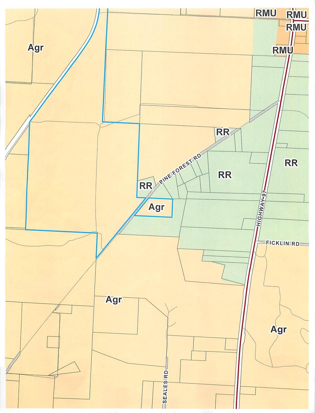
3 Agr Agr Agr RR PIN E F OR EST RD RR Agr RR RR Agr Agr This map is provided for information purposes only. The data is not guaranteed accurate or suitable for any use other than that for which it was gathered. Andrew Holmer Planning and Zoning Dept. SSA ' RADIUS ZONING ,200 Ft PARCELS PRINCIPAL ARTERIAL MINOR ARTERIAL COLLECTOR LOCAL ROAD RAILROAD
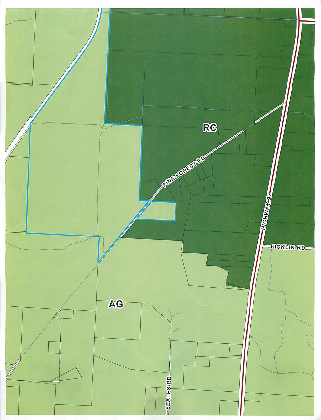
4 RC AG +/ acres RC PIN E F OR EST RD AG +/- 2.5 acres AG RC AG AG AG This map is provided for information purposes only. The data is not guaranteed accurate or suitable for any use other than that for which it was gathered. Andrew Holmer Planning and Zoning Dept. SSA FUTURE LAND USE ,200 Ft PARCELS PRINCIPAL ARTERIAL MINOR ARTERIAL COLLECTOR LOCAL ROAD RAILROAD
5 RC AG RC PIN E F OR EST RD AG AG RC AG AG AG This map is provided for information purposes only. The data is not guaranteed accurate or suitable for any use other than that for which it was gathered. Andrew Holmer Planning and Zoning Dept. SSA PROPOSED FLU ,200 Ft PARCELS PRINCIPAL ARTERIAL MINOR ARTERIAL COLLECTOR LOCAL ROAD RAILROAD


6 P IN E FOR EST R D This map is provided for information purposes only. The data is not guaranteed accurate or suitable for any use other than that for which it was gathered. Andrew Holmer Planning and Zoning Dept. SSA AERIAL MAP Ft PARCELS PRINCIPAL ARTERIAL MINOR ARTERIAL COLLECTOR LOCAL ROAD RAILROAD


7 Public Hearing Sign


8 Looking East across Pine Forest Rd from subject parcel


9 Looking Northeast from Pine Forest Rd


10 Looking Northwest from Pine Forest Rd


11 Looking Southwest from parcel onto Pine Forest Rd
12 May 24, 2017 To Whom it May Concern, Re: Parcel ID 38-5N / 5700 Pine Forest Road,Walnut Hill, FL My son and Iare row-crop and cattle farmers, and in efforts to expand our production, wealong with our wives, recently bought approximately 255 +/- acres (individual parcels, butall abutting). We purchased this property for the sole reason of it being prime farmland. However, the property came with a single-family residence of which we have no need for. Sothat we are following the rules and regulations of Escambia County, we are formally requesting a Future Land Use Map Amendment, aswell as, a Rezoning. We are requesting this so that we can properly cut out the single-family residence, and have it meet code, sothat any future buyerwill not have any issues regarding the zoning uses and/or building permits for the property. Currently, the parcel that we are asking to be changed is zoned Agriculture with a FLU designation of Agriculture. We would like to request a Future Land Use Map Amendment change to the Rural Community designation so that we do not have to carve out 20 acres ofthe prime farmland that we just purchased for our business. The designation of RuralCommunity would be consistent with our rezoning request of Rural Residential. Thank you for your consideration, Susan k. Ward Burton H. Ward Kathryn Elizabeth H. Ward
13
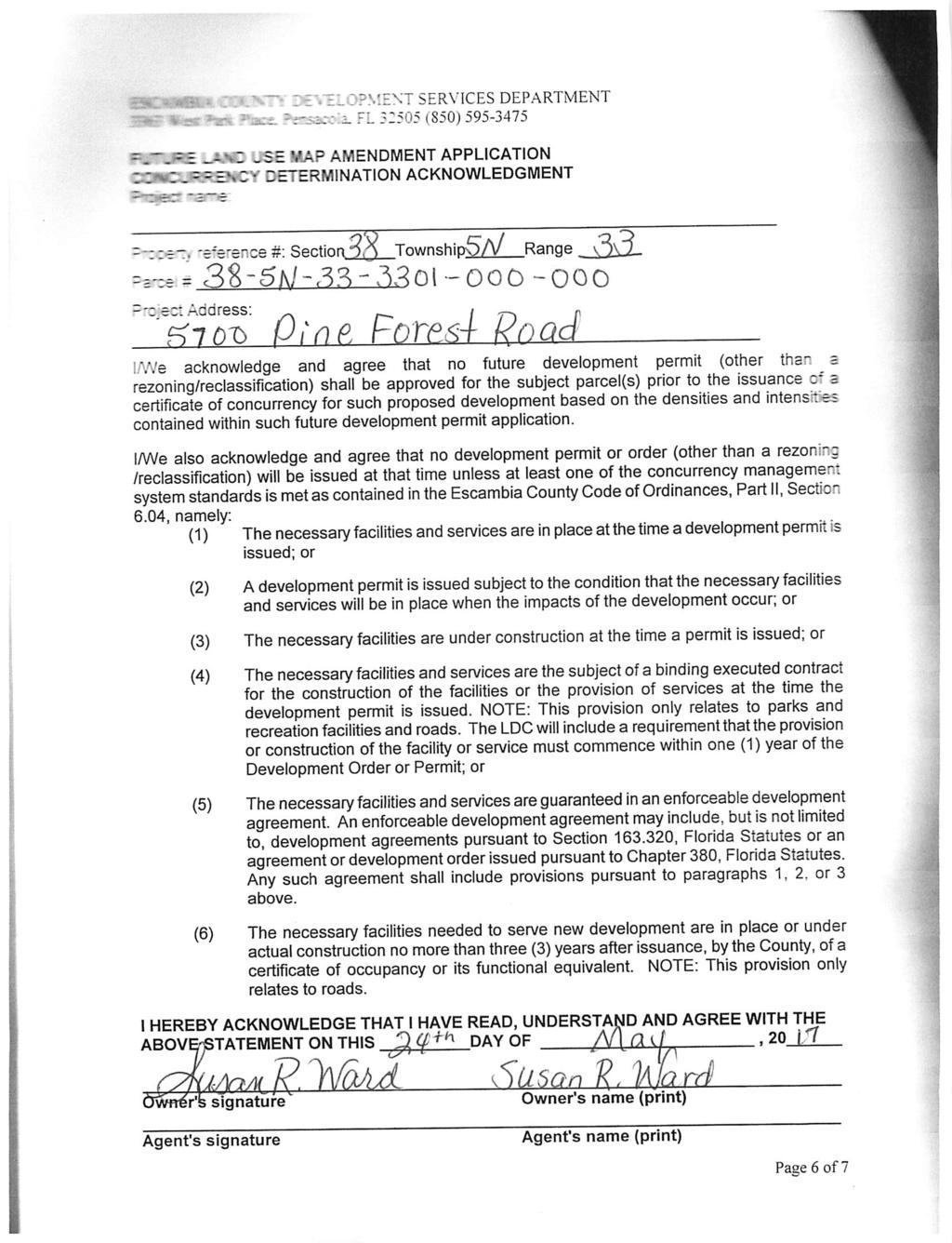
14 ESCAMBIA COUNTY DEVELOPMENT SERVICES DEPARTMENT 3363 West Park Place, Pensacola, FL (850) FUTURE LAND USE MAP AMENDMENT APPLICATION (THIS SECTION FOR OFFICE USE ONLY): TYPE OF REQUEST: SMALL SCALE FLU AMENDMENT LARGE SCALE FLU AMENDMENT Current FLU: Desired FLU: Zoning: Taken by:. Planning Board Public Hearing, date(s): BCC Public Hearing, proposed date(s): Fees Paid Receipt # Date: OWNER'S NAME AND HOME ADDRESS AS SHOWN ON PUBLIC RECORDS OF ESCAMBIA COUNTY, FL Name: f)\x(]py\ flp.clh\ flhrl 1^0+^11 t\ lalm h H Klflr/j Address: 5090 Arthur fro^n Koad city: 1/vlalnut \\\ State: EL Zip Code: 325(A? Telephone: (2$l ) 35^1 A(j>DO ^V\Vvlfld 1 QDQdj 1 CX)frA DESCRIPTION OF PROPERTY: Street address: Subdivision: Property reference number: Section Size of Property (acres) Parcel Lot Township Block.Range_ FLU Page 3 of 7

15
16

17
18

19
20

21
22
23
24
25
26
27
28
29
30
31
32
33
34
 Comments SSA-2017-03 and Z-2017-07 TTO Staff has reviewed the Small Scale Map Amendment")
35 BOARD OF COUNTY COMMISSIONERS ESCAMBIA COUNTY, FLORIDA INTEROFFICE MEMORANDUM TO: FROM: Andrew Holmer, Development Services Manager Development Services Department David Forte, Division Manager Transportation & Traffic Operations Division DATE: June 7, 2017 RE: Transportation & Traffic Operations (TTO) Comments SSA and Z TTO Staff has reviewed the Small Scale Map Amendment (SSA) and Rezoning Case (Z) , 5700 SR297 (Pine Forest Road), agenda item for the upcoming Planning Board meeting scheduled for July 11, Please see the below comments. Currently, there are no Roadway Improvement Projects programmed in the County s Capital Improvement Program or the State of Florida s Florida Department of Transportation (FDOT) 5-Year Work Program along Pine Forest Road within the vicinity of the subject parcel. Per the Florida-Alabama Transportation Planning Organization (TPO) Congestion Management Process Plan, Pine Forest Road is currently functioning within its allowable capacity for traffic volumes between the segment of SR10A (Mobile Hwy) and I-10. The maximum level-of-service (LOS) for the roadway segment is LOS D (39,800 trips/day), and currently the roadway segment is functioning at a LOS C (26,000 trips/day) and is not expected to exceed 29,000 trips/day by Year 2024, which is still within the allowable LOS roadway standard. The TPO 2040 Long Range Transportation Plan (LRTP) does include a capacity project along Mobile Highway from Nine Mile Road to Godwin Lane, which lies just west of the subject parcel, to widen to 4 lanes. The 2040 LRTP proposes Federal/State dollars to fund the engineering design phase ($10.4M) for this section of Mobile Highway within the timeframe. However, no right-of-way ($17.3M) or construction ($39.7M) funds are proposed in the LRTP at this time. Due to the information provided above, TTO Staff does not have any concerns with the proposed SSA and/or the rezoning request; however, TTO s review hold no bearing on future TTO comments during the Development Review process WEST PARK PLACE PENSACOLA, FLORIDA (FAX)
36 cc: Horace Jones, Development Services Department Director Joy Blackmon, P.E., Public Works Department Director Colby Brown, P.E., Public Works Department Deputy Director
37 Comprehensive Plan Amendment Staff Analysis General Data Project Name: SSA Location: 5700 Pine Forest Road Parcel #s: 38-5N (Parent Parcel) Acreage: (+/-) acres Request: From Agricultural (AG) to Rural Community (RC) Applicant: Brett and Susan Ward, Owners Meeting Dates: Planning Board July 10, 2017 BCC August 3, 2017 Summary of Proposed Amendment: The proposed amendment is for a parcel totaling 2.50 (+/-) acre, accessed from Pine Forest Road. The proposed small scale amendment meets the following conditions in order to be classified as a small scale comprehensive plan amendment: a) The parcel is 2.50 (+/-) acres which is under the 10 acres or fewer as stated in (1)(a). b) This amendment is the third small scale amendment for this calendar year; therefore, it will not exceed the maximum of 120 acres in a calendar year as stated in F.S (1)(b). c) The proposed amendment is not located within a designated area of critical state concern. The applicants have requested a Future Land Use (FLU) map amendment to change the FLU category of a parcel totaling 2.50(+/-) acre, from Agricultural (AG) to Rural Community (RC). Based on the request, the FLU change along with a concurrently requested rezoning from Agriculture (Agr), to Rural Residential (RR), would allow for the separation of an existing residential unit from the primary farmland operations. Sec Comprehensive Plan future land use and text amendments. (3) Compliance review. The Planning Board shall consider a requested Comprehensive Plan map amendment during the noticed meeting of the board and determine any subsequent actions. At the conclusion of the hearing, the Planning Board shall adopt a recommendation to the BCC for adoption, adoption with modification, or rejection of the amendment. a. General amendment conditions. All amendments to the Comprehensive Plan shall demonstrate the following general conditions, allowing that where an amendment is imposed by a state or federal requirement it need only demonstrate the conditions to the greatest extent practicable under that requirement: 1. Need and benefit. There is an identified land use need particular to the scope and function of the Comprehensive Plan for which an amendment is clearly
38 SSA warranted. 2. Professional practices. The proposed amendment applies contemporary planning principles, engineering standards, and other professional practices to provide an effective and efficient remedy for the identified land use problem or need. Staff Analysis: To provide protection to prime farmland and prevent the unnecessary and irreversible conversion of large tracks of farmland into non-agricultural uses, the RC FLU recognize existing residential development that serves the rural and agricultural areas of Escambia County. Farming is an important aspect of our community; planning principles used to encourage the protection of prime farmland in the County, as provided for specific allowances in the Comprehensive Plan and in the Land Development Code. In the Land Development Code (LDC), Sec Rural Residential district (RR) describe the clustering of smaller residential lots where needed to protect prime farmland from non-agricultural use. b. FLUM amendment conditions. In addition to the general amendment conditions, a future land use map amendment shall be based upon analyses by Florida Statute. Land Use Impacts: Residential Impact Comprehensive Plan Policy (CPP) 1.3.1, the current Agriculture (AG) FLU is intended for routine agricultural and silvicultural related activities and very low density residential uses. Also, allows for commercial activity limited to those endeavors ancillary to agricultural and silvicultural pursuits or in support of agricultural activities such as seed, feed and food outlets, farm equipment and repair and veterinary services. The range of allowable uses includes agriculture, silviculture, residential, recreational, public and civic, limited ancillary or supportive, commercial. The residential maximum density is 1 du/20 acres. The proposed amendment to Rural Community (RC) is intended to recognize existing residential development and neighborhood serving nonresidential activity through a compact development pattern that serves the rural and agricultural areas of Escambia County. The range of allowable uses includes agriculture, silviculture, residential, recreational facilities, public and civic, compact traditional neighborhood supportive commercial. The residential maximum density is 2 du/acre Staff Analysis: The applicant is concurrently requesting a rezoning from Agr to RR. If the rezoning is approved, then the proposed FLU change to RC would be compatible with the existing surrounding area densities and intensities. The current development trend in this area of the County identifies the existence of rural residential development along existing roadways, in support of the primary agricultural development. The parcel already has a single-family residence and accessory structures on-site. Infrastructure Availability: FLU New Development and Redevelopment in Built Areas To promote the efficient use of existing public roads, utilities and service infrastructure, the County will encourage redevelopment in underutilized properties to maximize development densities and intensities located in the Mixed Use-Suburban, Mixed Use-Urban, Commercial and Industrial Future Land Use districts categories (except for residential development). Page 2 of 5
39 SSA GOAL CMS 1 Concurrency Management System Escambia County will adopt a Concurrency Management System to ensure that facilities and services needed to support development are available concurrent with the impacts of such development. The Concurrency Management System will be determined by the provisions of the LDC. Potable Water The applicant has the responsibility to contact the local water provider to ensure the provider can support the proposed use. The adopted level of service (LOS) standards for potable water is established in Comprehensive Plan Policy INF Sanitary Sewer The adopted level of service standards for sanitary sewer established in Comprehensive Plan Policy INF are an average of 210 gallons per residential connection per day and a peak of 350 gallons per residential connection per day. The policy also states that the LOS requirements for non-residential uses shall be based upon an equivalent residential connection calculated by the provider and on the size of the non-residential water meter. Solid Waste Disposal As established in Comprehensive Plan policy INF 2.1.4, the adopted LOS standard for solid waste disposal in the county is six pounds per capita per day. Stormwater Management INF County System Improvements. Escambia County will continue its practice of enhancing localized and regional drainage systems to increase the LOS associated with development prior to current stormwater management requirements. INF Stormwater Management Enforcement. Escambia County will continue enforcement of its stormwater management ordinance, consistent with the Capital Improvements Element and in cooperation with the municipalities and regulatory agencies, pursuant to the detailed guidance provided by Escambia County's stormwater management plan. INF Concurrency Management. Escambia County will ensure the provision of stormwater management facilities concurrent with the demand for such facilities as created by development or redevelopment through implementation of the Concurrency Management System. INF Level of Service (LOS) Standards. Stormwater management LOS will be monitored through the provisions in the LDC design standards. INF Natural Drainage Features. Existing functioning drainage features will be utilized whenever sufficient capacity is available within such features. Utilization of natural drainage features will be required when such use does not impact sensitive natural resources. The LDC will include land use regulations that require site-specific development plans to protect natural Page 3 of 5
40 SSA drainage features and incorporate such features into the site planning and development process. INF Untreated Stormwater. Channeling untreated run-off directly into receiving waters will be prohibited. Thus, no new "direct" discharge of untreated stormwater will be permitted. Note: For the purposes of this plan, adequate vegetative filtration of sheet flow from pervious surfaces may be considered treatment. Transportation System MOB On-site Facilities. All new private development will be required to provide safe and convenient on-site traffic flow as indicated in the LDC. MOB Access Management. Escambia County will promote access management by limiting the number of conflict points that a motorist experiences during travel, separating conflict points as much as possible when they cannot be eliminated, and controlling the turning movements to facilitate traffic flow on affected roadways. MOB Consistency. All plans and proposals for development and redevelopment as well as all land use decisions will be reviewed for consistency with the FLUM. Staff Analysis: The parcel has a single-family residence on-site promoting the efficient use of existing public roads and infrastructure. The applicant is not proposing any other development. Impact on Wellheads, Historically Significant Sites and the Natural Environment: Wellheads: CON Wellhead Protection. Escambia County shall provide comprehensive wellhead protection from potential adverse impacts to current and future public water supplies. The provisions shall establish specific wellhead protection areas and address incompatible land uses, including prohibited activities and materials, within those areas. Historically Significant Sites: FLU State Assistance. Escambia County shall utilize all available resources of the Florida Department of State, Division of Historical Resources in the identification of archeological and/or historic sites or structures within the County. The County will utilize guidance, direction and technical assistance received from this agency to develop provisions and regulations for the preservation and protection of such sites and structures. In addition, the County will utilize assistance from this agency together with other sources, such as the University of West Florida, in identifying newly discovered historic or archaeological resources. The identification will include an analysis to determine the significance of the resource. Wetlands: CON Wetland and Habitat Indicators. Escambia County has adopted and will use the National Wetlands Inventory Map, the Escambia County Soils Survey, and the Florida Fish and Wildlife Conservation Commission s (FFWCC) LANDSAT imagery as indicators of the potential presence of wetlands or listed wildlife habitat in the review of applications for development approval. The Escambia County Hydric Soils Map is attached to this ordinance as Exhibit N. Page 4 of 5
41 SSA Staff Analysis: Based on public records, the existing residence was built in 1975 and it s the primary residential use of the new 2.5 +/- acre parcel created. The parcel appears to be located outside of the well-head travel time contours. The applicant did not provide a significant historical site review; however, it s worth noting that the parcel in question contains existing residential and accessory structures. The applicant is not proposing any other development onsite; we recommend that any new proposed development within the parcel would have to be reviewed for cultural resources. From a review of the available National Wetland Inventory maps, there appears to be no environmentally sensitive lands on the subject parcel. Any future development shall be analyzed for environmental compliance with regulations prior to the issuance of any site plan approval. Comprehensive Plan Consistency and Relevant Policies: Rural Community Future Land Use Category: FLU FLUM Rural Community (RC) General Description: Intended to recognize existing residential development and neighborhood serving nonresidential activity through a compact development pattern that serves the rural and agricultural areas of Escambia County. Staff Analysis: The proposed FLU change to RC is compatible with the existing surrounding uses and will not have a negative impact upon existing public roads, utilities and service infrastructures. The development trend is rural residential development along the existing roadways. The existing residence already makes use of available infrastructure and is compatible with the surrounding uses and intensities. Summary: If the rezoning application to RR is approved, then the request to assign a FLU of RC would be compatible with the current requirements of the Comprehensive Plan and of the Land Development Code. To protect the agricultural and rural character of that area in Escambia County, both the LDC and the Comprehensive Plan have allowances to accommodate single-family residences as accessory and supportive uses to the farming operations. Page 5 of 5