Sustainable Groundwater Management Act (SGMA) Program Guide
|
|
|
- Kerry Johnson
- 5 years ago
- Views:
Transcription
 Program")

1 Sustainable Groundwater Management Act (SGMA) Program Guide February 2, 2017 In association with: For the Delta Mendota Subbasin
2 SGMA Overview
3 DWR publishes a report on water available for groundwater replenishment 12/31/2016 DWR publishes best management practices for sustainable management of groundwater Timeline DWR publishes the interim update to Bulletin 118 (California Groundwater), documenting basin boundary modifications, basin prioritization, and critical overdraft. 1/1/2017 SWRCB begins collecting annual reports from persons extracting more than 2 AFY from areas outside GSA jurisdiction. 12/15/2017 SWRCB may hold hearing to designate a basin as probationary if a GSA or alternative is not established 6/30/2017 SWRCB adopts a fee schedule for State back stop related costs 7/1/2017 SWRCB begins development of interim plans if local agency has not remedied deficiency resulting in probationary basin status. Probationary basins may petition for un designation. DWR to consult. 1/1/2018 Board may hold hearings to designate criticallyoverdrafted basins as probationary if DWR determines their GSP is inadequate or will not achieve sustainability. 1/31/2020 SWRCB begins development of interim plans for critically overdrafted basins designated as probationary. 1/1/2021 SWRCB may hold hearing to designate high and medium priority basins as probationary if DWR determines that the GSP is inadequate or will not achieve sustainability 1/31/2022 SWRCB may designate a groundwater basin as probationary if DWR determines the GSP is inadequate or not being implemented properly and SWRCB determines the basin is in a condition where groundwater extractions result in significant depletion of interconnected water surfaces. 1/31/ Today
4 Groundwater Sustainability Agencies (GSAs) GSAs must be formed and approved by June 30,2017 GSAs must contain local public agency that has water supply, water management, or land use responsibilities For basins where no agency forms a GSA, the County assumes the GSA role GSAs required to develop and implement GSP to achieve sustainability goal by 2040
5 Groundwater Sustainability Plans (GSPs) Must be adopted by GSAs and submitted to DWR by January 31, 2020 Groundwater sustainability to be achieved within 20 years GSP to have 50 year planning horizon DWR approval of GSP required to avoid State intervention Annual reporting required to demonstrate progress towards sustainability goal GSPs must be updated every 5 years Groundwater monitoring is required
6 Planning and Resources
7 GSP Requirements Technical and Reporting Standards Monitoring Protocols Administrative Information General Information Agency Informationi Description of Plan Area and Map(s) Water Resources Monitoring and Management Program Land Use Elements Additional GSP Contents Notice and Communication Basin Setting Hydrologeologic Conceptual model Recharge Areas with Map Current and Historical Groundwater Conditions Water Budget Information Surface Water Supply Management Areas Sustainable Management Criteria Sustainability Goal Undesirable Results Minimum Thresholds Measurable Objectives Monitoring Networks Monitoring Network Representative Monitoring Assessment and Improvement of Monitoring Network Projects and Management Actions Projects and Management Actions
8 Optional Components Description of actions related to: Control of saline water intrusion Wellhead protection Migration of contaminated groundwater Well construction, abandonment and destruction program Replenishment of groundwater extractions Conjunctive use and underground storage Policies, addressing groundwater contamination cleanup, recharge, diversions to storage, conservation, water recycling, conveyance, and extraction projects Impacts on groundwater dependent ecosystems. Descriptions of: State and federal regulatory agencies Efficient water management practices Land use plans and efforts to coordinate with land use planning agencies
9 Data
10 Required Data HYDROGEOLOGIC CONCEPTUAL MODEL CROPPING AND CROP WATER USE GROUNDWATER RECHARGE OTHER PARAMETERS Management Area Boundaries Cropping Data/Maps Groundwater inflow parameters (gradient and transmissivity) Groundwater storage change parameters (groundwater levels and specific yield) Hydrostratigraphy Irrigation Methods Deep percolation of crop irrigation Soils Geology Irrigation Efficiencies Deep percolation of precipitation Soil infiltration rates Well Construction Characteristics Crop Evapotranspiration Deep percolation of M&I water use Subsidence Depth of usable water Effective Precipitation Channel and pipeline leakage Population / Anticipated growth Configuration of surface water features M&I Landscape Evapotranspiration Reservoir and lake seepage Groundwater levels Water resources facilities NON RECOVERABLE LOSSES Urban stormwater recharge Groundwater surface water interactions WATER SUPPLIES Groundwater outflow parameters Local stream/river seepage Geology (gradient and transmissivity) Surface Water (Irrigation) Channel evaporation Intentional groundwater recharge Well locations Surface Water (M&I) Reservoir/recharge basin evaporation WATER QUALITY Temperature Agency groundwater pumping (Irrigation) Precipitation evaporation and runoff Surface water quality Land use Private groundwater pumping (Irrigation) Operational spills Groundwater quality Agency Groundwater Pumping (M&I) Water exports Private Groundwater Pumping (M&I) Precipitation
11 State and Federal Databases CASGEM (California Statewide Groundwater Elevation Monitoring Program) WDL (Water Data Library) GAMA (Groundwater Ambient Monitoring and Assessment Program) SWAMP (Surface Water Ambient Monitoring Program) ewrims (Electronic Water Rights Information Management System) CEDEN (California Environmental Data Exchange Network) CEIC (California Environmental Information Clearinghouse) CERES (California Environmental Resources Evaluation System) National Water Information System

 Develop protocols with")
12 Data Acquisition Acquire data Normalize and evaluate data Select Data Management System (DMS) Develop protocols with adjacent basins
13 Data Management Success Criteria 1. Seamless Coordination 2. Support for GSP development 3. Centralized project information 4. Transparency 5. Ability to track undesirable results 6. Threshold and impact evaluation 7. Reliable total water budget 8. Sustainability tracking 9. Data sharing Features that Support Success Criteria User and Agency Security/Permissions Data Entry and Validation Visualization and Analysis Management Planning and Actions Water Budget Development and Modeling Management Areas Reporting and Tracking of Critical Parameters Outreach Framework and Ability to Link to other Data Management Systems
14 Data Management Systems Costs and Timeline DMS Options Estimated Cost Range Estimated Timeline Option 1: Off the shelf DMS with no modification $5,000 $30, months Option 2: Off the shelf DMS with modification $10,000 $50, months Option 3: Custom developed DMS $100,000 $250, months Data Conversion (required for all of the above) $10,000 $40, months
15 Tools
16 Tools for GSP Preparation Groundwater flow models Sustainability goals, measurable objectives & minimum thresholds Project development/analysis/prioritization Adaptive management Outreach

17 Hydrogeologic Conceptual Model
18 Integrated Groundwater Surface Water Models Key Feature C2VSim CVHM Code Platform IWFM MODFLOW-FMP Public Domain Code Yes Yes Model Ownership DWR USGS Availability Available from DWR Available on USGS website Documentation Available on DWR website Available on USGS website Integrated Model Yes Yes Geographic Area Central Valley Central Valley Simulation Period (Water Years) Number of Model Layers 6 10 Geologic Formations Represented in the Model Generalized upper unconfined aquifer, confined production zone, deep confined zone Layers not explicitly tied to hydrogeologic units except for Corcoran Clay in the San Joaquin Valley; remainder based on uniform division of aquifer system for modeling purposes Agricultural Demand Estimation Method Stream-Aquifer Interaction Method Integrated methodology using IDC Integrated methodology using IWFM Stream Package Integrated methodology using the Farm Process Integrated methodology using MODFLOW Streamflow Routing Package Elements 32,537 20,533 Average Grid Size 407 acres (0.64 square miles) 640 acres (1 square miles) Time Step Monthly Monthly
19 C2VSim is Recommended Model Cost is the same for modifying both models DWR has selected C2VSim and IWFM platform for SGMA implementation Most adjoining groundwater basin are selecting IWFM C2VSim can provide a consistent set of inter basin flows with the neighboring basins Can use data in CVHM to refine C2VSim model locally

20 Sustainability Goals and Objectives Required by SGMA Sustainability Goals Minimum thresholds Management objectives Monitoring for compliance Interim goals to demonstrate progress


21 Project Identification and Prioritization Define the Problem Develop Method for Evaluation Identify Projects and Management Actions Screen Projects and Management Actions Implement Adaptive Management Create and Evaluate Portfolios Secure Funding Monitoring Implement Projects and Management Actions


22 Decision Support System (DSS) Models Technical Data DSS A DSS can help solve problems that are: Too complex for humans alone Too qualitative for computers alone Have multiple possible solutions Decisions Decision Process

23 Most Common Types of DSSs Systems Thinking for Education and Research


24 Example DSS Network
25 SGMA Outreach Requirements During GSA formation At least one public hearing List of interested parties and how their interests will be considered During GSP development and implementation DWR notification of intent to initiate development of a GSP GSP adoption/amendment public hearing held Public meeting(s) for fee assessment List of persons interested in receiving notices and information Written statement describing how interested parties may participate Throughout SGMA implementation Consider interests of all beneficial uses and users of groundwater Encourage active involvement of diverse social, cultural, and economical elements of the population
26 Possible Outreach Tools Joint fact finding Technical and Public advisory committees Web based tools (databases, GIS mapping platforms, online document libraries) Third party neutral researchers Collaborative models and decision support tools
27 Funding
28 Near Term Funding Options: For GSP Development, Monitoring, Data Collection/Analysis, Outreach Outside Funding Sustainable Groundwater Planning Grant (DWR) SGMA Facilitation Support Services (DWR) IRWM Implementation Grants (DWR) Groundwater Sustainability Grant (SWRCB) Other Funding SGMA Authorities for GSAs (e.g. regulatory fees/assessments) USGS Grants and Cooperative Agreements
29 Long term Funding Options: For GSP Updates, Tool Development and Project/Program Implementation Future Propositions IRWM Implementation Grants (DWR) Water Recycling/Clean Water State Revolving Fund (SWRCB) Drinking Water/Drinking Water State Revolving Fund (SWRCB) Infrastructure State Revolving Fund (I Bank) Groundwater Sustainability Funding (SWRCB) Water Storage Infrastructure Program (CWC) New State Programs SGMA Authorities permit fees, groundwater extraction fees, regulatory action fees, other fees, fees collected as taxes, assessments, charges or tolls Other Non Point Source Grant (SWRCB) Small Community Wastewater Grant (SWRCB) Rural Development Water and Waste Disposal Program (USDA) Environmental Quality Incentives program (NRCS) Community Development Block Grant program (Dept. of Housing and Community Development) Conservation grant programs (BoR WaterSmart) Stormwater Grant Programs (SWRCB) Water Use Efficiency Grant Program (DWR) Other future funding programs
30 GSP Preparation
31 Success Criteria Development Categories for Criterion Water Budget Groundwater Balance Basin Stabilization Monitoring and Reporting Effectiveness Inter Agency Coordination Oversight and Management Tools and Actions Data Accessibility Communication Plan for Uncertainties
32 Proposed GSP Outline Executive Summary 1. Introduction 2. Plan Area 3. Governance 4. Outreach and Communication 5. Basin Setting 6. Sustainable Management Criteria 7. Measurable Objectives 8. Sustainability Implementation 9. Plan Implementation 10. References and Technical Studies Appendices Contact Information for Plan Manager List of Public Meetings and Outreach Activities Interagency Agreements Technical Appendices Groundwater Model Documentation GSP Adoption Activities
33 Schedule for GSP Preparation Initiate Work General Front End Sections Data Collection and Basin Conditions Basin Setting Sustainable Management Criteria Identify Projects and Management Actions Monitoring Plan GSP Compilation Adoption Outreach and communication throughout whole period March 27, 2017 March 27 May 5, 2017 March 27 June 23, 2017 June 26, 2017 March 30, 2018 April 2 May 11, 2018 May 14 June 27, 2018 April 17 May 26, 2017 August 27 November 19, 2018 November 19, 2018 or later

")
34 Estimated Level of Effort (LOE)
35 Alternatives for Cost Allocation Allocation Basis No. Discussion Participants 1 Gross Acreage 5 Simple division of cost by acreage in each GSA. 2 Equal Shares by GSA 5 Each GSA pays an equal share. May not represent value received by GSA. 3 50% by GSA, 50% by Acreage 5 50% cost split based on acreage and number of GSAs. 4 50% by Acreage, 50% by Seat at Table 13 50% of costs paid based on acreage served, with remaining 50% paid based on having a decision making role in the GSP development. 5 50% by Acreage per GSAs with > 10% of Acreage, 10% by Areas with < 10% of acreage 3 Allocates 10% of the cost to each of the GSAs with less than 10% of the acreage, with the remaining cost allocated to the remaining GSAs based on acreage. 6 Total Pumping within each GSA TBD Would allocate cost strictly on average annual groundwater pumping. 7 Total Average Annual Water Use by GSA 8 50% by Total Annual Pumping, 50% by Acreage 9 50% by Total Annual Water Use, 50% by Acreage TBD TBD TBD Would allocate cost strictly on total average annual water use. Would allocate cost with 50% of cost based on average annual groundwater pumping and 50% based on acreage served. Would allocate cost with 50% by total annual water use and 50% by acreage served. 10 Independent Formula Development TBD A new formula for cost allocation would be independently developed specifically for GSP preparation
36 Questions?
37 Statutory Requirements Empowers local agencies to manage groundwater basins in a sustainable manner over a long term period Requires Groundwater Sustainability Agencies (GSAs) formation and development of Groundwater Sustainability Plans (GSPs Limited to California s alluvial groundwater basins that have been deemed to have a high or medium priority. 20 year implementation horizon 50 year planning horizon DWR evaluation and assessment of GSPs and their implementation required Non compliance allows for state intervention GSP preparation exempt from California Environmental Quality Act [CEQA] SGMA does not determine or alter surface water rights or groundwater rights under common law or any provision of law that determines or grants surface water rights.
38 Roles and Responsibilities Local Agencies Responsible for the formation of GSAs and the subsequent development and implementation of GSPs. Local agencies are expected to collaborate and coordinate their GSA formations on a basin wide scale to sustainably manage groundwater at a local level Department of Water Resources Primarily responsible for providing guidelines and assistance for the GSA and GSP development processes. Serves as the regulating and assisting agency and leads communication, engagement and coordination at a statewide level, and provides data, and information, tools, funding, and non technical and technical support. Also responsible for reviewing GSPs for adequacy and for evaluating the GSP implementation and 5 year updates State Water Resources Control Board Act as State s enforcing agency and may intervene and create an interim plan if a GSA is not formed or fails to develop or implement a GSP Other Parties May include the federal government and tribal interests in addition to other stakeholders
39 Groundwater Sustainability Agencies (GSAs) One or more local agencies that implement SGMA provisions Local agency = a local public agency that has water supply, water management, or land use responsibilities within a groundwater basin GSAs must be formed by June 30,2017 Key requirements to GSA formation are: A public hearing held in the county or counties underlying the basin prior to GSA formation. The proposing GSA must file a notification with DWR and include specific required back up information. Other coordination and notification requirements as required by the legislation and/or implementing regulations. For basins where no agency forms a GSA, the County assumes the GSA role
40 Groundwater Sustainability Plans (GSPs) GSPs serve as the primary resource by which the GSAs will operate Required to include measurable goals and objectives and implementation actions to achieve basin sustainability May be a single plan covering the entire basin prepared by one or more GSAs, or multiple plans prepared by multiple GSAs coordinated pursuant to an agreement that covers the entire basin If multiple plans are prepared for the same basins, GSAs must coordinate to ensure the same assumptions are made in GSP development Fundamental components of a GSP are: Basin Setting/Conceptual Model Management Area Definition Sustainable Management Criteria Monitoring Programs Projects and Management Actions
41 GSP Implementation Groundwater sustainability to be achieved and maintained within 20 years Annual reporting to DWR showing progress towards sustainability goal, and including documentation of: Groundwater elevation Groundwater extraction Surface water supply used for groundwater recharge Total water use Change in groundwater storage GSPs must be updated every 5 years GSAs are required to commit to groundwater management, monitoring, reporting, and planning
42 Best Management Practices (BMPs) DWR BMPs released in December 2016: Monitoring Protocols, Standards, and Sites Monitoring Networks and Identification of Data Gaps Hydrogeologic Conceptual Model Water Budget Modeling Each document: Outlines use and limitations of the BMP Describes the fundamental concepts of the topic Discusses the relationship with other BMPs Describes available technical assistance to support the development Additional BMPs planned for future
43 GSP Requirements Technical and Reporting Standards Protocols for data collection and management Protocols for detecting changes in groundwater levels, quality, subsidence, and surface water quality Administrative Information Describe organization structure of the GSA and legal authorities Information regarding the GSA and maps showing the coverage area, adjudicated areas, jurisdictional boundaries of state and federal land, land use designations, and density of wells. Plan area described though summary of jurisdictional areas and other features Describe how existing water resources monitoring and management will be incorporated into the GSP and what limits they will place on operational flexibility Land Use Summarizes relevant General Plans and other applicable land use and highlights potential impacts to these existing plans Describes how the GSP will address those impacts to existing plans Includes information regarding land use plans outside of the jurisdictional area of the GSP that have potential to impact the ability of the Agency to achieve sustainable groundwater management Describe process for permitting new or replacement wells in the basin
44 GSP Requirements (cont d) Basin Setting Provide an overview on the current, historical, and projected conditions of the basin Summarize hydrogeologic conceptual model, including scaled cross sections and maps of the area s physical characteristics Include map of existing and potential recharge areas and discharge areas and description of how the recharge areas identified will contribute substantially to the replenishment of the basin Describe current and historical groundwater conditions, including data such as groundwater elevation data, groundwater storage estimates, seawater intrusion conditions, groundwater quality issues, and land subsidence conditions. Describe baseline conditions and refer to historic information used to project future basin conditions Identify interconnected surface water systems and groundwater dependent ecosystems (GDEs) Present basin s water budget, including description of inflows into and outflows from the basin and change in storage, a quantification of overdraft, an estimate of sustainable yield, and quantification of current, historical, and projected water budgets. Describe surface water supplies used for groundwater recharge or in lieu use Describe Management Areas within the and explain the purpose of each
45 GSP Requirements (cont d) Sustainable Management Criteria Describe the metrics used to track the sustainability goal and monitor for undesirable results through the use of minimum thresholds and measurable objective Provide summary of the sustainability goal for the basin and a description on how it was formed using data from the basin setting Identify undesirable results for any of the sustainability indicators and any groundwater conditions that would cause undesirable results Describe potential effects of undesirable results on the beneficial uses and users of groundwater, land uses and property interests, and other areas Define minimum thresholds established for each sustainability indicator and describe how they were established, how they relate to each sustainability indicator, and how each threshold may affect beneficial uses and users of groundwater Define measurable objectives are used to monitor each sustainability indicator, including describing how the objectives were established for each relevant sustainability indicator and how a reasonable margin of safety was established for each objective Describe interim milestones for each relevant sustainability indicator using the measurable objectives
46 GSP Requirements (cont d) Monitoring Networks Describe how the GSA is capable of collecting sufficient data to demonstrate short term, seasonal, longterm trends in groundwater and related surface conditions, and will yield representative information about groundwater conditions as necessary to evaluate GSP implementation Include a map of the location and type of each monitoring network is provided along with a description of how the network will be developed and the methods used to monitor groundwater data Describe the monitoring protocols for data collection and monitoring by outlining the technical standards, data collection methods, and protocols required to ensure standard data and methodologies Described representative monitoring if used Describe data gaps
47 GSP Requirements (cont d) Projects and Management Actions Describe actions that will help achieve the sustainability goal For each project and management action, describe: The expected benefit to be achieved How each benefit will be evaluated and accomplished Public noticing, overdraft, permitting and regulatory process, legal authority required, cost estimate, management of groundwater extraction and recharge, a time table for initiation and completion, and the accrual of expected benefits Plan Implementation Include a plan of action and a description of the efforts required to successfully report and evaluate the GS Include an estimate of costs to implement the GSP and a schedule for implementation Describe the process for periodic evaluations and annual reporting Interagency Agreements Describe interagency agreements with other GSAs
48 Data Use in SGMA Developing a hydrogeologic conceptual model Developing and updating a water budget Preparing a numerical groundwater flow model Defining sustainability and setting a sustainability goal Determining measurable objectives and minimum thresholds for sustainability indicators Tracking sustainability indicators for undesirable results Preparing annual reports for submittal to the State Verifying assumptions while preparing 5 year Interim Updates, and Managing groundwater in the subbasin
49 Existing Data and Data Gaps Groundwater Management Plans Agricultural Water Management Plans General Plans Water Quality Studies Urban Water Management Plans Annual Reports CASGEM, other Existing State and local databases
50 State and Federal Databases Database Name CASGEM (California Statewide Groundwater Elevation Monitoring Program) WDL (Water Data Library) GAMA (Groundwater Ambient Monitoring and Assessment Program) SWAMP (Surface Water Ambient Monitoring Program) ewrims (Electronic Water Rights Information Management System) CEDEN (California Environmental Data Exchange Network) CEIC (California Environmental Information Clearinghouse) CERES (California Environmental Resources Evaluation System) National Water Information System Description Groundwater elevations database maintained by the SWRCB DWR maintains the State s WDL which stores data from various monitoring stations, including groundwater level wells, water quality stations, surface water stage and flow sites, rainfall/climate observers, and well logs. GAMA provides a comprehensive assessment of water quality in water wells throughout the State. SWRCB database for surface water quality data SWRCB Water Rights database containing information on Statements of Water Diversion and Use that have been filed by water diverters, as well as registrations, certificates, and water right permits and licenses that have been issued by the SWRCB and its predecessors. CEDEN is a central location to find and share information on California s water bodies, including streams, lakes, rivers, and the coastal ocean. California Natural Resources Agency s (CNRA) statewide metadata clearinghouse for geospatial data. CERES is an information system developed by CNRA to facilitate access to a variety of electronic data describing California's rich and diverse environments. United States Geological Survey (USGS) database including data on the occurrence, quantity, quality, distribution, and movement of surface and underground waters and disseminates the data to the public, state and local governments, public and private utilities, and other federal agencies involved with managing water resources.

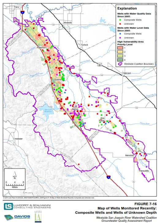
51 CASGEM
52 ILRP GAR

53 CVHM Study

54 Subsidence Study
55 GAMA
56 Data Management Approach Assess current data management setting within the basin Local data management activities and databases State and federal databases Other databases Identify DMS features that will help meet data management needs Evaluate costs and timeline associated with different DMS options Determine DMS platform Develop implementation plan Assess Data Management Setting Identify Desired Features Evaluate Costs and Timeline Determine DMS Platform Develop Implementation Plan
57 Data Management Systems Costs and Timeline DMS Options Estimated Cost Range Estimated Timeline Option 1: Off the shelf DMS (no modification) Includes configuration with little or no modification and potential license fees $5,000 $30, months Option 2: Off the shelf DMS (with modification) Includes configuration and modification to meet needs and potential license fees $10,000 $50, months Option 3: Custom developed DMS Includes design and development of a customized DMS and implementation at agency s location $100,000 $250, months Data Conversion (all Options) Includes data collection, conversion/qaqc, and upload to the DMS $10,000 $40, months
58 Central Valley Model Performance Change in Storage (AFY) 400, , , , , , CVHM C2VSim Gain from Stream (AFY) 400, , , , , , , , , , , ,000 0 Net Deep Perc (AFY) -100, CVHM C2VSim Pumping (AFY) 800, , , , , , , , CVHM C2VSim CVHM C2VSim
59 Adaptive Management 1. Decision Making Should reflect current level of understanding and anticipate future consequences of decisions Should consider management objectives, resource status, and knowledge of consequences of potential actions. 2. Follow up Monitoring Used to estimate resources status, underpin decision making, and facilitate evaluation and learning after decisions are made Ongoing activity 3. Assessment Monitoring data used along with other information to evaluate effectiveness of previous actions, understand resource status, and reduce uncertainty about management effects Model generated predictions are compared with data based estimates 4. Learning and Feedback Understanding gained from monitoring and assessment helps select future actions Iterative cycle of decision making, monitoring, and assessment leading to better understanding of resource dynamics and adjusted management strategy moving forward 5. Institutional Learning Periodically interrupt technical cycle to reconsider project objectives, management alternatives, and other elements of the setup phase
60 Success Criteria Development Criteria Water Budget Groundwater Balance Basin Stabilization Monitoring and Reporting Effectiveness Inter Agency Coordination Oversight and Management Tools and Actions Discussion Demonstrate that the overall surface and groundwater budget is in balance for the entire Basin. Establish a long term basis for determining groundwater balance. Need to consider concept of conjunctive use, including increasing storage in wetter years and relying on banked groundwater in drier years. Evaluate the stability of the groundwater basin, and measure GSP performance through longterm monitoring of basin performance. Develop plan for total monitoring of water use, groundwater use, and changes in groundwater storage. Monitor inter agency coordination and cooperation. May include number of inter agency exchanges, cooperative projects or programs, etc. Develop tools to understand individual landowner as well as agency based water use, including groundwater pumping. Establish effective means of reporting and providing feedback to landowners, and providing basis for enforcement if necessary. Data Accessibility Communication Plan for Uncertainties Monitor ability of all interested parties to have access, as appropriate, to available data. Monitor outreach communications, and measure the effectiveness thru a feedback loop. Develop an emergency/drought response plan, including triggers for various management or other actions.
61 Alternatives for Cost Allocation Independent Formula Development Identify allocation factors and assign weights or percentages. Other possible factors to be considered in formula development include: Frequency and timing of allocations and distributions Measures of need and fiscal capability Likelihood of obtaining outside funding Income as a measure of capacity to pay Assessable income of members with large populations by the percentage difference between capita income and a per capita income threshold corresponding to the average per capita income Maximum and minimum rates of assessment Per capita ceiling A cap of pre determined percent of total expenditures Scheme of limits designated to mitigate extreme variations in assessments Process by which formula application is adjusted in order to take account of relevant factors