PUBLIC INFORMATION MEETING Rahway River Basin Flood Risk Management Feasibility Study
|
|
|
- Alvin Woods
- 5 years ago
- Views:
Transcription


1 PUBLIC INFORMATION MEETING Rahway River Basin Flood Risk Management Feasibility Study COL Paul E. Owen District Engineer U.S. Army Corps of Engineers New York District New Jersey Department of Environmental Protection Non-Federal Sponsor 29 May 2014 US Army Corps of Engineers Photo By The Cranford Chronicle


2 Rahway River Basin Flood Risk Management Feasibility Study - Outline Background/History Flood Risk Management Alternative Formulation Process Alternatives Description Cost Estimates Economics Analysis Overview Questions? Photo By The Cranford Chronicle 2

3 Study Area The Rahway River Basin has a drainage area of approximately 82 square miles and encompasses Essex, Union, and Middlesex counties. The Rahway River consists of four branches: West Branch and East Branch originate in West Orange. They merge in Millburn to form the Rahway River which travels through Springfield, Cranford, and Clark into Rahway. The river receives water from Robinson s Branch and South Branch in the City of Rahway and enters into Linden and Carteret before flowing into Arthur Kill. Study focus areas are in Township of Cranford and City of Rahway along Robinson s Branch. 3
4 Background The most recent damaging floods of record within the Rahway River Basin were Tropical Storm Floyd in September 1999, the April 2007 Nor easter, and Hurricane Irene in August : USACE completed a Reconnaissance Report recommending a feasibility study to develop flood risk management alternatives within the Rahway River Basin. 2002: Feasibility Study Cost Share Agreement executed between the USACE and New Jersey Department of Environmental Protection (NJDEP) as the Non-federal sponsor. (50% Fed and 50% Non-Fed) 2006: Completion of an Initial Screening Report identifying Cranford Township and a portion of the City of Rahway along Robinson s Branch having greatest potential for Federal Interest. 4


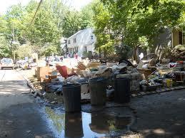
5 Hurricane Irene August


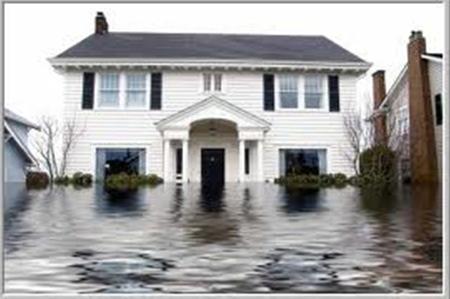
6 Hurricane Irene August
7 Flood Risk Management (FRM) No Flood Risk Management project can eliminate the risk of flooding. Given a long enough period of time, most projects will experience an event that is larger than the event which they were designed. Flood Risk Management (FRM) projects can only reduce the frequency and/or severity of flooding and provide additional time to respond. Physical features are only a single component of a flood risk management approach. Insurance, zoning and Emergency Action Plan (EAP) are some other important aspects of Flood Risk Management. Communication of accurate and timely information about the risk of living in a flood prone area is critical and best implemented at the local level. Flood safety is a shared responsibility and a collaborative approach is required to effectively manage the risk of flooding and to save lives. (Corps, FEMA, State, County, Local Gov., Emergency Personnel, Residents) 7
8 USACE Alternative Formulation Process for Feasibility Studies Identify Flood Risk Management (FRM) Alternatives Screen FRM Alternatives for Effectiveness Evaluate Alternatives Compare reduced damages of proposed alternatives against Without Project conditions at different flood stages. Perform Initial evaluation of Environmental Impacts Select & Optimize Plan Establish Tentatively Selected Plan (TSP) Determine National Economic Development Plan (NED) 8
9 USACE Alternative Formulation Process Cont. No alternative s analysis is complete until the following evaluations are conducted: 1. Hydrology & Hydraulics - Completed Model existing and improved conditions of the project area, including flows and water surface elevations Perform Risk and Uncertainty Analysis 2. Cost Estimates - Completed Screening based on quantities and cost estimates 3. Economic Justification for Plan Selection - Completed Benefit Cost Ratio >1, maximum net benefits 4. Environmental Impacts Cultural Resources, HTRW, Biological and Habitat considerations 5. Social Consequences Community impacts (e.g. displacement, recreational feature/business loss or gains) 9
10 Township of Cranford & the City of Rahway Township of Cranford: Completed work includes surveys, existing conditions analyses including hydrology and hydraulics, initial environmental and cultural resources investigations. Formulation of ten flood risk management alternatives for Cranford and upstream communities. Completed cost estimate for all the alternatives. Completed economic analysis and developed Benefit to Cost Ratios (BCR). City of Rahway along Robinson s Branch: Completed work includes surveys, existing conditions analyses including hydrology and hydraulics, initial environmental and cultural resources investigations. The Corps met with the City of Rahway officials to discuss possible alternatives for the Robinson s Branch. Formulating flood risk management alternatives for the Robinson s Branch 10
11 Photo By The Cranford Chronicle Alternatives 11
12 Rahway River Basin Flood Risk Management Feasibility Study Summary of Damages, Benefits, and BCRs Alternative 1. Channel work in and modification to Lenape Park 2. Channel work and modification to the Nomahegan levees and Lenape Park 3. Channel work dredging Orange Reservoir 4. Channel work and new outlet at Orange Reservoir 5. Channel work and South Mountain Regional Detention Basin 5a. Channel work and South Mountain Regional Detention Basin with relocation of Brookside Dr. 6. South Mountain Regional Detention Basin 6a. South Mountain Regional Detention Basin with relocation of Brookside Dr. 7a. Nonstructural - 10-yr floodplain in Cranford 7b. Nonstructural yr floodplain in Cranford Flood Damages Without Project With Project Annual Benefits Total First Cost Total Annual Cost Net Excess Benefits $9,459,920 $6,857,920 $2,602,000 $91,123,800 $4,395,000 -$1,785, $9,459,920 $6,856,170 $2,603,750 $90,816,400 $4,371,900 -$1,768, $9,459,920 $4,724,560 $4,735,360 $230,303,500 $11,532,400 -$6,797, $9,459,920 $5,018,850 $4,441,070 $68,871,200 $3,343,800 $1,097, $9,459,920 $2,830,780 $6,629,140 $164,005,100 $8,229,400 -$1,600, $9,459,920 $2,830,780 $6,629,140 $174,019,275 $8,655,100 -$2,025, $9,459,920 $3,948,960 $5,510,960 $108,472,500 $5,202,500 $308, $9,459,920 $3,948,960 $5,510,960 $115,724,023 $5,527,000 -$16, $9,459,920 $8,472,270 $987,650 $15,543,000 $667,400 $320, $9,459,920 $7,248,320 $2,221,600 $188,344,100 $8,157,800 -$5,946, BCR 12
13 Rahway River Basin Flood Risk Management Feasibility Study Alternatives (Cranford) Alt. 1 - Lenape Park Detention Basin with Channel Improvements Alt. 2 - Lenape Park Detention Basin, Nomahegan Park Levee Modification with Channel Improvements Alt. 3 - Channel Improvements and Dredging of Orange Reservoir Alt. 4 - Channel Improvements and minor modification to Orange Reservoir Alt. 5 - South Mountain Dry Detention Basin and Channel Improvements Alt. 5a Modified South Mountain Dry Detention Basin and Channel Improvements (relocation, road work, bridge) Alt. 6 - South Mountain Dry Detention Basin (stand alone) Alt. 6a Modified South Mountain Dry Detention Basin (relocation, road work, bridge) Alt. 7a Non-Structural Plan 10-year floodplain Alt. 7b Non-Structural Plan 100-year floodplain 13
14 Alternative #1: Lenape Park Detention Basin & Channel Improvements Description: Modification Lenape Park dam/levee system. Approximately 9,500 ft of levee will be raised by 6 ft. Approximately 15,500 ft of trapezoidal channel improvements throughout the Rahway River in Cranford Township Two bridge replacements. Removal of Droescher s and Hansel Dam. Utility relocation. This plan has a 1% chance of annual exceedance (100 yr) in Cranford Township and a minimal reduction in water surface elevations (WSEs) for towns downstream of Cranford. Potential Environmental Considerations: Rahway River Parkway/North Cranford/Union County Park System Historic District Wetlands Green Acres Riverine and Riparian Habitat 14

15 Alternative #1: Lenape Park Detention Basin and Channel Improvements Lenape Park Levee & Dam Improvement Channel Work thru Nomahegan Park Proposed Floodwall Channel Work N Union Ave. Bridge North Ave. Bridge Droescher s Dam 15
16 Alternative #2: Lenape Park Detention Basin and Nomahegan Park Levee Modifications and Channel Improvements Description: Modification Lenape Park dam/levee system. Approximately 9,500 ft of levee will be raised by 6 ft. Modification to Nomahegan levees, raising approximately 9,300ft of levee and adding approximately 900 ft of floodwalls. Approximately 9,700 ft of trapezoidal channel improvements throughout the Rahway River in Cranford Township. Two bridge replacements. Removal of Droescher s and Hansel Dam. Utility relocation. This alternative is likely to contain the 1% chance of annual exceedance flood (100yr event) in Cranford Township. Potential Environmental Considerations: Rahway River Parkway/North Cranford/Union County Park System Historic District Wetlands Green Acres Riverine and Riparian Habitat 16

17 Alternative #2: Lenape Park Detention Basin and Nomahegan Park Levee Modifications and Channel Improvements Lenape Park Levee & Dam Improvement Nomahegan Park Levees & Floodwall Improvements Proposed Floodwall Channel Work N Union Ave. Bridge North Ave. Bridge Droescher s Dam 17
18 Alternative #3: Channel Improvements and Deepening Orange Reservoir Description: Dredging Orange Reservoir to increase storage capacity and add outlets. Approximately 15,500 ft of trapezoidal channel improvements throughout the Rahway River in Cranford Township. Two bridge replacements. Removal of Droescher s and Hansel Dam. Utility relocation. This alternative is likely to contain the 1%-2% chance of annual exceedance flood in the Cranford Township. Potential Environmental Considerations: Rahway River Parkway/North Cranford/Union County Park System Historic District Wetlands Green Acres Aquatic and Riparian Habitat 18
19 Alternative #3: Channel Improvements and Deepening Orange Reservoir Nomahega n Park Channel Realignmen t Excavation of Sediments in Reservoir Additional Outlet Pipe 19
20 Alternative #4: Channel Improvements and Modifying Orange Reservoir Outlet Description: New outlet 2-30 pipes at Orange Reservoir, with manual operation. Approximately 15,500 ft of trapezoidal channel improvements throughout the Rahway River in Cranford Township. Two bridge replacements. Removal of Droescher s and Hansel Dam. Utility relocation. This alternative is likely to contain the 1%-2% chance of annual exceedance flood in Cranford Township. The flow detention capacity of the Orange Reservoir will mitigate the increase in flow conveyance capacity obtained by deepening and widening the channel. Potential Environmental Considerations: Rahway River Parkway/North Cranford/Union County Park System Historic District Wetlands Green Acres Aquatic and Riparian Habitat 20

21 Alternative #4: Channel Improvement and Modifying Orange Reservoir Outlet Nomahegan Park Channel Realignment Additional Outlet Pipes 21

22 Alternative #5: Channel Improvement with South Mountain Reservoir (dry detention basin) Description: Approximately 15,500 ft of trapezoidal channel improvements throughout the Rahway River in Cranford Township Two bridge replacements Removal of Droescher s and Hansel Dam Utility relocation This plan includes a new dry detention structure in South Mountain Reservation just upstream of Campbell s Pond. The structures will be approximately 810 ft long by 75 ft high. A steel truss maintenance bridge across the spillway of the dam. This alternative is likely to contain the 1% chance of annual exceedance flood in Cranford Township. Additional benefits to municipalities upstream. Potential Environmental Considerations: Rahway River Parkway/North Cranford/Union County Park System Historic Districts/South Mountain Reservation Historic District Wetlands Green Acres Aquatic, Riparian and Upland Forest Habitat 22

23 Alternative #5: Channel Improvement with South Mountain Reservoir Nomahegan Park Channel Realignment 23
24 Alternative #5a: South Mountain Detention Basin (relocation, road and bridge modifications) and Channel Improvements Description Approximately 15,500 ft of trapezoidal channel improvements throughout the Rahway River in Cranford Township Two bridge replacements Removal of Droescher s and Hansel Dam Utility relocation This plan includes a new dry detention structure in South Mountain Reservation just upstream of Campbell s Pond. The structure will be approximately 810 ft long by 75 ft high. Relocation of approximately 3,000 ft of Brookside Drive and a steel truss maintenance bridge across the spillway of the dam. The alternative is likely to have a 1% chance of annual exceedance (100-yr event) in Cranford Township. Potential Environmental Consideration Rahway River Parkway/North Cranford/Union County Park System Historic Districts/South Mountain Reservation Historic District Wetlands Green Acres Aquatic, Riparian and Upland Forest Habitat 24
 and Channel")
25 Alternative #5a: South Mountain Detention Basin (relocation, road and bridge modifications) and Channel Improvements 25
26 Alternative #6: South Mountain Reservoir Standalone Description: This plan includes a new dry detention structure in South Mountain Reservation just upstream of Campbell s Pond. The structure will be approximately 810 ft long by 75 ft high. A steel truss maintenance bridge across the spillway of the dam. This alternative is likely to contain the 2% chance of annual exceedance flood (50yr-event) in Cranford Township. Additional benefits to municipalities upstream. Potential Environmental Considerations: South Mountain Reservation Historic District Wetlands Green Acres Aquatic and Upland Forest Habitat 26
27 Alternative #6: South Mountain Reservoir Standalone 27
28 Alternative #6a: South Mountain Detention Basin (relocation, road and bridge modification) Description: This plan includes a new dry detention structure in South Mountain Reservation just upstream of Campbell s Pond. The structure will be approximately 810 ft long by 75 ft high. Relocation of approximately 3,000 ft of Brookside Drive and a steel truss maintenance bridge across the spillway of the dam. This alternative is likely to have a 4% chance of annual exceedance flood (25-yr event) in Cranford Township. Potential Environmental Considerations: South Mountain Reservation Historic District Wetlands Green Acres Aquatic and Upland Forest Habitat 28

29 Alternative #6a: South Mountain Detention Basin (relocation, road and bridge modification) 29
30 Alternative #7a & 7b: Non-Structural 10-yr and 100-yr Plan Description: Non-structural measures are being finalized for approximately 700 structures contained in the 1% annual exceedance (100-yr event) and approximately 100 structures contained in the 10% annual exceedance (10-yr event) flood inundation areas for the Rahway River in Cranford. All structures will be treated to an elevation of one foot above the 1% annual exceedance event (100 year). Non-structural Measures Floodplain 10-yr 100-yr Dry Flood proofing 0 11 Wet Flood proofing Ringwall 1 37 Raise Buyout 2 41 Total of Structures Potential Environmental Considerations: Individual structures contributing Rahway River Parkway, Union County Park System and South Cranford Historic Districts 30

31 Rahway River Basin Flood Risk Management Feasibility Study Typical Channel Improvement South Orange, NJ, 30 wide, + retaining walls

32 Rahway River Basin Flood Risk Management Feasibility Study Typical Dry Detention Basin Vermont, 65 high, 1,500 long, 80 years old

33 Rahway River Basin Flood Risk Management Feasibility Study Typical Dry Detention Basin Lenape Park, Springfield/Cranford, NJ


34 Rahway River Basin Flood Risk Management Feasibility Study Typical Non-structural Measures Structure Elevation Wet Proof Dry Proof
35 Photo By The Cranford Chronicle Cost Estimates 35
36 Screening Level Cost Estimates Feasibility Study 1. At Feasibility level, Cost Engineering produces screening level estimates for each of the alternatives. These estimates include the following: Construction cost including: materials labor equipment cultural resource and environmental mitigation Lands and Damages (Real Estate) Planning, Engineering, & Design (PED) Construction Supervision and Administration (S&A) 2. The estimates also include contingency percentages from an Abbreviated Risk Analysis (Per ER , 26 Mar 93, Section 9.d.(3)) 36
37 Screening Level Costs for Rahway Alternatives Alternative Cost 1. Channel work and Lenape modification $ 91,123, Channel work and Lenape and Nomahegan modification $ 90,816, Dredging Orange Reservoir and Channel work $ 230,303, Minor modifications to Orange Reservoir and Channel work $ 68,871, South Mountain with Channel work $ 164,005,100 5a. South Mountain (road relocation) with channel work $ 174,019, South Mountain Standalone $ 108,472,500 6a. South Mountain (road relocation) Standalone $ 115,724,100 7a. Non-structural 10-yr $ 15,543,000 7b. Non-structural 100-yr $ 188,344,100 37
38 Photo By The Cranford Chronicle Economic Analysis Overview 38
39 Economic Analysis Overview Identify and generate floodplain Inventory structures and gather key data Valuation of Structures 39
40 Economic Analysis Overview Inundation Damages Structure and Content Infrastructure Automobile Other Damages Public Emergency Cost Traffic Delay Cost Lost Income 40
41 Economic Analysis Overview Costs Initial Construction Costs Annual Operations and Maintenance Costs Benefits Annual flood damages reduced Benefit-Cost analysis is a comparison of the annual equivalent costs of the project versus the annual equivalent benefits from the project over a 50-yr period of analysis. Benefit to Costs Ratio must be greater than one (BCR>1) for a plan to be economically justified for Federal participation. A plan with the highest Net Benefits is the National Economic Development ( (NED) Plan 41
42 Rahway River Basin Flood Risk Management Feasibility Study Summary of Damages, Benefits, and BCRs Alternative 1. Channel work in and modification to Lenape Park 2. Channel work and modification to the Nomahegan levees and Lenape Park 3. Channel work dredging Orange Reservoir 4. Channel work and new outlet at Orange Reservoir 5. Channel work and South Mountain Regional Detention Basin 5a. Channel work and South Mountain Regional Detention Basin with relocation of Brookside Dr. 6. South Mountain Regional Detention Basin 6a. South Mountain Regional Detention Basin with relocation of Brookside Dr. 7a. Nonstructural - 10-yr floodplain in Cranford 7b. Nonstructural yr floodplain in Cranford Flood Damages Without Project With Project Annual Benefits Total First Cost Total Annual Cost Net Excess Benefits $9,459,920 $6,857,920 $2,602,000 $91,123,800 $4,395,000 -$1,785, $9,459,920 $6,856,170 $2,603,750 $90,816,400 $4,371,900 -$1,768, $9,459,920 $4,724,560 $4,735,360 $230,303,500 $11,532,400 -$6,797, $9,459,920 $5,018,850 $4,441,070 $68,871,200 $3,343,800 $1,097, $9,459,920 $2,830,780 $6,629,140 $164,005,100 $8,229,400 -$1,600, $9,459,920 $2,830,780 $6,629,140 $174,019,275 $8,655,100 -$2,025, $9,459,920 $3,948,960 $5,510,960 $108,472,500 $5,202,500 $308, $9,459,920 $3,948,960 $5,510,960 $115,724,023 $5,527,000 -$16, $9,459,920 $8,472,270 $987,650 $15,543,000 $667,400 $320, $9,459,920 $7,248,320 $2,221,600 $188,344,100 $8,157,800 -$5,946, BCR 42
43 Rahway River Basin Flood Risk Management Feasibility Study Approximate 100 year Comparison between Alternatives #4, #6 & #7 43
44 Photo By The Cranford Chronicle Next Steps 44
45 Feasibility Study - Next Steps Preliminary Alternatives Analysis including cost estimates for Robinson s Branch measures. Economic Analysis, Benefit-to-Cost Ratio for Robinson s Branch measures. Basin wide determination and optimization of Tentatively Selected Plan for Cranford measures & Robinson s Branch measures (TSP) NEPA Scoping Meetings Conduct Environmental and Cultural Resources Field Investigations Develop Real Estate Plan Prepare a Feasibility Report and NEPA Documentation (Environmental Impact Statement) Public and Agency Reviews 45
46 FY14 Rahway River Basin Flood Risk Management Feasibility Study - Next Steps Public Information Session for Cranford Measures Continue existing conditions on Robinson s Branch FY15 (contingent upon funding) Alternatives Analysis for Robinson s Branch measures Economic Analysis for Robinson s Branch measure Basin wide determination and optimization of Tentatively Selected Plan (TSP) for Cranford measure & Robinson s Branch measure NEPA Scoping Meetings Conduct Environmental and Cultural Resources Field Investigations FY 16 and Beyond Draft Feasibility Report Recommend a project for construction to USACE HQ and subsequently to Congress Congressional authorization and funding Complete Plans & Specs and initiate construction 46

47 Photo By The Cranford Chronicle Questions? 47

48 Contacts Rifat Salim Project Manager U.S. Army Corps of Engineer, New York District rifat.salim@usace.army.mil John Moyle, P.E. Chief of Dam Safety & Flood Control NJ Dept of Environmental Protection John.Moyle@dep.state.nj.us Photo By The Cranford Chronicle 48