Environmental Protection Update Stormwater and Floodplain. February 2, 2017
|
|
|
- Myron Glenn
- 5 years ago
- Views:
Transcription


1 Environmental Protection Update Stormwater and Floodplain Glen Behrend, P.E GA Zoning Conference February 2, 2017
2 INTRODUCTION Today s discussion: Stormwater Overview Stormwater and Smart Growth Opportunities Floodplain Management Overview Opportunity for Questions and Answers
3

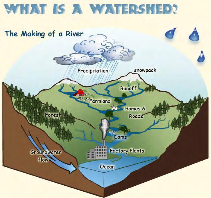
4 CHANGES IN RUNOFF AND INFILTRATION

5 STORMWATER AND THE LAND SURFACE Irrigation Water Management: Training Manual FAO.org
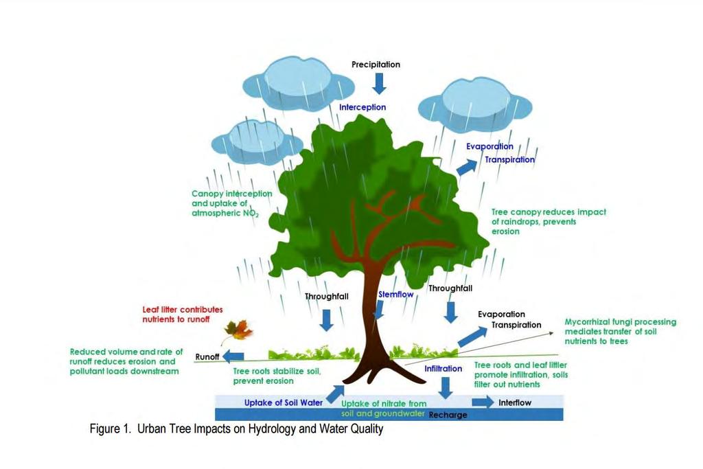
6 STORMWATER AND TREES
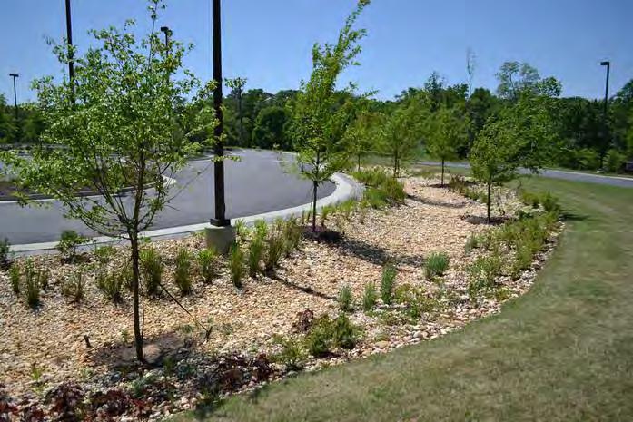
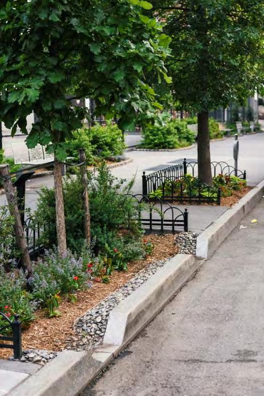

7 GREEN INFRASTRUCTURE AND LOW IMPACT DEVELOPMENT
8 EPA SMART GROWTH GUIDEBOOKS Purpose: Identify the most common code and ordinance barriers communities face and to suggest actions communities could take to improve their land development regulations.
9 URBAN AND SUBURBAN ZONING FOR SMART GROWTH


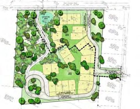
10 MIXED USE ZONES Problem Separating uses increases distances residents must travel increases impervious surfaces consumes land inefficiently Expected Benefits Reduced impervious surface More greenspace possibilities Efficient use of infrastructure

11 MIXED USE ZONES Steps to Implementation Modest Define Mixed Use centers in land use plans Permit residences in the upper floors of commercial areas Major Modification Create special zoning districts to allow mixed use without re-zoning Designate mixed use Districts on zoning map Wholesale Changes Synchronize zoning codes and area plans to coordinate ƒthe location and development of mixeduse districts

12 LOW IMPACT DEVELOPMENT REDUCED PAVEMENT Problem Conventional zoning requires dimensions that correspond to low intensity development increases impervious surfaces consumes land inefficiently Expected Benefits Reduced impervious surface More greenspace possibilities Efficient use of infrastructure Potentially more attractive walkable/bike-able community

13 LOW IMPACT DEVELOPMENT REDUCED PAVEMENT Steps to Implementation Modest Increased Floor Area Ratio (FAR), lot width and areas changes, smaller yards, increased heights, etc. Allow residential over retail Eliminate unneeded landscape buffer requirements no need to buffer like uses. Major Modification Create and incentive program for different housing types Adopt context-based neighborhood standards Create Districts for new compact development types Wholesale Changes Consider creating a computer model of the existing versus proposed changes Coordinate new dimensional standards with zoning map changes Modernize street standards

14 FIX PARKING LOT REQUIREMENTS Problem Conventional parking requires too much off-street parking and requires it to be provided on-site May not allow for offsite arrangement Large parking areas actually increase demand for parking by making people drive Provide right amount of parking at the right time Expected Benefits Reduced development costs Reduced impervious surface More greenspace possibilities Efficient use of infrastructure Potentially more attractive walkable/bike-able community


15 FIX PARKING LOT REQUIREMENTS Steps to Implementation Modest Create parking overlay districts allow shared parking, park once and allowance for alternative transportation Work with public works to increase available on street parking Evaluate parking specifications and reduce if possible Major Modification Develop a system of shared parking credits Revise parking minimums to reflect context, transportation options, and land use mix. Allow credit for on street parking in dense areas Wholesale Changes Consider bundling transit passes with parking passes to increase transit usage Consider requiring a portion of parking areas to be pervious

16 DESIGNATE AREAS FOR GROWTH AND DEVELOPMENT Problem Land use and growth has traditionally been handled reactively Has caused inefficient use of land and loss of greenspace Expected Benefits Reduced overall development costs Reduced impervious surface More greenspace possibilities Efficient use of infrastructure Potentially more attractive walkable/bike-able community


17 DESIGNATE AREAS FOR GROWTH AND DEVELOPMENT Steps to Implementation Modest Identify and map preferred areas in comp plans Establish utility and transportation capacity plans Designate agricultural zones in lieu of low density zoning in areas where the municipality would prefer to not see development Major Modification Vary Fees for development locations Establish criteria for annexation Wholesale Changes Establish urban service areas Rezone designated growth areas as part of urban service area plans

18 USE GREEN INFRASTRUCTURE FOR STORMWATER Problem Many local ordinances besides stormwater regulations pose barriers to better stormwater management and watershed protection. Communities must also look beyond the site scale and consider the impacts of where and how development occurs across neighborhoods and watersheds. Expected Benefits Reduced stormwater volume and flooding Reduced impervious surface Improved water quality Reduced urban heat island Increased land values Development attraction

19 USE GREEN INFRASTRUCTURE FOR STORMWATER Steps to Implementation Modest Allow green infrastructure stormwater management alternatives in zoning and subdivision regulations Coordinate with Stormwater Dept on water quality score card which was done as part of the MS4 permit. Incentivize green infrastructure with zoning upgrades, etc. Use early site planning meetings to plan for Stormwater Major Modification Change building codes to ensure Green infrastructure is allowable Incentivize Stormwater Management with Stormwater Utility Fees Wholesale Changes Amend stormwater regulations to allow for off site stormwater management, especially for infill/redevelopment Require bonds to ensure proper maintenance of stormwater Infrastructure
20 RURAL SMART GROWTH

21 URBAN EDGE DEVELOPMENT Problem Urban Edge areas can be too dense to maintain a truly rural character, but lack amenities and adequate infrastructure or are served inefficiently Expected Benefits Lower infrastructure costs Reduced impervious surface Improved water quality Improve opportunities for future redevelopment

22 URBAN EDGE DEVELOPMENT Steps to Implementation Modest Adopt comprehensive plans that encourage sustainable development patterns. Determine areas of growth and areas for preservation Amend zoning ordinances to repeal zoning districts that allow unsustainable densities on the outer edge Develop design regulations that require connectivity and integration with adjacent neighborhoods and create transitions to open space/agriculture Major Modification Require minimum densities in areas targeted for growth Require cluster/conservation subdivisions at the transition to rural Require fiscal and mitigation impacts. Require developments to pay their way. Wholesale Changes Preserve agriculture by zoning for agriculture only districts Encourage multi-jurisdiction land use coordination for location and size controls.

23 USE WASTEWATER INFRASTRUCTURE THAT MEETS DEVELOPMENT GOALS Problem The design and location of a community s wastewater infrastructure can affect its future development patterns, natural and agricultural areas, and health of watersheds. Addressing failing system Planning for growth Expected Benefits Lower infrastructure costs by aligning water infrastructure and land use Capacity for growth Improved water quality Protect public health

24 USE WASTEWATER INFRASTRUCTURE THAT MEETS DEVELOPMENT GOALS Steps to Implementation Modest Establish processes to align water infrastructure investments with other public investments such as transportation, housing, and schools Identify excess capacity in existing infrastructure so that development can be directed to areas that can support additional growth, making the most of infrastructure investments. Revise local regulations if necessary to allow the range of decentralized systems that are able to meet performance standards consistent with local water quality goals and land use plans Major Modification Delineate growth areas and designate these areas for new infrastructure Require developments outside growth areas to finance their wastewater systems Charge impact fees Wholesale Changes Encourage multi-jurisdiction wastewater planning for decentralized systems Develop a decentralized system policy for permitting, replacing failing systems, and identifying where centralized treatment is warranted.

25 PROTECT AGRICULTURAL AND SENSITIVE NATURAL LANDS Problem Rural local governments know that working lands, farms, prairies, forests, and rangelands are central to both their heritage and their economic future. Developing supportive policies, land use regulations, and zoning that can help keep families on the farm and prospering. Expected Benefits Preserve natural resources and working lands Support Agro- and Eco-tourism Support long-term sustainability


26 PROTECT AGRICULTURAL AND SENSITIVE NATURAL LANDS Steps to Implementation Modest Identify and map sensitive natural resources Limit capital improvements in sensitive areas Establish government service boundaries Provide tax relief or freeze for rural properties Major Modification Enact buffer setbacks from waters and natural areas Hire staff or consultants to review biological impacts of development proposals Purchase key sites for land trust or conservation easement Consider Transfer of Development Rights program Adopt agricultural workplace zoning Wholesale Changes Develop a resource protection master plan and incorporate it with the comp plan Create funding for open space acquisition such as bond or user fee Require restoration of degraded habitat on development sites or fee in lieu funds

27 Floodplain Management Overview 2017 GA Zoning Conference Date: 2/2/2017 Presented by: Glen Behrend Program Manager, Non-Point Source Georgia Department of Natural Resources Environmental Protection Division

28 Key Definitions Special Flood Hazard Area (SFHA) is an area of high flood risk that is inundated by the 1% annual chance flood sometimes referred to as the 100-year flood or base flood. A "Regulatory Floodway" means the channel of a river or other watercourse and the adjacent land areas that must be reserved in order to discharge the base flood without cumulatively increasing the water surface elevation more than a designated height. 28
 2. Amount of wave setup 3. Wave height above storm surge (SWEL) elevation 4.")
29 Key Definitions Cont d Base Flood Elevation (BFE) is the computed elevation to which floodwater is anticipated to rise during the base flood. In coastal areas the BFE comprises: 1. Storm surge stillwater elevation (SWEL) 2. Amount of wave setup 3. Wave height above storm surge (SWEL) elevation 4. Wave runup above storm surge elevation (where present)

30 National Flood Insurance Program NFIP The NFIP is a federal program enabling property owners in participating communities to purchase flood insurance as protection against flood losses Requires state and local governments to enforce floodplain management ordinances that aim to reduce future flood damage. Specific regulatory requirements for: Building in SFHA Building in Regulatory Floodway Elevating Building at or above BFE 30

31 Role of State The State of Georgia entered into a Cooperating Technical Partner (CTP) agreement with the Federal Emergency Management Agency s (FEMA s) Region IV in August State of Georgia assumes responsibility for the development and updating of the flood hazard maps known as Flood Insurance Rate Maps, or FIRMs on a countywide-basis for all 159 counties in the State 31

32 Why Update Maps Flood risk changes over time To gain a complete and current picture of flood risks. This helps community: Plan for the risk Communicate the risk to your citizens Take action to reduce flood risk to lives and property Build smarter and safer

33 Flood Zones Zone V Areas along coasts subject to inundation by the 1-percent-annual-chance flood event with additional hazards associated with storm-induced waves 3 ft. and greater Coastal Zone A - Areas along coasts subject to inundation by the 1-percent-annual-chance flood event with additional hazards associated with storm-induced waves between 1.5 ft. and 3 ft. Zone A Areas subject to inundation by the 1% annual chance flood. Zone X Shaded Area of moderate flood risk or 0.2% annual chance flood. Zone X Unshaded - Area of low flood risk

34 Community Assistance Program The Floodplain Unit also receives FEMA funding to provide community outreach and assistance through a structured Community Assistance Program 34

35 Georgia Flood M.A.P. Program Transitioning State Program to align with FEMA s Risk MAP Program Increase focus on risk assessment and planning Continue partnerships with Federal, State, and Local Agencies Acquire and utilize high accuracy topo data Deliver risk products and datasets Enhanced Outreach Program Outreach Guidebooks Increased Community Engagement Robust Website

36 Flood Risk Snapshot 36


37 Guidebooks Flood Map Outreach Planning Guidebook for Local Governments 37

38 Guidebooks Flood Response Toolkit 38

39 Guidebooks Floodplain Management Quick Guide 39

40 Guidebooks Greenspace and Flood Protection Guidebook 40


41 Guidebooks Best Practices Guide: Community Disaster Resilience 41
42 Glen R. Behrend, P.E. Manager, Georgia EPD Nonpoint Source Program