Sustainable Watershed Management in Ganga river basin Using SWAT Model PRESENTED BY
|
|
|
- Lester Blair
- 5 years ago
- Views:
Transcription

1 Sustainable Watershed Management in Ganga river basin Using SWAT Model PRESENTED BY Dr N K Tiwary, Professor, Water and Land Management Institute, Patna, Bihar, India Sristi Singh, B.Tech, Computer Science
2 Introduction Rainfed areas constitute about two third of the total 142 million Hectare cultivated land in the country These rainfed areas contribute only 45% to the total food grains production whereas irrigated area which account for only one third of the cultivated area contribute 55% of the total food grains production. Very high priority has been accorded to the holistic and sustainable development of rainfed areas based on watershed approach. Sustainable Watershed Management using modern technology is the only solution for the problem of food security.
3 What is a Watershed? Watershed is a geo- hydrological area which drains through a common point into a stream or river. It is an ideal planning unit for conservation of soil, water & vegetation. A small watershed of a few hectares drains into a stream & forms part of a larger watershed, until the combined watersheds become a major river basin. Watershed Development projects are implemented on the basis of planning for Micro- Watersheds On an average a Micro-watershed has an area of around Ha. Watershed management is a holistic approach aimed at overall development of its natural, human and animal resources.
4 Watershed as a hydrologic unit Watershed as a hydrologic unit has been adopted for integrated development of any area. This is because of the fact that water is a basic element for survival of all the biological materials as well as non-biological activities. Hence, it has been perceived that development will be sustainable only when planning is made around water availability, harvesting and its efficient utilization.
5 A TYPICAL WATERSHED


6 Watershed Management ORISSA WATERSHED DEVELOPMENT MISSION BHUBANESWAR
7 Integrated Watershed Management (IWM) Background Large water resources development projects in India have adverse socio-economic and environmental consequences. The failure of such projects, contributed to indebtedness, raising economic pressure and jeopardising future development. Indiscriminate expansion of marginal lands and over-utilisation of existing water resources for irrigation. Traditional water harvesting systems have suffered sever neglect. This type of development not only called into question the adequacy of water resources schemes but triggered the urgent search for more effective and appropriate management strategies. Major response to follow Integrated Watershed Management Approach.
8 Sustainable Watershed Development and Management The four engineering and management tools for effective and sustainable development of water resources in semi-arid rural India: - Appropriate technologies Decentralised development system Catchment based water resources planning Management information system In past the efforts were more on the soil conservation and taking measures on the land where as we used to neglect the welfare of the land users. For sustainable watershed management there is need to integrate the social and economic development together with soil and water conservation
9 Integrated Watershed Approach IWM is the process of planning and implementing water and natural resources an emphasis on integrating the bio-physical, socio-economic and institutional aspects. Public Participation High Low Mainly water conservation Socio-economic with water conservation Socio-economic, water conservation, participation Public participation planning, design, implementation Project success Watershed development program Social issues are addressed through involvement of women and minority. Community led water users groups have led the implementation efforts.
10 Concepts and Principles of Integrated Watershed Management(IWM) Objectives: Water has multiples uses and must be managed in an integrated way. Water should be managed at the lowest appropriate level. Water allocation should take account of the interests of all who are affected. Water should be recognised and treated as an economic good. Strategies: A long term, viable sustainable future for basin stake holders. Equitable access to water resources for water users. The application of principles of demand management for efficient utilisation. Prevention of further environmental degradation (short term) and the restoration of degraded resources (long term).. Implementation Programs: Comprise an overall strategy that clearly defines the management objectives, a delivery mechanisms and a monitoring schedule that evaluates program performance. Recognise that the development of water resources may require research, to assess the resource base through modelling and development of DSS, and to determine the linkage between water resources and the impacts on environment, socio-economy. Ensure that mechanisms and policies are established that enables long term support.
11
12 Objectives.. Ensuring judicious resource utilization without disturbing the ecological balance for sustaining livelihoods of local communities Soil and Water conservation or Land and water management is the means but sustainable production systems are the ends Use of Hydrological modeling to quantify the impacts of watershed interventions
13 Watershed Development & Modelling Limited water resources,- more demand. Watershed is the basic scientific unit. Need for proper planning and management. Integrated watershed development approach Digital revolution Recent advances in watershed modelling - use of computer models, remote sensing and GIS.
14 WATERSHED Development Watershed Characteristics. Hydrology of watershed. Watershed (ha) 50,000-2,00,000 10,000-50,000 1,000-10, , Classification Watershed Sub-watershed Milli- watershed Micro-watershed Mini-watershed
15 WATERSHED Development Parameters of Watershed Size Shape Physiography Climate Drainage Land use Vegetation Geology and Soils Hydrology Hydrogeology Socioeconomics
16 WATERSHED MODELLING Watershed modelling steps 1. Formulation 2. Calibration/verification 3. Application Watershed model constitutes 1. Input function 2. Output function 3. Transform function
17 WATERSHED MODELLING ET Precipitation Interception Storage ET Surface Storage Surface Runoff Infiltration Interflow Direct Runoff Percolation Baseflow Groundwater Storage Channel Processes Fig Flowchart of simple watershed model (McCuen, 1989)
18 WATERSHED MODELLING General Classification of Models Broadly classified into three types Black Box Models: These models describe mathematically the relation between rainfall and surface runoff without describing the physical process by which they are related. e.g. Unit Hydrograph approach Lumped models: These models occupy an intermediate position between the distributed models and Black Box Models. e.g. Stanford Watershed Model Distributed Models: These models are based on complex physical theory, i.e. based on the solution of unsteady flow equations (SWAT Model)
19 IWA Modeling through Advanced Technologies


20 Water Conservation & Harvesting Total water management for sustainable development?.
21 Water Conservation Important step for solutions to issues of water and environmental conservation is to change people's attitudes and habits Conserve water because it is right thing to do!. What you can do to conserve water? Use only as much water as you require. Close the taps well after use. While brushing or other use, do not leave the tap running, open it only when you require it. See that there are no leaking taps. Use a washing machine that does not consume too much water. Do not leave the taps running while washing dishes and clothes.
22 Water Conservation Install small shower heads to reduce the flow of the water. Water in which the vegetables & fruits have been washed - use to water the flowers & plants. At the end of the day if you have water left in your water bottle do not throw it away, pour it over some plants. Re-use water as much as possible Change in attitude & habits for water conservation Every drop counts!!!


23 Rain Water Harvesting?. Rain Water Harvesting RWH- process of collecting, conveying & storing water from rainfall in an area for beneficial use. Storage in tanks, reservoirs, underground storagegroundwater Hydrological Cycle
24 Rain Water Harvesting?. RWH - yield copious amounts of water. For an average rainfall of 1,000mm, approximately four million litres of rainwater can be collected in a year in an acre of land (4,047 m 2 ), post-evaporation. As RWH - neither energy-intensive nor labourintensive It can be a cost-effective alternative to other wateraccruing methods. With the water table falling rapidly, & concrete surfaces and landfill dumps taking the place of water bodies, RWH is the most reliable solution for augmenting groundwater level to attain self-sufficiency


25 RWH Methodologies Roof Rain Water Harvesting Land based Rain Water Harvesting Watershed based Rain Water harvesting For Urban & Industrial Environment Roof & Land based RWH Public, Private, Office & Industrial buildings Pavements, Lawns, Gardens & other open spaces

26 Rain Water Harvesting Advantages 1.Provides self-sufficiency to water supply 2.Reduces the cost for pumping of ground water 3.Provides high quality water, soft and low in minerals 4.Improves the quality of ground water through dilution when recharged 5.Reduces soil erosion & flooding in urban areas 6.The rooftop rain water harvesting is less expensive & easy to construct, operate and maintain 7. In desert, RWH only relief 8. In saline or coastal areas & Islands, rain water provides good quality water
 [India-WRIS,")
27 Study Area Main River Basins of India showing the Ganga River Basin (Yellow-region) [India-WRIS, 2012]

28 Geomorphic Map of Ganga River Valley


29 Catchment Area of Bagmati a subwatershed of Ganga river basin = 1900 km 2 Case Study
30 Salient features of Bagmati watershed 1. Total Drainage Area upto Hayaghat 14,384 Sq Km 2. Drainage Area in Bihar 6500 Sq Km 3. Population in Bihar Lakh 4. Mean annual flows MCM 5. Average annual rainfall 1255 mm 6. Total length of main river in Bihar 394 Km 7. Cropped area in Bihar 5362 Sq Km 8. Tributaries: Lalbakeya(R), Lakhandei(L), Darbhanga- Bagmati(L), Old kamla(l), Hasanpur Bagmati(R)
31
32 Simulation of Watershed Interventions through Modelling Hydrological modelling can be used to measure the impact of watershed interventions on water and sediment yields. Integrated watershed management, typically involve interventions in order to bring about desirable changes. Interventions are in form of changes in landuse/covers like afforestation, development of pasture land, horticulture etc.; or alterations and additions to the landscape of watershed by creating structures like check dams, ponds etc. These watershed management activities affect the watershed hydrology (Calder 1999, Rao and Prasad 1997) especially with regard to water and sediment yields (Kothyari et al. 2002, Moehansyah et al. 2002, Bolton et al. 1991).
33 SIMULATING WATERSHED HYDROLOGY USING SWAT MODEL A 1. Resources Mapping using Geographical Information System 2. Assessment of water availability using SWAT MODEL 3. Developing Management Information System using web based water resource information system
34 Results and Discussions Model Set up for Study Area - Bagmati river basin (1) DEM SRTM (90 m resolution) Gauge Stations and Stream Networks (2) Landuse Global USGS (2 M) (3) Soil FAO Global soil (5 M) (4) Rain gauges /Temperature gauges IMD (5)Stream Gauges CWC (6) Rainfall data- IMD Data, Aphrodite Gridded rainfall data, real time rainfall data downloaded from websites 34
35 Watershed Delineation Steps SRTM DEM Stream Networks Sub-watersheds Map Mosaic or Masking if required Burning with help of known watershed and river network Fill Sinks Direction Flow Accumulation Network Extraction Drainage Network Ordering Final Basin Boundary and Drainage map Catchment Extraction 35


 Soil type Map")
36 Model Set up (In put Maps) HRU Map Study area: Bagmati river basin, Bihar, India Watershed area: ha. = km 2 Total number of sub-watershed: 32 (threshold level: ha) Number of HRU formation: 206 MULTIPLE HRUs LandUse/Soil/Slope OPTION :THRESHOLDS : 5 / 5 / 5 [%] Number of calibration points: 1 (Hayaghat) Soil type Map Land Use Map DEM 36/ 19
37 Model Set up for study area Data sets used The SWAT model requires data on terrain, land use, soil, and weather for assessment of inflows and outflows of reaches. Following datasets have been used for setting up of the SWAT model: (1) DEM SRTM (90 m resolution) (2) Landuse Global USGS (2 M) (3) Soil FAO Global soil (5 M) (4) Rain gauges /Temperature gauges IMD

38
39 Table-6.2 Soil properties Soil Details SEQN SNAM NLAYERS HYDGRP TEXTURE SOL_AWC1 SOL_K1 CLAY1 SILT1 SAND C LOAM C LOAM D LOAM C LOAM C LOAM D LOAM C LOAM D LOAM D CLAY_LOAM

40 Calibration - Output Discharge m 3 /s Days

41 Validation for monthly flow
42 Flow Hydrograph Daily Simulation Flow Hydrograph of Hayaghat of July-04 RF at Simra RF at Kathmandu 40.0 Discharge in cumecs RF at Nagarkot RF at Benibad RF at Hayaghat July Time in days 31-July HayaOBS HayaSim
43 Community participation and local capacity building Development of new village level institutions and local capacity building. Operation & maintenance of structures, regulation of financial matters, and conflict resolution.
44 Discussion Success interventions reside in integration of appropriate technical and managerial measures. People s participation in the entire process are most important. The benefits of water harvesting and water conservation definitely reached. Thus, IWM approach may be characterised by Community management built on existing social structure, Project management drawn from village level organisations, Joint forest management with community participation, Self-help water user groups and community based banking institutions. Limitation: 100% drought proofing for every water use can not be achieved.
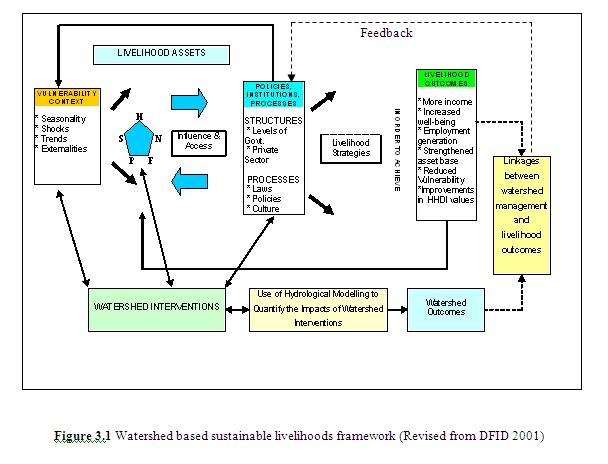
45 Concluding Remarks The integrated watershed management approach have the following major components: Promote sustainable economic development through optimum utilisation of natural resources and local capacity building. Restore ecological balance through community participation and cost affordable technologies for easy acceptance. Improving living conditions of the poorer through more equitable resources distribution and greater access to income generating activities by integrating watershed based sustainable livelihood framework.
46 Integrated Water Resources Development and Management ( IWRDM) is recommended for sustainable watershed management Integration of - - River basin resources- surface and ground. - Demands - consumptive and non-consumptive, and supplies. - Facilities - mega to micro. - Human and eco-systems. - S&T and engineering with social, economic, synergic needs.
47 END THANK YOU