2015 ASFPM Conference Atlanta, Georgia
|
|
|
- Laurence Lucas
- 5 years ago
- Views:
Transcription


1 2015 ASFPM Conference Atlanta, Georgia No Adverse Impact Floodplain Mgmt., Natural & Beneficial Functions of Floodplains, and the Cost of Community Services: Not All Lands are Suitable for All Purposes
2 CAPTAIN JIM MICKEY Somerset Reading Township FIRE &EMS CF, FF2 / EMT / Wildfire, CFM, Haz Mat Technician, Ohio Certified Prescribed Fire Manager, IC / SO, OPSI Fire & Rescue, EMT, Recreation Technician, Environmental Planner, Journalist, Ohio Adult Teaching Certificate, Ohio K-12 Sub Teacher Certificate, etc., etc., etc.
3
4 What is Emergency Management? Emergency Management = implement procedures to Reduce, Eliminate, Minimize, or Manage the impact of Emergencies, Disasters, or Other Events on our Citizens and Communities.
5 Emergency Management is a resource or a tool for our FIRST RESPONDERS (Fire/Rescue, EMS, Law Enforcement, etc.) to enhance the SCENE or INCIDENT STABILIZATION, LIFE SAFETY, and PROPERTY CONSERVATION of our Citizens and Communities in Emergencies, Disasters, and Special Events.
6 BACK TO THE BASICS: Four Phases of Emergency Management 1) MITIGATION 2) PREPAREDNESS 3) RESPONSE 4) RECOVERY
7 1) MITIGATION (pre event) Actions taken to Eliminate (Prevention) or Reduce the degree of LONG TERM RISK to HUMAN LIFE and PROPERTY (including Pets and Livestock) from any type of HAZARD.

8 Etc. Examples: MITIGATION Building Codes Public Education Risk Area Mapping Insurance Tax Incentives TORNADO SHELTERS FLOOD & WEATHER WARNING SYSTEMS


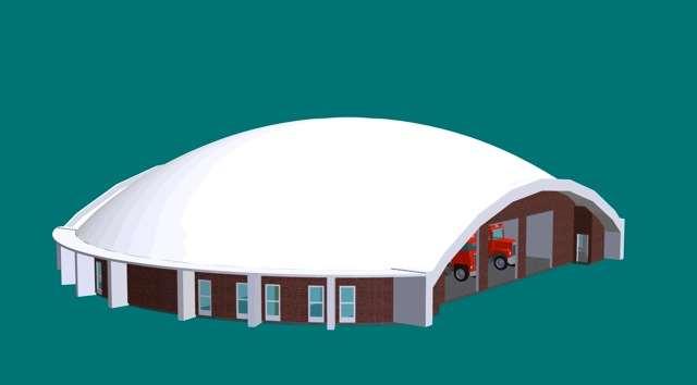
9 at Mobile Home Parks in Licking County Monolithic Dome Tornado/Severe Weather Community Shelters

10 The Monolithic Dome Tornado / Severe Weather Community Shelters are located to ensure rapid occupancy in an emergency.
11 OPEN DOME by Gary Clark (Monolithic Domes) - Residents of Summit Ridge Estates, a manufactured home development in Licking County, Pataskala, Ohio, don t worry too much about storms these days now that they have a their Monolithic Dome Storm Shelter / Community Center.
12
13

14
15 2) PREPAREDNESS (pre event) An Activity taken in Advance of an EMERGENCY or EVENT that Facilitates the Implementation of a COORDINATED RESPONSE.
16 PREPAREDNESS Examples: Hazard Identification Emergency Exercises Emergency Operations Plans Emergency Broadcast Systems/Sirens Advisory, Watch, Warning Trigger Points Continuity of Government Etc.
17


18
19 3) RESPONSE (during event) Action taken immediately Before, During, or After an EMERGENCY occurs, which Secures the Scene, SAVES LIVES, Minimizes Property Damage, and enhances the Effectiveness of Recovery.


20 RESPONSE Examples: FIRE/RESCUE/EMS ACTION STEPS Implement the EOP Activate the EOC Evacuation or Shelter in Place Etc.


21


22

23
24 4) RECOVERY (post event) Short Term Activity to return vital Life Supporting Systems to Minimum Operating Standards, and Long Term Activity to return the Community to Safe and Normal Levels of Activity.

25 RECOVERY Examples: Debris Management Damage Assessment Decontamination Disaster Assistance Temporary Housing Counseling Reconstruction Etc.


26


27
28 Summary: Back to the Basics: 4 Phases of Emergency Management 1) Mitigation 2) Preparedness 3) Response 4) Recovery
29 FLOOD WARNING SYSTEM Augmentation and Enhancement River Gauges and Rainfall Gauges improve our ability to predict and forecast flooding by measuring RIVER RISE: Rate Extent Depth RAINFALL: Duration Intensity Location Amount Also: monitor water quality parameters (DO, ph, temperatures, etc.), sediment loads,

30


31 SE Corner of Staddens Bridge, Madison Twp., Licking River SE Corner of Ridgely Tract Rd., Union Twp., South Fork Licking River Two Existing Stream Gauges prior to October 2007


32 USGS employees Al Dillenburg and Sandy Coen collect data to calibrate the Stream Gauges.
33


34

35


36 Interstate 70 and SR 79


37

38


39 Granville Stream Gauge, on Raccoon Creek, NE Corner of CR 539A bridge


40 Granville Village Water Treatment Plant


41 Flood of January 1959 in Granville


42 Present Day Granville

43 City of Newark Water Treatment Plant North Fork Licking River Critical Facility Stream Gauge


44 City of Newark North Fork Licking River, at the confluence of the South Fork Licking, which forms the Licking River
45 USGS Stream Gauges and a network of Rain Fall Gauges provide data to the National Weather Service (NWS) and Ohio River Forecast Center In Wilmington OH. This enhancement of Stream Gauges greatly increases the efficiency and accuracy of the NWS FLOOD ADVISORIES, WATCHES, and WARNINGS. The FLOOD FORECASTS provide TRIGGER POINTS that are relayed to our Licking County Homeland Security/Emergency Management/911 Center. This information initiates local and county ACTION STEPS by various Public Safety Services and other agencies and entities to better respond and: Secure the Scene, SAVE LIVES, Protect Property
46 FUNDING for the enhancement of the Flood Warning System Stream Gauge and Rain Fall Gauge Project was provided by: Cost Share Grants with USGS (Installation, as well as Operations and Maintenance) NRCS ODOT Licking County Commissioners Licking County Planning Dept. Fees City of Newark Village of Granville Granville Township Denison University Muskingum Watershed Conservancy District (MWCD)
47 GOALS BUCKEYE LAKE AREA These forecast points aid in the flood warning process for residents along the South Fork Licking River and into the Village of Buckeye Lake. It also enhances flood warning and activates established Trigger Points for ACTION STEPS for flood response actions and also detours along the I 70 / SR 79 corridor in the Buckeye Lake region (ODOT, Villages, Schools, LC HS/EMA/911 Center, etc.).
48 Buckeye Lake Area ACTION STEPS include: 1) ODOT PLAYBOOK for rerouting traffic due to I 70 & SR 79 flooding at South Fork Licking River 2) Evacuate or Shelter in Place Mobile Home Parks and Other Residents 3) Property Protection move vehicles from the area, move possessions to higher floors in homes, pets & livestock, etc.
49 GOALS GRANVILLE AREA This station provides continuous real time data, along with supporting a stage flow relationship from USGS, and a site specific Flood Forecast from NWS. Establish Trigger Points for ACTION STEPS tied to Flood Forecasts to protect various at risk facilities at various flood levels, including the Village Water Treatment Plant, the Power Plant for Denison University, Grocery Store, Gas Station, Lumber Company, etc.
50 Granville Area ACTION STEPS include: 1) Protect CRITICAL FACILITIES: Village Water Treatment Plant, the Power Plant for Denison University, Grocery Store, Gas Station, Lumber Company, etc. 2) Property Protection move vehicles, possessions, pets & livestock, etc.
51 GOALS City of Newark Establish an automated data and USGS Stage/Flow relationship to an existing high water forecast point along the North Fork Licking River (near the confluence with South Fork Licking River), to replace a manual gauge. (Flood Warning Trigger Points for a flood prone neighborhood area). Establish an additional gauge upstream to aid in flood control responsibilities and assist with discharge data for the forecast point down stream, and also benefit the more efficient operations of the Newark Water Treatment Plant.
52 Newark Area ACTION STEPS include: 1) Evacuate or Shelter in Place for Flood Prone Neighborhoods (ex: Little Texas, etc.) 2) Protect CRITICAL FACILITIES Water Plant 3) Install Flood Gates in Levee on South Fork Licking River National Drive, South Second Street, etc. 4) Property Protection move vehicles, possessions, pets & livestock, etc.
53 CHALLENGES Complexity of the various watersheds for data collection and flood forecasting, including the quick reacting Raccoon Creek, the slower reacting Licking River below the confluence of the North Fork and the South Fork, and the wild card influence of Buckeye Lake on the South Fork Licking River and the I 70 corridor.
54 SUMMARY Our ongoing Flood Warning System capabilities improvements helps: Secure the Scene, SAVE LIVES, Protect Property Improve our CRS Classification, and thus flood insurance discounts for our property owners, Ties in well with our overall Natural Hazards Mitigation Strategy, and thus enhance grant funding opportunities, Provide partnership opportunities with other agencies and entities.
55 WHAT IS NO ADVERSE IMPACT FLOODPLAIN MANAGEMENT??? Philosophy/Concept/Policy/Strategy of Land Use Mgmt. - Property Owner Actions (Public or Private) Does NOT Adversely Impact Property and the Rights of Others

56 ALL Potential Impacts of Proposed Land Use Changes or Development MUST be Determined. Also, ALL Properties the have the Potential to be Impacted by Land Use Changes Must be Identified.
57 Potentially Impacted Property Owners Need Notified MITIGATION Options to Ameliorate the Deleterious Impacts of Land Use CHANGES must be EVALUATED PRIORITIZED IMPLEMENTED to Insure NO ADVERSE IMPACTS on the many Functions of FLOODPLAINS, as well as any Flood Impacts on Neighboring Properties

58 NO ADVERSE IMPACT Development or Land Use Changes that could impact FLOOD DAMAGES to Other Properties of the Community. Allowable if IMPACTS of Development are MITIGATED or ACCOUNTED FOR with Appropriate Community Planning.

59 IMPORTANT CONSIDERATIONS: Prevention of Harm to Property Owners Increased COSTS to the Tax Paying Public For RESPONSE and RECOVERY Actions
60 Consistent with ASFPM Mission: NO ADVERSE IMPACT FLOODPLAIN MGMT. Seeks to MITIGATE the: LOSSES COSTS HUMAN SUFFERING Protect the NATURAL and BENEFICIAL FUNCTIONS which are typically difficult to account for and thus undervalued.
61 Current Floodplain Mgmt. Philosophy and Many Community Floodplain Regulations Tend to INCREASE RISK to PEOPLE and PROPERTY by: Promoting more Intensive Land Use or Developments within KNOWN RISK or HAZARD AREAS Ignoring Changing Land Use Conditions
62 Ignoring Adverse Impacts to Existing Property by Land Use Changes in the Community Discounting or Undervaluing the True Benefits of Natural Floodplain Functions
63 Remember: The FLOODPLAIN RISK or HAZARD AREA of TODAY is not typically the FLOODPLAIN RISK OR HAZARD AREA of TOMORROW, due to: CHANGING LAND USES DEVELOPMENTS within a Community and the Associated Watershed

64 If you live in the Floodplain, you are going to get your SHOES wet.

65 WHAT ARE THE COSTS OF COMMUNITY SERVICES??? Focus on How Various Types of Land USE Affects Local Gov t. TAXATION and SPENDING within a given COMMUNITY.
66 Analysis of TAXATION RECEIPTS and DISBURSEMENTS Determine whether Various Forms of LAND USE: RESIDENTIAL COMMERCIAL / INDUSTRIAL AGRICULTURE / FORESTRY OPEN SPACE Contribute or Detract from Local Community Gov t. Budgets
67 Typically, many Communities seek to attract Business, Commerce, Industry, and Residential Development under the Assumption that Economic Growth would Raise the Tax Base and Generate Increased Revenues for Local Infrastructure and Services, including: Roads Schools / Teachers FIRE / EMS / Law Enforcement.

68 But remember, Additional People and Property (Residential, Commercial / Industrial) REQUIRE Additional Public Safety Services, so ultimately, Does the INCREASED REVENUES Balance with the INCREASES DEMANDS for Infrastructure and Services???
69 COST of COMMUNITY SERVICES (COCS) is typically expressed as a Ratio for each Land Use Category: Residential Commercial / Industrial Agriculture / Forestry Open Space / Green Space
70 COCS compares how many DOLLARS worth of Local Gov t. Facilities (Roads, Bridges, Water, Sewer, Schools, etc.) and Services (Fire/EMS/LE, Teachers) are Demanded per DOLLAR Collected in TAXES PAID.

71 So, a COCS ratio of greater of 1.0 means that More than $1 is SPENT for Public Facilities and Services for Every $1 of TAXES COLLECTED
72 Virtually every COCS study indicates that for Residential Land, the COCS Ratio is substantially above 1.0, with averages ranging from 1.15 to So, $1.15 to $1.50 is spent on Residential Land PUBLIC FACILITIES and SERVICES for every $1.00 Collected in TAXES.
73 COCS ratios for Commercial / Industrial Lands range from 0.35 to 0.65, so $0.35 to $0.65 is spent for every $1.00 in Taxes Collected for this Land Use Type. COCS ratios for Agriculture / Forestry / Open Space typically range from $0.30 to $0.50 in Public Facilities & Services SPENDING for each $1.00 of TAXES Collected.

74
75 Basically, Commercial / Industrial and Agriculture / Forestry / Open Space Land Uses SUBSIDIZE Residential Land Uses in terms of TAX MONEY SPENT for Facilities and Services compared to TAX REVENUE COLLECTED.
76 SO, under our earlier premise that NOT ALL LANDS ARE SUITABLE FOR ALL PURPOSES, it becomes obvious that perhaps the Concept of highest and best use of Land for Residential Purposes may NOT be the Best Land Use for a Community after all, based on the COCS associated with conversion of Farm Land / Forests/ Green Space (including FLOODPLAINS and even other Natural HAZARDS High RISK areas) to Homes (Residential).


77 WHY ARE ALL LANDS NOT SUITABLE FOR ALL PURPOSES???


78 In particular, it makes little or no ECONOMICAL or ENVIRONMENTAL sense to Convert Productive Farms, Forests, and Recreational Areas, especially those located in Identified FLOOD HAZARD or RISK AREAS, to RESIDENTIAL Land Uses.
79 RESIDENTIAL LAND USE just does NOT typically Pay its Own Way, and may greatly Increase Community Costs for: Mitigation Preparedness Response Recovery after FLOOD EVENTS (or other Natural Hazard Events).
80 Take the opportunity to reflect on YOUR Own Community, and How these Concepts and Principles can be used to Implement or Enhance Land Use Philosophy and Regulations to Allow for Growth and Development in Your Community that is SECURE & SUSTAINABLE, and PROTECTED from the ECONOMIC and ENVIRONMENTAL Burdens of Development in FLOOD PRONE (or Other Natural Hazard) Areas.


81
82 Summary The Ultimate Mitigation Strategy & Tactic is to NOT put things at RISK of Known and Identified HAZARDS in the First Place, because NOT EVEYONE GETS A HELICOPTER RIDE. with LIBERTY and JUSTICE for ALL.

83
84 Many Thanks Questions, Comments, Concerns??? Prepare for the Worst, and Hope for the Best!!!
85
86 Captain Jim Mickey Somerset Reading Twp. Fire & EMS PO Box 473 Somerset OH

87