(Focus: Navigation & Boating Recreation impacts from water conveyance past, present and future)
|
|
|
- Drusilla Marshall
- 5 years ago
- Views:
Transcription

1 Sacramento river history (Focus: Navigation & Boating Recreation impacts from water conveyance past, present and future) Sacramento River, San Joaquin River, Steamboat Slough, Mokelumne River Presentation by Nicole Suard, Esq. for the Delta Protection Commission, to promote an understanding of the importance of navigation and boating recreation in the Sacramento San Joaquin Delta Region Video of slideshow is posted at


2 This presentation was made using historic reference maps and books owned or scanned by presenter, unless otherwise noted by provision of the online source of the map or data. Material is presented for educational purposes only. Photo of maps/books Purpose is to help the viewer understand the important history of the Delta s navigation, boating and other recreational benefits.

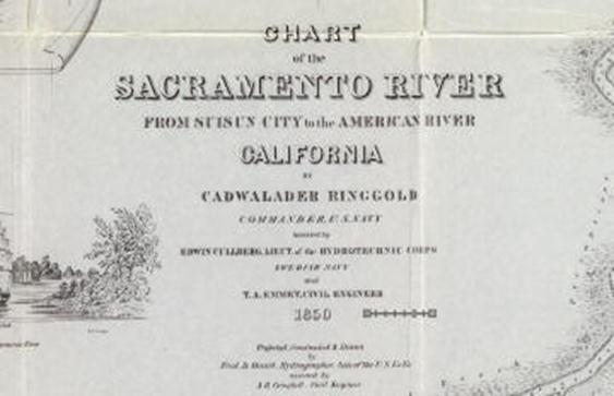
3 Ringgold Survey & Map

4 1855 Survey for the railroads


5 An enlarged view of the second section of the Middle Fork renamed Steamboat Slough very soon after the first survey in 1850, and an artists rendition

6 Steamboat Slough and Sacramento River in the 1860s-Hutchings California Magazine Hutchings


7 San Joaquin River 1850

8 As silting increased, snags increased, accidents increased and commercial shipping decreased


9 Mail traveled through Steamboat Slough via the Pony Express in


10 1873 Survey to PROMOTE the sale of Delta lands for reclamation and farming showing the country that may be irrigated and a provisional system of irrigation Ironically, this map is often used to mislead the viewer into thinking the map portrays the extent of tule marshes in the Delta-which was not the case at all!

11 1880 brought political pressure to ban hydraulic mining and protect the Delta s waterways Sketch below appears to be a 2002 rendition of the original cartoon which referred to the damage to the Sacramento River and also Steamboat Slough from hydraulic mining debris causing silting of the waterways.


12 Hall Maps of 1886 provide great details of the Delta Islands and Waterway names of the times Old Sacramento River, Steamboat Slough, San Joaquin River, and the islands actively irrigated are labeled. Note that the lower Central Delta islands are not defined in this series of HUGE and detailed maps.


13 Thompson s Dissertation and also the Pacific Historian report Reclamation records & revised waterways according to a different timeline than what is listed in the 2008 DRMS report


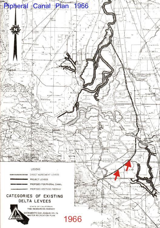
14 1906 San Joaquin River & Islands survey 1906 Survey of the San Joaquin River & surrounding islands: Practically all the land was originally tule or marsh land...much of it is unreclaimed. The sketch below is often used to convey the view of the entire Delta in 1870 when in fact it was the view of ONLY the San Joaquin River meandering to the port city of Stockton. Note the absence of trees and natural levees. The type of vegetation indicates the quality of fresh water there. Compare the landscape to that of the Sacramento River and Steamboat Slough of the same time period


15 1906 San Joaquin River & Islands surveydetailed view


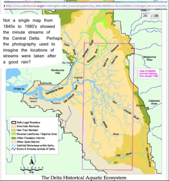
16 1906 Island Profiles-detailed view Note that the very detailed survey maps, shown in one foot increments with cross sections running across some of the major islands of the San Joaquin Delta area, do NOT show the intricate pattern or network of streams often portrayed in BDCP and SFEI maps. One has to question the purpose of BDCP in creating what appears to be a substantially misleading map compared to historical records:

17 1910 to 1930 s Central Delta reclamation and Sacramento River area road improvements further define the current Delta boundaries


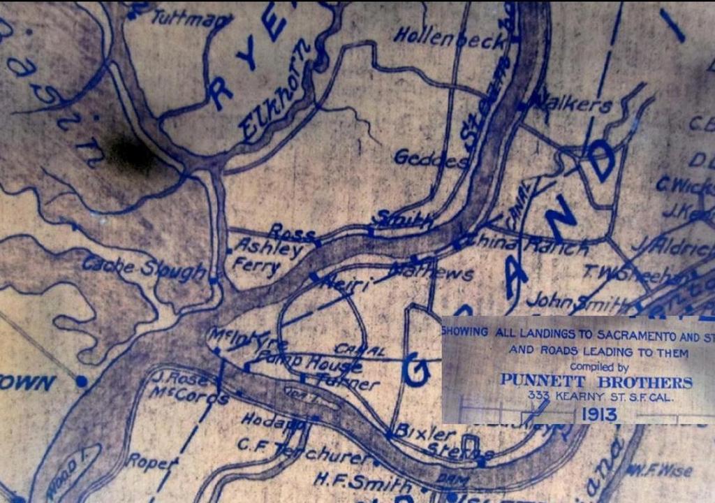
18 s travel on Delta Waterways

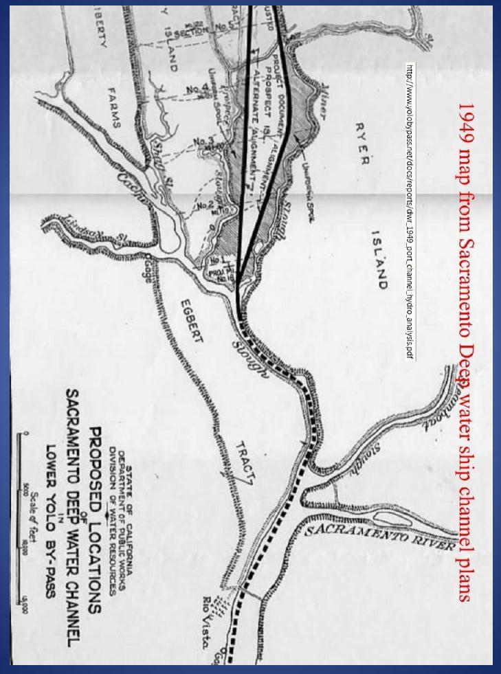
19 1935 Delta Soil Surveys Sacramento Deep Ship Channel
 http://www.deltarevision.")
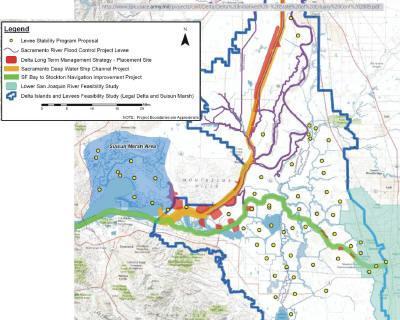
20 1945 Delta Cross Channel Plan (central conveyance to divert water to lower Central Valley dry lands)

21 Canal Planning


22 Other plans of the s
23

24 Canal Planning & Vote


25 Use of the Delta Waterways and Delta Islands for Flood Control Planning: Even though the waterways of the Delta have been silting in, the 2012 Flood Control plan used capacity estimates from the 1960 s, when the waterways were deeper. As a specific example, Sections of Steamboat Slough are now 10 feet deep where it was 17 to 20 feet deep before. More shallow waterway bed results in less capacity for flood control, logically. Maintenance dredging is needed for all natural Delta waterways at a minimum!


26 CALFED Preferred Alternative (central conveyance)
 will benefit the areas shown in the map above, left-but the")
27 Who gets the benefit of the water while the Delta counties and landowners suffer? Most of the Sacramento River diversion facilities under construction NOW (or already built in the last 10 years) will benefit the areas shown in the map above, left-but the majority of the new water diversions, if allowed, will benefit Southern California counties


28 Delta Studies and map gathering atwater/atwater-12-mokelumne.pdf
 of the flooded islands studies indicates the")

29 Examples of planning maps and studies: the 2003 map (to the right) of the flooded islands studies indicates the EDAW group was a bit confused about Delta island names! Other studies simply eliminate the Delta and its waterways

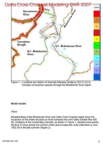
30 Starting about 2003 the volume of studies on flow and reoperation of the DCC had effects on boating


31 Negative effects of the Central Conveyance plan & limiting boating at the Delta Cross Channel Gates Example 1: DCC Reoperation or sudden closing of the Delta Cross Channel Gates to boater traffic on June 1, 2004: Boaters expecting to be able to return back to their berths via the DCC find the gates closed and must therefore go a day s worth of extra travel down the Sacramento River and back up into the Mokelumne River:


32 2000 to 2011 The names change but it s the same plan plus some extras


33 More Planning Maps!


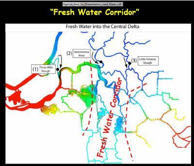
34 More Central Conveyance Plan names: Armored Aqueduct, BDCP Central Canal, Freshwater Corridor, In-Delta Storage, CALTRANS, NOAA, USGS and DOI Delta maps


35 More conveyance plans


36 2012: The Great Delta Trail is a great idea, but the 2006 DPC proposed boating trail limits some historic navigation waterways to non-motorized boating which would have a huge negative impact in the restricted areas NHA designation may even further restrict use of lands in the Delta, but that issue is not clear. In any case, NHA and the Great Delta Trail should show all useable roads around the Delta Islands to encourage tourism. After all, isn t that the purpose of developing a bike trail or historical sites trail?


37 While some agencies plan restoration of the Delta, CalTrans plans for the future transportation corridors for California, which appears to ELIMINATE Hwy 12 through the Delta, and Hwy. 160 may or may not continue as a scenic route by 2035.


38 2,500 CFS North of the Delta Sacramento River diversion projects under construction now: Folsom Dam changes and Folsom South Canal expansion Red Bluff Diversion & Fish Screen allows 2500 cfs diversion New fish screens that also increase freshwater diversions for new developments north and west of the Delta: See new Verona Fish Screen/intake for an example New water intakes for Sacramento area also divert additional new water away from Delta Flow Expansion of reservoirs and new resevoirs like the Sites plan would further limit flow into the Delta


39 Starting about 2002 different construction projects begin, each listed as regional project or fish screens or flood control but if you ignore the name and look at the function of the project, it is clearly part of the overall plan to divert most of the Sacramento River water.
 which diverts water from Folsom Dam so that as much as 300,000 cfs can be diverted away from the Delta when")

40 In the meantime, under EBMUD label a Delta bypass conveyance facility was built or is under construction: the Freeport intake facility, and the use of the Folsom South Canal expansion (USBR/DWR project) which diverts water from Folsom Dam so that as much as 300,000 cfs can be diverted away from the Delta when completed! *Past & current water flow tracking used inflow INTO Folsom Dam as the measure for a portion of Sacramento River Delta inflow. If water is now diverted from Folsom Dam before it ever reaches the I-street bridge, shouldn t that method of calculating Delta inflow be revised to reflect ACTUAL Delta inflow? 300,000 CFS

41 Combine the levee and dredging projects of the Coalition to Support Delta Projects, and it appears the expansion of the DCC to the 2000 CalFed preferred alternative will be completed status of the cross channel gates still undetermined!


42 BDCP & the 1945 Delta Cross Channel Plan: limits to navigation Basemap is a section of the June 2012 BDCP map Added to basemap: 1850 s Original navigation route to Sacramento 1850 s Alternate route to Sacramento-called Old River Sacramento on many historic maps 1945 Delta Cross Channel conveyance plan 2012


43 Possible effects on the North Delta area, based on 2008 BDCP 5,000 cfs to 9,000 cfs Sacramento River diversion study: Lower water flows will result in some natural waterways eventually silting in or becoming to shallow for navigation, unless dredging is planned. Lower freshwater flows will also allow higher saltwater encroachment into the Delta-way beyond historical records of natural encroachment.

44 * The planned increased diversions of Sacramento River water north of the Delta will already reduce Delta inflows before any BDCP intakes along the river are built. There just is not enough water flow on the Sacramento River to validate the expense of all the pumps planned or under construction now! To validate diverting more Sacramento River water away from the Delta, fish scientists have decided that a Delta with more variable high and low water flows will help the native fish. However, the possible negative effects on the human population in the Delta are alarming: Where the Delta once had maximum 1 ppt salinity encroachment in the North Delta the new X2 measurement uses 2 ppt-double the salinity! Increasing the high and low flow variability results in damage to the septic systems of the farms and residents of the Delta area because the leach fields are unnaturally inundated every 12 hours instead of only during high flood times (about once every 10 years in the North Delta) Pulse flows for the fish studies result in damage to the levees in some areas. Delta farming will become more regulated to be compatible with whatever the latest generation of environmental scientists determines should be the next experimental phase


45 2012 California s Water War rages on!
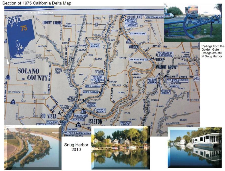
46 Links to Presentation maps and reports used in slides: Good websites to view historical maps of the Delta: davidrumsey.com DeltaREvision.com SnugHarbor.net (Steamboat Slough, Ryer and Grand Islands) snugharbor.net/images2012/maps/delta_waterways.pdf charts.noaa.gov/onlineviewer/18661.shtml Links to some of the agencies and organizations promoting revision of the Delta: Maps and presentation data compiled by N. Suard, Esq. Snug Harbor on Steamboat Slough September 2012

47 Note: If you are feeling confused because there are so many agencies and so many different planning areas, don t feel bad. Even the state gets confused too! Note how DWR missed an area to include in the new IRWM plans-isleton impacted!

48 Below is a map which overlays the boundaries of different agencies and the agency planning areas or jurisdictions. INCONSISTENCY is the one consistent theme for how agency boundaries were defined! Clearly, the designed inconsistency has a purpose.
49 Thanks for Watching! Don t Drain the Delta!