ESTIMATION OF SURFACE RUNOFF USING GEOSPATIAL TECHNOLOGY KOMBAI MICRO WATERSHED A CASE STUDY
|
|
|
- Jared Parks
- 5 years ago
- Views:
Transcription
1 Internationa Journa on Appied Bioengineering, Vo., No.1, Juy 008 ESTIMATION OF SURFACE RUNOFF USING GEOSPATIAL TECHNOLOGY KOMBAI MICRO WATERSHED A CASE STUDY Ramasubramaniam K., Pugazhendi V., Anitha A., Dawn S S 1 Research Schoar, University of Madras, Chennai, India Tami Nadu Water and Drainage Board, Chennai, India 3,4 Department Chemica Engineering, Sathyabama University, Rajiv Gandhi Road, Chennai, India 1 E-mai : purenviro@eth.net ABSTRACT Geospatia technoogy is being widey used for the assessment of natura resources. The present paper deas with the usage of geospatia technoogy for the estimation of surface runoff on a watershed basis. The Kombai micro watershed of Vaigai basin covers Sq.Km. The assessment of surface runoff is much necessary before taking up any kind of conservation measures. The Soi Conservation Services (SCS) method has been empoyed to assess the surface runoff from the micro watershed. The remote sensing data products has been used to prepare the and use and soi ayers. The GIS has been used to integrate the thematic ayers to estimate the surface runoff based on CN vaues. KEYWORDS : Surface water, Watershed, Geospatia technoogy, I. INTRODUCTION The sustainabe deveopment has been defined by the Word Commission of Environment and Deveopment in 1987 as deveopment that meets the need of the present without compromising the abiity of the feature generations to meet their needs (Pantuu 1996) Water in its natura hydroogica cyce is tapped for human activities from both the surface water and groundwater segments. The utimate source for a the water is precipitation. The surface and groundwater are in fu form during the monsoon and post monsoon periods and goes on depeting with time due to over expoitation for mutifaceted activities. In India the repenishment takes pace ony during the monsoon and after the monsoon period the stress on the water resources, both on surface and groundwater, is very high. The avaiabiity is very ow and the demand is high. With the above in mind the sustainabiity of water resource in particuar surface and groundwater has to be anaysed on watershed basis using geospatia technoogy and suggest measures for repenishment. METHODS OF ACHIEVING SUSTAINABILITY The sustainabiity can be achieved by enforcing a strong and effective monitoring network. An integrated water management system on watershed basis is necessary to attain the sustainabiity. Some of the scientific measures to ensure the sustainabiity are: Proper assessment of surface runoff on watershed basis Deineation of surpus and deficit watershed with respect to surface water. Inducing some artificia recharge measures in scientificay identified ocation. Geospatia technoogy such as, Remote sensing, Geographica Information System and Goba Positioning system can be empoyed to achieve the above. In the present paper a micro watershed has been taken up to estimate the surface water runoff, using geospatia technoogy. Kombai micro watershed ies in Vaigai basin. It ies between atitude of 9 43' 9 53 and ongitude of Kombai micro watershed comprises of Uthamapaayam bock of Theni district. The aeria extent of the watershed is Sq.Km. Of which Sq.Km in pains and Sq.Km in his (Figure-1) The main objectives of the study is To assess surface water runoff from the micro watershed using SCS Method. II. METHODOLOGY To achieve the above objective the foowing methodoogy has been adopted. Demarcation of micro watershed from 1:50000 SOI topo sheet. Digitization of micro watershed boundary and other cutura features. Digitization of streams according to the stream order. Preparation of Land use and Soi map from IRS 1D digita sateite data Using ERDAS Image processing software.
2 6 Ramasubramaniam et a : Estimation Of Surface Runoff Using Geospatia Technoogy... Coection and compiation of daiy rainfa data. Cacuation and integration of Land use, Soi map to obtain CN vaue usearcgis software. Estimation of surface runoff for daiy, monthy and yeary runoff based on Soi Conservation Services (SCS) method. The River Suthagangai odai originates from Kambam vaey reserved forest area. The drainage pattern of the micro watershed is parae to sub-parae and dendritic. Based on Straher method the drainage morphometric has been done. The drainage map and the stream order are presented in Figure - The micro watershed is formed of the Archean crystaine metamorphic compex. The rock types have experienced recurring tectonic and magmatic activities in the Precambrian period, which resuted in the compicated structure and geoogy. The rock types in the watershed incude Granite, Charnockite Garnet biotite gneiss and recent auvium. Geomorphoogy map has been prepared from IRS 1D LISS III digita sateite data using ERDAS Image processing software by hybrid interpretation techniques. Geomorphoogicay the watershed is comprises of Structura hi, residua hi, inear ridges, shaow pediment, buried pediment, pediment inseberg, bazada, and vaey fi. The ineaments act as conduits for groundwater movement. The ineament has been depicted from sateite data. Sope is one of the important topographica features for determining the infitration rate and runoff. Based on Ian Gabraith (1983) method, the sope has been prepared. The sope eucidates the sope variations in the micro watershed. The digita eevation mode is presented in Figure - 5 The micro watershed is covered by four hydroogic soi group such as, A,B,C,D. The soi series incudes Paaviduthi, Vyogam, Somayanur and Forest humic. The different soi series and the area of coverage by different soi series are presented in Figure-3 The and use map has been prepared form IRS 1D LISS III digita sateite data. The and use pattern of the micro watershed is presented in Figure-4. Neary 5 percentage of the area is covered by dry forming. The occurrence of ground water is restricted to weathered and fractured zone. Detaied geophysica survey and we inventory have been taken up in the micro watershed. The data reveas that the top soi varies from 4 to 8m weathering thickness varies from 7m to greater than m and the fractured zone varies from 8 to 18 m. The weathering thickness ranging from 7 to 1m is predominant in the micro watershed. The depth of the dug wes varies form 10 to 5m BGL and the depth of the bore wes varies from 40 to 10m. Depth to water eve data has been coected for pre and post monsoon seasons in seected wes. The pre monsoon water eve varies from 5.5 m to 8.5 m and the post monsoon water eve ranges from 3.5 m to 8.5 m. In some paces, the water eve depeted is beow weathered zone. Groundwater sampes from seected number of wes have been coected and tested for physica and chemica quaity of water. The quaity parameters such as, tota dissoved soids, SAR, and sodium percentage have been taken up for the anaysis. The quaity of groundwater in the study area is generay good. The nearest raingauge station of the study area is Uthamapaayam. The norma annua rainfa in the micro watershed is 790 mm. The 50 years norma rainfa indicates that the major contribution of rainfa is during north east monsoon, which is 44 % of the tota norma rainfa. Daiy rainfa data coected from the above rain gauge station have been taken for the anaysis and for runoff estimation. Runoff is one of the most important hydroogic parameter used in most of the water resources appications. The predication of quantity and rate of runoff from the and to the streams is very difficut and it requires more time for ungauged watershed. Rainfa, if it is not intercepted by vegetation of by artificia surfaces such as roofs or pavements, fas on the earth and either evaporates, infitrates or ies in depression storage. When the oss arising in these ways are a provided for, there may remain a surpus that, obeying the gravitation aws, fows over the surface to the nearest stream channe. The streams coaesce into rivers and the rivers find their way down to sea. Runoff may consist of surface runoff, subsurface runoff and groundwater runoff. Surface runoff is that part of runoff which traves over the ground surface and through channes into the basin outet. Subsurface runoff (Interfow) is that part of precipitation which infitrates the surface soi and moves ateray through the upper soi horizons towards the streams. Groundwater runoff is a portion of groundwater discharged into the streams.
3 Internationa Journa on Appied Bioengineering, Vo., No.1, Juy The surface runoff assessment is very essentia to quantify the water that fows out of the watershed. A portion of the surpus fow can be used for conservation with in the watershed. The conventiona methods of predication of runoff requires considerabe amount of hydroogica and meteoroogica data. The Remote sensing and GIS can hep to a great extent in runoff assessment. Though there are number of methods are avaiabe to assess the runoff from a watershed, The Soi Conservation Services (SCS) method has been deat eaboratey, since it is reiabe and more accurate than the other methods. The most generay avaiabe data in India are the amounts measured by non-recording rain gauges and for such data, Rainfa-runoff reationship was deveoped. Rainfa - runoff reationship, in genera form, is given as Q = (p-ia)/((p-ia) + S) Where Q= actua runoff, P = the rainfa S = potentia retention and Ia = initia abstraction during the period between the period of beginning of rainfa and runoff in equivaent depth over the Catchment. The effect of runoff is based on the antecedent soi moisture condition. The Soi Conservation Services has formuated three antecedent soi moisture conditions viz. AMC I, AMC II and AMC III before estimating runoff for a particuar rainfa event the curve numbers have to be adjusted according to the season and tota 5-day antecedent rainfa. ANTECEDENT MOISTURE CONDITION (AMC) Runoff curve number for hydroogic soi cover compex The Land use pattern of the watershed and the hydroogica soi group has to be considered to estimate the Curve number (CN vaue). The modified curve numbers foramc-ii are given beow in Tabe - 1. TheAMC I & AMC III have to be taken from the tabe for the runoff curve numberamc II. Tabe-1. Modified curve numbers for AMC - II CONDITION OF REGION Back soi region AMC II and III Ia = 0.1S Back soi region AMC I Ia = 0.3S A other regions Ia = 0.3S The S vaues are derived from the Curve Number (CN) vaues CN = 5400/(54+S) S = (5400/CN) - 54 Using the above equations deveoped are Q=(P-0.3S)/(P+0.7S).for a soi regions Q=(P-0.1S)/(P+0.9S).for back soi regions The and use / and cover map has been prepared from IRS 1C LISS III, digita sateite data has been prepared and the area of each and use unit has been cacuated and presented in Figure -4 The soi map has been prepared from the sateite data and from the existing soi map of the micro watershed. The soi map and the area of each hydroogica soi group is presented in Figure-3 The and use and soi map have been integrated using ArcGIS software and the integrated and use / soi attribute tabe has been used for the computation of tota area weighted curve number of the micro watershed (for AMC II) and from the above tabe the curve numbers for AMC I and AMC III conditions have been computed. (Figure-5)


, which requires more attention to improve the groundwater resources.")


4 8 Ramasubramaniam et a : Estimation Of Surface Runoff Using Geospatia Technoogy... Tabe-. Computation of Weighted curve number of Kombai watershed The runoff estimation using SCS method reveas that there is sufficient runoff potentia is avaiabe in the Kombai micro watershed. A portion of the runoff can be used for conservation measures in the micro watershed for sustainabe groundwater deveopment. III. CONCLUSION As far as the Kombai micro watershed is concerned, the surface water runoff is consideraby good and the groundwater resources is very ess (Over expoited), which requires more attention to improve the groundwater resources. Concusivey, the integrated watershed approach is essentia for assessing the surface runoff, groundwater potentia and for identifying artificia recharge potentia zones. The daiy rainfa data of Uthamapaayam rain gauge station has been coected for the year 1990 and 004 and the weighted curve number of the micro watershed has been given as input for the cacuation of daiy runoff. The daiy runoff of the micro watershed for the year 1990 and 004 is presented as tabes (Tabe 1&). The monthy runoff is presented beow. Tabe-3. Monthy Runoff Estimation for the year 1990 & 004 Fig.1 Kombai Watershed Base map Fig. Kombai Watershed Drainage


5 Internationa Journa on Appied Bioengineering, Vo., No.1, Juy Tabe-5. Area Covered for different anduse pattern Fig.3 Kombai Watershed Soi Tabe-4. Area Coverage Fig.5 Digita terrain mode of Kombai micro watershed Fig.4 Kombai Watershed Landuse Fig. 6 Kombai Watershed Landuse and Hydroogica soi group (Integrated)
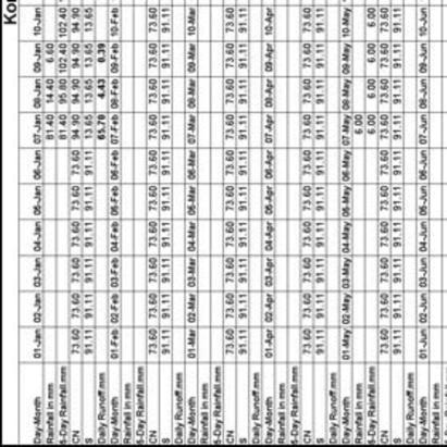
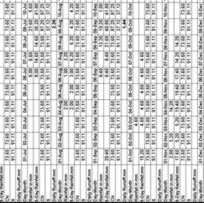

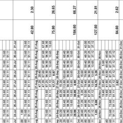
6 30 Ramasubramaniam et a : Estimation Of Surface Runoff Using Geospatia Technoogy... Tabe-1. Kombai Watershed - Estimation of daiy runoff for the year 1990


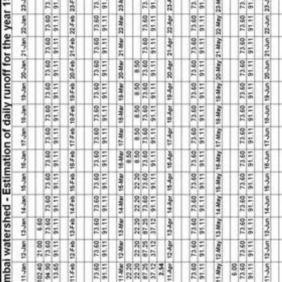
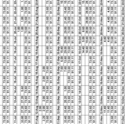
![the year 004 REFERENCES [1] David Keith](/docs-images/95/125766898/images/7-2.jpg "Todd, 1976 Ground water Hydroogy []")


7 Internationa Journa on Appied Bioengineering, Vo., No.1, Juy Tabe-. Kombai Watershed - Estimation of daiy for the year 004 REFERENCES [1] David Keith Todd, 1976 Ground water Hydroogy [] Wison,E.M Engineering Hydroogy [3] CGWB, 1994 Manua on Artificia recharge of ground water [4] Gurme Singh eta., 1990 Manua of Soi & water conservation practices Mr. Ramasubramaniam.K is a Research Schoar in the University of Madras. He has worked in various capacities reated to Environmenta Engineering and is he is activey working in fieds of Environmenta Impact Assessment and Air quaity modeing.