STANLEY FARM SUBDIVISION
|
|
|
- Caitlin Hubbard
- 5 years ago
- Views:
Transcription

1 STANLEY FARM SUBDIVISION SERVICING OPTIONS AND STORMWATER MANAGEMENT REPORT BRIEF CITY OF OTTAWA PREPARED FOR: STANLEY FARM DEVELOPMENTS PREPARED BY: (November Revision 0)
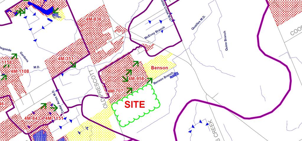
2 LOT 9, CONCESSION 5 WATER SUPPLY, SEWAGE, GRADING AND STORMWATER PRELIMINARY SERVICEABILITY STUDY TABLE OF CONTENT 1.0 BACKGROUND 1.1 General Existing Services PROPOSED SERVICES Water Supply Sewage Stormwater Management Site Grading CONCLUSION...4 APPENDIX A SK-1 Location Map Figure Greely/Shields Creek Stormwater and Drainage Study SK-2 Storm Drainage and Macro Grading Plan
3 Preliminary Serviceability Study Lot 9 Concession 5 November, 2014 PRELIMINARY SERVICEABILITY STUDY 1.0 BACKGROUND 1.1 General The subject property encompasses a total area of approximately hectares (98 acres) and is located within the south-eastern limits of the existing Village of Greely, Ontario on Lot 9, Concession 5, just East of Old Prescott Rd. and south of Donwel Dr. (see location map SK-1). The average minimum lot size for each of the proposed lots has been assigned at approximately 0.28 hectares (0.68 acres) with a total of 103 lots providing a lot density average of 0.38 ha (0.95 acres). Permissible minimum lot size within the former Village of Greely, as referenced by the City of Ottawa Official Plan (OP) is set for this site at 0.20 hectare (0.50 acre). It is proposed that the subdivision will be serviced by individual onsite wells and onsite wastewater treatment systems (OWTS). This form of servicing is consistent with the established hierarchy prescribed in Section of the Ontario Provincial Policy Statement and is consistent with the established development within the Village of Greely and surrounding rural areas. 1.2 Existing Services This area of development in Greely has no existing sanitary, watermain and storm sewers to services this proposed subdivision. Therefore, this rural development will be constructed as follows: - All dwellings will have their own: 1. wells for domestic water usage 2. septic systems for sewage treatment - Roadside ditches and culvert crossings will be proposed and sized to accommodate the 10yr storm as a minimum to drain the lots and roads - Two stormwater management ponds are proposed to ensure that the pre to post conditions of the site are respected after development. - An internal Village Road Network as shown in the Village of Greely Community Design Plan, Schedule C is being proposed which will provide Page 1
4 Preliminary Serviceability Study Lot 9 Concession 5 November, 2014 this subdivision with two connection access points, one by Old Prescott Rd., the second by Donwel Dr. Two other future road linkages have been proposed, one to the South and the other to the East. - Hydro, Bell Cable and Gas was not part of this preliminary serviceability study; it should be verified prior to proceeding with the first design submission. 2.0 PROPOSED SERVICES 2.1 Water Supply As previously mentioned, all dwellings will have their own individual wells in order to supply domestic water. These wells will have to be drilled by a licensed water well contractor and its construction method will have to be in accordance to the approved Hydrogeological report which is being prepared by Paterson Group. Once the well drilled, a water well record to the homeowner and the Ministry of Environment must be submitted. 2.2 Sewage Since no sanitary sewer pipes are available for this area, septic systems for every dwellings are proposed which is typical in a rural setting. These septic systems must be designed carefully to protect our water resources. Furthermore, the septic systems are designed/installed under inspection and they require to be submitted and approved by the Ottawa Septic System Office in order to obtain a sewage system permit. 2.3 Stormwater Management The SWM report will have to be written/designed in conjunction with the approved Stantec Consulting Ltd: Greely/Shields Creek Stormwater and Drainage Study, 2002 and Shields Creek Subwatershed Sutdy 2004 which fall within the North Castor River Subwatershed. In order to meet the MOE quality and quantity control criteria, a Stormwater Management Pond (SWM) is required. The existing site topography gently slopes from West to east. Although the study is still at a preliminary stage, the most probable pond locations will be as shown on the sketch SK-2. A central and south-east pond are proposed since it will intercept runoff which Page 2
5 Preliminary Serviceability Study Lot 9 Concession 5 November, 2014 currently drains from the West to the East. This drainage pattern will also be respected during the final design. The pond outlets will be via existing open ditch from this site which ultimately discharges into the Benson Brach (refer to Figure also depicts existing drainage outlets). It is noted however, that the main objective of the proposed SWM Pond is to provide a Lake feature within the development. The need to provide quality control is secondary as much of this will be provided by the grass ditch drainage system. The purpose of the SWM will be to undertake the necessary hydrological analyses: i) to evaluate the existing drainage conditions of the subject site and nearby watercourse, ii) to size the proposed wet pond and configure the outlet control structure to provide the required controls, iii) to document the hydraulic operation of the pond. The following are some Design Objectives and Criteria which will be analyzed: i) Stormwater will be restricted to ensure that the peak rate of runoff from the site does not exceed the allowable release Pre to Post flows after development. ii) Summer design storms: 4 hour Chicago and 24 hour SCS Type II distributions for 2 to 100 year storms (for quantity control) based on the updated City of Ottawa Design Guideline IDF curves. iii) Quantity control from the proposed SWM pond is to maintain future peak runoff flows, on the receiving watercourses, to existing levels or lower for the 2 year to 100 year design storms. iv) Quality control from the proposed SWM pond is to provide 80% longterm suspended sediment removal, described as Enhanced protection level. v) The pond s extended detention volume (for quality control purposes) is to be released over a minimum period of 24 hours. Page 3
6 Preliminary Serviceability Study Lot 9 Concession 5 November, Site Grading 3.0 CONCLUSION Our preliminary findings indicate that grade raises up to 1.5m would probably be required in some areas in order to service the lands in question. That being said, a Geotechnical investigation for this proposed site has been conducted which states that grade raises up to 2.0m would be permissible, which would in turn prevent any future possible settlement. From the above statements the following can be concluded: i) This entire site can be serviced as proposed above. ii) All dwelling are to be serviced on private wells and septic systems. iii) The proposed subdivision will be drain towards two proposed SWM ponds which will provide adequate protection to the site and the environment. iv) The Geotechnical report determined the permissible grade raise of up to 2.0m. Prepared by: ARK Engineering and Development Daniel Payer, P.Eng. President Page 4
7 APPENDIX "A" SK-1 Figure SK-2 Location Map Greely/Shields Creek Stormwater and Drainage Study Storm Drainage and Macro Grading Plan
8

9
10
11